The system of lifts and ski slopes, as well as the entire infrastructure at the Gorki Gorod resort was built for the 2014 Winter Olympics. After the Winter Olympics, the resort did not cease to be popular, transforming into an all-season one. All facilities of the Gorki Gorod resort are located on four levels: the Lower City at an altitude of 540 meters above sea level, the Upper City at an altitude of 960 meters, at an altitude of 1500 meters and 2200 meters - viewing platforms, ski slopes, eco-routes and restaurants ...
Of the 13 cable car lifts in the summer, 9 operate in excursion mode. If you have planned a day trip to Gorki Gorod, it is better to arrive early in the morning in order to have time to visit more attractions in the resort.

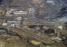
The Gorki Gorod resort is located in the village of Esto-Sadok in the Mzymta River valley, 40 kilometers from Sochi International Airport. You can get to the resort by bus, taxi or the Lastochka train. It is worth noting that car sharing is very popular in Sochi.
The main attraction of the resort during the summer season is undoubtedly the cable car. The cost of a walking ticket for the Gorki Gorod cable car in the summer of 2019:
- one ascent / descent from 540 meters to 960 meters ("Upper Town")
- adult - 300 rubles,
- children - 200 rubles;
- one ascent / descent from 540 meters to 2200 meters ("Panorama")
- adult - 1400 rubles,
- children - 850 rubles.
The excursion ascent on the Gorki Gorod cable car to the Black Pyramid peak takes place with transfers at the stations. To get to the goal, you need to make several transfers between the gondola and chair cable cars: K1 - K2 - K3 - K4 - K5. So, let's go! Into the mountains! 

Important! If you decide to visit the resorts of Krasnaya Polyana, be sure to take warm clothes with you, because the air temperature in the mountains is lower than on the Black Sea coast. The temperature in the alpine zone, at an altitude of 2000 meters above sea level, does not rise above 15 ° C in summer.


Observation deck at an altitude of 960 meters - "Upper Town"
The first lift K1 lifts from the "Lower City" from a height of 540 meters to 960 meters above sea level to the "Upper City". Gondola-type cable car cabins, some with special mounts for mountain bikes. This was done because the Gorki Bike Park is located at the Verkhniy Gorod station with trails of varying difficulty for downhill - downhill mountain biking. You can also take a cable car from the Verkhniy Gorod station to the Polikarya waterfall eco-route if you have purchased a walking ticket for all the lifts.
At the Verkhniy Gorod station there is a large observation deck, many restaurants and cafes. Here is a zone of the forest mountain belt, so it is worthwhile to linger and walk a little around the station to enjoy the views and clean air.
Important! If you are a guest of one of the hotels in the "Upper Town", then the ascent to K1 will be free for you.
Observation deck at an altitude of 1460 meters
The second lift K2 is part of the main excursion route on the way to the top of the Aibga ridge. Already from the cabins of this lift, a view of the Pseashkho mountain range, which is located opposite the Aibga ridge, opens, together they form the gorge of the Mzymta river. You can see the snow-covered peak in the center - Sakharny peak, 3189 meters high, the peak to the left of the peak is Pseashkho Yuzhny, 3251 meters high, and to the right of Sakharny peak, Kozhevnikov peak 3070 meters. And in front of these peaks there is the Bzerpinsky cornice, on which a popular tourist hiking route passes in the summer season. 


The station is located at an altitude of 1460 meters above sea level. In just a few minutes, from the zone of the forest mountain belt, you find yourself in the subalpine belt. The landscape and the ambient temperature change. It is cooler here than at the stations "Nizhniy Gorod" and "Verkhniy Gorod". In summer, the temperature in the subalpine belt does not rise above +24 ° C. Not far from the station there is a rope park and an ecological route called "Relic Forest". A visit to the rope park is paid, and the entrance to the "Relic Forest" eco-trail is free. If you have time, then you should definitely take a walk along the trail of the eco-route among the majestic fir trees. 

Observation deck at an altitude of 2200 meters - Black Pyramid peak
The third lift K3 raises to an altitude of 2200 meters above sea level into the zone of alpine meadows. Here, at the top of the Aibga ridge, the most colorful ecological route called "Alpine Meadows" is laid. The length of the route is 3 kilometers with a vertical drop of up to 150 meters, so it will take a lot of time to complete it. As a reward for decisiveness, the tourist will find stunning viewpoints on the eco-route along the mountain circus. 


But at the upper station, it is not only the Alpine Meadows eco-route that is interesting. On the K4 and K5 chairlifts, you can make a dizzying descent to the nearby mountain circus, and an equally exciting climb to the foot of the Black Pyramid. A real attraction with a height of 150 meters awaits tourists on the K4 cable car. After a short gentle ride, the seats of the K4 lift rush almost vertically downward, exciting emotions are provided for everyone, especially those who are sensitive to altitude. Before changing to the last cable car, you can walk to the "Bear Falls" or the "Valley of the Rhododendrons". 


The last ascent on the K5 cable car leads to the foot of the Black Pyramid - the highest peak of the Gorki Gorod resort. The height of the peak is 2375 meters above sea level. An excursion climbing route has been laid to the top of the Black Pyramid, which can be walked with insurance under the supervision of an instructor.
From the upper station of the K5 lift, amazing views of another mountain circus open. And also from here you can see the Mountain Olympic Village on the "Rosa Plateau", built at an altitude of 1170 meters above sea level in the resort "Rosa Khutor". 


An excursion ascent on the Gorki Gorod cable car and a walk along some of the resort's eco-routes can take a whole day. It will be quite difficult to manage to visit all the natural attractions of the resort in one visit. But this is a good reason to come back to the resort again.
It was the fastest and most fantastic trip to the mountains. On my way to work on Monday morning, I did not even suspect that in just seven days, on Sunday night I would be lying "without hind legs" thinking about what happened after all! This is how it was ...
This trip to the mountains came up unexpectedly. On Monday I go to my beloved risk.ru and see a fresh post with pictures of Krasnaya Polyana ... It's a damp autumn in Moscow, and there, in the sunny south, there is a warm sun and peaked mountain peaks. I wanted to visit these mountains so many times in the fall, and then again I was late ... Or not? We must hurry !!! On Gismeteo, starting from Thursday, all days are adorned with the sun and the nights with stars. Previously read reports emerge from my memory, in which it was told about the periods of good weather in the fall! If you take a day off on Thursday-Friday, then you have four whole days at your disposal! My heart beat a hundred per minute. Chugush, Achishkho, Mzymta ... Familiar names of mountains and rivers emerge from the memory.
On Tuesday morning I call Natasha in Sochi. “Hello, Natalka, hello! If I arrive the day after tomorrow, will you go with me to the mountains for four days? " Natasha is "our man", but I managed to surprise her too. The boss Katya (I grade in mountaineering, climbing the five-thousanders of the Pamirs) cannot help but let go, and the persuasions of my colleagues leave her no chance. At lunchtime I call Natasha in Sochi and just say that I bought tickets. She says she comes with me. Fine!!! In the second half, I create a post on the Kuban tourist forum. Topic: "where you can go for four days." At the same time I am sending Natasha a list of equipment.
Climbing Achishkho (2391 m)
I'm in the mountains again. Let's leave the bustle of the Moscow rhythm, empty chatter and unnecessary words. Exhale and relax. Now only photos ...

Beech forest at the beginning of the trail on the Khmelevskie lakes


After spending the night in a tent at an altitude of 1800, at dawn the next day we went to the ascent to Achishkho!


The first of the three peaks of Achishkho appeared
Quite unexpectedly, after another turn of the path, Chugush appeared. The same mountain before which we retreated two years ago, during our multi-hike across the Caucasus and Abkhazia!

Chugush (3238 m.)

Not a bad place for bouldering!
Less than an hour later, having crossed a small spur, we find ourselves in the Achishkho circus. Waterfalls are rustling, the summit is already close!


The weather whispers, time is running out. Why not have a full lunch break? =)

Famous Krasnaya Polyana tea! =)))

Fresh snow at 2100!

Fantastic sea view opens from the Achishkho ridge !!!


Along the wide ridge to the top!

Ruined rocks - the last meters of the ascent to Achishkho

At the top of Achishkho. Behind below - the village of Krasnaya Polyana.


From the last, third, summit we go down straight down the slope ...

North view. In the distance, on the far left, are the peaks of the Fisht-Oshtenovsky massif, in the center is Chugush.

East view. It's a pity, but Elbrus is not visible = (((

Small lake in the eastern circus of Achishkho
The day turned out to be beautiful and very eventful. Lakes, waterfalls, snow, a beautiful summit ridge, four-thousanders of the Greater Caucasus ... For the last hour we walked along the trail at dusk, and we approached the camp in complete darkness. In such cases, GPS helps a lot - a backpack with a tent hidden in a dense forest was found without any problems!
P.S. Exactly five years later, in November 2012, I went to Achishkho in one day!
Day 3
Today we have a difficult day. First you need to go down to the village of Krasnaya Polyana, and this is a little, a lot minus 1200 meters, which is already good for your beloved knees. But this is only half the trouble! Next, we need to get to the Alpiki Service cable car, jump on it to the top of the second stage (it does not work further, prevention is before the start of the winter season) and then, from a height of 1100 meters, climb as high as possible in order to climb the Black Pyramid the next day !


Morning exercises before the start of a difficult day


The descent went without problems, although it took a lot of strength. In the first part of it there is a very sharp drop in altitude. The trail is excellent, but our knees were cracking at the seams :) We go down to the village, have lunch in a cafe at a Lukoil gas station and start the second part of our program !!!
Climbing the Black Pyramid (2375 m)
ATTENTION! Unfortunately, a few years after this hike, a cable car was laid across the spur of the Black Pyramid and the route lost its former attractiveness. Now it remains to look at these photos and remember what Polyana was like before the Olympic construction .. (Note from 2012)

Famous Krasnaya Polyana peaks. The Black Pyramid is in the center!

Freeride and Salomon stores in Krasnaya Polyana (now closed. Approx. 2016). But we have everything and we pass by :)

Cable car Alpika Service
- Dashur -
The Black Pyramid of Amenemkhet III in Dashur is located 1.3 km east of the Broken Pyramid (as well as the White Pyramid of Amenemkhet II at a distance of 1.3 km from the Red Pyramid).
3D panorama of the Pyramids of Dashur.
Use your mouse to rotate the panorama. Ctrl - zoom out, Shift - zoom in + cursor keys:, ↓, ←, →
The Black Pyramid was first visited by John Perring and Karl Lepsius. This happened in the middle of the 19th century. A more thorough study of the Pyramid in 1894-1895. conducted by French archaeologists Jacques de Morgan and George Legrain.
The height of the Pyramid is 75 m;
The slope of the slope of the edges is 57 °;
The length of the side of the base is 105m.
The pyramid of Amenemhat III has a very complex internal architecture, unusual for the builders of the XII Dynasty. There are two entrances to the Pyramid. The first is located in the southeast corner of the eastern side of the Pyramid. It leads to the Descending Corridor, which is equipped with a staircase. The corridor leads into a labyrinth with many passages and chambers located at different levels on the eastern side of the Pyramid. The Burial Chamber with a gable vaulted ceiling is oriented from east to west and, like most of the underground chambers of the Pyramid, is made of blocks of white limestone.
The second entrance to the Pyramid is opposite the First, on the western side of the Pyramid, from the southwest corner and leads to the two Burial Chambers of the Queens. It is believed that the first Burial Chamber belongs to Queen Aat, the name of the owner of the second Burial Chamber is unknown.
A series of intricate passages connect the Western rooms of the Pyramid with the East rooms.
The pyramid is surrounded by double walls made of unbaked creep around its entire perimeter.
It is believed that Amenemhat III built and then abandoned the Pyramid at Dashur in 15 years of reign, starting the construction of a new Pyramid at Hawar. Perhaps the reason was the unstable geological zone chosen for the construction of a megalithic structure near the Nile Valley. The pyramid was built just 10 meters above sea level. The fragile material of the main walls allowed groundwater to seep into the main thickness of the Pyramid's masonry, thereby making it heavier. This resulted in a gradual subsidence of the main array of masonry, which provoked the formation of cracks in the load-bearing walls of the underground premises.


At present, both entrances to the Pyramid of Amenemhat III are completely filled up.


In 1900, during an inspection of the vicinity of the Pyramid of Amenemkhet III by the Egyptian Antiquities Organization, a perfectly preserved basalt Pyramidion was found on the eastern side of the structure, decorated with inscriptions and images. Whether it ever sparkled in the rays of the bright sun of Dashur at an altitude of 75 meters from the surface of the plateau is difficult to say ... Time took with it the original appearance of the Pyramid. Now this artifact is located in the central hall of the Cairo Museum, striking visitors with the high precision of its geometric parameters, along with the impeccable technique of applying inscriptions and drawings on the basalt surface mirror-polished by ancient masters.
It is located five kilometers from Krasnaya Polyana, in the Aibga mountain range, which includes three more peaks. The height of the Black Pyramid is about 2375 meters. The summit itself is so named due to the fact that it has the shape of a triangular pyramid.


Photo by Dmitry Kovinov http://www.kovinov.com/

Photo by Dmitry Kovinov http://www.kovinov.com/
The peaked mountain Black Pyramid is one of the favorite places for climbers, its slopes are very steep. The top offers a panoramic view of the Greater Caucasus Mountains and the Mzymta River valley. On the summit ridge of the mountain, you can see the so-called "kars" - cruciform depressions formed by ancient glaciers. On the northern slope of the Black Pyramid, there is the largest waterfall in Greater Sochi (it is also one of the highest in Europe) - the Polikarya waterfall. Its height is about 70 meters, the entrance to the waterfall is paid. On the other slope of the peak there are ski slopes that are part of the Gornaya Karusel complex.
The Black Pyramid summit on the map:
The map is loading. Please wait.
Unable to load map - please activate Javascript!
Summit Black Pyramid
It is located five kilometers from Krasnaya Polyana, in the Aibga mountain range, which includes three more peaks. The height of the Black Pyramid is about 2375 meters.
Summit Black Pyramid 43.641044 , 40.266438 It is located five kilometers from Krasnaya Polyana, in the Aibga mountain range, which includes three more peaks. The height of the Black Pyramid is about 2375 meters. Summit Black Pyramid
To get to the Black Pyramid, you must first get to Krasnaya Polyana. And already from it you can even walk (a taxi in Krasnaya Polyana is very, very expensive). Experienced climbers with special equipment will reach the top in less than a day, provided that they come out from the bottom at dawn. The route runs through beech and fir forests, then through subalpine meadows.
Coordinates:
Latitude: 43.641044
Longitude: 40.266438