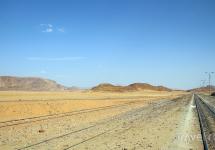
The kurumnik passed, but it did not become easier to walk, because the ascent to the Khudozhnikov Pass began. This pass has 2A-grade of difficulty, although from the side of Lake Nizhnee Buibinskoe it is not difficult, the path goes along a grassy slope. The height of the pass is 1880 m.
However, not difficult in any way means easy! It's getting harder and harder to climb, and the slope is steeper.

On the lake I see a group of swimmers, and the water is very cold there.

I slowly climb higher, I have to rest often, and at the same time I take pictures. There are more and more people going to meet and along the way. The feeling that you are walking in a city park.

And finally, I got to the saddle of the pass.

From here, a magnificent view opens up, both to the west and to the east! Fortunately, the weather is favorable for me!


Peak Molodezhny.


This is how Lake Lower Buibinskoye looks from the Khudozhnikov Pass.

And this is the Lake of Artists, the goal of my trip. Although it would be more accurate to say the end point. And the main goal is Parabola, which looks good from this lake.

Climbing the pass, I found a bunch of people, and mostly children. The group leader came up to me and said that he was asked to take me with them, and he respects this woman very much, so he could not refuse.
In the process of getting to know each other, it turned out that this is a group of "difficult" teenagers from Abakan at the age of 14-16. I don't know why they are so difficult there, I really liked the guys, they are polite, sympathetic, persistent, not lazy. There were 8 children, a leader and three teachers.

At the pass, we had to wait for the guys who had not yet arrived for 30-40 minutes. I spent this time with benefit, rested and took pictures. Before going downstairs, I put the camera in a backpack so that it would not interfere, so I did not take pictures during the descent.
Soon we went, at first we walked a little towards the peak of Cadets, and only then we sharply go down. When descending towards Lake Khudozhnikov, you need to find a path on the saddle that leads up, and after 50 meters leads to a stone manhole.
After descending the couloir, we go down the middle talus, although there seems to be another path, easier. The descent was so steep that if I were alone and did not see how people were going down it, I would never go.
For me all this was the first time and therefore difficult and scary. I saw how easily the boys overcome obstacles and therefore tried to keep up. By the way, I was not a burden for the group, I always walked with everyone together, not lagging behind. The group was closed by a teacher, apparently for insurance.
During the descent, we stopped several times to rest. All the time I was not letting go of one thought: "How can I climb back to the pass !?" The pass from this side was so steep, probably 75 degrees! An almost sheer rock.
Be that as it may, at last we all the same went down into the valley of huge stones! Someone is tired and resting, and the leader Rudi and Dima easily ran up a huge stone. The slope of the stone is large, you need speed and dexterity to run upward immediately.


And the boys are resting, some are very tired, although at this age the strength is restored quickly.

Having rested, we continue our journey further. You have to walk over huge stones or between them. The road is marked by pyramids made of stones, sometimes you don't know the road to the left or right of it. It is difficult and difficult to go again, but we go forward to the intended goal.
Finally, we passed the stone labyrinth and it becomes easier to walk. My backpack weighs only 8-10 kg, but what is it like to go with a weight of 20 or 30 kg? After all, if you go for a long time, you need to take many times more food. And now, after such a difficult path, “Parabola” finally appeared, though not in all its glory yet.

And soon I saw the long-awaited Lake of Artists. Although it is still up to him to go and go.


And yet, soon we reached the lake, the time is 16:30, i.e. it turned out that I walked from the base to the lake in 9 hours 30 m. We set up tents, collected dry firewood and lit a fire. By the way, by order of the head, only “difficult teenagers” were engaged in the fire and cooking. I also made a little of my help to the guys in collecting firewood.


While the guys were preparing dinner, the "elders" enjoyed the beauty of nature. And since the weather was warm, I started encouraging them to swim. And soon after me all climbed into the water. Having plunged once, remembering that I had not taken a camera with me, I ran after it. Running, of course, did not work, because boulders lay around, but as best he could.
He brought the device and captured all the swimmers. Although the water was not just cold, but VERY COLD, there were more than enough people who wanted to experience the effect of cold water on the human body.

The whole team is assembled: Nina, Andrey, Dima and Rudis.

To capture myself while swimming in the Lake of Artists, I asked our only girlfriend, Nina. She did it just fine, like swimming in cold water. The first sensation when you get into cold water is an immediate desire to get out of it as soon as possible.
And since I experienced it three times, I realized that every time my desires change and my body slowly begins to get used to cold water. Here we are so uncomfortable getting out of the water, because there are large boulders at the bottom and we have to look for a foothold to take the next step.
After swimming in icy water, we became completely different people. Fatigue disappeared, vigor and good mood appeared. While we were swimming, dinner was already prepared by our guys. After dinner, we sat and talked for a long time. From them I learned that there is one more park of topiary art in Abakan, which I took into account.

This is our main leader and guide, who knows all the paths of the reserve. Many thanks to him for the fact that I was able to see the most interesting places of the Ergaki reserve.
After dinner, I walked around a bit with a camera and took pictures of the beauty around us.

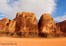
The unique and only rock Parabola on the planet. The height of the rocks is 500 meters. According to legend, this is an ancient Lemurian spaceport. Rock Parabola (Brothers) is one of the most striking symbols of the Ergaki Natural Park.
Her picks are called Big Brother (left) and Slim Brother (right). The saddle between the brothers has an almost perfect parabola shape, which is why some people do not believe that such a rock exists in reality.
This saddle is a pass and can be climbed without equipment in dry weather. The brothers themselves can also be climbed. The easiest way is for Big Brother. By the way, my companions were going to "run away" to Parabola in the morning.
When I saw the rock, I strongly doubted the ease of conquering the "Parabola", although now, being far from it, and sitting at the computer, I think that this was probably possible. How much the sensation of a person at a distance changes! I want to go back there and see, feel what I did not have time to do the first time.

To see the "Parabola" was the main goal of my trip.


 ,
the place is just for them, painting, beauty, in a word.
,
the place is just for them, painting, beauty, in a word. 
My tent

In the evening, a strong wind blew and caught up with dark rain clouds, we all, in anticipation of a downpour, rather hid in tents, but the rain turned out to be not heavy rain, but pretty wet the ground.


In the morning, when I got up and began to collect my things, everyone was still asleep. I had breakfast, put the remains of my things and the resulting garbage in my backpack and went to say goodbye to the lake and Parabola. Approaching the lake, I saw Nina, who had already woken up, said goodbye to her, once again thanked her for the company.
I cast a farewell glance at the surrounding beauty and went back. Time 7:30. I fulfilled my plan of the trip to Ergaki and with a sense of satisfaction I leave this beautiful place. And I go and think, in my head I have only one thought: "How will I climb the pass?"
I remember the path and landmarks, but the very steep climb scares me. After an hour of walking, I came to the foot of the pass. After a little rest, I began to climb, walked carefully, because I am alone and if something happens, no one will help me, and casual tourists do not go so early. While I was walking, I did not see a single person.
I go up slowly, carefully, with stops for rest, the weather is cloudy, which is not very good for the mood, but there are also pluses in this. Not hot, but it's very hot for me to climb the mountain. Be that as it may, but after an hour and a half from the beginning of the ascent, I nevertheless climbed to the top of the Khudozhnikov Pass. Here I rested, took the device out of my backpack and took off a little.


Then he put the device back into his backpack and went down from the pass. Going down is also not easy, you need to step carefully, otherwise you can slide head over heels down. But in any case, it is already much easier than the climb passed. And soon I'm in the valley. I decided to go a little differently, visually chose a target and walked towards it along the shortest straight line.
Here again I took out the apparatus and took a few pictures. On my way I came across the snowfields of the past winter and the ground overgrown with moss. He walked for a long time, of course, tired, soon the clouds swelled and the sun began to warm. The heat made it even more difficult to walk. I decided to return to the base in a different way, I really didn't want to go the extra five kilometers. And he took the direction to the Tarmazakovsky bridge.

However, only later I realized that this option was not the best. I didn’t know the exact road, when I came across someone, I asked. And sometimes you come up, and the path bifurcates or even goes in three directions, you have to choose a direction, only relying on intuition. And she can let you down and then you will wind extra kilometers.
In general, with all sorts of difficulties and wanderings, at 13:30 I was on the Tarmazakovsky bridge. From here I intended to hitchhike to my base. However, those who wanted to give me a lift had to wait some time, although not very long. A recent resident of the Caucasus gave me a lift. The drive was only about 10 km and at 14:50 I was already sitting in my house at the base.
In general, I got there in 7.20. After taking a shower, we went to the dining room for lunch. Food has already been delivered, and we were able to eat tasty and inexpensive food. The rest was spent relaxing and walking around the base.
The next day at 7 o'clock in the morning, we leave "Ergaki", leave with a feeling of regret that we managed to see so little. "Ergaki" amazed with their beauty!
You have to come here for a longer time, but with the weather, as luck would have it, in any summer month the weather is very changeable. We left with confidence, we will definitely return here! Ergaki will not let you forget about yourself!
The beginning of the journey to the Ergaki reserve read
On the territory from the Urals to Kamchatka there are many traces of ancient civilizations, artifacts, ruins of cities, huge incomprehensible structures. For example, on the territory of the unique natural park Ergaki in the south of the Krasnoyarsk Territory. The imagination is amazing what can be found here.
Siberia is the ancestral home of our civilization, which of course is completely denied by scientists. Local residents from the Urals to Kamchatka can tell about the ruins of ancient cities, megalithic structures. All attempts to draw the attention of the scientific community to the findings have been unsuccessful. And only independent researchers-enthusiasts show a genuine interest in this area. It is necessary to conduct a study of the Stone Town in the Ergaki National Park.


Ergaki is a very popular place among tourists. All tourist groups must register. Not far from the road there is a base of the Ministry of Emergency Situations and a ski resort, which was supposed to be opened by Alexander Lebed in 2002. Largely thanks to him, the Ergaki Natural Park appeared. But the plane crash ended the life of the Governor-General. Now travelers come to the scene of the tragedy and only then to the mountains. This is a tradition.
Ergaki is one of the ridges of the Western Sayan. On an area of \u200b\u200bonly 15 by 20 kilometers, there are beautiful waterfalls, dozens of lakes and rocks of amazing shape.

Lake Bolshoye is the first attraction of the park. Although tourists call it Light. It seems to glow against the background of the taiga, especially in sunny weather. Another version of the name is Holy. It resembles a dome from above. Its length is only a kilometer, but its depth is 60 meters. There are dozens of tents around the lake. They come both as savages and in organized groups to the health camp.

Not far from Svetly is Bear Lake. Previously, the owners of the taiga were seen there. They say that they even went to the camp and emptied their backpacks. Probably they were looking for condensed milk.
The weather in Ergaki is changeable. Quite humid, it can snow in the summer. Here, in addition to the bear, you can find the ermine, roe deer, lynx, wolverine, snow leopard and red wolf. The flora is also very diverse. Several dozen rare and endangered plants can be found in the park.

The famous peak named Dragon's Tooth. In 2010, Krasnoyarsk extreme people jumped from it. We were preparing for a whole year. We ordered a helicopter. It was impossible to carry the equipment on myself, only the ropes weighed half a ton. And all for the sake of five seconds of free flight. They are the only ones who have done it so far.
Ergaki is a specific system of peaks. There are even stones in a certain order. And in this system, on the Sleeping Sayan ridge, there is one Hanging Stone, which stands on the top of the mountain and it is not clear how it holds itself without a fulcrum. By all the laws of physics, it should have collapsed a long time ago.

How did this giant stand for many thousands of years? Unclear. Everyone comes up and tries to move him. According to legend, if the Hanging Stone falls, then the Sleeping Sayan will wake up and the world will be in some kind of danger.

Earlier Ergaki was considered a sacred territory. Here they were initiated into shamans. Each peak has its own legend. The very word "ergaki" in translation from the ancient Türkic means "fingers". According to one of the legends, these are the fossilized fingers of the hero Yenkul.

The gods put him together with his brother Sayan to guard the sacred lakes. But Enkul was angry and envious and dreamed of defeating his brother. Therefore, he drank the magic drink, but overdid it, became a giant and fell into the ground. Only fingers remained of it. According to another legend, these fingers belong to a batyr - a spoiled youth who wanted to live with the gods. For this he was exiled to Tartarari.

But scientists have their own version. Ergaki owes its unusual relief to the climate that existed many millions of years ago. The mountains were covered with glaciers, then they retreated and at the same time, like bulldozers, knocked down mountain peaks, giving them bizarre shapes. As if!


There is also a popular version that this is the work of some ancient civilization, which possessed energy unknown to us. It is not difficult to find huge rectangular blocks or completely flat edges, perhaps these are traces of a grandiose dam, built long before anyone in Egypt built the pyramids.

Some stones look as if they were melted after some kind of explosion. There is also polygonal masonry. There are rocks as if mirror-polished by someone. Some places are very similar to Gornaya Shoria at the junction of the Sayan and Altai.


Glaciers have created numerous mountain lakes. One of the highest peaks of Ergaki is Ptitsa Peak, 2221 meters high. This peak was chosen by climbers and rock climbers. Climbers of the regional federation hold camps here twice a year. Here you can protect the first and second sports categories.

The international mountaineering festival was also held in Ergaki. There are no easy routes. Mostly routes for strong climbers. There are fives, sixes. You must be good at working with ropes. The routes are rocky, but sometimes the weather "helps" so much that they become very dangerous and not passable.

Rock Oreshek
The weather is capricious, it often rains and snows in summer. Then everything will freeze up, try to get through. If you did, then you did it specifically. The climber here learns to concentrate, to control himself. This is not immediately possible, it can be very difficult. But it comes in very handy in life.

The topmost picture shows the Parabola rock. How is this possible? Mathematical precision of proportions. Or maybe it really is a man-made object? After rain, Parabola takes on a metallic sheen.

The Parabola and the Hanging Stone are probably the most famous sights, one might say the symbols of Ergaki.

Near the lake of the Mountain Spirits. If the spirits are out of sorts, and this happens often, then tourists find themselves in full "milk". Everything is hidden in a thick fog.

A cascading waterfall is very beautiful on the way to the lake.

Lake of Artists. The beauty is indescribable, it is not surprising that painters strive here. Indeed, depending on the lighting, the landscape is constantly changing.

Akaban - about. Karovoe — radial on Hanging Stone and the Oreshek rock - pass of Artists - about. Artists - radial on about. Malachite Bath - Colored lakes - g. Dragon Tooth (2176m)- about. Mountain Spirits -pass Bird (1A, 2097m)- about. Light - Rocks-Elephants- * Dinosaur Peak - p. Jerboa - Akaban
Day 1. Abakan
The meeting and gathering of the group takes place at the Abakan station. We distribute public cargo and food to all participants. Then we load our things into the transport and go to the beginning of the route - to the Tarmazakovsky bridge. We will walk 8 km from the bridge and camp for the night.


In the evening we go to the radial exit to the Hanging Stone and Oreshek Rock. Gigantic fragments of rocks carried by the glacier are visible on the tops and slopes. This is how the famous piece of rock weighing about 600 tons, hanging on the edge of the cliff, arose. The area of \u200b\u200bits contact with the plane is no more than a square meter. Strikingly, neither long-term weathering processes nor regular earthquakes can move the Hanging Stone. Many legends are associated with him.


Day 2. Lake of Artists
Today our goal is the Artists' Pass and Lake. Early in the morning we start the route. We go to the picturesque Lake of Artists, located right under the Parabola pass (Lower Parabola, 1750 m). Our path will go up to the Khudozhnikov Pass. Its height is 1926 meters. The lake fascinates with its mirror surface. And the reflections of stone ledges and trees growing on them give a special charm. You cannot leave here without taking beautiful photographs.


We set up tents in a camping by the lake and relax.
Kilometers: 7 km.
Day 3. Malachite bath
After long journeys, we rightfully deserve a rest. However, if you want, you can make an easy radial hike to the Artists' waterfall and to the Malachite Bath Lake.


The lake got its name due to the fact that it lies in a rocky depression of the Taigish River, surrounded by taiga on all sides. The lake is almost always in the shade of cedars, which gives its surface an unusual shade. Added to this is the optical effect that occurs when the depth changes. On the one hand, a waterfall from the Lake of Artists flows into the Malachite Bath in noisy jets.


Day 4. Dragon's Tooth
Today our goal is to conquer Dragon's Tooth peak. We get up early and early in the morning and make a radial hike to the majestic peak. Dragon's Tooth is the highest (2176 m) and at the same time the most accessible of the Ergak peaks. Both the most difficult routes and simple ones are laid to it. On the way, we will go to the very beautiful Colored Lakes. After the ascent, we return back to the camp. We will stay overnight.
Distance: 15 km.


Day 5. Pass Bird
Today we leave the Lake of Artists and go to Lake Svetloe. We will conquer the high, but not very difficult Ptitsa pass (2097 meters (1A)), we will go to one of the main attractions of Ergak - Lake Svetloe. It is as if surrounded by a dense cedar-spruce forest, climbing gentle mountains, above which two peaks rushed upwards - Bird and Star. Black-throated loons have chosen the waters of Svetly. If you have the strength and desire, you can climb the Ptitsa peak - 2221 m. We will spend the night on the picturesque coast. On the way, we will visit the Small Brother rock and climb to the Lake of Mountain Spirits - the highest and deepest lake of the Ergaki ridge. Such greatness and all-consuming beauty of mountains and water is difficult to find anywhere else. The parabola will especially amaze you.
Let's go: 7 km.


Day 6. Rocks of Elephants
We go radially to the Elephant Rocks, on the way we will climb to the top of Mount Vidovka, from where we will see Lake Zolotarnoe. There will be a magnificent panorama of the Zvezdny Peak (the highest point of Ergak) and the Dinosaur Peak. We spend the night on the familiar shore of the Light.
Distance: 8 km.


Day 7. Reserve (or Dinosaur Peak)
Considering the complexity of the Egrakov's relief, climbing the passes is possible only in good weather. Therefore, the instructor leaves this day in reserve. If the weather allows us to go through the entire route according to plan, today we will climb the Dinosaur peak. We will have to climb a steep slope, but the panoramas that we will see there are worth it. Then we will have a walk to the "Dinosaur's Head" and a descent to Zolotarny. We will return to the tents late in the evening and are quite tired - the passage is long, and the terrain is rather swampy.
Kilometers: 18 km.


Day 8. Return home
Packing up early and heading back.
Let's go to the road along the Tushkanchik river. Returning to civilization, we will load into the transport and leave for our homes. But the "lake" country and bizarre outlines of rocks in the Western Sayan Mountains will leave an indelible mark on your heart.
Distance: 8 km.
Route thread: Abakan - Usinsky tract - Tushkanchik river - Svetloe lake - Tushkanchik pass (n / c) - Nizhnee Buibinskoe lake - Khudozhnikov-2 pass (1A *) - Nizhnyaya Parabola pass (n / c) - Bird pass (1A) - Svetloe lake - Zvezdny pass (2A) - Pikantny pass (1B) - Vidovka pass (n / c) - Svetloe lake - Tushkanchik waterfall (radially) - Zolotarnoye lake - Zeleny pass (1A) - Bezrybnye lake (radially) - Zapadny Bliznetsy pass (1B) - Ascent to the Dragon's Tooth peak (2176 m) - Zharki pass - Vostochny pass (1A) - Bolshoye Buibinskoye lake - Upper Buiba river - Lugovoy stream - Svetloe lake - Tushkanchik river - Usinsky tract - Abakan.
Key points along the route (Google Earth): download
Preparing for the trip to Ergaki
Ergaki are famous for their beauty not only in Siberia, but throughout the country. Alpine relief, deep trough valleys, tarn lakes, numerous waterfalls ... All this makes the trip to Ergaki a wonderful place for connoisseurs of pristine nature. It is also important that you can get to Lake Svetloe or Lake Raduzhny (starting points of most routes in Ergaki) in just 3-4 hours of trekking from the Abakan-Kyzyl road. Most of the peaks of the main Ergakov ridge exceed 2000 meters, the highest point is Zvezdny Peak (2265 m). Most of the passes have elevations exceeding 1500 m and are located in the alpine belt. About 15 passes have been qualified, including 4 passes 2A, 6 passes 1B kt.
In the summer of 1996, German Nikolaevich Babushkin gathered a group on a hike across Lake Baikal. But due to a number of circumstances, the trip to Baikal had to be postponed to the next year, and I was transferred to the caring hands of Vladimir Georgievich Fiofilov, who was gathering a group to Borus. However, on one of the evenings of the Zelenogorsk tourist club "Firn" Rimma Ivanova appeared and offered us another option - a trip to Ergaki, where she herself was going with her children in mid-June. On that and decided. The training camp began.
The final composition of the group:
- Vladimir "Ded" Fiofilov - Mountain IV, 43 years old, head
- Nelly Simonova - III mountain, 48 years old, manager
- Natalia Ryabykh - III mountain, 30 years old, doctor
- Dmitry Kovinov (that is, me) - no experience, 15 years old, photographer
- Sergey Rubanenko - no experience, 14 years old, remaster
A food ration was prescribed. I was assigned to purchase, pack and carry during the entire trip
- three cans of stew
- kilo of dried potatoes
- 2 kg sugar
- 1.5 kg of dried smoked sausage
- three packs of jelly
- 1 kg of raisins
- 1.5 kg loin
- 1 kg of cookies
- crackers from 2 loaves of bread
- 5 cans of canned fish
- 1.5 kg semolina
The result is 12.5 kg. The rest had about the same, but of course other products. Thus, our layout for this trip to Ergaki pulled 850 grams per person per day.
From public equipment I carried: a two-handed saw, a coil of 11-mm rope, and from personal in addition to the usual: a chest harness, a carbine and tops. Plus, since my mom is a medic, I was tasked with assembling a first aid kit. The following medicines got into it: stomach pills, pain relievers, pills for infectious diseases, dressings, 200 g of medical alcohol, antiseptics and an elastic tourniquet.
It must be said that before the trip to Ergaki I was a real "teapot". I had no experience of large hikes, and most importantly at that time, practically no tourist equipment! I had to buy a backpack, a sleeping bag and an anti-encyphalitis suit, outlandish for me.
Road to Ergaki
So, the beginning of the trip (boarding the bus on the Zelenogorsk - Zaozernaya route) was scheduled for "five thirty on Monday." On Sunday, as a conscientious tourist, I packed my backpack (it turned out to be 37 kilograms !!!), tried to walk with it along the road near the house. Then it seemed to me not just heavy, but very heavy. Fortunately, before this campaign, I walked six times with a weight of 15-20 kilograms up the hill near the house (I put bricks in my backpack).
In general, on the appointed day, getting up at 4:20 in the morning, I conscientiously had breakfast and harnessed my dad to take me to the bus. Having approached the place, I found, or rather I did not find a soul from our group. In complete bewilderment, after waiting for the bus departure, I went to the "Grandfather". The doorbell was answered by a sleepy but already clean-shaven man with bewilderment on his face. In response to his bewilderment, I began to explain to him that our bus had already left, to which I received a quite clear answer: "Dima, the train from Zaozerka at seven in the EVENING !!!" Turning around, I went home and went to bed for another two hours. When my mother came home from work, she was very surprised why I was still at home. Then, without incident, we got to Zaozerka, and then to Uyar station.
In Uyar, new surprises began: it turned out that previously booked tickets for seats on the train were in different cars. After a short conversation between Natasha and the cashier, everything was settled.
The train went normally, and arrived in Abakan at 11 hours 15 minutes the next morning. We were lucky, and already at 12 o'clock we were sitting on the Abakan-Kyzyl bus. It should be noted that on the bus, most likely only we were Russian, the rest were Tuvans. The bus was good - Ikarus, and we hit the road. On the way, I slept a little, but after 3 hours MOUNTAINS began to appear. Here the whole dream vanished like a hand. Our bus, as it turned out, was good only in appearance.
In the village of Ermakovskoye, the bus made a big stop at a roadside cafe, where we, like almost all the passengers, had a hearty lunch. Almost immediately after Ermakovsky the road went uphill. Our Ikarus, like a "donkey", had to stop every hour so as not to overheat. Having climbed probably the highest point of the road, the belts on the engine broke and another hour stop followed. But despite these troubles, the impression of the mountains, seen mainly to the left of the direction of travel, was enormous. I looked at some "Sayan's head", at a "bird", "star" and could not even imagine that in three or four days I myself would be making my way among these peaks ...
Up the river Jerboa
Well, at five o'clock in the evening, the Tushkanchik river finally appeared, which we had been waiting for so long. Not having time to get off the bus, we saw our friend, Rimma Ivanovna, who was already waiting for us. We greeted and set off. But we didn’t go a hundred meters when we came to the camp. There were a lot of people, young and old: both children and adults. Some sat and talked, others joked, and still others fussed about the camp. After sitting in their camp, we moved up the Jerboa. I must say that at first the mood was not very good because of what we were told. Namely: "Two weeks before our arrival, just during the beginning of the campaign of Rimma Ivanovna's group, it began to rain and it rained from the 15 days they spent in Ergaki 12 days." The path along which we walked was dirty and wet. The backpack seemed terribly heavy to me. We walked with stops in 15-20 minutes. And after passing some kind of "ant hill" we met three guys. They turned out to be members of Rimma Ivanovna's group.
We decided to spend the night at a place with a funny name "ant hill". This was my first night in a tent and even more so in the mountains. The boys told us about the difficulties of the campaign, and looked very serious and important, apparently mistaking us for "dummies" who do not understand anything about real campaigns. In the evening, they cooked dinner and sawed wood. It was very interesting to look at the rather well-coordinated work of everyone in the camp, and I thought that I would soon know exactly what to do without any prompting. On this day we covered only 4 km, but it seemed to me enough. Clean run for about 1.5 hours.
Nice sunny morning. We go all the same up along the left bank of the river. About an hour later, we are blocked by a stream flowing into the Jerboa. It turns out that this stream flows from Lake Svetloye. Without crossing it, we go further along the coast, gaining altitude rather quickly. The mountains are shown on the left. You can clearly see the "Bird" and "Star" - the most famous peaks of the Ergaki ridge. We go out onto a huge field, completely covered with roasts and wild garlic. We collect a little for lunch. We turn left, and after 10 minutes we find ourselves on lake Svetloye.


Meadows with wild garlic and roast near Lake Svetloye
Baselag on Lake Svetly
Lake Svetloye is one of the most convenient places for a base camp with a circular route. From here it is easy to get to Lake Maloe Buibinskoe, to get into the valley of the Taigish River through the Lake of Mountain Spirits, or to be on Lake Zolotarnoe along a good path in just a couple of hours. It is here that we decide to set up our base camp, which will become the starting point of our three rings and one radial exit. There is warm water, a lot of places for tents, there is a lot of forest around and there are not many problems with firewood. In addition, it is very close to the road, and in which case, with light, you can reach the road in 2 hours.

We leave immediately after lunch. We take food with us for 3 days, and the rest will be taken away. Now there are 10 of us: there are five of us and Rima with four boys. We go around Lake Svetloye on the left, not far from the shore, we cross the stream along the logs, which originates here. Then we move along a good path. We pass several small "rotten" lakes, and go to the Bear key. We cross it on a thrown log, you can't go ford without insurance. Alpizba stands on the right bank. We go inside - no one. Then again along the path to the Tushkanchik river. We pass to the ford, and we take the path directly to the Tushkanchik pass (n / k), located to the right of the top of the Tushkanchik mountain itself, an ancient volcano with a destroyed crater.

Near the hut of Minusin people (they say it burned down after a couple of years)


Tushkanchik pass (n / a, 1700 m) - really n / a (none!) - forest, grass, sometimes even a horse trail. In a word - tyagun. The saddle is very wide. During a smoke break, we ran closer to the top. There, from the bottom of the crater, on the inner slopes, you can make technically difficult ascents using rock climbing techniques. Then we go down to the Maloe Buibinskoe lake. We approach the place of overnight stay only at 21:30. We set up our tents right on huge boulders, as this is the only dry and almost level place in the area. In addition, in the event of a downpour, there is nothing to fear that the water will go under the tent.
"Hanging Stone" and the Pass of Artists
In the morning we went to the "Hanging Stone" - a huge boulder on the top of the mountain, lying on the ground only in a small part, and forming a huge canopy. The name is due to the fact that this stone lies on the edge of a large cliff, so that it seems to be hanging. Many tried to push him, but no one succeeded, this stone is too heavy.

On the ridge near the "Hanging Stone"
Below - Lake Lower Buibinskoe

"Hanging Stone" - Ergakov's calling card!
Below - Lake Maloe Buibinskoe (Raduzhnoe)


At 16 o'clock we go to the Khudozhnikov pass (1B). The ascent from the camp on Lake Maloe Buibinskoe to the pass entry took only 1.5 hours. The ascent to the pass from the valley of the Lower Buiba river is very simple and takes no more than 30 minutes. We rest on the pass and admire the mountains. The pass is so named for a reason. Below is the most beautiful trough valley of the Left Taigish River. On the right you can see, resembling the blade of a bayonet shovel, the Zvezdny peak (2265 m), and a little to the left and in the distance - the Dragon's Tooth peak (2176 m).


Behind the highest peaks of the Ergaki ridge: Dragon's Tooth, Zvezdny, Bird.
The descent is rather difficult, as it passes through a loose of "live" stones, we descend immediately from the saddle - quite difficult. Some people recommend the following option for descent into the Taigish River valley: not descend directly from the saddle, but climb slightly towards Molodezhny Peak (on the left - looking into the Taigish River valley) to huge vertical boulders called “fingers”. There are three of them, you can go down between the first and second fingers, counting from the saddle. Even from the pass, I noticed that the foot of the pass was strewn with stones. Then I thought that it’s good that we don’t have to drag through the mud, we’ll jump from stone to stone. But what was my amazement when, as I approached the stones, I began to understand more and more clearly their real dimensions. The passage of the stone platform, which, as I thought while standing on the pass, would take about five minutes, actually took half an hour.
Having overcome the stones, some of which were the size of 3 or even a five-story building, two hours after the start of the descent, we found ourselves on a small, dry, elevated place, not reaching 500 meters to Lake Khudozhnikov. We set up camp.

Pass of Artists from the parking lot "Dream"

The evening was lovely. Looking back, I realized how large the scale of things created by nature is. Huge boulders in front, gigantic mountain ranges to the left and right, lake and brook behind. All this creates a feeling of something unearthly, not something that a person who has lived his whole life in tight city back streets gets used to.
The sun began its journey to the horizon and the camp became very quiet. And in such a huge place, constrained from all sides, there was such a silent, extraordinary silence for a person, which was interrupted only by one very melodic ringing of a stream running nearby, which began here its long journey to the Yenisei. One involuntarily thinks: “Isn't this an ideal place for human life? A place where there is no fuss, no quarrels, no fleeting desires. A place where I would like to really relax, a place where I would like to be in the moment of the highest happiness!
But back to mundane matters ... While the porridge was cooking, we made a sortie into the hut, with a strange name for a person who found himself here immediately after visiting a restaurant or supermarket called Dream. The dream turned out to be nothing more than a small depression in a huge boulder and boarded up by boards on one side. It was rather dark inside, but we could still see a large notebook lying on a wooden table. They brought it to the camp and only there they saw that it was nothing more than a “visitors' book”. It was filled with many different wishes that different travelers left in it. We also left our record.
After dinner, we sat around the fire for a long time, "weeding" anecdotes on a variety of topics.

In the parking lot "Dream"

16:15 - leaving the camp
17:45 - the beginning of the ascent to the pass
18:00 - 20:15 - descent from the pass
20:45 - camp at the Lake of Artists.
Valley of Mountain Spirits - Bird Pass - Lake Svetloe
After breakfast, the usual gatherings began, which consist in the fact that everyone runs around the camp and looks for their things, scattered before. Since there were still a lot of us (10 people!), The training camp dragged on. But at 11 o'clock we rushed to the assault on Parabola. The Parabola Pass is a drop between two peaks created by nature according to the canons of geometry.
Having passed through the kurumnik, we pressed ourselves to the Eastern Brother and then, along a small ledge located on its western side, climbed to Parabola. The path was not dangerous, but in some places the ledge was rather narrow and steep, so that in order not to fall, I sometimes had to grab the roots and branches of trees growing on the ledge. Having climbed the Parabola pass, I was literally stunned!
Everything told about some Valley of the Mountain Spirits and the lake of the same name turned out to be just a description of paradise from a man, in whose lexicon there are only two words ... The Valley of Mountain Spirits is perhaps the most beautiful place on earth from all that I have seen before. It is a valley surrounded on three sides by majestic steep rocks and a lake between them. The very shape of the lake resembles the footprint of the barefoot giant who created these unique mountains. The most interesting thing is that from the height of the Parabola pass, the dimensions of this lake really seem to be equal to the size of a human foot.
Upon returning from the top, right at the pass, we had a light picnic. The menu consisted of water, which we dragged with us, diluted this water with Invite (which “just add water”), bread (then we still had more or less stale bread), bacon, boiled pork and canned fish. Having had a snack, we set off.

After passing quite a bit we were caught by the rain. The first rain since our stay in Ergaki. Pulling on our capes, we huddled in one heap near a steep cliff. After sitting for about 20 minutes, we felt that the rain was over and moved on. After walking quite a bit, we came to the snowfield. Throwing our backpacks at lightning speed, we gave ourselves up to carefree fun: we began to ride on this snowfield on seats, and some just on the pope. Then it seemed that this is the best attraction in the world! Snow in the middle of summer. Wow!!!

After a little rest after running on the snowfield, we moved up, to bird pass (1A, 2097 m). The ascent was not at all difficult, apart from the danger of falling off in two or three places and getting hit on the head with a stone, which your friend inadvertently moved, who happened to be over you by luck. After climbing the pass and having a little rest, we decide to climb the "Shoulder of the Bird". The ascent was very easy, and at five o'clock in the evening we were at an altitude of about 2150 meters !!!


On the "shoulder" of the Peak Bird. Behind - Zerkalny Peak, Molodezhny Peak and Sleeping Sayan
Having enjoyed the height and the views of the Sayan Mountains opening in all directions, we moved down to the camp on Lake Svetloye, from which we left the day before yesterday. From the top it seemed that it was very close to him. Less than an hour later, a severe downpour hit us. Taking out our capes, we hid under them like turtles in shells and sat quietly and waited for the end of the downpour. We sat there for half an hour ...

Although there was very little left to our base camp, the most difficult, as it turned out, was still ahead. Moving almost constantly only downwards, we risked finding ourselves on wet ground. From fatigue, the legs were buzzing, attention was weakened and the members of the group now and then landed on the "fifth point". Dirty, wet, slippery ...
But slowly and surely we approached the lake, which I renamed the Lake of Hope. So I wanted to dry out and rest as soon as possible. Having passed a small swamp in the eastern part of the lake, at eight o'clock in the evening we went to our base camp on Lake Svetloye.
Without even changing into dry clothes, everyone fussed. “Grandfather” and I went to get the transfer. Serega and Natalya began to make a fire out of soaked branches. It was hard, but I had to work. Quite quickly and smoothly, we achieved that in an hour and a half the fire was burning, the tents were standing, the food was cooking ...

This was our farewell evening. Rimma Ivanovna with the guys was going home the next day. The adults drank a little goodbye. This day was perhaps one of the three most difficult days of this trip.
11:10 - exit from the camp
11:50 - Parabola. Climbing Peak Eastern Brother ()
13:55 - start of descent to the Valley of Mountain Spirits
14:40 - 14:50 - fun at the snowfield
16:20 - pass, climbing the "shoulder" of Ptitsa peak
17:50 - start of descent
20:05 - camp on the Svetloye lake.
Day on Svetly
Most boring day. It rained all day almost without stopping. We lay in a tent. They played cards, wrote diaries, studied maps of the area. Seryozha accompanied Rimma Ivanovna and the guys down to the road.
Super day: per. Star - lane. Spicy - lane. Vidovka
Day of Ivan Kupala. In the morning I carefully get out of the tent - if only no one doused it! But everything was dry! After breakfast, we set off. The day was planned to be the most difficult (it was like that!). Looked like our planned route for today is not sickly - three passes per day, and one of them is a specific "two a". So, with great zeal after yesterday's laying in tents, we moved up. After 40 minutes, we decided to rest and drink. This is where it all started! I don't remember who started first, but a minute later we were all equally wet from head to toe!
Having dried up, we start from the foot of the pass straight ahead. From the side of the ascent, the slope is very simple and we climbed the pass without incident. From it, an amazing panorama of the Brothers, the Spirit Lake and the Taigish River valley opened up. Everything was nice until I looked straight down, directly to where we were to descend.
Then, unexpectedly for myself, I felt a very strong desire to eat. Imperceptibly, in a couple of minutes, I consumed all my daily ration, which, according to the plan, was supposed to be enough for three or four hours. Descent from the pass, in principle, was not so difficult. And it was possible to do without even ropes, but we were reinsured. The descent in the most difficult part of the pass took us 2.5 hours and three pitches.

Zvezdny Peak (left), Zvezdny Pass (the closest couloir to Zvezdny Peak) and Bird Peak. View from the Mountain Spirits Lake
Having rested and calmed down (this is me about myself), we continued our descent. We went down to the Lake of Spirits, walked along its coast and made a break for lunch at the northeastern end. Noodles, sausages, crackers and ice cream for dessert. Personally, I didn't really like it, but just in case, the recipe: "A can of condensed milk is taken and mixed with fresh (if there is no fresh, then the old will go) snow."
While some comrades, for a sweet soul, devoured this mountain dessert, I preferred to wait until the snow melted and, mixed with condensed milk, would become just cold milk. It took about an hour for lunch. We walked around the side spur by traverse and went to the platform from which a very picturesque view opened up. Not wanting to lose altitude, we began to traverse towards the Pikantny pass.

So, without going down to the valley, we continued on our way. But it turned out that we could not avoid the descent as we came out onto the sheer cliffs. Having descended to the bottom of the valley, completely covered with huge boulders, we moved up. The path was quite exhausting, as I had to constantly jump from one boulder to another. It's good that we only have two backpacks for five, and we carry them in turn.
The path was rather exhausting, but then a pass appeared in the distance, and having gathered all our strength, we made a forward march. And what was our surprise when, instead of the desired pass, we ended up just at the terminal moraine of the already disappeared glacier. Morena created a dam and several small lakes appeared in the formed basin at once.
Now we clearly saw our target, it was 200 meters higher! Seryoga, having broken during a smoke break, rushed to the assault. We went slowly. I will say right away that it took us another 1.5 hours to climb, to the pass from the moraine.
After going around the lake on the left, we went straight to the pass, which looked quite menacing. But, coming up to the foot, we saw snow (after all, it was the northern slope). I began to climb directly in the footsteps of Seryoga. Seryoga, not thinking about the group, just ran to the pass. Therefore, I had to literally knock out the steps with the toe of my boot. Getting up quite easily, we saw Seryoga there, who immediately received a decent thrashing from Uncle Vova for separating from the group.
As time was running out, we rested for only five minutes and began our descent towards the third pass for today - Vidovka pass. Here, either from fatigue or, on the contrary, from joy that the most difficult part of the route was successful for us, everyone was amused: for about 20 minutes we walked and did not stop laughing, singing and telling all sorts of funny tales right on the go ... However, as soon as the descent ended and the ascent began, the good mood was gone. The ascent did not seem so easy. We are already pretty tired today!
Slowly but surely we crawled upward. The beautiful lake Zolotarnoye was right behind us. At 20:15 we went to the pass. Although it was still a long way to nightfall, even further away was the camp on Svetly, which became our real home.
After resting at the Elephant Rock - an outlier on the Vidovka Pass - we began our descent, as usual Comrade Natasha cheered up again. The descent was quite difficult and consisted of dense bushes. Walking speed dropped very much, and only by 11 o'clock we got to the camp and quickly, until it got dark, began to make a fire and put up tents. On this day we sat by the fire for a very long time, until two in the morning. True, around midnight Seryoga went to bed, while Comrade Natasha and I stayed by the fire. She told me a couple of legends about the Sayan Mountains.
It was one of the three most difficult days. Although we walked only 13 kilometers on the map, the feeling was all fifty!
9:30 - leaving the camp
11:45 - Zvezdny pass (2A, 1950 m.)
12:15 - 14:35 - descent from the pass
15:30 - 16:40 - lunch at the Lake of Mountain Spirits
18:20 - moraine under the Pikantny pass
19:50 - 20:15 Pikantny pass (1B, 1850 m.)
21:45 - Vidovka pass (1A, 1700 m.)
23:00 - camp near the lake Svetloye
Radial to the waterfall Jerboa
Of course, after such a load as on the previous day, the human body requires rest, and we (or rather our commander) decided to arrange a day. The sun was shining all day and the weather was wonderful, but it was the only day I regretted going on a 16-day hike. A week would be enough ...
But after lunch, I suddenly got a very bad stomach (the only ailment for the entire trip). On this day, we cooked jelly from any "pasture" (rhubarb, etc.). perhaps because of this rather tasty jelly, my stomach ached ... I did not take any pills, although they were, I just lay on the rug in the shade, curled up into a ball.
On this day, guests came to our camp: a woman and a guy of eighteen years old. I was immediately struck by their manner of communication with each other. They talked almost like courtyard boys. But Comrade Nelya knew this woman. At first we talked a little about everything, but then, upon learning that we were going to the waterfall, the woman calmed down a little. Then she began her long, and in some places even terrible story. She spoke for a long time, but the meaning of what was said was this:
All climbers know the legend about the black climber. A black climber is some kind of person who seems to have died, as I understood something like a zombie who walks in the mountains at night and can easily pass even the most difficult sections.
So, this very black climber walks in the mountains and sometimes looks into the tents of tourists. There is a legend that says that if a climber or any tourist in the mountains saw a black climber, it means his quick death.
She talked for a long time, and even my hair stood on end, although I tried not to believe in her stories ... Now, as I write this diary, I no longer remember how this woman moved on to another, even more terrible topic. Undoubtedly, possessing the talent of a skilled storyteller, she began her story with the fact that a boy in their group fell ill. According to her, the boy is an experienced hiker, and that nothing like this has ever happened to him. She told us that just not far from the Tushkanchik waterfall, which we were going to, or rather right by the lake from which the waterfall originates, there is some kind of hut - some kind of cave, in which some then a sorcerer (in her words - a hermit). It turned out that shortly before the illness of this boy (who had terrible headaches), he was at this lake. No one dared even come close to the hermit's dwelling, and this guy allegedly even went there. And according to her story, when he returned to the camp, he became very sick.
Punishing us firmly and firmly not to even come close to the hermit's dwelling, he, saying goodbye to us, went with her companion to her camp, which was, like ours, on the shore of the Svetly, but a hundred meters to the west. In parting, she said that tomorrow she and two guys would take the sick guy to the Minusinsk hospital. After she left, my soul somehow felt better. Painfully I didn't like her ...
But my stomach was still aching, and our group was still going to the waterfall, which was only 4-5 kilometers away. But the desire to miss a valuable shot overpowered the pain in my stomach, and barely getting up, I went light with everyone to the waterfall.
Having reached the waterfall without much adventure, I was still in pain. The waterfall was really beautiful. The height reached 12 meters. The weather was sunny, and we decided to swim in the icy stream of the waterfall. Having undressed to swimming trunks, Serega and I climbed up, to where the water was falling. But in the middle of the height, in one of the steps of the waterfall, we saw a rather deep pocket formed from the fall of water. After a little reflection, I still plucked up the courage and plunged about neck-deep into the icy water ...
In the first second, my heart almost stopped. But after a while my breathing began to quicken. Without sitting in the water and 3-5 seconds, I jumped out onto dry stones. The effect was amazing! All the pain in my stomach went away instantly !!! Having warmed up a little, and already with greater courage, I again plunged into the ice bath. The breathing increased again to 2-3 breaths per second, but it was great. A few minutes later, all of us, with the exception of Serega, were taking contrast baths. After waiting a little, Seryoga also decided. After five minutes of procedures, we settled down on a curtain to dry.

Having completely dried out, we went to the camp. On the way back, we stopped for an hour in an alp hut, where Ded's acquaintances from the Minusinsk Alp Club were. As I understand it, this time there were good guys in their camp. Their leader told us that they are going to the Bird and Zvezdny one of these days!
Having treated ourselves to free sweets and tea, we continued our journey. Half an hour later we were in the camp on Svetly, which had already become our home.
16:00 - exit to the waterfall
17:45 - 18:15 - waterfall
20:00 - camp (with a 40-minute stop at the hut)
Lake Zolotarnoe - Zeleny pass
After having lunch in the morning (that is, having breakfast), we were preparing for the third, final and largest ring with the planned five nights (later it turned out that six would be needed). As soon as we began to collect things, the guys from the neighboring camp walked past our camp in the east direction. They, like us, went to Lake Zolotarnoe. But since we were not ready yet, they moved on without us.
At 11 o'clock we were finally ready and went after them. Having rounded the ridge and Mount Vidovka, we went to the lake. After 1.5 hours we came to the lake where the guys were already standing. Some of them drank condensed milk from cans - a sight that was unbearable for me then, because we did not have so much tasty food. I went to the lake. There, our trousers rolled up, we sat with Seryoga on the stones.
After resting, at 13:30 we left the lake in the direction of the Vostochny pass, and our "competitors" were going to conquer the Pikantny pass, which we had passed two days earlier, but from the opposite, more difficult side.
As soon as we approached the foot of the pass, I suddenly (for the second time) had a stomach ache. I quickly "walked on a seal", but the pain did not go away. I said nothing and silently climbed the pass. It was pretty hard. And so the pass is stringy, arable, and even the stomach hurts! But somehow I nevertheless climbed the pass, on which there was a huge outlier boulder, in the shade of which we settled down for a halt.
After finishing off for five a bottle of water with a volume of 1.5 liters, eating a piece of cheese and sausage and eating it with five (one for each) sweets, I suddenly noticed that my stomach did not hurt, and finally I could carefully study the surroundings. And they were really beautiful: far ahead there was a lake that looked like two man-made pools. One of which was twice the size of the other. All this lake was called Bezrybnoe, on which, they say, good fish is found!

At half past five we began to descend. This pass (Green) was one of the easiest of those that we climbed during this trip, only 1A. Going down to the very foot, we saw on the left an amazing picture: as if giant towers were three majestic peaks. Between which narrow crevices could hardly be seen - passes. A little lower and to the left was a very beautiful waterfall, to which, unfortunately, we never went.
At first we wanted to set up camp right by the stream, which, like an unbroken horse, was jumping over the stones. But noticing a small dry hillock with a forest a hundred meters below, we moved there.
While the dinner was being cooked, I decided to heat a little, as the day turned out to be very hot. I went down the hillock on which we set up camp by the stream at its foot, no more than a meter wide and knee deep. Having undressed to my swimming trunks, I completely plunged into this icy stream. At first I was almost struck by a blow of cold, but after suffering a little, I got out of the water and settled on a stone under the evening, but still scorching sun. I repeated this operation three times, after which I returned to the camp.
After supper everyone went about their business. "Grandfather" and Comrade Natasha, as usual, were cut into "bulldozer". Its meaning is that the players have in front of them a square of 8x8 cells with one word inscribed horizontally there. Then, in turn, each player writes a letter there so that a new, as long as possible word is obtained. For each word, points are given on the basis of one letter of the word - one point. Having tried to play "balda" with ases, I soon realized that there was no chance for me. That evening, Aunt Nelya and I sat around the fire for various hiking bikes and legends.
11:10 - left the camp
13:50 - started climbing the pass
15:00 - 16:20 - lane Green (1A)
17:00 - camp
Radialka to Bezrybnye lakes
On this day, "because of the beauty of these places." But after spending more than a week in the mountains, it was unusual for us to sit all day in tents, especially in such good weather. After breakfast, at 12 o'clock, we went to Lake Bezrybnoe. The path was quite easy and in a little less than an hour we were on the stone shore of the lake. I, as usual, quickly took off my socks, rolled up my trousers and lowered my feet into the water. This simple procedure relaxes tired leg muscles surprisingly well.
After a little sitting on the stones (and "grandfather" and comrade Natasha even after swimming), we began to cook a small lunch. It was quiet and we noticed that two ducks were swimming on the calm surface of the lake. Taking out binoculars, we watched these wild and unafraid animals for half an hour. They swam so close that we could see them even with the naked eye. It was immediately evident that these birds had not yet heard the shots of guns and human voices.
After resting, we decided to walk to the isthmus between the two halves of the lake. Larch trees grew on the isthmus, and I broke off a piece of resin from the tree. At first it was rather bitter, but then it became nothing. The only thing is that the jaws are very tired from sulfur.
We returned to camp and fell asleep as usual.
12:00 - exit from the camp
12:50 - 17:00 - rest on Lake Bezrybny
17:45 - camp
Western Gemini Pass
After breakfast, at 9:50 am we leave the camp in the north direction. Before us is an unusual wall of three huge peaks, reminiscent of the towers of a medieval castle. We go to the middle pass - Western Gemini (1B). The ascent is simple, and after an hour of walking, at 10:50 we are near the pass tour. We take off another note, leave ours.

At 11:05 am we start descending a narrow, rather steep couloir. Here, perhaps, you will not manage without a rope, although you can go through it. The rope can only be useful on two sections, 8 and 5 meters. We passed them with a rappelling with top belay, the belayer passed these sections free climbing. In just 45 minutes we were having lunch under the pass. After a 2-hour lunch we decide to go further, but after five minutes we come across a place suitable for spending the night, and we decide not to go anywhere else, and at 14:00 we put up a tent on the left bank of the Ledyanoy stream near a small lake.


On the left is the Eastern Gemini Pass (2A), in the center - the Western Gemini (1B), on the right - the Vysotsky Pass (2A).
9:50 am - exit from the camp
10:50 - 11:05 - pass
14:00 - camp
Jail on Lake Ledyan
For 40 minutes walk without backpacks went to the Ice Lake. It's a pity that the visibility was poor, and in the afternoon a tedious drizzle started to pour in, and we spent the rest of the day in tents. Fifteen years later, Mikhail Popov perfectly captured the fantastic beauty of this lake in his photographs!

Climbing Peak Dragon's Tooth
We decide to climb the Dragon's Tooth (2176 m, 1A). We leave the camp at 10:35 and go down the Ledyaniy stream. At 11:20 we get up in front of the "second glass", leave our backpacks under the stones, and at 11:45, taking a snack and water with us, we start climbing.
The ascent to the top consisted of three sections of different nature. The first is with large boulders mixed with trees, and is quite steep. The second is more gentle, overgrown only with moss and wild rosemary. And the third - almost without vegetation, rather steep and stony. A wonderful summit in order to see the entire Ergaki ridge, and to ascend it does not require anything but legs and head. The ascent took less than 2 hours in total, and already at 13:30 the group was at the summit. The peak, with its southeastern slope, drops abruptly into the lake, forming just a huge 400-meter cliff, which even has a negative slope in its upper part!

From left to right: Natasha, Sergei, Neli Vyacheslavovna and me.
Behind - Zvezdny Peak and Bird Peak!
10:35 am - leaving the camp
13:30 - 15:05 - pass
18:00 - camp
Link Zharki pass - Vostochny pass
We got up early, as the pass we saw yesterday in all its "glory" was to be terribly long. And so it turned out. Leaving the camp at 9:50 am, we went straight ahead. The walk is rather difficult, as there are many trees, the slope is quite steep in places. We walked at this pace: 30 minutes of ascent - 10 minutes of rest. Little by little, at 11:50 we approached the pass tour. In the removed note we read: “A group of tourists from…. … Climbed the Zharki pass…. ”.
Indeed, during the ascent, we were somewhat carried away by traversing, and left a little more to the right than necessary. This was confirmed by the fact that Bezrybnye lakes were visible from the pass. Traverse the ridge to the saddle pass Vostochny (1A), thus completing the saddle ligament. At 13:15 we started the descent, which turned out to be somewhat heavier than the ascent, mainly due to the unusually hot weather, in the shade it was at least 30 degrees.
At the border of the forest, we went out to a very beautiful lake and decided to make a big lunch. The time was 14:35. The water in the lake turned out to be unusually warm, which is why the rest lasted until 17:00. Further - a rather difficult section. A lot of tall grass, stones are not visible at all, and spruce trees are not very conducive to fast movement. But we must pay tribute to the leader who led us exactly to the lake. The time was 18:25. We walked a little along the lake, and spent the night on a rather long, wooded cape, which we often visit, as there are a lot of bonfires and, sorry for such a word, garbage.
9:50 am - exit from the camp
11:50 - 13:15 - pass
18:25 - camp
Lake Buibinskoe - Lake Svetloye
One of the most difficult days of the hike. We had a little swim in the morning, the water is quite warm, and we left only at 12:40. We immediately followed a good path right along the lake. We quickly reached the southern end of the lake. We went into a fishing hut, which stood right next to the water. There was no one there, but there were crackers, salt and bread. It is immediately evident that this place is quite often visited.
Then we just walked along a very cool horse trail along the Verkhnyaya Buiba River, since there was not a cloud in the sky for the last 3 days, the trail was more like an asphalt path. But after walking along such a path for two hours, they began to notice that the paths began to diverge, and therefore worsen. Passed another half an hour, and turned sharply to the right, straight into the forest. It turned out that we had turned off successfully, and after 30 minutes we reached the Lugovoy stream. At 15:50 we got up for lunch. They ate saury, bread, sweets, halva, apricots, and prunes. So much because of the last day of the hike, do not bring the same food back. At 4:45 p.m. we went further, immediately crossed over to a ford, and further along the same horse trail up along the right bank of the Lugovoi stream.
Approximately two hours later, they came to a hut, quite large and strong. There was no one inside, but it is clear that shepherds live here. Move on. At about 20:15 we came to the confluence of two streams. They did not cross at once, but went along the same right bank. After 100 meters, we still cross this stream, since it is simply not possible to walk. Mosquitoes appeared from somewhere, and so many that we had to get out a repellent, lying around as unnecessary at the bottom of the backpack. After another 30 minutes, we realized that we left more to the left than necessary. With the penultimate strength, we sharply rise to the hill, which is very close, and we understand that we did not go along the right stream in vain. We descend directly into the flooded meadows beyond the Svetloye Lake. At 21:30 we finally got to the base camp. They quickly ran for a drop (it turned out that the chipmunks or mice gnawed through plastic bags and pretty much pulled out halva and gingerbread).
12:40 pm - leaving the camp on Lake Buibinsky
21:30 - camp on Lake Svetly
Exit to the Usinsky tract and return home
During the day, they collected things, dried, washed. After dinner we had a gala dinner. Celebrated my birthday. I turned 16. Suddenly, such a strong hail broke out, which I have never seen before. Some hailstones were up to 1.5 cm in diameter! Some of ours were not left without bruises on their heads, since even the hobah did not save from the blows of hailstones.
The hail lasted about 20 minutes. During this time, the pot in which there was a little less than half of the soup was filled to the brim with the purest mountain hail. Everything changed instantly. There was nothing to be learned. A layer of hail literally covered everything with a layer of NOT LESS than 15 CM! After the end of the hail, the mountains simply rumbled, overflowing streams boiled, in some places small mudflows descended.
After that, they tried to make a fire for a long time. It was possible after 30 minutes, and even then only because they accidentally found dry twigs under a stone.
Having cast one last glance at "Bird" and "Zvezdny", at 18:45 we headed back. At first, we had to literally walk on the water, since the snow melted instantly, the earth did not have time to absorb such a huge amount. At 9:45 pm, we arrived at an asphalt road, the first level surface in 15 days.
The next day, at 12 o'clock, we took a bus, and in the evening we took a train, and in the morning of the next day we were at home.
18:45 - leaving the camp
21:45 - Usinsky tract