There are over two million freshwater and salt lakes in Russia. The largest lakes in the European part of the country include Ladoga (17.87 thousand km2) and Onega (9.72 thousand km2) in the north-west, Lake Peipsi-Pskov (3.55 thousand km2) on the Estonian border, as well as the Rybinsk reservoir ( 4.58 thousand km²) on the Volga to the north of Moscow.
Narrow lakes from 160 to 320 km in length are located behind dams on the Don, Volga and Kama. In Siberia, similar artificial lakes are located on the upper Yenisei and its tributary the Angara, where the Bratsk reservoir, 570 km long, is one of the largest in the world. But all of them are insignificant in comparison with Lake Baikal, the largest reservoir of fresh water on the planet. With a length of 636 km and an average width of 50 km, the surface area of \u200b\u200bLake Baikal is 31.72 thousand km², and the maximum depth is 1642 m.
There are also countless smaller lakes located mainly in the poorly drained lowlands of the Russian and West Siberian plains, especially in the more northern regions. Some of them reach significant sizes, in particular, Lake Beloe (1.29 thousand km2), Topozero (0.98 thousand km2), Vygozero (0.56 thousand km2) and Lake Ilmen (0.98 thousand km2) on the territory of the European the north-west of the country, and Lake Chany (1.4-2 thousand km²) in the south-west of Siberia.
List of the largest lakes in Russia
We present to your attention the 10 largest lakes in the Russian Federation with descriptions, photos and geographic location on the map of the country.
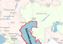
Caspian Sea

The Caspian Sea is the world's largest inland water body (area: 371 thousand km²). It is called the sea, not the lake, since the ancient Romans who arrived in this region discovered that its water was salty, and named the sea after the Caspian tribes who lived near the shores of the lake. The Caspian Sea is bordered by the following five countries: Russia, Kazakhstan, Turkmenistan, Azerbaijan and Iran. The main river feeding the lake is the Volga, which provides about 80% of the inflow of water from the Caspian Sea, and the remaining 20% \u200b\u200bcomes from other smaller rivers.
The Caspian Sea is rich in oil and natural gas deposits, but the production of these is under development. The mining process is also hampered by the problem of dividing the natural resources of the lake between the five countries bordering it. The Caspian Sea and the deltas of the rivers flowing into it are inhabited by about 160 species and subspecies of fish from 60 genera. About 62% of the species are endemic.
Baikal


Baikal is the deepest (1642 m), oldest (25-35 million years) and the most voluminous (23.6 thousand km³) of all lakes in the world; it is a superstar reservoir in the field of hydrology, geology, ecology and history. Today Lake Baikal contains about 20 percent of the fresh water on the Earth's surface, which is comparable in volume to the entire Amazon River basin. Baikal has 27 islands, including one more than 70 km long (Olkhon Island).
More than 1,500 animal species inhabit the shores of the lake, 80% of which are not found anywhere else on the planet. The most famous representative of the Baikal fauna is the seal, which lives exclusively in fresh water. According to some reports, the population of seals is about 100,000 individuals. Also near the lake there are such large predators as wolves, which occupy the upper positions of the Siberian food chain, feeding on deer, birds, rodents and smaller predators.
Ladoga lake


Lake Ladoga is the largest freshwater lake in Europe, located in the northwest of Russia, 40 km east of St. Petersburg. The lake area is 17.87 thousand km², the volume is 838 km³, and the maximum depth at a point west of the island of Valaam it reaches 230 m.
The depression of the lake appeared under the influence of glaciers. The northern shores are mostly high and rocky, and are also divided by deep, ice-covered bays. The southern shores have many sandy or rocky beaches, mostly low, slightly concave, overgrown with willow and alder. In some places there are ancient coastal embankments covered with pine trees. The largest tributaries are the Volkhov, Svir and Vuoksa rivers.
There are 48 different fish species found in the lake, of which the most common are roach, carp, bream, pike perch, perch and smelt. Of the 48 species, 25 are of commercial importance and 11 are in the important commercial fish category.
Lake Ladoga also serves as a key stopping point for migratory birds of the North Atlantic Flyway, which usually mark the arrival of spring.
Onega lake


Lake Onega is the second largest lake in Europe, located in the northwest of European Russia, between Lake Ladoga and the White Sea. It covers an area of \u200b\u200b9.72 thousand km², 248 km in length and up to 83 km in width. The greatest depth is about 127 m.
The basin of the lake was formed by the movement of the earth's crust and glaciers. The high rocky shores in the north and northwest are composed of layered granite and are covered with forest. There are deep bays in Petrozavodsk, Kondopoga and Pevenets. The southern shores are narrow, sandy, often swampy or flooded. Lake Onega has about 1,650 islands, covering a total of about 260 km², usually in the northern and northwestern bays.
The lake is home to over 40 species of fish, including vendace (a small member of the salmon family), smelt, burbot bream, pike, perch, roach, and salmon. Many types of fish have significant economic value.
Taimyr


Taimyr is the second (after Baikal) largest lake in the Asian part of Russia, located in the central regions of the Taimyr Peninsula. It is located south of the Byrranga mountains, in the zone.
The lake and tundra area is a popular destination for birds such as geese, swans, ducks, uphill buzzard, peregrine falcon and snowy owls. Lake Taimyr is home to a large number of fish, including grayling, muksun, char and whitefish. Although the area is relatively remote, there is still a depletion of stocks of certain commercial fish species.
Taimyr is famous for the largest population of reindeer in Eurasia. Also in this region are found such animals as argali, arctic fox, wolf and lemmings. In 1975 the area was re-entered.
The lake and its surroundings have been included in the Taimyr nature reserve since 1983. Scientists have discovered plutonium in the sediments of the lake, which allegedly entered Taimyr through wind-carried radioactive particles after nuclear tests carried out on Novaya Zemlya during the Cold War.
Hanka


Lake Khanka has an area of \u200b\u200b4 thousand km², of which approximately 97% is located in Russia. The maximum depth of the lake is 10.6 m, and the average volume is 18.3 km². The lake is fed by 23 rivers, 8 of which are in China, and the rest in the Russian Federation. The only outflow is the Sungacha River, which flows east to the Ussuri River, which forms the international border, and rushes north to the Amur River.
Khanka is famous as the home of the highest variety of birds in the entire temperate zone of Eurasia. At least 327 species of nesting, wintering and migratory birds were observed in the lake area.
Peipsi-Pskov lake


Lake Peipsi-Pskov is the largest transboundary and the fifth (after Ladoga, Onega, Swedish Venern and Finnish Saimaa) largest lake in Europe, located on the border between Estonia and Russia. It occupies 3.6% of the total area of \u200b\u200bthe Baltic Sea basin. A total of 30 islands are located on Lake Peipsi, and another 40 in the Velikaya River delta. Most of them rise only 1-2 meters above the water level, and often suffer from floods.
About 54 species of coastal aquatic plants grow in the basin of Lake Peipsi-Pskov, including reeds, calamus, reeds and various grasses. The waters of the lake are inhabited by 42 fish species, such as smelt, vendace, bream, perch, pike, roach and whitefish. Wetlands serve as important nesting and feeding grounds for migratory birds such as swans, geese and ducks, which migrate from the White Sea to the Baltic Sea. The region is home to one of the largest swallow colonies in Estonia.
Ubsu-Nur


Ubsu-Nur is the largest lake in Mongolia in terms of surface area (3.35 thousand km²), as well as the largest salt lake in the country. The Ubsu-Nur basin is one of the most important biodiversity poles in Eurasia. Although most of the lake is located in Mongolia, its northeastern shores are located in the Tyva Republic of the Russian Federation.
The lake is shallow, very salty, and is the remnant of a large sea that existed several thousand years ago. The basin covers an area of \u200b\u200babout 70 thousand km² and is one of the best preserved natural steppe landscapes on the continent. It is here that the northernmost part of the desert and the southernmost part of the tundra meet.
Reed and freshwater river deltas serve as resting and nesting sites for numerous migratory birds. More than 220 bird species can be found around the lake, including the black stork, osprey, white-tailed eagle, whooper and black-headed gull. About 29 different fish species live in the waters of the lake, one of which is fit for human consumption. The mountainous region is home to Mongolian gerbils, wild sheep and Siberian ibex.
Vats


Although Lake Chany is not well known outside Siberia, it is one of the largest lakes in the country. Chany is a shallow lake with salty and constantly fluctuating water, the level of which can change from season to season and from year to year. The lands of the lake basin serve as pastures for cattle.
Vats play an important role in the region's fisheries. The most common species are silver carp, carp, ide, and perch. Recently, there has been a tendency for the depletion of fish stocks in the lake.
Lake White


By area, Beloe is the second (after Onega) natural lake in the Vologda region, and the third (after the Rybinsk reservoir). It is one of the ten largest natural lakes in Europe. The lake has a relatively circular shape with a diameter of 46 km. Its area is 1.29 thousand km², and the basin area is about 14 thousand km².
The lake is famous for its fish stocks, the most famous delicacy is Belozersky smelt. The food supply and high oxygen levels create favorable conditions for the life of many species. The following fish species are common in the waters of the lake: perch, pike, bream, ruff, sabrefish, roach, bleak, burbot, chub, rudd, whitefish, ide, tench, asp, dace and gudgeon).
Table of the 10 largest lakes in Russia
| Lake name | Area, km² | Volume, km³ | Dimensions, km | Maximum depth, m | Average depth, m |
| Caspian Sea | 371000 | 78200 | 1200 to 435 | 1025 | 208 |
| Baikal | 31722 | 23615 | 636 by 79.5 | 1642 | 744,4 |
| Ladoga lake | 17870 | 838 | 219 to 125 | 230 | 46,9 |
| Onega lake | 9720 | 285 | 248 to 83 | 127 | 30 |
| Taimyr | 4560 | 12,8 | - | 26 | 2,8 |
| Hanka | 4070 | 18,3 | 90 to 45 | 10,6 | 4,5 |
| Peipsi-Pskov lake | 3555 | 25 | width 50 | 15 | 7,1 |
| Ubsu-Nur | 3350 | 35,7 | 85 to 80 | 20 | 10,1 |
| Vats | 1400-2000 | - | 91 to 88 | 7 | 2,1 |
| White lake | 1290 | 5,2 | 46 to 33 | 20 | 4 |
Russia is a country with rich and unique natural resources, it has something to surprise and amaze: forests, rivers, fields, and of course its lakes, which are also called "blue eyes of our planet", which is undoubtedly very beautiful and poetic. On its territory of the Russian Federation there are about two million lakes, their total area is 350 thousand km 2, the volume of water in all lakes is more than 26 thousand m3. Most of the lakes are of glacial origin.
Large lakes of Russia
The largest lakes located in the European part of Russia are Onega, Ladoga, Chudsko-Pskov, Ilmen, a huge number of lakes in the "lake edge" of the Republic of Karelia.
The lakes of the Asian part of Russia are the Caspian Sea-Lake, Baikal, the northernmost lake of Russia Taimyr, the Far Eastern Lake Khanka and the salt lake Chany in the southwest of Siberia.
The Caspian Lake is the largest drainless, closed body of water on Earth, its area is 371 thousand km 2, and the level is 28 meters below sea level (in Russia it is the Baltic Sea). Due to the large size and specific structure of the bed (it contains the earth's crust of the oceanic type), it is also called the sea. The conditional border between Europe and Asia runs along its surface, it washes the shores of Russia, Azerbaijan, Kazakhstan, Turkmenistan and Iran. The Russian Caspian Sea is the territory of the Republic of Dagestan, Kalmykia, the Astrakhan region (northern and northwestern part of the Caspian Sea) ...
Lake Baikal is one of the most picturesque places in our country, it is the deepest lake on the planet; huge reserves of fresh water are stored here - 85% of all reserves in Russia and 22% of the world. Its area is 31.7 thousand km 2, length - 636 km, width 48 km, maximum indicators of the bay - 1637 m.Baikal is an ancient lake, it is about 30 million years old, its basin is located in a rift depression, its water is particularly clean and transparency, the area around the lake (mountains, hills, dense deciduous forests) - unique picturesque ...
The northern and eastern shores of Lake Ladoga are located on the territory of the Republic of Karelia, the southern and western ones are located in the Leningrad region. Its area, together with the islands - 18.3 thousand km 2, is the largest freshwater lake in Europe. It has access to the Atlantic Ocean, more than 40 rivers and lakes flow into it, the Neva River flows out (it flows into the Gulf of Finland of the Baltic Sea, which is part of the Atlantic). In the southern part there are three large bays, large cities on its coast - Priozersk, Shlisselburg, Novaya Ladoga (Leningrad Region), Sortavala, Lakhdenpohja (Karelia) ...
Lake Onega is located in the northwest of Russia, 80% of it is located on the territory of the Republic of Karelia, 20% - in the Leningrad and Vologda regions. Its area, together with the islands - 9.7 thousand km 2, is the second largest freshwater lake in Europe. The lake basin is located at the junction of the Baltic shield and the Russian platform. About 50 rivers flow into the lake, one flows out - the Svir. Kondopoga, Petrozavodsk, Medvezhyegorsk (Republic of Karelia) were erected on its banks ...
Lake Taimyr with an area of \u200b\u200b4.5 thousand km 2 is called the “northern brother” of Baikal, because it is the second largest freshwater lake in the Asian part of Russia. It is located on the Taimyr Peninsula in the Krasnoyarsk Territory of the Russian Federation. The lake is located in the Arctic Circle, its surface is covered with ice from September to July. The Upper Taimyr flows into it, the Lower Taimyr flows out (the basin of the Kara Sea) ...
At the word "lake" we all imagine a kind of quiet body of water, surrounded by a visible line of the coast. There will be no such lakes in this article. Have you ever heard of lakes that have storm surges and are larger than some seas?
I present to your attention a selection of "the largest lakes in the world", which includes the 10 largest lakes. Read, rate, leave comments and feedback in discussions.
Sasha Mitrakhovich 22.03.2016 15:06

The largest lake in the world - Caspian Sea.
The Caspian Sea tops the rating - despite being called a sea, it is actually the largest closed lake on the planet. It is located at the junction of Europe and Asia, and is called the sea only because of its size. The Caspian Sea is a closed lake, and its water is salty, from 0.05 5 near the mouth of the Volga to 11-13 — in the southeast.
The Caspian Sea is similar in shape to the Latin letter S, its length from north to south is about 1200 kilometers, from west to east - from 195 to 435 kilometers, an average of 310-320 kilometers.
The Caspian Sea is conventionally divided by physical and geographical conditions into 3 parts - the North Caspian, the Middle Caspian and the South Caspian. The conditional border between the North and Middle Caspian runs along the line Chechen (island) - Tyub-Karagan Cape, between the Middle and South Caspian - along the line Zhiloy (island) - Gan-Gulu (cape). The area of \u200b\u200bthe North, Middle and South Caspian is 25, 36, 39 percent, respectively, of the total area of \u200b\u200bthe Caspian Sea.
The length of the coastline of the Caspian Sea is estimated at about 6500 - 6700 kilometers, with islands - up to 7000 kilometers. The shores of the Caspian Sea in most of its territory are low and smooth. In the northern part, the coastline is cut by water channels and islands of the Volga and Ural deltas, the banks are low and swampy, and the water surface is covered with thickets in many places.
The east coast is dominated by limestone shores adjacent to semi-deserts and deserts. The most winding shores are on the western coast in the area of \u200b\u200bthe Absheron Peninsula and on the east coast in the area of \u200b\u200bthe Kazakh Bay and Kara-Bogaz-Gol.
The territory adjacent to the Caspian Sea is called the Caspian region.

Water area and volume Caspian Sea varies significantly depending on fluctuations in water level. With a water level of 26.75 m, the area is approximately 371,000 km square kilometers, the volume of water is 78,648 cubic kilometers, which is approximately 44 percent of the world's lake water reserves. The maximum depth of the Caspian Sea is in the South Caspian depression, 1025 meters above its surface. In terms of maximum depth, the Caspian Sea is second only to Baikal (1620 m) and Tanganyika (1435 m). The average depth of the Caspian Sea is 208 meters. At the same time, the northern part of the Caspian is shallow, its maximum depth does not exceed 25 meters, and the average depth is 4 meters.
Sasha Mitrakhovich 22.03.2016 15:19

In second place among the firmly entrenched lake Superior - the largest, deepest and coldest of the Great Lakes and, in combination, the largest freshwater lake in the world.
In the north, Lake Upper is bounded by the Canadian province of Ontario, in the west by the US state of Minnesota, in the south by the states of Wisconsin and Michigan.
The depressions of the lake in the Upper and northern parts of Lake Huron were mined in the crystalline rocks of the southern part of the Canadian Shield, the depressions of the remaining lakes - in the thickness of limestones, dolomites and sandstones of the Paleozoic of the North American Platform. The basin of the Upper Lake was formed as a result of tectonic movements, preglacial river and glacial erosion.

The origin of the water mass of Lake Upper is associated with the melting of the ice sheet, during the retreat of which a number of large lakes were formed in this area, which repeatedly changed their shape.
In the northern part of the Great Lakes, the coastline is dissected, the islands and shores (altitude up to 400 m) are rocky, steep, very picturesque, especially the shores of Lake Upper and northern parts of Lake Huron.
Fluctuations in the level of the Upper Lake are artificially regulated for the purposes of shipping, energy, etc. The amplitude of seasonal fluctuations is 30-60 cm, the highest level is observed in summer, the lowest - in winter. Short-term level fluctuations caused by strong surge winds and seiches reach 3-4 m, tide heights 3-4 cm
Sasha Mitrakhovich 22.03.2016 15:26

Lake Victoria closes the top three - a lake in East Africa, in Tanzania, Kenya and Uganda. Located in the tectonic trough of the East African Platform, at an altitude of 1134 m.It is the 2nd largest freshwater lake in the world after Lake Superior and the largest lake in Africa

The lake was discovered and named after Queen Victoria by the British traveler John Henning Speke in 1858.
Square lake Victoria 68 thousand sq km, length 320 km, maximum width 275 km. It is part of the Victoria Reservoir. Many islands. The high-water Kagera river flows in, the Victoria-Nile river flows out. The lake is navigable, the locals are engaged in fishing on it.
The northern coast of the lake crosses the equator. The lake with a maximum depth of 80 m is considered to be a fairly deep lake.
Unlike its deep-sea neighbors, Tanganyika and Nyasa, which lie within Africa's gorge system, Lake Victoria fills a shallow depression between the east and west sides of the Great Gorge Valley. The lake receives a huge amount of water from the rains, more than from all its tributaries.
The lake is home to 30 million people. The Khaya people live on the southern and western shores of the lake, who knew how to grow coffee long before the arrival of Europeans. The main ports are: Entebbe (Uganda), Mwanza, Bukoba (Tanzania), Kisumu (Kenya), off the northern coast of Kampala, the capital of Uganda.
Sasha Mitrakhovich 22.03.2016 15:30

Lake Huron is the fourth largest among. It is a lake in the United States and Canada, one of the North American Great Lakes. Located east of Lake Michigan, connected to it by the Mackinac Strait. From the point of view of hydrography, Michigan and Huron form a single system (they are connected by the Mackinac Strait), but geographically they are considered to be separate lakes.

The area of \u200b\u200bHuron is about 59.6 thousand square kilometers (the second largest among the Great Lakes). The surface height above sea level is about 176 m (like Michigan), the depth is up to 229 m.
The states of Michigan and the Canadian province of Ontario have access to the lake. The main ports on Huron are Saginaw, Bay City, Alpina (USA) and Sarnia (Canada).
The name of the lake, introduced into everyday life by the French, comes from the name of the Indian tribe of the Hurons. Manitoulin is located on Huron - the largest island in the world, located in a freshwater lake.
Sasha Mitrakhovich 22.03.2016 15:37

In the middle of the list, in 5th place among lake Michigan - one of the North American Great Lakes.
The only Great Lakes located entirely in the United States. It is located south of Lake Superior, connected to Lake Huron by the Mackinac Strait, with the Mississippi River system - by the Chicago-Lockport Canal.
From the point of view of hydrography, Michigan and Huron form a single system, but geographically they are considered to be separate lakes.

Square Michigan - about 57,750 km2 (the third largest among the Great Lakes), about 500 km long, about 190 km wide. The surface height above sea level is 177 m (like that of Huron), the depth is up to 281 m. It is covered with ice for about four months a year. Islands - Beaver, North Manitou, South Manitou.
The states of Michigan, Indiana, Illinois and Wisconsin have access to the lake. Major cities on Lake Michigan include Chicago, Evanston and Highland Park (Illinois), Milwaukee and Green Bay (Wisconsin), Gary and Hammond (Indiana).
The name of the lake comes from the word mishigami, which means "big water" in the language of the Ojibwa Indians. The first Europeans to discover the lake in 1634 was the Frenchman Jean Nicollet.
Sasha Mitrakhovich 22.03.2016 15:42

The sixth among is Aral Sea.
The Aral Sea is an endless salt lake in Central Asia, on the border of Kazakhstan and Uzbekistan. Since the 1960s of the XX century, the sea level (and the volume of water in it) has been rapidly decreasing due to the withdrawal of water from the main feeding rivers of the Amu Darya and Syr Darya for irrigation purposes. Before the shallowing began, the Aral Sea was the fourth largest lake in the world.
Collector-drainage water flowing from the fields into the bed of the Syr Darya and Amu Darya caused deposits of pesticides and various other agricultural pesticides, appearing in some places on 54 thousand square kilometers of the former seabed covered with salt. Dust storms carry salt, dust and toxic chemicals up to 500 km away. Sodium bicarbonate, sodium chloride and sodium sulfate are airborne and destroy or retard the development of natural vegetation and crops. The local population suffers from a high prevalence of respiratory diseases, anemia, cancer of the larynx and esophagus, as well as digestive disorders. Liver and kidney diseases and eye diseases have become more frequent.

In 2001, as a result of a drop in the water level, Vozrozhdenie Island was connected to the mainland. On this island, the Soviet Union tested bacteriological weapons: pathogens of anthrax, tularemia, brucellosis, plague, typhoid, smallpox, as well as botulinum toxin were tested here on horses, monkeys, sheep, donkeys and other laboratory animals. This is the reason for fears that the deadly microorganisms survived, and infected rodents could become their spread to other regions.
According to the calculations of scientists, it is already impossible to save the Aral Sea. Even if we completely abandon the withdrawal of water from the Amu Darya and Syr Darya, then the previous water level in it will be restored no earlier than in 200 years.
The Aral Sea once occupied 68 thousand square kilometers and was the fourth largest in the world. Now its area is about 10% of that recorded in the 60s of the last century. Pictures from 1989 and 2003:
From the 1950s to the present, projects have been repeatedly proposed for the construction of a canal for transferring water from the Ob basin to the Aral Sea basin, which would significantly develop the Aral Sea economy (in particular, agriculture) and partially revive the Aral Sea. Such construction will require very large material costs (from several states - Russia, Kazakhstan, Uzbekistan), so there is no talk of the practical implementation of these projects yet.
Some scientists predict the complete disappearance of the Aral Sea by 2020 ...
Sasha Mitrakhovich 22.03.2016 15:47

Lake Tanganyika Is a large lake in Central Africa. This is one of and is just as ancient in origin. In terms of volume and depth, Tanganyika ranks second after Lake Baikal. The shores of the lake belong to four countries - the Democratic Republic of the Congo, Tanzania, Zambia and Burundi.
The lake is about 650 km long and 40-80 km wide. The area is 34 thousand sq. Km. Lies at an altitude of 773 meters above sea level in the tectonic depression of the East African Rift Valley. Coastal landscapes, as a rule, are huge rocks and only on the eastern side of the coast are gentle. On the west coast, the steep sidewalls of the East African Rift Zone, which form the coastline, reach 2,000 m in height. The coastline is dotted with bays and bays. The largest of these is Burton Bay. The lake is fed by several tributaries. The only outflowing river - Lukuga (Lukuga) begins in the middle part of the western coast and flows westward, connecting with the Zaire River, which flows into the Atlantic.

The lake is home to hippos, crocodiles, and many waterfowl. Fishing and shipping are well developed.
The antiquity of the lake and the long period of isolation ended with the development of a large number of endemic organisms, including those from the Cichlidae family (cichlids). Of the more than 200 fish species found in the lake, about 170 are endemic.
Tanganyika is inhabited to a depth of 200 m, below this mark there is a high concentration of hydrogen sulfide and life is absent to the very bottom. This layer of the lake is a huge "burial ground" consisting of organic silt and sedimentary mineral compounds.
The temperature of the Tanganyika water is strictly different by layers. So, in the upper layer, the temperature ranges from 24 to 30 degrees, with a decrease at great depths. Due to the different density of water and the absence of a bottom current, the layers do not mix, and the temperature at the lower horizons reaches only 6-8 degrees.
The depth of the temperature jump layer is about 100 m. The Tanganiki water is very transparent (up to 30 m). A lot of salts are dissolved in it in small concentrations, so that in its composition it resembles a highly diluted sea salt. Water hardness (mainly due to magnesium salts) ranges from 8 to 15 degrees. Water has an alkaline reaction, pH 8.0 - 9.5.
There are about 5 million lakes in the world, but we have only heard of a few of the largest. Do you think that Baikal is the largest lake in the world? In fact, Baikal is only 7th in the ranking of the largest lakes!
Did you know that the area of \u200b\u200bthe largest lake on the planet is equal to the area of \u200b\u200b52 million football fields and is comparable to the area of \u200b\u200bMoscow multiplied by 150 times? No? Then read below!
No. 10. Big Slave Lake - 28,930 square kilometers. North America.
The Great Slave Lake is the 10th largest lake in the world, and it is also the deepest lake in North America. Its depth is 614 meters. The dimensions of the Great Slave Lake: 480 km in length, 19-109 km in width, and an area of \u200b\u200b28,930 square kilometers.
From October to June, the lake is frozen, and in winter the ice can support the weight of trucks. Rivers flowing into the lake: Hay, Slave, Snowdrift, etc. The Mackenzie River flows out of the lake. The origin of the lake is glacial-tectonic.


No. 9. Lake Nyasa - 30,044 square kilometers. East Africa.
Lake Nyasa (Malawi) is the ninth largest lake in the world. Lake Nyasa fills a crack in the earth's crust in the Great Rift Valley in East Africa, located between Mozambique and Tanzania. The length of the lake is 560 km, the depth is 706 m. Nyasa contains 7% of the world's reserves of liquid fresh water.
Nyasa is known for its rich ecosystem, many of the species found in the lake are endemic. The origin of the lake is tectonic.


No. 8. Big Bear Lake - 31,080 square kilometers. Canada.
Big Bear Lake is located 200 km south of the Arctic Circle in Canada. The lake is the eighth largest lake in the world and the fourth largest in North America. Dimensions of the lake: length - 320 km, width - 175 km, maximum depth - 446 m.
The lake has not a very good history. Uranium was found here. It was from here that uranium was mined for the manufacture of bombs dropped on Hiroshima and Nagasaki. The lake is almost always frozen, the ice rarely melts before the end of July. The origin of the lake is glacial-tectonic.


No. 7. Lake Baikal - 31,500 square kilometers. Eastern Siberia.
Baikal is the deepest lake in the world, the largest water reservoir, which contains 20% of the world's liquid fresh water. Baikal is also considered one of the cleanest lakes in the world.
The lake ranks seventh in area in the world and first in volume. Dimensions of the lake: length - 636 km, width - 80 km, maximum depth - 1642 m, volume - 23 600 km3.
The origin of the lake is tectonic, more than 25 million years old. The fauna of Lake Baikal is one of the most unique in the world, many species are endemic.


No. 6. Lake Tanganyika - 32,893 square kilometers. Central Africa.
Lake Tanganyika is one of the deepest lakes in the world, along with Lake Baikal. The lake lies between 4 countries - Democratic Republic of Congo, Tanzania, Zambia and Burundi.
Dimensions of the lake: length - 676 \u200b\u200bkm, width - 72 km, maximum depth - 1470 m, volume - 18,900 km3. The origin of the lake is tectonic.
Tanganyika lies in the deepest tectonic depression in Africa and is part of the basin of the Congo River, one of the largest rivers in the world.


No. 5. Lake Michigan - 58,016 square kilometers. North America.
Lake Michigan is one of the Great Lakes. This lake is the largest of the lakes entirely located in the United States. Michigan is the fifth largest in the world and the third largest in the Great Lakes. The volume of the lake is 4918 m3, length - 494 km, width - 190 km, maximum depth - 281 m. The origin of the lake is glacial-tectonic.


No. 4. Lake Huron - 59,596 square kilometers. North America.
Lake Huron is one of the Great Lakes. This lake is located on the territory of two countries: the USA and Canada. Huron is the fourth largest lake in the world. The volume of the lake is 3538 m3, length - 331 km, width - 295 km, maximum depth - 229 m. The origin of the lake is glacial-tectonic.


No. 3. Lake Victoria - 69,485 square kilometers. East Africa.
Lake Victoria is located in Tanzania, Kenya. After the construction of the Owen Falls Dam in 1954, the lake was converted into a reservoir. There are many islands on the lake. Fishing is developed on the lake and there are many ports in the three countries. On the island of Rubondo (Tanzania), a national park was formed.
Victoria is the third largest lake in the world. The volume of the lake is 2760 m3, length - 320 km, width - 274 km, maximum depth - 80 m. The origin of the lake is tectonic.
The lake was discovered and named after Queen Victoria by the British traveler John Henning Speke in 1858.


# 2. Lake Superior - 82,414 square kilometers. North America.
Lake Superior is the second largest lake in the world and the largest of the Great Lakes, located on the border of the United States and Canada. The volume of the lake is 12,000 m3, length - 563 km, width - 257 km, maximum depth - 406 m. The origin of the lake is glacial-tectonic.
Etymology of the name. In the Ojibwe language, the lake is called Gichigami, which means "big water".


# 1. Caspian Sea - 371,000 square kilometers. Europe Asia.
The Caspian Sea is the largest enclosed body of water on Earth and is classified as the largest lake or sea because of its size. Located on the knock of Europe and Asia. Volume - 78,200 m3, length - 1200 km, width - 435 km, maximum depth - 1025 m. The length of the coastline of the Caspian Sea is approximately 6,500 kilometers.
130 rivers flow into the Caspian Sea, the largest of them are the Volga, Terek, Sulak, Ural, Kura, Artek and others. The Caspian Sea washes the shores of Kazakhstan, Iran, Turkmenistan, Russia, Azerbaijan.
The origin of the lake is oceanic.


About tourism
TOP Russian lakes with unusual names
Russia can be safely called a lake land. Of course, there are countries with a large number of freshwater bodies of water, but for a Russian, nothing can be more beautiful than their native open spaces. In addition, almost all of our lakes bear original, distinctive names.
Gechepsin. This lake is located in the Crimean region of the Krasnodar Territory, in the Lefkadia valley. Translated from the Adyghe, this reservoir is called "a well, the water in which is suitable for washing." Why such a name was chosen - history is silent. We can only make assumptions. So, the water in the lake could be soft and clean, or "Gechepsin" was specially created for various bath procedures.

"Dead Lake". In the southern part of Eastern Siberia, in the vicinity of Lake Baikal, there is the Dead Lake. This is a reservoir with clean water, but no one swims there, because it is mostly swampy, and its banks are mostly peaty and unsteady. Also, this lake has another name - "Warm Lake". It's all about the gas, the bubbles of which rise from the bottom to the surface.

"Mortal Lake". "Smerdyachye Lake" is located in the Shatura District of the Moscow Region. The reservoir got its name for the characteristic smell of hydrogen sulfide. In 1985, a hypothesis was put forward about the meteoric origin of the lake, which was later confirmed. According to scientists, the meteorite that formed the "Mortal Lake" collided with the Earth about 10 thousand years ago.

"Svetloyar". To see Lake Svetloyar, you need to get to the Voskresenskiy District of the Nizhegorodskaya Oblast. According to legend, it is under the water of this reservoir that the magical city of Kitezh is hidden. Only the righteous, bright people, are worthy to hear this holy city. They say that from the bottom of the "Svetloyar" sometimes a hum can be heard, similar to the ringing of bells.

Tsagan-Khag.This lake is located in the Republic of Kalmykia. Its name is translated from Kalmyk as "white silt". Most likely, there is no legend here, there are observations. Tsagan-Khag is located on a saline site and periodically dries up. It was during these periods that white salt forms on the surface of the reservoir, which in ancient times was most likely mistaken for silt.

Lake "Boiling". On Sakhalin, on the Kunashir Island, there is the Boiling Lake. According to legend, this reservoir was formed as a result of a volcanic explosion. The name "Boiling" lake is due to the fact that its water is heated by volcanic gases. Here you can often observe salvo emissions of boiling water, which are echoed by jets of sulfur and hydrogen sulfide gases.

"Bottomless Lake". It would seem that there is nothing easier than measuring the depth of the lake. However, not in the case of "Bottomless Lake", the depth of which is still unknown. Hence the name. This reservoir is located in the suburbs, near the Vertlinskoe highway. Another feature of the "Bottomless Lake" is that it does not have solid shores (they can only swim from the pier), but, nevertheless, it never changes its rounded shape.