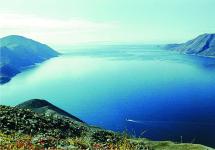
Fisht is a mountain in the western part of the Main Caucasian ridge, height - 2867 meters. Fisht is the westernmost peak of the Caucasus, with glaciers on its slopes: the Big and Small Fishtinsky glaciers. In ancient times, the mountain was an island in the Tethys Ocean, which explains its coral structure.
You are expected by:
- Stunning nature of the Western Caucasus: nature reserves, rocks, beech forests, alpine meadows, mountain streams, snowfields and glaciers
- The opportunity to become a real climber - walking in the snow with an ice ax, wearing a helmet and crampons, rattle with carbines and use the climbing system
- Climbing the first serious mountain peak
- New friends and soulful evening gatherings
- Delicious and varied food from our guide
Route details:
- Minimum fitness level: good physical shape
- Accommodation: campground
- Meals: 3 meals a day (hot breakfast and dinner + rations for lunch and a snack to go)
- Maximum number of people in a group: 14
14,000 rubles
10 days, 70 km, difficulty: HighInterested in tourists who have already passed some.
Fisht is one of the most grandiose and famous peaks of the Western Caucasus. It is the highest point of the Fisht-Oshten massif. The mountain is located in the western part of the Main Caucasian ridge, in Adygea. Fisht's height reaches 2867 meters. On the northern slope of the mountain lies the largest glacier of the Lagonaki Upland - the Big Fishta Glacier. Its length is 1.2 kilometers. Climbing Fisht is an addition to the legendary "Thirty" hike, known to all mountain hikers since the times of the USSR. This is a classic climbing ascent of an entry level of difficulty (category 1B). It can be mastered by both experienced tourists and physically prepared beginners.
Our way to Mount Fisht will pass along the famous tourist route No. 30, laid through the picturesque Caucasian reserve with access to the Black Sea in the Sochi region. In this hike, we will be able not only to enjoy the picturesque views of Adygea, but also to conquer a real peak, to get basic climbing skills. At the top of Fisht, we will see incredibly beautiful mountain panoramas, which will take our breath away. On the last day of the hike, we will have a rest on the coast of the warm sea.
V hike "Thirty" with an ascent to Fisht there will be no difficult category passes. However, climbing to the top requires from the participants physical fitness not lower than the average level.
Trekking route:
Krasnodar - Lagonaki checkpoint - Kurdzhips river - Glubokaya Balka gorge - Armenian river - Oshten mountain - Pseno-Dakh lake - Fisht shelter - Fisht mountain - Belorechensky pass - Cherkessky pass - Babuk Aul village - Solokh Aul village - Dagomys
Day hike program
Day 1... Arrival in Krasnodar, transfer to the Lagonaki plateau (1820 m)


The meeting of the group takes place at the railway station of Krasnodar. After meeting we will move to the Lagonaki plateau. Upon arrival, we will go down to the Kurdzhips river. We will set up our camp on the left bank of the river in a forest with 40-meter fir trees. After lunch we will swim in a mountain river with clear water.
Day 2... Radial hike to the Glubokaya Balka gorge, visiting the Mezmayskaya cave.


After breakfast we will make a radial hike without backpacks to the Glubokaya Balka gorge. In the rocks of the gorge, the Mezmayskaya cave is hidden - one of the amazing caves in the Western Caucasus. We will visit all of its truly fantastic halls, the hall of balls and snakes. After visiting the cave, we will go to the camp. We will walk 16 kilometers in a day.
Day 3... Trekking to the foot of Mount Oshten (1952 m)


In the morning, we will make a six-kilometer trek to the sources of the Armenianka River. This place is located at an altitude of almost 2000 meters above sea level, at the foot of Mount Oshten. Here, the forest zone has already been replaced by a zone of alpine meadows, so we will have to do without a fire and cook dinner on a gas burner.
Day 4... Climbing Mount Oshten (2804 m)


Early rise, breakfast, and we begin our ascent to Oshten. This mountain is one of the safest and most accessible peaks in the Western Caucasus. At the top of Oshten, we will see beautiful panoramas of mountains and valleys. After resting, we will return to the camp.
Day 5... Trekking to the Fisht shelter (1580 m)


In the morning we will have a quick breakfast and pack up the camp to make the transition to the Fisht shelter. We will slightly change the classic route and go there not through the Guzeripl pass, but through the Fisht-Oshtenovsky pass. This route is more than one kilometer, but it's worth it, because on the way we will go to Lake Pseno-Dakh! The water in the lake is very clean, it warms up only by the middle of summer, so swimming is only for daredevils. After lunch, we will continue the traverse of Oshten and after conquering the Fisht-Oshtenovsky pass (2222 m), we will go down to the Fisht shelter.
Day 6... Climbing Fisht (2867 m)


We will wake up at 5.30, have breakfast and boldly go to conquer Fisht. Only 52 meters difference with Oshten, but what a difference! Many obstacles await us: rocks, a large glacier, wind, sun, chamois running along the ridge. At the top, we will admire the views and go down to the shelter. We will visit the bathhouse, cook dinner and start celebrating the conquest of the summit.
Day 7... Trekking to the small Fishta glacier, crossing the Belorechensky pass (1782 m) and the Circassian pass (1832 m).


Today we leave the Fisht shelter and go on to the sea. In the morning we will climb the Small Fisht Glacier. Then we will cross the Belorechensky pass. In the afternoon we will walk along a picturesque road through the Circassian Pass. We will reach the shepherd's booths and set up our tents there.
Day 8... Midday. Trek to Babuk-Aul (660m)


In the morning we will have a rest on the shore of a wonderful high-mountain lake. By lunchtime, we will remove the camp and go to the village of Babuk-aul and then to the border of the reserve, where we will set up a camp on the banks of the Shakhe River.
Day 9... Trekking to the village Solokh-aul, moving to Dagomys


After breakfast, we will pack up the camp and go down along the Shakhe River to Solokh-aul, where we will take a bus that will take us to Dagomys, the resort area of Sochi. A beautiful beach and a gentle warm sea are waiting for us there.
Day 10... Rest at the sea. Departure home.
Another vacation came, and I again go to the mountains. As usual, the hardest part is choosing where to go. I want it everywhere and at once, but it won't work that way. This time I decided to make a combined trip: first, I go alone to the Caucasian State Natural Biosphere Reserve to Mount Fisht, and then I go on a hike across North Ossetia with a group with "Mountain Roads". For a long time I wanted to go to Fisht, but there are no long routes there, 4-5 days maximum, and somehow I didn't want to go just for the sake of such a short hike. At the same time, I did not want to go only on a campaign in North Ossetia. Although Ossetia itself is very interesting to me, but besides this, I still wanted to get tired of the hike, and the route there is still pretty simple. And as a result, the idea was born to combine two such routes in one trip, which I have never regretted.
So, a mini-hike to Mount Fisht.
The main feature: the route passes through the territory of the reserve, and you need to follow the established rules, somehow stop for the night only in equipped parking lots, do not burn fires, do not walk in places that do not belong to permitted tourist routes. For myself, I chose route number 3 from the Lago-Naki checkpoint through the shelter at the foot of Mount Fisht to the village of Solokh-Aul. From the Fisht shelter, I also made a radial ascent to the top of Fisht, and also went to the Fisht-Oshtenovsky pass. For three and a half days I found 78 km, more than 3 km of climb and almost 5 km of drop.
Trekking track:
Trek: 19 km;
Total climb / drop in height: 524 m / 714 m;
Yesterday I spent the whole day trying to get to the village of Kamennomostsky (aka Khadzhokh) in Adygea. The village is already in the mountains. I stayed at the Melnitsa hostel. A good home hostel, cheap, well fed, and even for the same money they settled in a single room instead of an armored bed in a dormitory room. I agreed with the owners to take me to the Lago-Naki cordon the next morning. Public transport, alas, does not go there. They asked for 1,500 rubles. In my opinion, a bit too much, but according to the information that I found on the Internet before the trip, taxi drivers took the same amount.
Drive about 30 km. On the way, we stopped at the Ministry of Emergencies, where I registered my trip. I have never done this before, and even now, generally speaking, I did not intend to, but, they say, the administration of the reserve does not like very much when single tourists do not register with the rescuers. So for their (well, my own, what really) peace of mind, I did it. The Ministry of Emergency Situations, however, made a note to me that they do not recommend this route (they write this to all singles), but they registered it. It works like this: at the end of the hike, I should call the specified phone number. If suddenly I don’t call me back, then on the key date they themselves will start calling me. If I do not answer any of the phone numbers (and they require two different ones), then a rescue squad will come out in search of me. The hike according to the plan ended on the 18th, the control date was set on the 20th.
At the checkpoint "Lago-Naki" I issued a pass to the reserve. I honestly told the employee the entire route, in particular, that I was going to climb Fisht. Before the hike, I still did not understand if the reserve allowed to go there, and decided to find out on the spot. But the guys didn't care, they didn't even reflect this moment in the pass. So, tomorrow I will try to climb to the top! The pleasure of walking around the reserve cost me 1,500 rubles, 300 rubles per day of stay. According to the plan of these days, I had 4, but I decided to pay for one as a spare.
I'm starting!
Left the cordon at 10:30. I walked very easily, I couldn't feel the shallow elevator. By noon I reached the Abadzesh pass. On it, at the monument, I made a halt, rested for half an hour.
A thunderstorm began in the area of the Instructor's gap. It lasted an hour and a half or two with a powerful downpour, hail, hurricane wind and lightning directly overhead. The places were open, and there was nothing to do but walk forward, staring at the path in front of you. Many beautiful places remained unnoticed by me because of this thunderstorm. Stopped watering just before the Armenian Pass. Fisht was at the orphanage at half past four. Before I even had time to put up the tent, it started to rain again, things got a little wet. I had dinner already inside. Set the alarm at 5 am, I'll try to go to Fisht.
 On the Lago-Naki plateau. In the center is Mount Oshten.
 Mount Fisht from the Guzeripl Pass.
Trek: 12 km;
Cumulative climb / drop of altitude: 1226 m / 1226 m;
Evening parking: 1581 m above sea level. m.
Woke up at five, as planned. But ... it rained and thunder rumbled. I decided to lie down and wait until the weather cleared up. The rain stopped at about six, the sky seemed to dissipate, so I started making breakfast and getting ready. I left the camp at 7:30. He simply left the tent along with all his belongings, hoping that there were no criminals there.
 At the Fisht shelter. Pshekha-Su and Oshten mountains and Fisht-Oshten pass. On the left, on the slope, the so-called "Red Rocks", it is under them that the route of climbing Fisht passes.
The standard route for climbing Fisht has been studied by me for a long time, much before I started planning this trip. First, along the trail to the Fisht-Oshten pass, an approach under the "Red Rocks" (it is impossible to confuse that this is impossible, they are too prominent), then an ascent along them to the upper plateau, an approach to the Big Fishtinsky glacier, a glacier crossing, then a rather steep section - exit to the western ridge and finally a simple transition along the ridge to the top. The entire path is well marked, and on the ascent along the Red Rocks in especially steep places there are ropes. The only area where the markings are weak is between the glacier and the Red Rocks. In some places, the markings are not enough (you cannot see the next from one tour), and in some, on the contrary, there are many chaotically arranged tours, because of which it is not clear where the main path is. Apparently, due to insufficient marking, people began to wander there in different directions, and everyone considered it their duty to mark their way, and it only turned out worse.
Well, in order. The ascent along the Red Rocks is quite steep. There he overtook two tourists in motorcycle helmets instead of helmets. I met them yesterday too, overtook them before the Armenian Pass. I didn’t see them again, so, apparently, they didn’t reach the top, but turned somewhere earlier. And it was because of what! At first the weather was good, the sun was shining. But soon, somewhere after the Red Rocks, the sky began to frown, a dense cloud fell on the mountain, visibility deteriorated greatly, a thunderstorm thundered around. However, it was not raining at that moment, so I continued my ascent with the thought that the weather in the mountains changes often and that the sun will be shining soon.
 Red rocks.

I got out onto the glacier. In the navigator, I had a trail drawn along it, but in reality it was not. Traces on the glacier almost do not hold, and after yesterday's thunderstorm, nothing remained at all. In the end, I went my own way, trying to keep the path drawn in the navigator. I have no cats, I walked in the same sneakers. However, the slope here is not very large, and at the bottom the glacier flattens out almost to the horizontal. There are no dangerous cracks either. The surface is rather loose, and it was quite normal to walk in sneakers. At least up. Down will probably be worse, we'll see later.
 Big Fishta glacier.
 On the Big Fishta Glacier, downward view.
Soon after I got to the glacier, the sky finally leaked out and from the cloud that sat on the mountain, heavy hail fell, mixed with rain. Well, in such weather it makes no sense to go to the top for sure. And it's not safe at the top in a thunderstorm. However, at that moment I was in the most interesting place, in the middle of the glacier, where it is not very easy to stand, and there is no place to hide at all. I decided to go further to the place of the ascent to the western ridge, and wait there and watch the changes in the weather. The trail goes across the entire glacier, taking it to the west, bypassing the bergschrundt in its upper part. At the end of the glacier, precipitation ended as ordered, and although it was still cloudy, I decided to continue climbing. The path to the ridge is quite steep, but the markings are excellent. At the top of the ridge, I finally saw the top and the blue sky: finally clearing up! Now we have to go upstairs rather than cover it again. The ridge is rather narrow, with steep cliffs in both directions. However, it is safe to go, the main thing is not to approach the edge. Already at the top I caught up with two elderly tourists, at the top we are together. It took 4 hours to get up from the shelter.
 In the place of the ascent to the western ridge, a view of the glacier.
 On the western ridge. Summit Fisht finally without clouds, hurry there!
Unfortunately, there are almost no views, but we managed to take a few pictures. The height of the summit seems to be 2867, but the navigator did not measure more than 2790. I think because of the bad weather ... 20-30 minutes on top and down. The mood after the top is upbeat. I met three guys on the ridge. They took a burner with them to have tea upstairs, but they forgot the lighter. Gave them mine. By the way, they later returned it to me, which was deserted and not working. And almost at the glacier I met another one of their company. He had been sitting on a stone for about 30 minutes and did not move. He said that he was tired, did not calculate and did not take a snack with him. He asked me for something to eat. I gave him half of the chocolate bar and the rest of the dried apricots. Later I found out that he did come to the top. Apparently it helped :) Descent without crampons turned out to be even easier than ascent. Well, it slips a lot, it is very difficult to deal with it, but it is not so necessary either: since the incline is not very large, I kept sliding on my feet to the very bottom. Fast and efficient.
 On the top!

 Big Fishtinsky glacier from the top of Mount Fisht.
I came back in a different way, from the glacier to the Red Rocks I followed an alternative path to the west. It is also marked, but bad. In the end, it all ended with the fact that I just walked in the right direction, choosing the path myself. In the same place, a thunderstorm began again and did not end until evening. I abandoned all my plans to climb Pshekha-Su as well and just started descending. It was necessary to do it very carefully in such weather, especially along the Red Rocks. The ropes were actually there. I went down to the shelter at 14:40, almost completely drenched (only the membrane jacket works for a five). In total, 9 people were at the summit today. And in clear weather there are probably crowds in general.
Climbing track:
Trek: 28 km;
Cumulative climb / drop: 1053 m / 2280 m;
Evening parking: 361 m above sea level. m.
The plan is to run to the Fisht-Oshten pass in the morning, and after returning to turn off the camp and go to Babuk-Aul. I did not set the alarm, because there should have been enough time in any case. As a result, I was lying around for a long time, until it became terribly hot. The weather is fine today. At least for now. I left only at 9. The pass was not as close as it seemed, and the climb is rather big: 650 meters from the shelter has to be gained. And horizontally 4.5 km somewhere. Climbed up in 1:40. At the pass I sat down to rest. The weather was excellent and I didn't want to go anywhere. As a result, I sat there for 50 minutes.
 The top of the Fisht mountain from the ascent to the Fisht-Oshten pass.
 View from the Fisht-Oshten pass to the Fisht shelter and the Belaya river valley.
Descended quickly. The heat at the shelter, 35 degrees, no less. It does not dispose to activity at all, so the fees were slow and sluggish. I left the shelter only at 13:15. Without rest I reached the Belorechensky Pass. And then the weather once again decided to play a trick on me and out of nowhere gave birth to another thunderstorm on me. As expected, with lightning all around and hail. Hailstones are one centimeter in diameter, they even pierce the hood, open hands also suffer. I had already been on the road for an hour, with an hour of continuous ascent, and felt an urgent need to rest a little. As a result, even despite the storm, almost reaching the saddle, he stopped. But I did not rest for long, after a few minutes I was almost washed away by the river flowing from the saddle of water and hailstones. My backpack and I were abruptly ankle-deep in cold liquid, so I had to move on. As I was later told, in the area of the Belorechensky Pass there are steep views, there is where to walk and what to take pictures. But skipping all the fun is already a tradition of this trip. Well, there will be additional motivation to return :) I slowly reached the Circassian Pass, where local shepherds sell milk-ayran. Soon after, the rain stopped, the sun shone again and it became hot. Oh, this weather!
 Pass Belorechensky. Bad weather again!
Before the "Merry Descent" I caught up with yesterday's acquaintances, with whom I was at the top of Fisht. We sat and rested for about ten minutes, and then said goodbye: they were not going to go to Babuk-Aul, but to get up for the night somewhere earlier. And I ran forward. The descent is really funny: in a short time you lose almost one and a half kilometers in altitude. On the way, I also made a halt at the Kholodny spring. I went to Babuk-Aul at about seven in the evening. A very civilized shelter, there are toilets, showers, awnings and gazebos. It took twenty minutes to light the burner. The lighter did not work after yesterday, and after today the matches got wet, despite the fact that they were in a tied bag. It was necessary to put them in a sealed bag, but I thought they would stay dry anyway. The second box of matches turned out to be completely messy. As a result, I disassembled the lighter and somehow managed to achieve a spark in the piezoelectric mechanism. There is still no telephone connection. And in general, she was nowhere on the route, although the Internet claimed otherwise. I think the weather is to blame, it should be on clear days.
 Cheerful descent.
Trek: 18 km;
Total climb / drop: 473/649 m.
The alarm went off at 7, with the expectation to go out at 8:30. The whole night was cloudy, sometimes it rained. The tent is wet in the morning. I was a little mistaken with the distance that had to be covered that day. The official description stated 7 km to the White Stream checkpoint. And he seems to be on the outskirts of Solokh-Aul. So I decided to get off at 8:30 in order to catch the bus at 10:35 with a margin. Most of the people who spent the night at the shelter ordered transport from the staff of the reserve, so that they would take them, fortunately, there is a road. The road is rather boring, it went quickly. For the first time during this trip, tickets to the reserve were checked at the checkpoint. After the checkpoint, Solokh-Aul did not appear for a suspiciously long time, I decided to look into the navigator. And then there was a surprise: it turns out that there are two White Streams, one at the checkpoint, and the other in Solokh-Aul, and there is more than 10 km between them :) So, I didn't study this part of the route very carefully, and she immediately punished me for it. However, there was no problem as such. Well, I'll catch the next bus at 11:50, no big deal. Came just a few minutes before departure. At the bus stop, I met a whole crowd of tourists, who in the morning were taken from Babuk-Aul here in cars.
This was the end of this mini-trip to the Caucasian reserve. Then I went to Sochi, spent the night in a hostel, and the next day I went by train to Vladikavkaz, because there I have another trip around North Ossetia, only now with a group. There will be a separate story about him.
Well, I really liked this trip. Fisht-Oshten massif is a very cool place. Separately, I am pleased with the successful ascent of Fisht, the most vivid impression of the hike. The routes here are designed for beginners, it is impossible to get lost, and the transitions are quite simple and short. And in general, the place is very popular. At the Fisht shelter, at least a hundred people lived on both days. With the weather, of course, not very lucky. Every day some kind of storm swooped down, wet me to the skin, as a result, there were no dry things :) The humidity is still very high here, so everything did not have time to dry out in between the rains. In general, there is still where to walk here, you can safely return.
More photos from the hike
Krasnodar club of climbers "Striving" invites everyone to ascend to the top of Mount Fisht - the highest point of the Lago-Naki plateau and the entire Western Caucasus.
Weekend ascent through two passes along the unique Lago-Naki upland to the peak Fisht ("White head" - Adyg.) Along the westernmost glacier of the Caucasus. The highland is included in the list of UNESCO World Natural Heritage Sites.
This is one of the most beautiful and famous peaks of the Krasnodar Territory and the Republic of Adygea. In clear weather it is visible from Krasnodar, Slavyansk-on-Kuban, Sochi, Timashevsk, Armavir. Height 2868 m - the highest point of the Lagonaki Upland. Fisht is translated from the Adyghe as "white head". The southern and western walls of the mountain reach 500 - 700 meters in height, on the northern slope lies the Big Fishta glacier (length 1.2 km), on the eastern slope - the Small Fishta glacier, descending to a mark of 1980 m above sea level. Together with the glacier on Mount Pshekho-Su, the Fishta glaciers are the westernmost in the Caucasus. In the northern part of the western wall of Mount Fisht there is a depression - the mouth step of the Hanging Valley. The Vodopadisty stream falls from this step as a majestic waterfall (158 m high). On Fishte there are many caves with significant depths: Krestik-Tourist (650 m), Soaring Bird (535 m), Olga (520 m), Anglo-Russian and others.
Date: June 2-4, 2016
Place: Republic of Adygea, Russia, Maykop district, Lago-Naki plateau.
Participants: all comers are invited to visit!
Availability: you must have an average physical fitness.
Departure (from the club "Aspiration"): June 2 07-00
Return (tentative): June 4 22-00
Price: RUB 7,000
Cost for members of the club "Aspiration": RUB 6,000
Included in the price:
- environmental fee for staying in the reserve (3 days);
- nutrition;
- burner, gas and collective cooking utensils;
- work of an instructor;
- collective equipment for climbing.
NOT included in the price:
- transfer Krasnodar - Yarovaya Polyana - Krasnodar (we leave in our cars, the crews are formed as the group is recruited);
- personal equipment.
EQUIPMENT REQUIRED (can be rented on the recommendation of the instructor):
- trekking or climbing boots;
- safety gazebo and 2 muffled carbines;
- ice ax;
- cats;
- helmet;
- sleeping bag with a comfort temperature of minus 5-8 degrees C;
- a wind and waterproof suit made of a membrane or similar material;
- polar jacket or woolen sweater;
- pants or woolen pants;
- thermal underwear and a hat;
- trekking / ski / burgundy socks;
- a backpack for equipment with a volume of 65-90 liters;
- light thermos or plastic bottle (1 liter);
- ski or trekking poles;
- electric flashlight (better headlamp);
- sunscreen with a protection factor of at least 20 and hygienic lipstick;
- mat;
- tent (one for 2-4 people).
PROGRAM:
Day 1 (Friday)
Transfer Krasnodar - Yarovaya Polyana (1800 m). On the way - to the village. Guzeripl registration of passes to the reserve. Meeting at Yarovaya Polyana at 13.00
Trekking along a path through a reserved beech forest and then along a path among alpine meadows through the Guzeripl and Armenian passes (1868 m). Descent from the pass to the Fisht shelter on the bank of the Belaya river. Setting up a tent camp. Dinner. Evening photo session.
the best season for climbing Fisht
Climbing Fisht from Fishta Shelter along the classic route 1B *, depending on the level of training, weather and the state of the relief, takes from 6 to 12 hours and consists of five sections:
Section 1. Leaving the Fisht shelter (point "1" on the diagram), you need to cross the Belaya river over the bridge, and along its left (orographic) bank along an excellent path, move north towards the Fisht-Oshtenovsky pass. 1.2 km after the shelter, the trail goes to the right bank (small ford over the pebbles) and begins to climb towards Fisht - Oshtenovsky pass. At an altitude of 1800 meters, turn off the path leading to the Fisht-Oshtenovsky pass (point 2) and turn left, towards the couloir to the left of the "Red Rocks". Actually, this section is just an approach to the route, the ascent to Fisht itself begins from this point.
Section 2. Ascent under the Red Rocks to the Pshekha-Su - Fisht saddle (point 3). One of the two most difficult sections of the route. On a short stretch of less than 1 km, you need to gain more than 400 meters of altitude. The movement takes place on grass, small stones. Especially carefully you need to go through this section on the descent, when the accumulated fatigue and possible bad weather makes itself felt.
Section 3. At an altitude of about 2200 meters, the trail opens onto a wide plateau-like saddle between the Fisht and Pshekha-Su peaks. The further 1.5 kilometers of the route to the beginning of the glacier at an altitude of about 2500 meters (point 4) pass along the gently rising slope of Mount Fisht with numerous karst sinkholes, cracks and depressions. In summer, the route is not difficult, in the off-season you should be extremely careful!
Section 4. Key section. Driving along the glacier and climbing the destroyed rocks to the western ridge (point 5). This is the most difficult part of the entire route. The main danger is cracks in the glacier. From July to October, all cracks are open and easy to get around. In the off-season, the cracks are covered with snow and the site is traversed in bundles!
Section 5. Movement along the western ridge (destroyed, not steep rocks) to the top (point 6). The main hazards in this area are strong wind, cold and the danger of a lightning strike in a thunderstorm. Be careful not to go on the route in thunderstorms!
I can recommend an excellent report and description of the ascent route from Alexander Shirokolobov. In it you can find even more details along the route.
Approximate climbing schedule
(for a group in good shape, with stops for rest and photographing)
- rise - 4:00 am
- leaving the camp at the Fisht shelter - 5:30 am
- exit to the glacier - 10:00
- Fisht peak - 11:30 - 12:30