Mountain Digoria is subdivided into Eastern and Western parts. The channel of the main waterway of Digoria - Urukh (Irafa in the Digor manner), which is formed in the upper reaches from the confluence of the Karaugomdon and Khares rivers, is considered to be a conditional border between them. After the confluence with the Karaugomdon River (absolute height 1490 m), flowing out from under the Karaugom glacier, Urukh immediately becomes abundant, increasing in volume by 2.5-3 times. Flowing further along the bottom of the wide Urukh gorge, the Urukh river receives its two largest tributaries: on the left - Bilyagidon, on the right - Aigamugidon. The Urukh plain comes out near the village of Kalukh (absolute height 750 m). Thus, on a relatively small stretch - 20 km, the altitude drop is almost 750 m. You can imagine the speed of the water flow.
The road to the upper reaches of the Digor Gorge is laid along the Urukh River and passes the "gate" of the Alania National Park in the village of Matsuta.
Almost all natural attractions of Western Digoria are located on the territory of the Alania Park, access to which is still free (2016).
Beyond Matsuta, the road turns to the left bank of the Uruh. The valley gradually narrows, the slopes become steeper, a forest appears. The outlines of the surrounding mountains become sharp, the peaks are sharp, rocky, and the slopes become steep and steep.

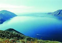
After 6 km from Matsuta we find ourselves in the village of Akhsau, beyond which the Digorskoe gorge becomes wider. From here you can clearly see the entire Urukh gorge - a grandiose trough with a flat wide bottom and steep steep slopes. To the right of the road are the spurs of the Sugan ridge, to the left of the Kazatykhokh massif — two huge links of the Lateral ridge, separated by the transverse valley of the Urukh River. The river flows along a wide bottom, winding and splitting into numerous branches.
The peculiar tricycle (trough-like) shape indicates that it was created not only by the river, but also by an ancient glacier that descended 20-25 thousand years ago from the northern slope of the Main Dividing Range.
Another 4 km of the path, and at the foot of the Chirkh ridge, where the Karaugomdon and Khares rivers merge - the two main sources of the Urukh River, the road bifurcates. On the left, across the bridge along the Karaugomdon River, the road goes to the Dzinaga tourist center and further to the Dzinaga village.
We will continue along another road along the Khares River to the Khares, or Verkhne-Digorskoe, gorge. It would be appropriate here to talk about the origin of the name of the Digorsky gorge. It comes from the name of the Ossetian ethnic group - Digors (in Ossetian - "Digoron" or "Dyguron"), who have long inhabited the Urukh gorge.
The Upper Digorskoye gorge is very beautiful. From the south, over the green of the forests, the peaks of the Main Dividing Range, exceeding 4000 m, sparkle with the whiteness of the snow, from the north, no less high granite massifs of the Sugan Range rise.
The road passes through the villages of Moska, Odola and Stur-Digora, which is 6 km from the fork in the road. At the end of the XIX century. it was the largest village in the mountainous Digoria. In 1884, there were 588 inhabitants (67 households).

Nowadays, like all mountain villages, Stur-Digora (Ustur-Digora, Bolshaya Digoria - Osset.) Is going through hard times. The number of households and, accordingly, the number of residents decreased sharply. But there were also many new brick houses under tiles and slate. Old buildings (khadzars) are well preserved in Stur-Digor. The lower floor of such a house had an economic purpose, and the upper one served as housing.
In 2007, a chapel was consecrated in the village in honor of the Icon of the Mother of God “Seeking the Lost”. This is one of the highest (2300 meters above sea level) chapel in Europe and the Russian Federation. A sight of sorts.

The blue (the color of the Mother of God) pyramidal dome of the chapel seems even bluer against the background of snow-white peaks, because a wonderful view of the mountains opens from the village of Stur-Digora. The cone-shaped green mountain Kubus, sacred for the Digors, is perfectly visible, which separates the valleys of the Hares and Thanadon rivers.

The last village in the gorge is Kussu, which is located not far from Stur-Digora - 3 km. When you are on the top of Kubus, you notice that the villages of the Verkhne-Digorskiy gorge are located on the left bank of the Khares almost nearby. Between them there are summer cottages and new recreation centers, so one gets the impression that the houses of the villages stretch along the road as a single street.

Another 1 km from Kussu, and we drive up to the recreation center "Rostselmash".

From here begins the resort area of the Digorsky gorge with recreation centers of various sizes and comfort - for every taste and budget. On a stretch of the gorge, 3 km from the Rostselmash recreation center, among pine forests, there are such comfortable shelters as Eagle's Nest, Threshold of Heaven, Tana-Park, and Komy-Art.
Looking at the Digorskoye gorge on the map, you can immediately notice its distinctive feature. It lies in the height of its location above sea level - about 2000 meters. Ossetians call the Digorsk gorge "Country" because people with ancient history and distinctive traditions, passed down from generation to generation, live there.
The Otkritie Tourist Club offers exciting adventure tours to the world of ancient towers and sanctuaries, turbulent mountain rivers and glaciers, alpine meadows and the hot southern sun. Our travels include:
- outdoor activities;
- acquaintance with the rituals, architecture and national cuisine of the Ossetians.
We select unique author's routes for each traveler, based on his preferences and individual preparedness.
Geographical characteristics of the Digorsky gorge
Digoria is located in the southwest of North Ossetia, in its farthest corner. It takes three hours to drive from the capital Vladikavkaz to the gorge to cover a distance of 120 km. The Urukh River flows along the bottom of the Digor Gorge.
Conventionally, the entire area is divided into parts:
- Stur-Digora (Ustur-Digoræ - "big Digoria");
- Tapan-Digora (Tæpæn-Digoræ - "flat Digoria");
- Donifars (literally - "side of the river");
- Uallagkom (Ullagkom - "upper gorge").
At first, the asphalt road spreads over flat terrain before and some time after the village of Chikola. And only after a while you realize that you are already in the mountains. The steep serpentine winds higher and higher around the grandiose rocks. It is not difficult to rent a holiday home in the Digorskiy gorge. People here have always been famous for their hospitality and respect for the traveler.
A new discovery awaits the traveler at every turn. The first to meet the traveler at the entrance to the Digorskoe gorge is the Devil's Bridge. The height from its level to the bottom of the abyss is equal to the height of a 25-storey building. At this point in 1919, near the bridge, Red detachments defeated General Denikin's disunited White Guard.
It is from this transition that you can contemplate the entire perspective of the deep Akhsinta canyon, which is 5 km long. In some places, seething springs and mountain streams break out from the mass of rocks. According to tourist reviews, the waterfalls are the pearl of the Digorsky gorge, irrigating barren stones.
Soon the mountainous terrain parted somewhat and a sunny valley opened up. Above its banks, one can see stone security structures and ancient settlements of the mountaineers:
- Donifars;
- Lezgor;
- Zadalesk;
- Khanaz.
Large herds of horses can still be seen on flat pastures. You can see such photos of the Digorsky gorge on our website, and then photograph these beauties yourself during the hike.
Sights of the Digorsky gorge
Zadalesk is now a residential village. Several families live here, and some of them stay in the gorge for the winter. The deserted streets of the aul make one think that the inhabitants have left them. But in fact, everyone is busy with their own business, who herds the flocks of sheep, who makes cheese. No gourmet restaurant food can match the taste of these natural products, grown in the purest air of the highlands. The weather in the Digor Gorge favors the cultivation of bread and the keeping of small livestock.
Our adventure tours allow you to get a powerful boost of energy, improve your health and broaden your horizons during an active holiday in North Ossetia.
For travel enthusiasts, photographers and non-photographers. Difficulty level is zero. Suitable for absolutely all categories of wandering people, including children. Quite a family format.
Autumn version of the tour in North Ossetia. On this trip you will visit the real mountains of the Caucasus, get acquainted with the culture, history and life of the Ossetians and Digors who still live in. And, of course, you will see stunning ones not just from afar, but directly touch the nature of this region and walk with your feet along its roads and paths. And most importantly, the travel dates were chosen precisely on the basis that at this time there is a real autumn riot of colors here. Do not be alarmed, everything is only light and in a sparing mode. We will not have to live in tents, everything will be quite comfortable.
To warm up, we will visit the unique medieval necropolis in the village and see many other sights along the way. Then we will have the central part of the tour, where we will explore one of the Digoria gorges in the Alania National Park. In Digoria we will visit the old ones, with their striking stone architecture and where the traditional way of life and way of life are still preserved, and even visit the local residents. Here we will go through easy routes with light luggage along the slopes of the Rocky Ridge and visit. Then we will have the third, final part of the journey. To do this, we will have to relocate to the Tsey ski resort, which at this time is just a tourist center. There we will hike along the ecological path to the Tseysky glacier. And as the final chord of the whole trip, we will go to the villages of Tib, Sadon and Upper Zgid.
Contacts for applications and proposals at the end of the program.
Detailed travel program:
October 7th. All come to the city of Vladikavkaz. There are options by plane, train and even bus. We check into a hotel, put ourselves in order, get to know each other, go for a walk around the city. Those who haven’t been here yet, I’ll say for sure, will like it. If we are lucky with the weather, on this day we will already see the snow-covered head of Kazbek and the Table Mountain, an angular flat-topped mountain, which seems to hang over the city. And we will definitely see the Terek and walk along its embankment, as well as walk along Mira Avenue, which is freed from traffic just for such truants as you and me.
October 8th. Today we have a long trip. We are going to the real mountains, to one of the Caucasian gorges, which is called Kurtatinskoe or sometimes it is also called Fiagdonsky. On the way, we will stop at the place where the river cut such a narrow canyon in the limestones that in some places the huge boulders hanging over it completely close up. But even higher, the gorge is wide open and a rather large village of Fiagdon is located here. We will drive a little further than Fiagdon to visit the Monastery of the Holy Dormition Alansky. It is a modern temple, but very beautiful. After the sightseeing tour, we will go back a little and begin to climb the road to the pass. On the rise, right above the cliff, there is an Ossetian watchtower, and if you have not seen such towers before, then this will be the first, but far from the last in our route. A little more along the mountain serpentine and then the pass and descent down to the village of Dargavs, on the outskirts of which is the main object of our trip on this day. This is the so-called "". In fact, it is a medieval necropolis, striking not only in architecture, but also in the way of burial. Looking inside, you will see human bones and even sometimes mummified remains. Why this is so, the history of these burials is not yet very clear to me personally. They say that epidemics once raged here, and sick people themselves went to these stone crypts to die so as not to infect healthy people. But the researchers found no traces of these infections in the remains. Dargavs is the most representative and impressive crypt complex in Ossetia, but they are everywhere here and we will see them in other places as well. On the same day, if there is a normal road and if there is still time, perhaps we will have time to look a little further, through another pass to the Karmadon Gorge, known for its tragedy of 2002, when people died during a catastrophic glacier descent. But do not be alarmed, we are not in danger, we will spend the night again in the city hotel. During this trip, a light snack is a good reason to lose some weight. But in the evening it will be possible to come off.
October 9th. The excursion part is over, now we have a real journey, with a deep dive into the environment. We leave the city, go to Digoria and to the Digors. Digoria is one of the regions of North Ossetia, adjacent to Kabardino-Balkaria, and the Digors are Ossetians, but they speak their own Digor dialect. To begin with, we will drive along the plain for a long time and look at the Caucasian ridge from the side, but when we reach the village of Chikola we will turn right into the mountains and drive a little further into a narrow gorge. And here the Urukh River cut through a very narrow canyon in limestones, 70 meters deep and only 10 meters wide in some places. We will definitely stop at the observation point called "Devil's Bridge". And the bridge over the abyss was indeed thrown, but it is unlikely that the devil did it. There is also a short tunnel nearby and an old road to bypass this tunnel. And next to the tunnel there is a real natural cave. A little further we will stop at the rider on a high rock, this is the statue of Uastyrdzhi, the most important Ossetian saint, in the Orthodox hypostasis associated with St. George. And a little further we will stop at the holy place, inside which women are not allowed to enter. I think you shouldn't be indignant about gender inequality when it comes to some historical traditions. After driving even further, we will find ourselves on the territory of the Alania National Park, which will be announced by the notice by the roadside. Here we have to turn left into another gorge, which forms the right tributary of the Urukh, the Songutidon River. And then a little more and immediately after the village of Makhchesk we climb a little hill and already in the village of Kamata we will find our new refuge. This is the visitor center of the National Park, equipped for the reception of tourists. I would like to point out right away that accommodation here is for not very demanding travelers. No, for me personally, this is the height of comfort, but maybe you have slightly higher requirements. In fact, this is an ordinary country house, there are four rooms in it. One large, people for ten and three family, three sleeping places. Plus there is a large kitchen with a dining room and a common table for a large company. Separate shower and toilet room. For the shower, there is a gas heater from a gas cylinder, there is also an electric water heater in the kitchen. It's okay, albeit a little Spartan, but it's worth it, here we have the most interesting part of the trip and it's only three days. Already on the same day we will have time to go around the nearest surroundings, climb the Abisalovs tower and even go to visit, probably.
October 10th. On this day, we will get to know the old ones in the Songutidon Valley and even higher in the Walagkom Valley. In the village of Fasnal you will see the old walls of the Belgian mining and processing factory, which functioned here in the 19th century, and even then there was electricity and sewerage. Then we will climb higher along the road, where the formerly very narrow mountain valley opens wide and here it is already called Uallagk. Three mountain villages are concentrated here - Dunta, Kamunta and Galiat, where very few local residents remain, and where the life and atmosphere of the old mountain villages are still preserved. And you will certainly be amazed by the stone village architecture and tower-towers, often this is all, of course, in the form of ruins. But you will definitely be impressed. Well, then, if time and effort remain, the volunteers will walk with me on the upper road along the slope of the Rocky Ridge to the very base where we settled. Walk here, if you just walk, and not be distracted by anything, with a brisk pace for about two hours. But I hope we have enough enthusiasm to shoot something. And the landscapes are wonderful. Moreover, in some places herds of horses are walking by themselves. Plus, bright autumn colors. This will be our first hiking route. Those who refuse to walk in the mountains, after a tour of the villages, will simply go back to the base.
October 11. But on this day, a very good walk awaits us. On the way, we will again reach the village of Galiat, and then the walking part will begin, albeit along a relative road, but in some places it is quite steep upward. Our goal is to climb the pass in the Rocky Range. This place looks like a huge gap in a solid limestone wall. It is really beautiful there and there is a holy place that locals periodically visit. And if we are lucky, we will be able to look on the other side of the pass, in May 2016 I was not able to do this, because everything there was covered with clouds. For those who came to take pictures, there are a lot of landscape subjects. But this is not our only goal on this day. At this time, a herd of yaks should graze here. Naturally, animals will also become the object of our visual contact and photography. The ascent to the pass can take quite a long time. But if time remains, and enthusiasm remains in our ranks, we can walk the slopes of the Rocky Ridge right to our base. Those who have time to walk already in the area of the pass will go to the base by car.
October 12. After breakfast, we will leave the hospitable shelter in the village of Kamata. And also let's leave Digoria. On this day we will leave for Tsey, which is located in another mountain gorge. Before entering the Alagir Gorge, we will visit the Epiphany Alan Convent. A little further, we will make a stop at a holy place at the huge Uastyrdzhi monument, which seems to fly out of the rock and hangs over the road. Even higher we will pass tunnels and old mining villages, where the architecture of the Soviet era is still preserved. And then we will climb steeply into the mountains and finally reach Tsey, a tourist and ski center, which is nestled in a narrow gorge under the Monk Rock. We will check into a hotel. For those to whom the former base in the village of Kamata did not seem very comfortable, living here will seem the height of bliss. But we still have time to walk around the area and visit such interesting sites as the Rekom Sanctuary. This is a male sanctuary, but there is one for women.
October 13. We will completely devote this day to a hike to the Tsei glacier. Follow the trail along the Tseyadon river bed. We will go slowly so that we can examine everything in detail and take pictures of something. I hope we are lucky with the weather, and the landscapes here are stunning, real mountainous. Most likely, this day will still have time, and those who wish will be able to climb the cable car up to the Skaz Glacier.
October 14. On this day we will go to the mountain village of Tib. On the way, we will look from above at the Zaramagskoye reservoir, which is spread out in a narrow valley among high mountains. In Chiba, we will touch the ruins of ancient ancestral towers, visit unique mineral springs. And on the same day we will stop by the old mining villages of Sadon and Upper Zgid. We will see in these villages a unique Soviet architecture and traces of the catastrophic mudflow that destroyed Sadon. We still spend the night in Tsey.
October 15th. All right, the journey is over. On this day, we say goodbye and go home. Departure from Tsei in the morning with the expectation that everyone will be in time for their transport from Vladikavkaz.
Travel conditions:
Participation fee - 44,000 rubles. Prepayment - 15,000 rubles, the rest can be on the spot.
Included in the price:
All transport movements, starting from the airport or train station and ending there.
- Accommodation at all points of our route, including Vladikavkaz. These are the hotels and the visitor center of the National Park. Two, three-bed accommodation in hotels. In the visitor center, it is possible to stay in a more populated room. Single accommodation is negotiated everywhere and calculated separately. Single occupancy is not guaranteed in the Visitor Center.
- Meals along the entire route. The usual three meals a day. On the routes outside hotels and bases, a snack will be organized.
- Your guide
- Consultations on photography and other consultations
- Entrance ticket to the Dargavs necropolis
The price does not include:
Travel from your city to Vladikavkaz and back.
- Souvenirs and personal expenses.
- Alcohol.
- Cable car in Tsey, if you use it.
Equipment:
The journey is simple, without any extreme. Still, we will have easy routes in the highlands, so we need to prepare for these conditions.
Special attention to shoes. Normal trekking boots or mountain hiking boots work best here. If there are none, then at least take rubber boots. It will be possible to walk in sneakers on dry places of the Rocky Ridge, but on a hike to the Tsei glacier in the absence of boots, boots will come in handy. In addition, there should be removable footwear, such as trainers and slippers for hotels and bases.
- Waterproof clothing is also important. In case of rain, you should have a waterproof raincoat or cape or suit.
- Simple and comfortable clothing for hiking in the mountains.
- It can be quite cold, especially in the evening or morning. Warm clothes are needed, but not winter ones, but autumn-spring ones.
- A small backpack for photographic equipment, clothes in case of rain and other trifles during the routes.
- Change of clothes for the hotel and the city.
- Lightweight headdress.
- Personal hygiene items.
- A personal mug and a spoon would also be helpful.
Send applications, questions and suggestions to the mail [email protected] or by phone 8 903 102-99-36 .
Some changes in the program are possible by mutual agreement.
Below in the photos are some of what you can see on this trip:

Necropolis in Dargavs. In details .

The Kurtat Gorge is at its narrowest point.

The Male Holy Dormition Alan Monastery in the village of Khidikus behind Fiagdon.

Watchtower over the Kurtatin Gorge.

Damn bridge.

Visiting local residents. In more detail Epiphany Alansky nunnery.

The Rekom Sanctuary in Tsei.

Tseyadon along which the trail to the Tseysky glacier passes. In the spring version, it is not as good as it should be in the fall.
And some of the landscapes of Digoria that you can see and shoot too.


The purpose of the trip to Upper Digoria in one day: visiting the natural beauty of the Urukh river basin, southwestern part of the republic of North Ossetia - Alania - Upper Digoria.
Our small company of four "girls" of different ages and a driver left the city of Essentuki (we live there) for North Ossetia early in the morning. We ordered a car with a driver-guide for the whole day (the cost is 10,000 rubles for 6 people, but at the last moment two of them could not go, therefore, the amount had to be divided by 4 people).
Uastyrdzhi
Upon entering the territory of North Ossetia, we immediately saw a sculpture of the patron saint of warriors and travelers, St. George the Victorious (Uastyrzhi), carved into the rock. The Ossetian name Uastyrdzhi came to us from the epic of the Narts - the progenitors of modern Ossetians (Alans). Later, in the era of the adoption of Christianity in the second century, Uastirdzhi became associated with the Christian Saint George. Currently, he is the favorite Ostetian patron.

Zadalesk
Further, our way on a trip to Upper Digoria in one day lay in Zadalesk - a small high-mountainous village in a gorge on the banks of the Urukh River. At the entrance, the village is guarded by a snow leopard. Zadalesk is famous for the house-museum of Nana Zadaleski. The story goes that in the 14th century, when the troops of Tamerlane (Timur) the lame-footed during jihad destroyed civilians, including women and children, one Ossetian miraculously survived found children and took them to a secret gorge where enemies could not penetrate. Thus, Nana was able to preserve and raise several dozen orphans, for which she was canonized.

That terrible time for the Alans was reflected in folk songs, verses:
The leaders of Tapan-Digori,
Their courageous youth, one better than the other,
They drown in blood from the hands of the enemy,
Thinning to the realm of the dead set off.
Even though they fight to the last man.
The museum recreates the life of the Ossetians of that time, national clothes, kitchen utensils, and there is also a stand with photographs of ordinary Ossetian women - mothers of many children today. Every year in early August, Nana's holiday is celebrated in Zadalesk, which attracts pilgrims from all over Alania and some other countries of the so-called ethnic camp "Alan trace" (Ossetian diasporas from different parts of the world). Entry to the Nana House Museum is free.


Further, on a trip to Upper Digoria, we passed the mime of the village of Dzenag, where there is a monument to the soldiers who died in the Second World War. By the way, 37 Ossetians were awarded the title of Hero of the Soviet Union for their exploits during the Great Patriotic War.

We passed the Urukh River - not wide, but like all mountain rivers, very restless.


Our path led to Galiat. On the way, we met the remains (more precisely, only walls) of a stone and ore processing plant, which had been ravaged in Soviet times. Pay attention, the inscriptions of 1932 (!!!) of the year. It reminded me a bit of the Palace of the Winds in the Indian city of Jaipur (there is only one wall). Now, in the ruins of this plant, the locals are engaged in agriculture.


Galiat and Kumyldon waterfall
And here we are in Galiat - a famous medieval settlement. When it was one of the richest and cleanest villages in North Ossetia (some of the first had a water supply and sewerage system here); an interesting way of building houses is tiered, when often the roof of one house served as the porch of another; the village of petroglyphs - ancient letters and images of people and animals. Now it is an almost endangered settlement with a dozen local residents. Some Ossetians living in other cities have summer cottages here and come here to relax (barbecue, have a drink).

We got to such Ossetians when we wanted to go to the most beautiful observation deck, which turned out to be a summer cottage. There, the locals fried barbecue and did not let us go anywhere until we ate with them. 🙂 Such is the Ossetian hospitality. By the way, Ossetian women, whom we met in Zadalesk, and who traveled along the same route as us, also happened to be with us.
Having eaten a good meal (and we didn’t manage to get away with one piece of meat), we wandered around the village, looked at the high stone watchtowers with loopholes and, at the exit, stumbled upon such a miracle. Piggy mother with children. 🙂
Having taken, probably, a hundred photographs (or maybe more ...).

By the way, the pig did not react to us in any way - she enjoyed maternal happiness 🙂, we went to the final point of our trip route to Upper Digoria - Kumyldon waterfall. The waterfall is small, but very picturesque, and then we moved home.


So, in short, our trip to Upper Digoria in North Ossetia took the following route:
Essentuki - Zadalesk-Dzenag-Galiat-Kumyldon.
Useful information: how to get there
Nearest airports:
- Vladikavkaz (the capital of North Ossetia) - about 130 km;
- Nalchik (the capital of Kabardino-Balkaria);
- Mineralnye Vody.
You can also get to these cities by train.
You can stay both in numerous hotels of different levels and in sanatoriums (in addition to accommodation and meals, treatment is also included). Locals also rent apartments for rent.
Advice: At any airport at the exit (but not leaving it!) There are official round-the-clock taxi counters with fixed rates. It is necessary to order a car there. If you have already left the airport, you will immediately fall into the clutches of rather arrogant private traders, who charge visitors 3-4 times more expensive than an official taxi.
Or you can leave the airport by public transport (only during the daytime).
I remember well when we returned home (to the airport of Mineralnye Vody) from Egypt, where we were rather tired of the annoying attention of the locals who wanted to sell something, a taxi driver came to us (we were already waiting for a bus to the city). He walked in circles for a very long time and insistently offered to leave with him. In my hearts I said: “My God, I'm already in Russia! Why are you sticking to me! " I was given an ingenious answer "You are not in Russia, you are in the Caucasus." So keep that in mind.
As for the trip itself to Upper Digoria in North Ossetia: you can rent a car and go on your own. You can (if you are a group) order a whole car - an off-road vehicle with a driver, who, more often than not, also turns out to be a guide.
Advice: Dress in layers (that is, so that you can undress if it gets very hot). Be sure to bring a raincoat, sunscreen, cap. The weather in the mountains is very changeable. During our trip to Upper Digoria in North Ossetia it rained twice, a heavy fog descended and then the sun was shining.

Nutrition:
There are no cafes on this route. Better to take food with you.
- Most of the inhabitants of North Ossetia are Christians;
- Guests must be served 3 pies as a sign of respect - with Kadyndzdzhin cheese, Fydjin meat and Tsakharajin greens (more precisely, with beet tops).
- Now there are Ossetian pies with cherries and dozens of other fillings, however, originally national ones - mentioned above.
- Strong dark home-made beer is very popular among Ossetians. It stands on the table in the yard, and the guest can drink it as much as he wants.
- When you drive past the Uastirdzhi monument, you need to get up to show your respect. The driver does this too.
- Ossetians have very strict table etiquette.

Almost all the houses of the Alans are surrounded by high stone fences (that is, the courtyard is completely invisible from the street). The fact is that legends were made about the beauty of white-skinned and dark-haired Ossetians, and therefore such fences were built to protect women living in the house from the attention of men.
This article will tell you about amazingly beautiful mountainous places famous for numerous historical monuments and magnificent natural landscapes.
This unique natural monument is located in What is the Digor Gorge? The relief, sights and many interesting things will be discussed in this article.
North Ossetia: general information
Alania (North Ossetia), which belongs to the Russian Federation, is located in the north of the Caucasus Mountains. The entire territory has an area of approximately 8 thousand square meters. km, and it is inhabited by more than 670 thousand people. The overwhelming majority of Ossetians (about 53%) and Russians (30%) live here. There are also Ingush and Armenians in the Republic. The administrative center of the Republic is the city of Vladikavkaz.
The largest cities in the region are Beslan, Mozdok and Alagir. Since 1991, North Ossetia has had the status of a Republic that is part of the Russian
Forests occupy a fifth of the territory, and they are mainly broad-leaved (hornbeam, beech, linden, ash, alder, oak, maple).
Mountain range of the region
Let's take a brief look at the mountain range of these places, before we find out what it is like - the Digor Gorge.
North Ossetia in the west has a border with Kabardino-Balkaria, with the Stavropol Territory in the north, and in the east with the Chechen Republic and Ingushetia. Its southern territory borders on Georgia.

The whole republic is located in the foothills of the Greater Caucasus and on its northern slope. The northern territories are located on the Stavropol Plain, the southern ones - on the Sunzhensky and Tersky ridges. In the southern part of the region, there are the Lateral and Glavny ridges of the Greater Caucasus. The highest point is Dzhimar Peak (height 4780 m). The Ossetian plain extends in the central part of the North Caucasus. From it rise the aforementioned low-mountain ranges, and behind them is the Mozdok plain.
In the Ossetian mountains there are eternal glaciers, the largest of which are Tseyskiy and Karaug. The highlands are crossed by numerous Kasarsky, Dargavsky, Kurtatinsky, Alagirsky, Koban, Tseysky. Digorskoye gorge also belongs to them. Along them and their lateral branches are the beds of mountain rivers of glacial-snow origin and connecting at the exit from the mountains with the deep large Ardon, Urukh, Kambileevka.
Features of climatic conditions
The climate in these places is moderately continental. On average, January temperatures reach -4 ° С, and in the middle of summer - up to +22 ° С. In total, about 800 mm of precipitation falls per year.
The area of North Ossetia is marked by increased seismicity. Also in the mountains there are quite frequent descents of powerful snow avalanches, numerous mudflows and rockfalls occur. Heavy hail is often observed on the foothill plain. He does great harm to the republic.
In any case, North Ossetia (Alania) is very popular among tourists and vacationers.
The most beautiful and most remote from the city of Vladikavkaz (120 km) is the Digorskoye gorge, located in the west of North Ossetia.
It is located in the basin of the Urukh (Iraf) river, the tributaries of which originate in the kingdom of huge centuries-old glaciers and ancient snows. The rocky ridge, in which the gorge was formed, is located parallel to the main ridge.
In Digoria there is a wonderful national natural park "Alania". Depending on the heights above sea level, here you can find either humid forests or magnificent ones. There is also a forest-steppe zone, glaciers, lakes, waterfalls, streams.

Like the entire North Caucasus, the Digorskoye Gorge is replete with amazing historical and cultural monuments.
Facts from history
The narrowest point of the gorge is Akhsinta, which is a natural fortress. It should be noted that its walls have repeatedly saved local highlanders from enemies.
There is one more interesting point. In the area of the villages of Lezgor, Donifars, Nar and Zadalesk, there was the 2nd defensive line (the center of Matsute). On the watchtowers, on the hills, in case of any danger, damp straw was lit. Thanks to the resulting smoke, the news of the threat quickly spread throughout Digoria.
Watchtowers and family towers have survived in many areas of Digoria. Some ancient dwellings also remained here, especially in the villages of Dzinaga, Kamunta, Mosca, Dunta and Odola.
Rest in Digor gorge: attractions
As a rule, a trip to Digoria usually starts from the village of Chikola. Due to the large distance from large settlements and due to the lack of a good road, people do not come to these places to rest for 1-2 days.

In general, you can relax in these places only in the summer months, and in winter it is better not to go there, since heavy snowfalls prevail during this period. However, it should be noted that the landscapes in the gorge are beautiful at any time of the year.
Let's take a short excursion on the way to the gorge. After the first village, the road leads along the plain through the village. Ahsarisar. Its name translates as "the height of military valor". It was named in honor of the fact that in ancient times in these places the Alans heroically fought with the Tatar-Mongols (Timur's troops), who were trying to penetrate into the depths of the gorge.
Further, the road passes by the village of Kalukh and stretches to the very foot of the Skalisty ridge. In these places, not far from the tunnel, there is the Akhsinta canyon, across which a concrete bridge was built, nicknamed by tourists "Devil's". This bridge offers a magnificent view of the Urukh River, of the forest in the western part of the gorge and of streams descending from the steep walls and flowing from karst springs.

North Ossetia has many not only historical monuments, but also natural attractions. Digorskoye Gorge is famous for one of the most magnificent and largest glaciers - Karaugomsky, which is the second largest in the entire North Caucasus.
A little about the origin of the name of the gorge
It comes from the name of the Ossetian ethnic group - Digors (in Ossetian - "Digoron" or "Dyguron").
They are native speakers of the Digor dialect of the Ossetian language and represent the bulk of the population of this republic.