It began with the fact that after the exam we started talking in the corridor with fellow students about this and that. And somehow, in between times, Ilya Abramov said that he and Leha Oshchepkov were going the other day to Lake Rogalek. Lech writes his master's work on karst and he needs material. Do I want to go with him? At first I could not believe my ears! But of course I do!
The weather was promised to be warm, so you don't have to take a lot of things, you didn't need food from me either - the guys bought everything themselves. We met at Perm-2 and go! It took us almost 3.5 hours to travel by train, but the time somehow flew by quickly. We went out on the site for 57 km and stomped on foot along a terrible broken country road. Boots came in handy right away!


I was somehow weakly interested in our route and mileage - we go and go as long as there is, all of us! But the place, as it turned out, is very, very interesting. The lake itself is part of a caste depression with a not very euphonious name - Durnyatskaya. Sometimes the whole system of lakes is called Durnyats, of which there are about a dozen. But we are still walking and do not even think about lakes. The road once ran into Kosva. Here we have a snack and preparation for the crossing. The guys took turns pumping up the rubber boat, and I sat and pretended not to be afraid at all!
Lech carried us in turn: first me, then Ilya. Nothing like that, not scary at all, although the boat does not cause a feeling of confidence. Then they dried the boat for almost an hour and simply lay in the sun in the fresh greenery. Again the road and again broken ... Once we went to the lakes. For the camp, they chose the largest and open lake, which is called the Big. Besides us, two not very sober, but very talkative fishermen were already camped here. Actually, they didn't have any camp - so, a hut from the rain!
But they were unspeakably happy with us, since they had apparently already had enough of each other's company. They were somehow not very pleasant to me, and the guys talked very friendly with them on various topics. While they were talking, I got busy with dinner, but even then it was not without a clash of glances. I started to put a pot of water on the fire, and found a couple of frog tadpoles in it. Moreover, they are very well-fed and already ready to go into adult frog life. The fact of their presence in food outraged me. Lech, however, was sincerely perplexed at what made me so noisy! After all, we will put meat in food anyway! A piece more, a piece less! And in general, the French consider frogs a delicacy! Well, I do not! I'm not going to eat tadpoles! So I went to fetch water myself again. On the shore of the lake, it became obvious that it was not so easy to get empty water - tadpoles were swarming here! And they weren't even going to scare me! ..


But I coped with this difficult task! The supper was cooked, the dishes washed, sort of like a lights out!


Lakes Beloe, Bolshoe and Kamenka


The morning began to the sound of drops dripping on the awning! Of course! It soared all day the day before, and it was raining. I still had to get up, I had to make breakfast, I had to do the work. The rain started and ended several more times. Actually, I didn't have any work, so after breakfast I first finished writing my diary, then I tried to learn tickets. In the end, I got tired of all this, and I went to see what the guys were doing. She followed the voices and looked at her feet with all her might. Even before that, completely imperceptibly, a lake of amazingly green color came underfoot (Kamenka or what?). And even when you wade through the bushes in its very immediate vicinity, it still appears unexpectedly.
On Rogalka, the guys really did measurements. It is believed to be one of the deepest karst lakes in the Perm region. Quite small in diameter, it has a cone-shaped bowl with a maximum depth of 61 meters! We were so carried away by the figure that we sat and composed, what could fill such depth. I liked measuring with 9-storey buildings, and the guys measured it with a completely strange unit of measurement - the Kamatsu tractors ...


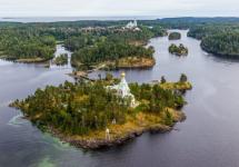
Rogalek lake and Pozhva river


Savushkin Spoons and Lake Black
The evening was spent according to their interests: they did not climb out of the lake, thrashed about, dived, tried to tame a perfectly round huge log, and I watched this whole circus - I did not want to climb into the lake at all. Moreover, there are tadpoles and, for sure, flocks of leeches! Yeah ...
Another night in a stuffy and hot tent, early morning, packing up home. Return trip decided to change a little so as not to walk the same road twice. But the crossing still could not be avoided, this time through Pozhva. In the same way, Lech transported us to the other side, again we had to wait until the boat dries up to pack it into a huge Lehin backpack. And further along the muddy road we went towards the highway, where we hoped to get on the bus Solikamsk-Perm. We didn't have any clear confidence in the buses, we went at random. The exit point to the road was not remarkable, it was not even known where the nearest stopping point... So we decided to wait right here, sitting on our backpacks. The first bus, which Ilya tried to stop, passed by. The driver in a suit, tie and shirt shook his head sympathetically. I would like to believe that he meant the lack of seats, and not our unpresentable appearance. But the next one stopped. We threw our backpacks into the trunk, sat down and quickly dozed off, from which 3 hours of the road flew by quickly enough. And here we are in Perm, the exam again a day later!
DURNYATSKAYA KOTLOVINA, LANDSCAPE NATURE MONUMENT OF REGIONAL SIGNIFICANCE.
Formed: by the decision of Perm. DEC of 07.06.88, No. 139.
The security regime is established: by the decision of Perm. DEC of 07.06.88, No. 139.
Borders: North: by North. border of the 25th and 26th sections of the 9th quarter of the Dobryansky agro-forestry, further along the sowing border of the 17th quarter of the SFF and sowing. the border of the 20 and 22 sections of the 10th quarter of the Dobryansky agro-forestry. East: East the borders of 22 and 23 sections of the 10th quarter of the Dobryansky agro-forestry to the southeast. the boundaries of the 10th quarter. South: southeast. border of the 10th quarter of Dobryansky agro-forestry before its intersection with the river. Pozhva. Zap .: on the left bank of the river. Pozhva, further along the west. the boundaries of the 8th and 25th divisions of the 9th quarter of the Dobryansky argoleskhoz.
For the first time, the monument was described and proposed for protection by K.G. Butyrina (1965).
It is a classic karst flow depression with spring lakes. The relief is hilly and ridged with heights of up to 217 m. The territory is composed of Permian sediments overlain by thin eluvial loams. A number of streams and rivers flow through the protected area: Pozhva, Istok, Pashtiha, Melnichny, Elitovka. There are 11 unique karst lakes here. Deep, sewage, weakly overgrown near the shores of the lake in the central part of the depression - Beloe, Chernoe, Rogalek, Kamenka - spring, feed mainly on karst waters. The lakes have low temperatures in summer and almost never freeze in winter. Beloe and Rogalek are the deepest lakes in the Perm region and the Urals, and lakes. Rogalek, 61 m deep, is the deepest karst lake in Russia. East lakes parts of the depression - Bolshoye, Maloye, Savushkin Lozhok, Novy Proval and Bezymyannoe - are drainless. In the western part of the depression there are small, drainless, waterlogged fresh lakes (Sidorovskoe and others). Water runoff from the Durnyatskaya depression occurs in the form of two streams flowing from the lake. White and flowing into the river. I'll eat. Vegetation is typical for the region of southern taiga fir-spruce forests. The main forest type is secondary aspen-birch with linden grass forests. Small areas are occupied by fir-spruce forests with linden undergrowth. On the shores of numerous lakes, coastal water, marsh and water complexes of vegetation are developed. A number of plant species included in the Red Data Book of the Middle Urals (1996) have been identified here: pure white water lily, Hebrides and spotted fingerlings.
Lit .: Butyrina K.G. Amazing lakes // Calendar-directory of the Perm region for 1966. Perm: Perm. book publishing house, 1965. S. 82-83 .;
Butyrina K.G. Karst lakes in the central part of the Perm region // Uchen. app. / Perm. un-t. 1973. No. 281. S. 60-92 .;
Butyrina K. G. Karst lakes / K. G. Butyrina, K. A. Gorbunova // Natural monuments of the Perm region. Perm, 1983.S. 54-65 .;
Butyrina K.G., Yashchenko R.V. To the thermics of karst lakes // Uchen. app. / Perm. un-t. 1967. No. 165. S. 49-54 .;
Karst and caves of the Perm region / K. A. Gorbunova, V. N. Andreychuk, V. P. Kostarev, N. G. Maksimovich. Perm: Publishing house Perm. University, 1992.200 s.
S. P. Stenno, G. A. Voronov, N. G. Tsiberkin, I. A. Lavrov, V. P. Levkovsky, E. N. Sadovnikova
Fishing in the Perm Territory pleases fishermen with an abundance of such representatives of lakes as pike perch, bream, pike, perch, ide, roach, burbot, gudgeon, ruff. Lake Beloe attracts fishermen in early autumn and spring thanks to its good perch, although getting to this lake is quite problematic. In the Cherdyn region, in a swampy area, there is a whole placer of large and small lakes, among which the largest is Bolshoy Kumikush. Pike, perch, ruff spawn in the lake, but due to the inaccessibility of the lake, fishing here in summer is almost impossible. But in winter it is easy to drive up to the lakes by snowmobile.
The lakes of the region are of karst origin. They are deep enough. The deepest lake is Rogalek. Its depth is 61 m. There are also underground lakes in the region (for example, in the Mountain of Friendship of Nations). Most of the lakes are inaccessible, with muddy bottoms. They are surrounded by forests and swamps. Getting to the lakes is very difficult, sometimes you need to use a helicopter.
There are many well-known lakes in the region: Berezovskoe, Chusovskoe, Bolshoi Kumikush, Beloe, Novozhilovo, Vostochny Maly Kumikush, Chelvinskoe and others. The following fish are found in the lakes of the region: ide, bream, pike perch, pike, burbot, ruff, roach, gudgeon, perch, pike.
Cherdyn district is famous for the most big lake... This is Lake Chusovskoe (length - 18 km and width - 3.5 km). .jpg)
Lake area: 1910 hectares. The average depth of Chusovsky is 2 m. Maximum depth lakes: 8 m. The bottom of the Chusovsky lake: silty. Here you can find: perch, tench, burbot, ruff, bream, ide, dace, roach, pike, gold and silver carp.
In the same area there is another famous lake - Berezovskoye. .jpg)
The bottom of the lake is muddy. Berezovskoye is rapidly growing. Its coast is swampy. Area 208 hectares. The maximum depth is 6 m. Roach, perch, pike, ide, bream, ruff, crucian are found in Lake Berezovsky.
Lake Kumikush Big has an area of \u200b\u200b178 hectares. .jpg)
The average depth is 3 m. The coast is swampy and overgrown with bushes. It contains perch, pike, ruff.
Fishing on Lake Bolshoy Kumikush: perch, pike, ruff.
How to get there:
In winter, the lake can be reached by snowmobile from the Kama River (the villages of Srednyaya Vortseva, Nizhnyaya Vortseva, Palniki). Until recently, there was a gully (temporary houses for living) on \u200b\u200bthe shore of the lake.
Average depth: 3.2-3.5m
Maximum depth: 6m
Outflowing rivers: in the southeastern part of the lake, a channel flows into Lake Chelvinskoye.
Height above sea level: 130.7m
Area: 17.8 km2
Wild rest: in tents.
Fee: Free
Bottom: peat and plant debris.
Fish: Lake Bolshoy Kumikush is home to perch, pike and ruff. The fish spawn in the southwestern part of the lake.
Geographic coordinates: Latitude: 60 ° 20′31.19 ″ N (60.341998), Longitude: 55 ° 16′16.15 ″ E (55.271154).
Settlements on the shore: the closest villages are Srednyaya Vortseva, Nizhnyaya Vortseva, Palniki.
Features:
Bolshoi Kumikush is the second largest lake in the Perm Territory, located between the Kama and Timshor rivers, located in the center of the Wild Swamp in the western part of the Cherdyn region. Several capes protrude into Lake Bolshoy Kumikush. The bottom is flat, the banks are swampy. Fir-trees, bushes, and many berries grow along the banks.
Lake Adovo is located in the Gain District. .jpg)
Adovo area: 360 hectares. The lake is 2 km wide and 3 km long. The depth of the lake: 5-6 m. In Adovo you can find: perch, pike.
Due to some geological processes (others argue that the lake has two bottoms), more often in the spring, the water begins to make a lot of noise, boil, and rise with a dome.
From above, the lake looks like an egg. The area is about 4 square kilometers, the depth is 5 - 6 meters.
As the doctor of philological sciences, professor of PSPU Ivan Podyukov says, this is perhaps one of the most mythologized objects Perm region... The legends associated with the lake and their variations are like stars in the sky on a cloudless night. So, one of them says that when the famous hero of the Permian Komi epic, Pera the Bogatyr, fought with a water vakul, he allegedly threw him into this lake out of anger. And since mythological heroes do not die, the wakul periodically reminds of himself, doing dirty tricks to people. One old woman told the professor that there was a pike in the lake - "nosh-sh-shadno big!" He waves his tail, as he says, and overturns the boat with the men. Why the pike is understandable.
Among the Finno-Ugric peoples, she was considered the totemic ancestor. In ancient times, it was not even eaten, it was considered a great sin.
And here is another legend: when the god flew across the sky with a sack, where he had collected evil spirits, the sack seemed to be torn over Hell's Lake, and all the devils fell out, now the lake is boiling and teeming with them.
Who sees the devils, who see Loch Ness monsters, and others see this bad place lake beauty mermaid. It turns out that what her mother gave birth to on a green island, lures fishermen and tourists. And, as it should be in all such stories about insidious women, after meeting with her, no one remains alive.
According to other legends, even earlier, when the lands were baptized, all pagans who did not want to accept Christianity were drowned in the waters of this lake.
There are stories that numerous robbers, robbing merchant ships in the upper reaches of the Kama, threw barrels of stolen gold for safekeeping in Lake Adovo. Later, during the division, they killed each other, and any place where many people died is considered bad, disastrous. “One hunter - a young hunter - said that it was very scary place... They say that even dogs that are acutely aware of demonic places refuse to go there, ”says Ivan Alekseevich Podyukov.
One of the modern scary stories Lake Hell: The locals allegedly saw planes dumping green containers with radioactive waste into the lake.
Who knows, the professor wonders, maybe the Gains just want to scare away the crowds of curious tourists who are ready to go to hell on the streets? Well, so that they don't bother them.
How to get there?
The lake is located 500 kilometers from Perm. You need to go from Perm through Kudymkar to the village of Gainy, further north towards the village of Seiva, from there along the old narrow-gauge road to Lake Adovoy. The road is difficult - through destroyed bridges and swamps. You can get there by URAL or KamAZ. In winter, it is easier to get to the lake by snowmobiles.
Lake Wild .jpg)
Perch and pike can also be caught on Lake Dikom (112 ha). Its average depth is 4 m. The lake is very swampy and overgrown with bushes.
Lake White .jpg) Lake Beloe is located near the Kama reservoir. Its coast is swampy and overgrown with bushes. Perch is found. White Square 32 hectares.
Lake Beloe is located near the Kama reservoir. Its coast is swampy and overgrown with bushes. Perch is found. White Square 32 hectares.
In Kungurskaya ice cave there was a place for 70 lakes different sizes, the water in which is surprisingly clean. .jpg)
BLUE LAKE
The lake is wayward and changeable, like a chameleon: today it is bluish black, tomorrow it is blue like a sapphire, the day after tomorrow it is emerald green. Fantastic beauty! And when you get into the water, your teeth beat like a tap and the skin breaks with goose bumps.
Cold water - 5 - 7 degrees. In winter, the lake does not freeze.
Blue is unique. This is not just a lake, but a vokluz - it is formed from an underground river, which beats with a powerful stream and breaks out to the surface. The deepest underwater cave of the Perm region is located here.
The shores of the lake are clayey, the volumes depend on the amount of groundwater. More water means the lake is dark, less water is blue.
The area of \u200b\u200bthe lake is from 200 to 300 square meters, the length is from 22 to 24 meters, the width is from 10 to 18 meters, the depth of the funnel of the lake is from 1.3 to 9 meters.
From it flows the Bolshaya Glukhaya river, which flows into the Chusovaya river 125 meters from the lake.
How to get there?
130 kilometers from Perm. Usually Blue Lake visited by tourists, rafting down Chusovaya. It is located in front of the Great Deaf Stones on the right bank of the river.
From Chusovoy to the lake a little more than 10 kilometers, but good roads no, you can get there only by water in summer, in winter - by snowmobiles, but this is a plus: the lake is of primeval purity.
ALEXANDROVSKY (LYTVENSKY) POND
Fishing on the Aleksandrovsky pond: perch, pike, bream, ide, burbot, ruff, chebak, bleak, minnow, tench, verkhovka, carp, dace, loach. Crayfish are found.
Direction from Yekaterinburg: Perm
Distance from Yekaterinburg (in the range): over 300 km
How to get there:
Distance from Yekaterinburg - 520 km.
We drive from Yekaterinburg in the direction of Perm, in Kungur we turn in a north direction and drive past Lysva through the cities of Chusovoy, Gremyachinsk, Gubakha, Kizel to the city of Aleksandrovsk.
Distance from Perm - 250 km.
From Perm you can go along the same road, through the town of Chusovoy, or you can go along the Solikamsk tract through Polazna, Berezniki and the village of Yayva.
Average depth: 4.5 m in the northern part, 6.5 m in the middle
Maximum depth: 8.5m
Sources of water supply: Lytva river, Bolshaya Rassokha river, Ursa river.
Outflowing rivers: the Lytva river.
Elevation: 175m
Area: 1.6km2
Fee: Free
The origin of the reservoir: Artificially formed on the Lytva River in 1805.
Bottom: gray and black silt, gray clay in places.
Fish: Perch, pike, bream, ide, burbot, ruff, chebak, bleak, minnow, tench, verhovka, carp, dace and loach are found in the Alexander pond. The water in the pond is quite cool, so stocking with carp did not bring the expected result. Crayfish are found in flowing places and in river mouths.
Geographic coordinates: Latitude: 59 ° 10'27.45 ″ N (59.174292), Longitude: 57 ° 34′1.19 ″ E (57.566998).
Settlements on the shore: Aleksandrovsk.
Features:
Alexandrovsky Pond is located within the city of Alexandrovsk in the Perm Territory. This is one of the oldest ponds in the Urals. The pond dam is located in the city of Alesandrovsk, the banks are high, steep with pebble ledges. The left bank in the upper reaches of the pond is low.
Votkinsk reservoir
Fishing on the Votkinsk reservoir: pike, perch, roach, pike perch, catfish, bream, burbot, sabrefish, bleak, silver bream, ide, crucian carp, rudd, sterlet, tulka, etc. (about 35 species of fish)
Direction from Yekaterinburg: Perm
Distance from Yekaterinburg (in the range): over 300 km
How to get there:
Distance from Yekaterinburg - 580 km.
From Yekaterinburg we follow to Perm, then we move south-west in the direction of Krasnokamsk. On the right bank from Krasnokamsk by car you can get to Nytva, Okhansk, Kazanka, Belyaevka, etc. settlements, standing on the banks of the reservoir and, in fact, choose a place for parking and subsequent fishing.
Average depth: 8-10m
Maximum depth: 29m
Outflowing rivers: Kama and its tributaries Bolshaya Lasva, Ocher, Siva, Bolshaya Nytva, Saygatka, Tulva (more than 50 tributaries)
Area: 1120km2
Wildlife: in a tent and in a car
Fee: Free
Origin of the reservoir: artificial (1964)
Geographic coordinates: 57 ° 10 ′ N 55 ° 00 ′ E
Settlements on the shore: Okhansk, Nytva, Kryukovo, Elovo, Kazanka, Belyaevka, Osa; cities on the reservoir: Krasnokamsk, Votkinsk, Tchaikovsky.
Features:
Votkinsk reservoir, created in 1964 in the vicinity of the village. Saigatka (now Chaikovsky) to regulate the flow of the Kama Votkinskaya HPP, today is a key supplier of water and electricity to cities and enterprises in the southwestern regions of the Perm Territory, is used for shipping and fishing.
Length coastline - 1000 km. The maximum length and width are 365 km and 10 km, respectively.
The reservoir of the channel type, with seasonal regulation of the drain, is conducive to the transit distribution of such fish to the reservoirs of the Kama basin as: catfish, tulka, goby, Nizhnekamsk sterlet.
For fishing for perch and roach, bays are ideal (Saygatsky, Tulvinsky, Ochersky, Nozhevskoy, Erzovsky); for pike and pike perch fishing, you can get out in shallow water (Vekoshinskoe, Chastinskoe, Kryukovskoe).
On winter fishing it is best to get out to river estuaries and bays.
LAKE WILD
Fishing on Lake Dikoe: perch, pike.
Direction from Yekaterinburg: Perm
Distance from Yekaterinburg (in the range): over 300 km
How to get there:
First, we get to Lake Teklyuevskoye: to Solikamsk by railway or motor transport, and then along an asphalt road about 90 km and another 15 km by forest. IN good weather any car passes. Then we walk along the shore of the lake along the path to the mouth of the Chernaya River.
Average depth: 4m
Height above sea level: 121.4 m
Area: 1.12 km2
Wild rest: in tents.
Fee: Free
Fish: The pond has a weak food base. Fishermen usually come here for large specimens of pike and perch, but there are fewer and fewer of them.
Geographic coordinates: Latitude: 60 ° 8′7.9 ″ N (60.135527), Longitude: 56 ° 30′33.68 ″ E (56.509355).
Settlements on the coast: Redikor village, Gorbunovo village, Rategova village.
Features:
Lake Dikoe has an oval shape, stretching from north to south. The coastline is heavily indented, the shores are swampy, by the end of summer the lake is usually heavily overgrown with above-water and underwater vegetation.
KAMSKOYE RESERVOIR .jpg) Fishing on the Kama reservoir: bleak, roach, chebak, perch, ruff, bream, pike perch, pike, burbot, asp, chehon, ide, blue bream, silver bream, tench, podust, rudd, sterlet, crucian carp, taimen, grayling, sprat.
Fishing on the Kama reservoir: bleak, roach, chebak, perch, ruff, bream, pike perch, pike, burbot, asp, chehon, ide, blue bream, silver bream, tench, podust, rudd, sterlet, crucian carp, taimen, grayling, sprat.
The ichthyofauna is formed by aboriginal fish of the Kama River and comprises 36 species. This is mainly bleak, roach (chebak) weighing up to 700 grams, perch up to 500 grams, ruff, bream up to 1.5 kg, pike perch reaching 8 kg, pike, burbot, asp up to 4 kg, saberfish, ide, blue bream and silver bream , sometimes tench, podust, rudd, sterlet and crucian carp are caught. There is a chance to catch a trophy pike in the bays of the upper part of the reservoir - Synvensky, Emelyanikha and others. In winter and spring, the fish is kept in the old channel of the Kama.
Popular fishing spots:
Obvinsky Bay (Obva River), especially near Ilyinsky, where the bay can be crossed over the bridge. In spring, up to several thousand fishermen come here. There are 34 fish species in the bay, the most numerous of which are perch, roach, bleak, bream, pike perch and ruff.
Inva Bay (Inva River). The right bank of the mouth of the bay is covered with spruce forests, high, the left is low with flooded peat bogs. There are Bazov Bor, Turyamor, Vishkinets islands and several floating islands that do not have a name. Perch, roach, bream and pike perch are kept in rafts and in the mouth of the bay. You can catch sabrefish on an elastic band. In summer, bream and roach are caught in warm water from the bottom, as the water becomes cooler - burbot.
Kosva Bay (Kosva River). A very popular fishing spot, despite the wastewater discharges from the enterprises of the Kizelovsky coal basin and Gubakha. On the first and the last ice perch, bream and roach are successfully caught in the bay. In summer, asp, pike and pike perch bite on the lure.
Chusovskaya Bay (Chusovaya River). Popular in terms of fishing for perch, roach and ruff, good bite bream, pike, pike perch, ide and sabrefish. Sometimes fishermen manage to catch taimen and grayling. In the section of the river from Krivoye to Ust-Shalashnaya in May, sterlet was caught, which was launched in 2003-2004. It should be remembered that taimen and sterlet are listed in the Red Book, and when caught, they must be released.
Sylva Bay (Sylva River). The bay is notable for the fact that ice melting and spawning occurs here several days earlier than in the rest of the Kama reservoir. Pike perch starts in February-March, it moves on the shallows to fattening in large flocks. The most successful zander is caught in the area of \u200b\u200bZhabreev, Trinity and Goryushek. In addition to pike perch, bream, perch, roach, ide, silver bream and sabrefish are caught in the bay.
Direction from Yekaterinburg: Perm
Distance from Yekaterinburg (in the range): over 300 km
How to get there:
Obvinsky Bay. We drive from Yekaterinburg to Perm, then through the Gaiva microdistrict along the Ilyinsky tract 94 km to Ilyinsky. In winter from central market in the city of Perm there is a special bus to the Gulf, departing early on Saturday morning.
Invensky Bay. We drive from Yekaterinburg to Perm, then either along the Inva River (the last 26 km are navigable), or along the road through Kudymkar, Yusva and Maykor. In winter, you can get to Maykor from Bereznyaki via Turlava and Pozhva.
Kosva Bay. We go to the Solikamsk tract, turn left from it to the mouth of the Chelva river or near the village of Nikulino to the villages of Krasnoe - Sobolki - Bor. You can also drive from Dobryanka past Bor Lenva, through the village of Visim to the villages of Nizhniy Lukh and Sobolki (they are located in the southern part of the bay), the path is about 70 km.
Chusovskaya Bay. We go to the town of Polazna, and from it along the road to the town of Chusovoy along a good highway. This road runs along the right bank of the bay.
Sylvensky Bay. We go from Yekaterinburg to Perm, then:
- through the microdistrict Yuzhny and Goly Mys to the village of Zhabrei (distance 26 km);
- through the Zaprud microdistrict along the Lyadovsky tract to the village of Troitsa along an asphalt road (36 km);
- through the Lobanovo village to the Mostovaya village along an asphalt and dirt road (39 km).
There is also an option to get along the Sylva River, it is navigable to the village of Kindelino.
Average depth: 6.4m
Maximum depth: 30, at the western bank of the river in the area of \u200b\u200bthe old channel in the dam reach, m
Drainage area: 168000 km2
Outflowing rivers: the Kama river.
Area: 1810 km2
Wildlife: in tents and a car.
Cultural rest: in any locality.
Fee: Free
The origin of the reservoir: Artificially created in 1953 during the construction of the Kamskaya TPP for energy purposes.
Comment:
The reservoir gets polluted waste water from industrial enterprises of the city of Solikamsk, Berezniki and others.
Flowing rivers and other sources of water supply:
the Kama river, the Chernaya river (3.3 km), the Tolych river (3.6 km), the Kemal river (4.3 km), the Polazninsky Vozh (Vozh) river (5.4 km), the Vasilyevka river (7 km), Upper Lukh river (8.7 km), Bykovka river (Bolshaya Bykovka, Myzya) (11 km), Osinovka river (Bolshaya Osinovka) (12 km), Polovinka river (15 km), Bolshaya Voronovka river (17 km), river The pier (17 km), the Bystraya river (Bolshaya Bystraya) (19 km), the Sylva river (21 km), the Kutamysh river (22 km), the Chelva river (22 km), the Maslyanka (Maslyana) river (23 km), the Cholva river (23 km), Yurman River (Upper Yurman) (23 km), Polutornaya River (27 km), Solomenka River (Brodovaya) (27 km), Bolshoi Ket River (Ket) (29 km), Bykovka River (30 km) , Tikhonovka River (33 km), Yeghva River (38 km), Nasadka River (52 km), Vetlyana River (57 km), Mutnaya River (60 km), Syra River (Malaya Syra) (60 km), Talaya River ( 60 km), the Shalashnya river (60 km), the Khmelikha river (74 km), the Serga river (84 km), the Komarikha river (90 km), the Usolka (Morokovka) river (99 km), the Kamenka river (112 km), the river Mechka (122 km), the Chermoz river (792 km), the Lower Lukh river (Lu x) (799 km), the Pozhva River (South Pozhva) (835 km), the Kondas River (872 km).
Geographic coordinates: Latitude: 58 ° 52′31.83 ″ N (58.875509), Longitude: 56 ° 17′40.66 ″ E (56.294628).
Settlements on the shore: Berezniki, Dobryanka, Chermoz.
Features:
The Kama reservoir was created on the Kama River, the length of the coastline is 1400 km. Seasonal fluctuations in water level up to 7.5 meters are characteristic, especially in February - April, at this time the volume of water decreases by almost 4 times, and the area of \u200b\u200bthe mirror decreases to 650 sq. Km. There are many bays in the Kama reservoir, named after the tributaries of the Kama river - Obvinsky, Invensky, Kosvinsky, Chusovskaya, Sylvensky and others. The width of the bays is up to 10-15 km, the length is 50-150 km.
LAKE NACHTY .jpg)
Fishing on Lake Nakhta: ide, pike, perch, chebak, bream, ruff, chub, asp.
Direction from Yekaterinburg: Perm
Distance from Yekaterinburg (in the range): over 300 km
How to get there:
Distance from Yekaterinburg - 760 km.
We go to the regional center of Gaina, then along the road along the right bank of the Kama to the village of Kasimovka. Here we take a ferry across the Kama River and take it to the village of Verkhnyaya Staritsa. The ferry can accommodate 3 cars, the price in 2011 is 250 rubles per car. Then we drive along the left bank of the Kama to the floodplain lake Nizhnaya Staritsa. At its mouth, on the high left bank, 3 roads start to Lake Nakhta, all are equally impassable. The roads go through the village of Nizhnyaya Staritsa, abandoned in 1960, and then through the marshes in a northeastern direction along the old leg road and are marked with landmarks. The depth in the swamp reaches 1 meter. Only high off-road vehicles (GAZ-66, "Ural") will be able to drive on the roads. It is much easier to move along the left bank of Lake Nakhta, until the middle of the lake the road goes along pine forest. Locals ride bicycles or motorcycles to the lake without wheelchairs.
Maximum depth: 3.5m
Sources of water supply: the lake is replenished with water from the nearby marshes, and during floods it connects to the Timsher River.
Outflowing rivers: Bartom River.
Height above sea level: 130m
Area: 2.28 km2
Wild rest: in tents.
Fee: Free
Bottom: peat.
Fish: Pike, perch, chebak and ide are abundant on the lake, sometimes chub, asp, bream and ruff are caught. The fish has a dark color due to the color of the water, the perch has bright red fins.
Duke), the ice was almost snowless. In the same - the snow was already too much for bicycles, and we went skiing.
Route.
Kobona - Zelenetsky Islands - st. Ladoga lake.
For a long time they tried and judged how best to throw themselves. If on a bike, then everything is clear: to Voybokalo by train, and then screw it in. With skis, such a trick does not work, you need to somehow get to the shore from the station. They even wanted to take a car from St. Petersburg, with Aks at the wheel (so that he drove the car back and did not have to come for it again), but decided not to complicate things, relying on the Voybokalo - Kobona bus (runs twice a day, here is his schedule).
4 people decided to take part: Sergey Radolitsky (serzh_r), Sergey Kislinsky (Pupsen), Sergey Rogachev ( [email protected]) and me, Dmitry Bulavinov (Bulawka). There were more, but many were confused by the two-day format, and some simply could not. We haven’t left the station yet, and Radolitskiy has already run over me why I’m getting out of the team - all Sergei, but I’m not, all with backpacks, and I with a drag, etc. :-) (And I really decided to test driving along Ladoga with a drag, because everything does not fit into a small backpack, and a large one is too big.)
About 16 went to Voybokalo; Several locals were hanging out near the station, they said that there would be a bus, but they also did not deny the option of its absence. And then they all (or almost all) disappeared somewhere. But around 16.20 a PAZik really arrived and took us to Kobona (55 rubles from the nose and 55 for luggage from everyone).
We unloaded at the intersection in Kobon [ ], and the bus went to Lavrovo (he makes a circle in one direction in the morning, in the other in the evening). And we went straight to the store [ ] for food (the store is expensive!), and Pupsen visited a department store next to him (he forgot absolutely everything - a bowl, a spoon, and a flashlight).
[Note. Here and below, the [ ] indicates the coordinates of the place in question, in the "WGS 84" coordinate system in the format fractions of degrees... Move the mouse to the icon, and the coordinates of the place will be highlighted as the alt-text. The points were picked from the GPS data of this trip, and further refined using digital photographs. And yet, mistakes should not be completely ruled out. There are definitely no errors in the GPS data from the hike, the link to which is given at the end of this story.]
We went to Ladoga through the canal. It is getting dark. Cars of fishermen return to land in a long line, creating a picture very similar to the photographs from the Road of Life of the war ... Zelentsy is visible in the distance, about 10 km away. The weather is normal, the wind is not strong. There are no cracks, no hummocks, little snow, in short, beauty.
When we came to the island of Bolshoy Zelenets, it was already completely dark. We got up at the same place as a year ago [ ]. The firewood is so-so, the water was taken from the lake (ice is 40 centimeters). Phoned friends who spend the night in Kobona in a pretentious hotel, and are going to jerk off along the Road of Life on fat bikes tomorrow morning (the same as the usual big one, only tires 3 "and thicker). We drank, had a snack, had a snack and went to bed. covered about 11 km.
Pupsen took a summer sleeping bag with him (and, just in case, slept in a down jacket and boots and therefore froze), woke up first and cooked porridge (although usually Radolitsky is blown up first).
 |
We left at about 11. As we rounded the island, the muzzle began; albeit from the side, but strong, albeit without gusts. There is little snow on the ice; in some places there is barely sprinkled ice, but generally unsuitable for skates. We crossed a couple of cracks, problem-free, surrounded by small hummocks. It would be easy to drive the Road of Life by car under the given weather conditions.
We saw a couple of kiters, one of whom was probably Vitya Schultz, moving towards the fat biker team. Fatbikers called me all the time: just put on a mitten and warm your hand, the next one calls. Like, where are you? Let's go ahead, damn it. :-)
 |
 |
 |
 |
Closer to the shore, Radolitsky and Pupsen rushed to the lighthouse in Osinovets and, after some fig, went ashore right there, and they had to stomp a couple of kilometers on foot. And Rogalik and I walked along the lake, joining the ski column returning from the start of the annual bike ride along the Road of Life (along its coastal part, from the “Broken Ring” monument on the Ladoga bank to the “Flower of Life” monument on Rzhevka), and went ashore [ ] very close to the station "Lake Ladoga" [ ], literally 300 meters from it.
Available in the Perm Territory unique territory, known as the Durnyatskaya depression. This specially protected natural area of \u200b\u200bregional significance is better known to specialists as a karst depression.
The Durniat depression is a rare natural monument: a castro field with 11 lakes. Among them, the deepest (61 m) castro lake in Russia is Rogalek. Many springs have a salty taste due to their strong mineralization. Located 120 km from the city of Perm. Lake Rogolek is considered the deepest karst lake in the Urals, while its dimensions are only 57 by 105 meters. In a few publications indicating that its depth reaches 61 meters, it is mistakenly called the deepest karst lake in Russia. Apparently, no one knows for sure, since the last systematic work on the study of the karst of the basin was carried out in the 60s. Since then, none of the scientists have seriously dealt with depression. But still, Rogolek Lake can be called unique, claiming that it is the second deepest in Russia (after Lake Tserik-Kel in Kabardino-Balkaria). In winter, an ice hole remains above its deep part, Lake Kamenka is not covered with ice, and Lake Beloe is covered only in severe frosts. The reasons lie in the abundant outlets of saline groundwater with a constant temperature.
In addition to the depth, the lakes have another remarkable quality; their water is salty, as in the sea there is the periphery of the Verkhnekamskoye potassium-magnesium salt deposit. There is a discharge of groundwater, which, dissolving salt-bearing rocks, go to the surface of the earth. This is how deep salt lakes appear.
Pozhva river  Beaver Dam on Melchikhinsky Creek
 If you go up the Melchikhinsky stream you will get here. This is Rogolek.
  Lake Black
 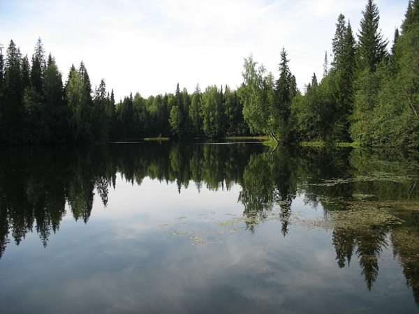 Lake Big
  On the outskirts of the Durnyatskaya depression
  Lake Maloe