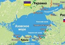
Kalamitsky Bay is a part of the Black Sea, jutting into the western coast of the Crimean Peninsula between Capes Lucullus and Evpatoria. This bay is partially washed by the coast of Sevastopol in a small area from Cape Lukull to the administrative border with the Bakhchisarai district (only 1.5 km approximately). The entire area around Cape Lucullus is protected by the state as a nature reserve and is an object of a unique natural fund. The coastal aquatic complex occupies more than 125 hectares; it is a hydrological natural monument.
Kalamitsky Gulf. Geography
Kalamitsky Bay is a picturesque place. The width of the bay at the entrance is 41 km, 13 km from the entrance to the coast. The depth reaches 30 meters. The bay in the north rests on the city of Evpatoria. The shores in the south of the bay are clayey and high, in the north are sandy and low, where in many places there are beaches. Salt lakes are found not far from the coast, behind sandy barrows. The largest of them:
- Saki,
- Sasyk,
- Gull,
- and healing lake Kyzyl-Yar.
Several rivers flow into the Kalamitsky Gulf (Belbek, Alma, Bulganak and Kacha). Directly on the shore of the bay there are several settlements visited by tourists, including Beregovoe, Uglovoe, Novofedorovka, Andreevka, Nikolaevka, etc.
There are different versions regarding the name of the bay. The most common one associates the name with the city of Calamita, which was built by the Genoese. The city has not survived to this day. Translated from Greek, Kalamita is translated as "good cape".
Attractions and places of rest
Not far from Cape Lukull is the Ust-Alminskoye settlement. This is a Scythian settlement that arose at the turn of the 2nd century BC. Its true name is not known. In fact, many ancient settlements existed in this part of Crimea, but not all have survived. For example, due to the collapse of the soil into the sea, more than half of the Ust-Alminskoye settlement were irretrievably lost. 

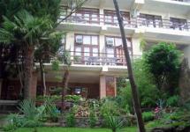
There are many private hotels and boarding houses along the coast of the bay. Tourists wishing to come here will find a place to stop.
Some of them, for example, the recreation center "Volna" (information on) are located near the sea, but also not far from lakes or estuaries.
The city of Evpatoria is considered a children's health resort precisely because of the favorable climate and shallow water of the Kalamitsky Gulf. The beaches are mostly sandy. The Kalamitsky Gulf warms up very quickly and often the swimming season begins in May and ends in September. 

Compilers
P. A. Tilba, R. A. Mnatsekanov, V. A. Krutolapov.Geographical coordinates
45 ° 17'34 '' N, 36 ° 45'46 '' EHeight
0-5 m above sea level.Area
38 400 hectares, including the water surface: 38 400 hectares.a brief description of
Shallow sea bays, the shores of which are covered with steppe or wetland vegetation.Wetland type
A, E, G, J; prevailing: J, A.Ramsar criteria
4, 5.Criterion 4: The area is one of the wintering centers for waterfowl, the importance of which increases in cold winters when the water area of \u200b\u200bthe estuaries of the Eastern Azov Sea freezes.
Criterion 5: Up to 1 million birds stop here during migrations (Wetlands of Russia, 2000). During the mid-winter surveys carried out from the shore using telescopes, we counted about 20,000 in 2003, in 2004 - about 10,000, in 2005 - up to 8,000, in 2006 - about 49 500 pcs. waterfowl and near-water birds.
Location
Taman Peninsula, southwestern part of Krasnodar Territory, 30 km from Temryuk.Physical and geographical characteristics
The area is a low-lying relief, which was formed as a result of slow tectonic subsidence of the land, occurring at a rate of 2-5 mm per year (Kanonnikov, 1984). The surface of the coastal land is composed of deltaic and alluvial sediments, under which the marine sediments of the Neogene and Paleogene lie. The bays are permanent bodies of water of natural origin. The salinity of the water in them reaches 11.3 ‰, decreasing near the coast to 2-3 ‰. The depth of the bays varies within 0.5-2.5 m. Typical formations of the Taman and Dinskoy bays are lagoons - salt lakes Markitanskoye, Tuzla, etc. In the water area of \u200b\u200bthe bays there are shell-sand islands and spits of various configurations. The mud volcano Blevako is located on the coast of the Chushka Spit in the water area of \u200b\u200bthe Taman Bay.The shores of reservoirs are composed of unstable rocks and are subject to strong destructive activities of the sea. The soil cover is mainly composed of southern chernozems with a low humus content. The type of climate of the area of \u200b\u200bthe site belongs to the coastal steppe, moderate continental. The average January temperature is -0.8 °; July 23.6 ° С, precipitation during the year is 330-340 mm.
The significance of the site in the natural water cycle
The catchment basin of the site is a hilly plain formed by marine sediments. Uplands (reaching a maximum height of 164 m above sea level) are active or extinct mud volcanoes. The soil cover is represented mainly by chernozems, including their solonetzic and saline varieties; there are powerful chestnut soils. The main types of land use: field cultivation, vegetable growing, viticulture, animal husbandry. The climate is moderately continental.Environmental parameters
On the shores of the bays, there are communities of psammophilic and hydrophilic vegetation. Coastal shallow waters, shell spits, islands are extremely important for the existence of waterfowl.Valuable flora
One of the most widespread plant communities on the site is psammophilic vegetation. Floristically, this is the best preserved natural ecosystem both in the coastal part of the Taman and Dinskoy bays, and in Taman as a whole. Characterized by coastal sands sandy spikelet, common sea mustard, finger pork, pontic katran, naked licorice, toadflax and others. Of the halophytes on the coastal sand-shell dunes, white sweet clover, tangled and creeping Sveda, soda ash and tragus, Meyer's kermek, etc. are widespread.And on wet salt marshes - bluegrass-wheatgrass, sage-sedge and saltwort associations. The vegetation of reservoirs is formed from plant species immersed in water: hygrophytes, hydrophytes and hydatophytes. Phytocenoses are widespread in the seaweed and scotchweed, often forming pure groupings over large areas. An equally common species is holly pond. Two types of uruti grow in water bodies of the land: urut spikelet and whorled. In some coastal areas, typical flooded vegetation is found with the presence of common reed, cattails, sedges (Tilba and Nagalevsky, 1996).
Valuable fauna
Role of the area as a nesting place for birds. The area has a certain value as a place of reproduction of near-water bird species listed in the Red Data Books Russian Federation and Krasnodar Territory: Shelf, oystercatcher (subspecies Haematopus ostralegus longipes), sea plover, little tern. On the territory of the islands there are colonies of the great cormorant with a total number of 750 pairs, the river tern - 300 pairs, and the spotted tern - 300 pairs.The role of the region as a place for bird migration. The area is located on an intensive migratory route for birds running along the coasts of the Azov and Black Seas. Autumn concentrations of gull, black-headed gull, and bank heron were noted within Temryuk and Dinsky bays (Vinokurov, 1965). In the fall of 1995, 200 thousand wasps were recorded here. coots, 54 thousand - mallards, 200 thousand - red-headed duck, 1.5 thousand - mute swan (Vinogradov, 2000). The area is a place of stops and large concentrations of migratory waders: turukhtan, turners, herbalists, etc.
The role of the region as a wintering place for birds. The site is a traditional wintering ground, primarily for waterfowl. In the period from 1967 to 1972. there were from 6 thousand to 250 thousand wasps. IN recent times within the territory there are up to 48.5 thousand waterfowl
(2006 data).
Swans. Mute swans and whooper swans are found during the winter. Last view prevails in numbers in colder winters (in 2003, 1,500 were recorded).
Ducks. The most numerous wintering species is the crested duck (according to 2003 data - 11,500 individuals). In warmer winters, the number of crested ducks is much lower. Of the other species of ducks, the most common are the mallard, the red-headed duck.
Other types of waterfowl. The most characteristic species are the great grebe, great cormorant, coot, and gull.
Kuliki. On the territory of the site in winter, the following were recorded: herbalist, great snail, medium curlew, great curlew, snipe, black-throated dunlin; on the adjacent territory of the Kerch Strait coast of the Chushka spit, the oystercatcher was recorded during the winter (Mnatsekanov et al., 2004b; Dinkevich et al., 2005).
Role of the area as a habitat for rare and vulnerable bird species.
Black-throated loon. A common species during the period of migration, in small numbers it is found in winter.
White-tailed eagle. Regularly wintering species.
Demoiselle crane. Nesting species of adjacent territories.
Bustard. Nesting species of adjacent territories.
Bustard. Featured in winter time in the coastal part of the site.
Oystercatcher. Common breeding species; rare, irregular wintering species.
Great curlew. Not abundant, regularly encountered in winter.
Black-headed Gull. Occasionally celebrated in winter.
Role of the area as a habitat for marine mammals. Tamansky and partly Dinskaya bays are home to the Black Sea bottlenose dolphin, a subspecies listed in the Red Data Books of the Russian Federation and Krasnodar Territory.
Social and cultural significance of the site
Within the boundaries of the site are located the most valuable historical and archaeological monuments associated with the Tmutarakan principality of the XI-XII centuries. In addition, there is a house-museum of M. Yu. Lermontov on the territory of the site.Forms of land ownership
State.Land use
Fishing is the main activity on the site; in the surrounding area - winemaking.Factors negatively affecting the condition of the site
Expansion of the area for the construction of Port Kavkaz.Environmental measures taken
Part of the site is part of the Zaporozhye-Taman Zoological Reserve. By the order of the Government of the Russian Federation of 12.04.1996, No. 591-r, the reserve (the name “Tamano-Zaporizhzhya reserve” is given in the order) is classified as a specially protected natural area of \u200b\u200bfederal subordination. According to the Regulations of the reserve, its area is 30,000 hectares.Proposed environmental measures
Solving the issue of the status of the reserve. Correction of the Regulations on the reserve, taking into account the importance of the territory as a place of mass wintering of semi-aquatic birds, including rare speciesas well as nesting places for rare bird species. Giving the status of a Ramsar site to the entire water area of \u200b\u200bthe Taman and Dinskoy bays.Scientific research
Scientific research within the site was and is being carried out in the course of studying the biota of the Taman Peninsula as a whole. Besides, in last years special mid-winter counts of waterfowl are carried out here as part of the Wetlands International project on the Central Asian flyway, funded by the Ministry of Agriculture, Nature and Food of the Netherlands.Environmental education
Currently not available. There are good opportunities for organizing observations of migratory and wintering birds.Recreation and tourism
The site is intensively used for tourist purposes, mainly in the historical and cultural sense. Recreational loads on the habitats of plants and animals are low.Jurisdiction
Administration of the Temryuk district of the Krasnodar Territory.Site management authority
Tamano-Zaporozhye reserve is under the departmental subordination of the Office of the Federal Service for Veterinary and Phytosanitary Surveillance for Krasnodar Territory and the Republic of Adygea.Black Sea coastline
The Black Sea is located in the northern temperate belt of the Earth, stretching from north to south between points with coordinates 46 °, 32 ′ and 40 ° 55 ′ north latitude.
But if we bear in mind the climatic features, then the coastline of the Black Sea belongs to two zones. The northern and western coasts correspond to the temperate zone, and the southern coast of Crimea, the coasts of the Caucasus and Turkey, to the subtropical belt, and the southern part Black Sea coast The Caucasus and the Colchis Lowland are humid subtropics with an annual rainfall of 1400-2500 millimeters. One of distinctive features subtropics is a mild winter, allowing year-round vegetation of plants.
Length coastline The Black Sea is about 4790 kilometers long. This is not a constant, fixed value. Not only the length, but the whole appearance of the shores is constantly changing under the influence of both natural forces and at the will of man. Among natural factorsaffecting the seashore, the main role belongs to waves and currents. Inaccessible coastal cliffs, picturesque bays, islets, “velvet” flat beaches, covered with sand and silt of the harbor, washed-out road embankments, villages and resorts destroyed by landslides - all this is the result of the activity of the surf and currents.
So writes about the "life" of sea coasts in the annotation to his book "The Shores of the Black and Azov Seas", a prominent specialist in this field of marine science, Professor V.P. Zenkovich. Thanks to the works of V.P. Zenkovich, his colleagues and colleagues, the Black Sea coast is now the most studied. This made it possible to successfully carry out large-scale works on their strengthening and improvement in a number of places. Description of the Black Sea coast at V.P. Zenkovich is not only a valuable source of firsthand scientific information, but also a poetic story about that very specific zone where the sea meets land.
So, all the way from the Danube to Ochakov there are the famous "velvet sands", sandy strips of sea beaches, as well as numerous estuaries. Clay cliffs are not rare here. They are constantly breaking down sea \u200b\u200bsurf, and from time to time, landslides of a grand scale occur. Now landslide phenomena, thanks to the development of the science of the seashore, have been tamed by a system of powerful coastal protection structures.
From Ochakov to Western Crimea, the shores are also characterized by their sandy beaches and low cliffs. Between the Dnieper-Bug estuary and the Karkinitsky bay there are extensive sandy spits (Kinburnskaya, Tendrovskaya) and islands (Dolgiy, Krugly, Dzharylgach). These are mostly sparsely populated or completely uninhabited places, a kingdom of birds, all kinds of small animals, deer, and even wild horses on Tendra. Here is the Black Sea State Reserve of the Academy of Sciences of the Ukrainian SSR, where a lot of work is being done to study gulls and others, birds, their role in the life of the sea and land. Nearby are the large bays of the Black Sea: Yagorlytsky, Tendrovsky, Dzharylgachsky, Karkinitsky, which in their own natural features - shallow water, protection from waves, remoteness from settlements, from powerful sources of pollution, high biological productivity and others - are considered the most promising places for the development of underwater farms in the Black Sea.
The southern coast of Crimea is mountainous. Crimean mountains they are not particularly high, but their summit plateaus - yayls - lie very close to the sea and fall in sheer cliffs several hundred meters high. Sheltering the coasts from northern winds, they create here climatic conditions subtropics. Beaches South Shore Crimea is not sandy, but pebble and much narrower than the north-western coast of the Black Sea. The underwater landscape of the southern coast of Crimea is very beautiful: clear water, many rocks (some of them rise above the sea surface) and blocks overgrown with algae, mussels and other organisms. The species diversity of fauna and flora makes these places convenient for exploring the inhabitants of the sea, especially for scuba divers.
The southern coast of the Kerch Peninsula, as well as the southern coast of Taman, is distinguished by wide sandy beaches and shallowness of the coastal strip of the sea, somewhat reminiscent of the north-western coast. Salty seaside reservoirs are found here again. On the Kerch Peninsula there are Uzunlarskoye, Koyashskoye and Tobechikskoye lakes, on the Tamanskoye Peninsula - the Tsokur, Kiziltashsky, Bugazsky and Vityazevsky estuaries. And the water is more turbid than that of the southern coast of Crimea, and desalinated by the runoff of the Azov Sea through Kerch Strait... From Anapa to the southeast to Batumi, the Caucasian coast stretches with a predominance of pebble beaches. The coastal mountains are covered with dense forest, numerous evergreen trees and shrubs, citrus fruits. Great depths come close to the shore. Mountain rivers bring little turbidity, and the sea water is transparent, like the southern coast of Crimea.
Turkey's Black Sea coast is mountainous, with narrow, mostly pebbled beaches and rapidly increasing depths.
The shores of Romania and Bulgaria resemble the northwestern ones and are also famous for wide sandy beaches. As in the Odessa region, clay cliffs prevail here, there are salt lakes and estuaries, and the sea is desalinated by the Danube runoff.
Acquaintance with the wildlife of the Black Sea coast is greatly facilitated by visiting local local history museumsfound in all cities, as well as botanical gardens and marine aquariums.
Among the botanical attractions on the Black Sea coast, the botanical garden of Odessa State University, founded in 1867, the Nikitsky Botanical Garden in Crimea, created in 1812, the Arboretum in Sochi, founded at the end of the last century, the tisosamshitovy grove, located two kilometers from the sea, should be mentioned. the Khosta river, - the remains of the ancient relict flora, the subtropical park in Gagra, the Pitsunda relict long-coniferous pine reserve at Cape Pitsunda, the Sukhum Botanical Garden, and finally the Batumi Botanical Garden, founded in 1912, one of the largest and most famous in our country.
Marine aquariums are less ancient and famous than botanical gardens. They are very helpful in getting to know the inhabitants of the Black Sea, their appearance and habits. In our country marine aquariums created in Sevastopol at the Institute of Biology southern seas, in Kerch at the Azov-Black Sea Scientific Research Institute of Marine Fisheries and Oceanography, in Sochi in the Arboretum and in Batumi at the Georgian branch of the All-Union Institute of Marine Fisheries and Oceanography. The Black Sea fauna is most fully represented in the Sevastopol Aquarium, opened back in 1897 at the biological station and subsequently modernized several times. Today it is a very popular institution that showcases the inhabitants of the Black and other seas. There is a central round pool with a diameter of 9.2 and a depth of 1.5 meters, as well as 12 wall aquariums with a volume of up to 7 cubic meters. Several dozen species of Black Sea fish, crabs, molluscs and other animals can be observed in the aquarium at the same time.
The first scientific demonstration dolphinarium in our country was recently opened in Batumi, where there is an opportunity to get acquainted with the Black Sea dolphins and the work that scientists and trainers carry out with them.
There are several reserves on the Black Sea coast. The largest of them is the Black Sea State Reserve of the Academy of Sciences of the Ukrainian SSR with an area of \u200b\u200bmore than 60 thousand hectares, founded in 1927. It is located between the Dnieper-Bug estuary and the Karkinitsky bay on the sands of the Kinburn and Tendrovsky spits, the islands of Krugly, Dolgiy, Orlov, Babin and others. The area occupied by the reserve is 12 606 hectares. The rest of the area is shallow sea water.
The biggest attraction of the Black Sea reserve is a large colony of black-headed or Mediterranean gulls, numbering up to 200,000 pairs. This beautiful white bird with a brilliant black head (the so-called "mating outfit", in winter the gull's head is white), during the nesting period is found in many places - in Greece, Asia Minor, Romania, and even in Mongolia, but its largest colony is in the Black Sea reserve. The black-headed gull deserves protection not only as one of the adornments of the sea coast, where there are fewer and fewer deserted places near the sea, but also as a human assistant in the fight against agricultural pests. The fact is that, in addition to small fish and marine invertebrates, this gull feeds on insects that it hunts in the steppe. Scientists have calculated that over the summer, black-headed gulls from the Black Sea Reserve, together with their chicks, eat more than 5 thousand tons of insects, which prevents an annual loss of up to 2 million rubles to agriculture. An excellent example of a combination of nature conservation and a biological method of pest control that is safe for humans!
Another protected place on the Black Sea coast is located around Cape Kaliakra in Bulgaria. On the secluded coastal cliffs of this steep cape, the only species of seals in the Black Sea - the monk seal - breed. It is listed in the International Red Book of rare and endangered species. According to Bulgarian scientists, only a few pairs of seals remain there today, which are under strict state protection.
Yes, it is more and more difficult now for birds and animals to find secluded places on the shores of the Black Sea. People are so fond of them that sometimes it seems: a little more time will pass - and all coastal settlements will merge into a continuous ring of cities and resorts. In any case, there is talk about the resort development of the entire coastline back in this century. Of course, the sea should help people in rest and treatment, this is indisputable. But what are the reasonable limits of this "human load" per unit of coastline has not yet been calculated. This is one of the immediate and responsible tasks of science. In the meantime, the ranks of all kinds of recreation centers, camps, campgrounds, medical institutions, sports centers, beaches, boat docks and other forms of "sea use" are growing unhindered, why not introduce such a term, by analogy with "nature management"? Our relations with the sea must be built in such a way as to ensure a gentle regime for it. Indeed (in addition to these seasonal recreational and medical facilities) around the Black Sea there are about forty settlements of the rank of ports with a population of about 4 million people and with a certain negative impact on the marine environment. Thus, according to statistics, there is about 1 meter of coastline per one permanent inhabitant of the Black Sea coast. But in summer, the population at least doubles, and then the share of the coastline per person is reduced to half a meter. And if we take into account that “sea use” is not evenly distributed along the coast, then in settlements, resorts and other places the “personal” section of the coast is sometimes reduced to a few centimeters. This is the tense ecological situation, requiring from a person special thrift and attentiveness to the natural environment around him, for the sake of meeting with which he sometimes overcomes thousands of kilometers and bears so many bright plans during the year. And since the concept of "nature protection" implies, first of all, the protection of its living inhabitants, let's move on to getting to know them.
Yu.P. Zaitsev
Photo beautiful places Crimea


The Black Sea, connecting through the Bosphorus and Dardanelles straits, as well as the Marmara and Mediterranean seas with the Atlantic Ocean, is strategically important for Russia. The coastline was conquered by the state, some territories remain the subject of disputes today.
Russian Black Sea coast

(Black Sea coast with resort cities of Russia)
The length of the Russian coastline of the Black Sea today is 1200 km. It starts with Caucasus mountains, continues along the coastal strip from Taman to Adler, and includes the Crimean coast.
Its relief is represented by the mountains of the Caucasus and the South Coast of the Crimea, lowlands and estuaries, mainly in the eastern part, as well as steep ledges. In general, the line is poorly indented, there is only one peninsula - Crimea. There are no islands in the Black Sea.
Russia's exit to the Black Sea
For the first time, Russia began to claim access to the Black Sea with the appropriation of coastal lands in the 18th century. It was a victorious war with Turkey, which resulted in the conquest of Anapa and the Crimean Peninsula. After that, at the beginning of the 19th century, the settlement of the conquered lands by the Slavs began.
Crimea was given to Ukraine immediately after the collapse of the Soviet Union, but in 2014 the entire peninsula, including the Crimean Black Sea coast, became part of Russia again, and is the subject of disputes with Ukraine and the Western world.
Characteristics of the Black Sea

Depth: maximum 2210 m
Average water temperature (Black Sea coast, Russia): Winter 7.7 ° C, Summer 19 - 24 ° C
Coast: pebbles, gravel, sand and steep stone banks
Climate: mostly continental, the Black Sea coast of the Caucasus and Tuapse have a milder subtropical climate
The location of the coastline of the Russian Black Sea coast and the landscape features led to the formation of three climatic zones at once:
- humid subtropical;
- mediterranean;
- moderately marine.
The underwater world of the Black Sea is represented by dolphins and a species of shark - katrana. The latter are not dangerous for people. Among the commercial fish found in coastal waters, it is worth noting the flounder, goby and mullet.
Cities on the Black Sea in Russia

(Sandy sandy shores of Anapa)
Most of the cities on the Russian Black Sea coast have the status of resorts, due to the availability of appropriate resources and climatic conditions on the territory.
Anapa... The most western settlement among the cities of the mainland of the Russian Black Sea coast. At one time, the capture of the Anapa fortress allowed the Russian government to exercise control over the Black Sea. Today, it is a resort town.
Novorossiysk... The city does not have a resort status, despite the annual number of tourists. Locality surrounded on all sides by the mountains of the Caucasian ridge, but not high. The same relief is characteristic of the vicinity of Gelendzhik. The height of the mountains in the Gelendzhik region is greater.
Tuapse... It is the starting point of the Black Sea coast of the Caucasus. The resort is surrounded by high mountains.

Sochi... The largest and most equipped resort in the Russian Federation. Known all over the world. The length of the Greater Sochi coastline is over 100 km.
Kerch... The most east point Crimean coast. The city is located at the junction of the Black and Azov seas. In Kerch there is a ferry connecting the peninsula with the mainland of Russia.

(Stone coast of the Crimean peninsula)
Yalta... World famous resort city with a mild climate. Located surrounded by the high Crimean mountains.
Sevastopol... A city with federal status. The Black Sea Fleet of the Russian Navy is based in its bays. The city does not have the status of a resort, its infrastructure is designed to serve the base of the Russian Black Sea Fleet.
Evpatoria... Most big City from the western side of the Crimean coast. It is a health resort. There are many children's recreation centers and hospitals here. It is a recognized balneological resort.
In the north, through the Kerch Strait, it connects with the Azov Sea. A large area of \u200b\u200bland - the Crimean Peninsula - cuts deep into the sea surface. On the shores of the reservoir there are countries such as Russia, Georgia, Abkhazia (partially recognized state), Turkey, Bulgaria, Romania, Ukraine.
Geographic data
According to the US gazetteer, the Black Sea area is 436.4 thousand square meters. km (168.5 thousand sq. miles). Maximum depth is 2,212 meters (7,257 ft). The average depth corresponds to 1240 meters (4067 feet). The total volume of salt water is 547 thousand cubic meters. km. The greatest length from west to east is 1175 km. The maximum length from north to south is 580 km. The reservoir is notable for the fact that at a depth of more than 150 meters, all life is absent due to the saturation of deep waters with hydrogen sulfide.
The coastline is slightly indented. Its total length is 3.4 thousand km. There are large bays such as Sinopsky, Samsunsky, Feodosiyskiy, Varnenskiy, Tendrovskiy, Bourgas, Kalamitskiy, Yagorlytskiy. In the northern and northwestern regions, estuaries overflow at the confluence of rivers. There are many swampy and brackish areas. The western and north-western coasts are low-lying, in places there are cliffs.
In the south and east, the spurs of the Pontic and Caucasian mountains rise to the sea. In Crimea, the coast is low, only the southern part of the peninsula is remarkable for its mountainous shores. A similar relief is observed on the Tarkhankut Peninsula in the western part of Crimea.
Islands
There are few islands. The largest island is Dzharylgach with an area of \u200b\u200b62 sq. km. It is part of the Skadovsky district of the Kherson region. It is washed by two bays - Dzharylgachsky and Karkinitsky. Since 2009, a national natural park has been located on the island.
Other islands include Serpentine. It is part of the Odessa region, has a cruciform shape, and its area is 20.5 hectares. On this piece of land is the village of Beloe.
Other large island is called Berezan. It is located in the sea at a distance of 8 km from the city of Ochakov. Belongs to the Nikolaev region. It stretches for 1 km in length and 500 meters in width. The island is uninhabited and has the status of a historical and archaeological reserve at the Academy of Sciences of Ukraine.

Black Sea on the map
Rivers
Such large European rivers as the Danube, Dnieper and Dniester flow into a huge salt reservoir. In addition to them, Inguri, Mzymta, Rioni, Kodor flow into the sea from the east. They originate in the Greater Caucasus Mountain Range. Sakarya, Chorokh, Yeshilyrmak flow into the southern part of the reservoir. The Chorokh River flows into Georgia, and the other two into Turkey.
The Southern Bug carries its waters to the northern part of the reservoir. This river flows entirely through the territory of Ukraine. It has a length of 806 km. In the west, the sea is fed by the Bulgarian rivers Veleka and Kamchia.
The annual flow is approximately 310 cubic meters. km. At the same time, 80% of all water is provided by the Dnieper and Danube. It should be noted that the reservoir has a positive water balance. The net outflow of water is 300 cubic meters. km per year. Water flows through the Bosphorus into the Sea of \u200b\u200bMarmara and further into the Aegean and Mediterranean. At the same time, there is a bilateral hydrological exchange. Saltier and warmer water flows from the Mediterranean to the Black Sea.
Cities
There are many large cities on the seaside. The largest of these is Istanbul (Turkey) with a population of 13.6 million. In second place is Odessa (Ukraine) with a population of 1 million people. Ranked third turkish city Samsun with a population of 535.4 thousand people.
This is followed by the Bulgarian Varna. It is home to 474 thousand inhabitants. The fifth place belongs to the hero city of Sevastopol with a population of 379 thousand people. Then there are Sochi (Russia) - 343.3 thousand people, Trabzon (Turkey) - 305 thousand people, Constanta (Romania) - 284 thousand people, Novorossiysk (Russia) - 242 thousand people, Burgas (Bulgaria) - 224 thousand inhabitants.

On the Black Sea beach
Climate
The climate prevailing over the reservoir largely depends on the Atlantic Ocean. It is above it that those cyclones arise, which then bring rains and storms to the sea. Cold air masses come from the north. Warm winds blow from the southwest. All this variety forms hot and dry summer weather. As for the winter, it is warm and humid.
Winter temperatures range from minus 1 to plus 5 degrees Celsius. Very rarely, it drops to minus 10 degrees Celsius. Snow falls only in the northern regions. The average summer temperature is 24-25 degrees Celsius. At its maximum, it rises to 37 degrees Celsius. The warmest part of the coast is the Caucasus, where the average annual temperature is 17 degrees Celsius.
In the southern part of the Black Sea, the climate is milder than in the northern one. It is also less wet. Precipitation falls more evenly. They are possible not only in winter, but also in summer. Black Sea water does not freeze in winter. Only once every few decades in the northern regions, the water can be covered with ice in a too cold winter. The average water temperature is 7-8 degrees Celsius.
Ecology
In general, the ecological situation in the reservoir is unfavorable. Many polluted rivers flow into the sea, as well as runoff from the fields, saturated with nitrates and phosphates. This provokes the growth of phytoplankton. The transparency of the water decreases, and multicellular algae die. Waters are polluted with oil products, waste water, construction waste. Recently, the number of dolphins, tuna, mackerel has noticeably decreased. But a lot of jellyfish appeared. Currently, they are the main living organisms of the Black Sea waters.
Some experts believe that over the past 10 years, the ecological situation of the reservoir has deteriorated. There is even an opinion that the Black Sea waters are among the dirtiest in the world.
In accordance with this, an international convention on the environmental protection of the Black Sea was adopted. It was signed by six countries whose territories are in contact with the reservoir. An environmental program has been developed, which should give positive results in the near future.