Before proceeding to the characteristics of the coastal marine processes and the form of relief form, we will focus on the definition of some concepts.
Coastline (cut line) - a line on which the horizontal water surface of the sea (or lake) intersects with land. Since the level of water bodies does not remain constant, the coastline is a conditional concept applied relative to some mean perennial position of the reservoir.
Shore - sushi strip adjacent to coastline, the relief of which is formed by the sea at a given middle level of the reservoir.
The underwater coastal slope is a coastal strip of the seabed, within which the waves are capable of carrying out active work (reveal the bottom, move the nanos).
The coastal zone includes the shore and underwater coastal slope.
Depending on the nature of (morphology), the shore distinguishes the shores: high (for example, shore Kola Peninsula) and low (north shore of the Caspian Sea); dismembered (Black Sea coast between the Crimean Peninsula and the Usty Danube) and aligned (Black Sea coast between Gelendzhik and Sochi); Bearing, having significant slopes of the underwater coastal slope with the predominant development of abrasion (destructive) processes (Black Sea coast to the south of Novorossiysk), shallow, characterized by small angles of the underwater coastal slope, with the predominance of material accumulation processes (the coast of the Northern Caspian).
In the coastal zone there is a complex of forces defining its morphological appearance. These are tides and foals and related flows; In the unrequitable seas with shallow shores - acclarment-commercial phenomena and the flow caused by them; Tsunami - sea gravitational waves of large lengths arising from underwater earthquakes; Permanent marines; activities of organisms; The activities of the rivers forming a special type of coast (hydrogen coast). However, the main acting factor determining the morphology and the dynamics of the coast are waves and associated wave flows.
Waves. The wind, affecting the aqueous surface, causes vibrational movements of water in its surface thicker. Water particles begin to perform orbital movements in the plane perpendicular to the surface of the sea, and the movement in these orbits is performed in the direction of the wind. Distinguish waves deep Sea And waves of shallow water. Since the wave movements with depth fucked, the separation of marine waves on these categories is carried out on the basis of: the depth of the sea is greater or less the depth of penetration of wave movements. At a depth, equal to or more than half of the wavelength, wave oscillations, and therefore, the effects of them on the bottom of the reservoir fucked.
The sea wave is distinguished by the height H, the length L, the period T, the speed of the propagation V and the elements such as the comb and the wave spin, the front and rear slopes, the front and the moons of the waves (Fig. 153). The time during which the water particle describes the complete orbit is called a period, and the value obtained by dividing the wavelength at its period is the speed of distribution.
Fig. 153. Wave Elements:
height; L - length; 1 - crest of the wave; Slabin; 3 - rear slope of the wave; Front wave slope. The arrows indicate the direction of the wind
The wave parameters depend on the strength of the wind and its duration, on the nature of the underwater coastal slope, from the length of overclocking the waves. Like the stream energy, the total energy of the waves can be expressed by the formula: E \u003d VSPGH 2 L, where e is the energy of the wave, P is the density of water, G is the acceleration of gravity, H is the height of the wave, L is the wavelength. Given that P and G vary in minor limits, it can be said that the wave energy is proportional to the length and square of the wave height.
Waves of shallow water unlike waves open sea They affect the bottom (on the underwater coastal slope) and they themselves are influenced. As a result, they spend energy to convert the bottom relief, on the transfer of the chip particles that run at the bottom. The waves of the open sea spend energy only to overcome the internal friction and to interact with the atmosphere.
The more energy spent by the waves when passing over the underwater coastal slope, the less it comes to the coastline. As a result of interaction with the bottom when
Fig. 154. The nature of the orbits of wave particles in the wave of shallow water (by N.E. Kondratyev)
change the wavelength over shallow water changes their profile, become asymmetrical: the front slope becomes cooler, and the rear is paid. The external asymmetry is replied by the waves of the shallow water asymmetry of the orbits, according to which the aqueous particles are moving. Orbits from round become elliptical, and the ellipses themselves are incorrect, flattened below (Fig. 154). Accordingly, the equality of orbital speeds is lost. Movement speeds directed towards the coast (i.e., when passing the upper part of the orbit), there are more return rates (at the bottom of the orbit). Such a ratio of speeds is of fundamental importance for understanding the processes of movement of the nanos and the formation of the relief in the coastal zone.
The increase in the steepness of the front slope of the wave reaches the critical value above the depth equal to the wave height. It becomes vertical and even hanging. The collapse of the crest of the wave occurs, as a result, the wave movement of water is replaced by a fundamentally new type of movement - with a surf flow, or rolling. The destruction of the wave is called a surf.
The surge stream is formed from the mass of water formed during the destruction of the wave. It takes up the coastal slope, and the flow direction roughly coincides with the direction of the wave, which caused it, but still noticeably deviates from the initial under the action of gravity (Fig. 155). The speed of the surf flow decreases as it removes it from the place of origin, i.e. From the place of breaking the wave. The slowing down of the flow is associated with the cost of overcoming the force of gravity, to overcome the friction of the surface on which it rides, to move and process the nanos, as well as with the loss of part of the mass of water to leakage into the ground.
| Bottom- |

Point where the speed is ................ * ......... x x
| Sea |
the slaughter stream is reduced to zero, called
Fig. 155. The trajectories of the surf flow on the beach with an oblique approach of the waves to the shore. Crossings marked the top of the splash
top of the Sleep. From here, the mass of water is not yet estrusted on infiltration flows down the slope in the direction of the greatest slope. This "branch" of the surf flow received the name of the reverse surf flow, or rollback.
Consequently, the upper and lower boundaries of the coastal zone are determined by the boundaries of the wave effect on the shore, namely: the lower boundary is located at a depth of half the wavelength, i.e. The exhibition on which the deformation of the waves begins, and the upper is determined by the blank line, formed by the set of vertices of the silent of the surf. According to the available data on the length of ocean waves reaching 350 m, the lower boundary of the underwater coastal slope in the oceans can be traced at depths to 150 m, in the seas - up to 50 m.
To understand the wave processes on the shores of the seas, it is necessary to have an idea of \u200b\u200brefraction. The refraction is called the turn of the wave front as it approaches it to the shore, and this process is carried out in such a way that the front of the waves seeks to take the position parallel to the shore. In the smooth shore, with the full implementation of the refraction, it turns out that it is cut due to the fact that each segment of the front seeks to be parallel to the corresponding segment of the shore, it is observed as it were to compress the front of the front in the capes and its stretching in the bays. As a result, there is a concentration of wave energy in cavities and scattering in the shock contour of the coastal contour (Fig. 156). The result is "cutting" (abrasion) of capes, the accumulation of material in concaveness (bays) and, as a result, alignment of the coast, and essentially, leveling the energy of the waves suitable to the shore.

It should be noted that the actual orbits, according to which the water particles are moving during excitement, are somewhat open due to
h ____ -------- ^ - j
Fig. 156. Scheme of the refraction of waves in equally (a) and coating (b) coast (according to V.P. Zenkovich): 1 - wave fronts; 2 - rays of waves; 3 - base underwater slope
with pulsation (uneven) impact of wind on a water surface. Thanks to the open ™ orbits, not only the movement of the waveform, but also the actual movement of the mass of water in the direction of propagation of the excitement, i.e. towards the coast. This creates an increase in the sea level off the coast compared with the level of the level in the open sea. Embossing level causes the formation of compensation currents.
With the approach of the waves at right angles to the shore with the detached underwater slope, the first destruction of the waves occurs at a considerable distance from it. The mass of water, accumulating near the shore, is bombarded by the "living wall" of the surf until it finds the output on any site where this "wall" is slightly lower. Then the mass of water breaks through the shore towards the sea, forming a discontinuous course (Fig. 157). The discontinuous flows due to their "stormy" nature develop speeds up to several meters per second and are able to carry a large number of patients from the underwater coastal slope from the coastal strip into the outer zone. This is one of the reasons for the leakage of the coastal strip of the coastal zone.
| 01 S2. |
With the approach of waves to the uncomfortable, the outflow of excess water from the coast is carried out by
Fig. 157. Wavemers: A - bottom counterchange; B - along the coastal current: in - the discontinuous flow; 1 - direction of propagation of waves; 2 - direction of flows
the flow directed from the coast towards the sea is the bottom counterchange (Fig. 157, a). It also contributes to the depreciation of the chipboard from the coastal strip into the outer coast zone.
From what has been said, it is clear that the wave movements and the wave flows caused by them lead to the movement of the nanos perpendicular to the shore - this is called the transverse movement of the nanos, or along the shore - the movement of the nanos. Both of these factor lead to the formation of specific form of relief within the coastal zone.
The origin of the coast
By origin, the following main types of shores differ.
1. Ingression shores formed as a result of the rise of the sea on land:
but) fiorhed Formed as a result of influence at different times of tectonic forces, as well as water and glacial erosion. These shores are raised with long narrow and deep bays and straits with high and very cool sides (firadis). For fiords, a winding coastline is characterized, the overturnness of the middle part and the presence of the threshold of the depths in the mouth;
b) skhery, Formed as a result of the flooding of a complex of glacial and denudation forms of the type of laboms, large glacial refuses, less often accumulative glacial forms (dronelins, ozk, etc.). They are characterized by fractional and complex dismemberment, abundance of rocky islands, straits, bays, capes and peninsulas;
in) ricasov - The result of flooding by the sea of \u200b\u200bthe valleys of the mountain rivers. They are characterized by rias - narrow winding bays with high sides;
d) lymanny and lagoon Formed by flooding valleys of equible rivers or coastal lowlands. Liman is called shallow water, deeply populating bay with braids and cropping, and the lagoon is a shallow bay, elongated along the shore, connected to the sea with a small strait or separated by the sea. A characteristic feature of the shores of this type is the aligned coastline from the sea.
2. Coast formed by continental accumulation:
a) delta, resulting from the removal of precipitation rivers;
b) folded with eoliac sediments, such as dunes;
c) landslide, formed as a result of fascinate land sections that are arranged by the sea. Recognized with the jet of earth mass on the shore and the landslide relief of adjacent areas.
3. Coast formed by tectonic movements, such as discharge.Characterized by rectilinear outlines and steepness. Moreover, the underwater slope is as cool as the shore.
In addition to the listed types, there are shores, obliged by their origin of volcanic activities, the elimination of plants, livelihoods of corals, etc.
By the nature of the relief of the coast are divided into highlands and plain. Highlands are usually high and well protect the coastal from the winds from the sushi, while the low plain shores open the way the winds.
Depending on the terrain of the bottom of the coastal zone distinguish the shores are shallow and enormous. At the shallow coast, the bottom is on average less than 0.01, and in the rotten more than 0.03.
A peculiar element of the coastal zone of the tidal seas are drying (dryers) - sectors of the coastal zone poured with water during the tide and dry when they are low. The upper and lower boundaries of drying are passing accordingly on the marks of the sisigine tide and low tide.
The conditions for carrying out drilling work within the drying zone are very peculiar: during the tide, they are similar to the conditions of drilling in maritime conditions, and when they are similar to drilling conditions on land. This periodic change of conditions complicates drilling work and makes special requirements for them.
(Lakes, Rivers), are called the shore.
The shores are divided depending on their steepness (sloping, incisive) and the nature of the components of their materials (or strong, sandy, pebble, stony). From the side of the water area, the seabed is adjacent to the shore, which is constantly experiencing the effects of water wave movements. This strip is called an underwater coastal slope.
Coast and underwater coastal slope together form coast zone of the seaWith which the complex interaction of the lithosphere, the hydrosphere, the atmosphere and the biosphere is constantly carried out. For this zone, the impermanence of the form of relief and their various combinations within the limits even small in the length of the plots. The work of seawater is manifested in the destruction of the shores - abrasionAs a result, they are departed into the depths of sushi, as well as in the sediment of destruction products - accumulation, which leads to a change in the underwater terrain of the coastal zone and to the formation of new types of coast. The shores formed mainly as a result of the destructive work of the waves are called abrasion, and the shores created by depositing the nanos are accumulative.
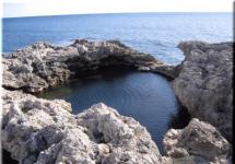
The main factor in the formation of the abrasion shores is the destructive work of surge waves, as a result of which the deepening is formed at the base of the slope - warbor niche. Over time, this niche is increasingly deepened, the hanging parts of the discovery fall into the sea, while becoming a mass of fragments, with the help of which the robust waves continue to continue the destruction of the coastal yield.
The creative work of the sea is expressed in the accumulation of materials dropped by sea (sand, pebbles, marine shells, etc.). Pebbles and sand on the surface of the abrasion platform are constantly moving within its limits under the influence of the surf. As a result, the form of relief of accumulative origin is created.
As a result of the multiple change of the depth of the ocean into glacial and intergaren eras, coastal zones Seas formed a kind of relief forms, which are called ancient coastal lines. They can sometimes be located on land and correspond to the position of the sea higher than at present. Ancient coastal lines corresponding to a lower level are now flooded by the sea.
Raised coastal lines are expressed in the form sea terrace. These are steps stretched along the coast.
Each terrace is allocated: the surface of the terrace; ledge; brocci; rear seam.They fix the position of the ancient coastline.
Depending on the structure, allocate:
- Accumulative terraces, that is, completely folded with coastal sediments;
- Abrasion terraceswhich are composed only by indigenous rocks;
- Ground terraceshaving a native base, blocked by sea sediments.
To identify the history of the development of the coast, the so-called spectra terraces,which make it possible to make a comparison of various sections of the coast and contain information about non-stocking movements.
Types of coast (byD. G. Panov)
(A - Ricasova, B - Fiori, B - Schoch, Mr., D - Dalmatinsky, E - Watte (1 - Watts, 2 - Loafers of the Stoke), Well - thermo-abrasion, z - coral, and - volcanic).
Literature.
- Smolyaninov V. M. General landland: Lithosphere, biosphere, geographic shell. Educational and methodical manual / V.M. Smolyaninov, A. Ya. Nemykin. - Voronezh: origins, 2010 - 193 c.
Abrasion is the destructive work of the sea. Select mechanical (basic), chemical and thermal abrasion. Mechanical abrasion occurs under the action of mechanical blows of waves and inhale fragments. Chemical abrasion is the destruction of shores composed of soluble rocks (carbonates, sulfates). Under the action of salts, carbon dioxide contained in chemically aggressive sea water, there is a dissolution and leaching of rocks. Thermal abrasion takes place mainly in polar zones on the shores of the seas folded with loose multi-member rocks or ice. Here, the shore is destroyed not only under the action of the mechanical energy of the waves, but also as a result of the fact that the temperature of sea water is above the temperature of frozen rocks, and the latter are thawed, break down and are destroyed. Chemical and thermal abrasion are always accompanied by a mechanical, which ultimately is the main one.
Abrasion takes place most intensely on the rotten coasts, i.e., where there is a steep underwater slope. Then the waves are suitable for the shore, without wasteing of their energy, as it happens when tipping the waves on the shallow shores, and all the kinetic energy of the waves goes to the destruction of the coast. At first, the sea drill at the base of the sea is formed - an abrasion, or a volitional niche, and then, with further recess and challenge the cornice of indigenous rocks, a steep abrasion ledge is formed, or cliff. If the shore is composed of solid rocky rocks, then a large chip material formed by their destruction remains at the foot of the cliff, and less large reverse flows are taken out into the sea and postponed on the underwater slope, gradually forming a underwater accumulative terrace. As the cliff is destroyed and its departure in the depths of sushi before it fit is formed weakly oblique towards the sea or the horizontal abrasion platform - Bench (Fig. 17).
Fig. 17.
Depending on the climate, the geological structure and the latest tectonic movements, the ratio of marine and subaeral processes is distinguished by many types of marine coasts. The most characteristic types of coarse are the following (Fig.18):
1. Lovent shores are characteristic of low-lying plain coasts, launching. Limans - bays, straight or winding in the plan, with low shores, resulting from flooding by the sea (or lake) of the mouth of the plated rivers and beams. Characteristic, for example, for the north-west coast of the Black Sea.
2. The lagoon type is formed in those cases of the evolution of the coast, when the bays, the limans are separated from the open sea. Entrance to the bay, in Liman can be blocked after the formation of a braid and turning it into the peresya, which connected the opposite sides of the bay. The formation of the bar on the canopy underwater slope and the hareage of it to the outstanding protrusions of the coast leads to the formation of the lagoon. Laguna gradually chewed at the expense of the proposals entering it. The source of admission of nanos is the river, before the mouth of which the delta is formed. Then the nanos are brought by tidal currents through the ducts in the bar.
3. Fjord shores are characteristic of high-grained areas cut away from the narrow deep bays - fjords, which are flooded by the sea of \u200b\u200bglacial valleys. The length of the fjords is dozens and first hundreds of kilometers, they are far away from the shelf, the width is the first kilometers, the depth is hundreds of meters. Many of them are straightforward, since it is confined to break disorders, others have a branching form. All of them have steep, rocky abrasion shores. Fjords are characteristic of the shores of Northern, Norwegian, Barents Seas, the coast of Alaska, Canada, Iceland.
4. Ricas coasts are formed when flooding by the sea of \u200b\u200bthe mouth of the river valleys in the mountainous areas. Rias are long narrow winding bays resulting from the ingression of the sea in the mouth of river valleys. Developed in the north-west of the Pyrenean Peninsula, the coasts of China, Korea, Primorye, southern Sakhalin Island, etc.
5. Ski shores are also associated with glaciation. Schhers are small rocky islands and underwater rocks, smoothed by a glacier ("Curchay"), which are flooded with a shallow sea large "Barani Hrafts". Sometimes the sea flooded and accumulate ice and water-glaciers - DRONLIN, Kama, Rimes. This type of shore is characteristic of Finland, Sweden, Norway, Alaska, Canada.
6. Dalmatian type of coast is due to the peculiarities of the geological structure. It represents flooded folded structures, extending usually parallel to the shore or space relative to it. In this case, the anticline protrude in the form of peninsulas and islands, and the bays are timed to the syncline. And the islands and the bay are elongated along the coast. The coast has a cut character. An example is the Dalmatian coast of the Adriatic Sea.
Fig. eighteen Types of coast
In addition to the above types of coasts, there are plenty of other - delta, volcanic, biogenic, thermal abrasion, etc.

(Lakes, Rivers), are called the shore.
The shores are divided depending on their steepness (sloping, incisive) and the nature of the components of their materials (or strong, sandy, pebble, stony). From the side of the water area, the seabed is adjacent to the shore, which is constantly experiencing the effects of water wave movements. This strip is called an underwater coastal slope.
Coast and underwater coastal slope together form coast zone of the seaWith which the complex interaction of the lithosphere, the hydrosphere, the atmosphere and the biosphere is constantly carried out. For this zone, the impermanence of the form of relief and their various combinations within the limits even small in the length of the plots. The work of seawater is manifested in the destruction of the shores - abrasionAs a result, they are departed into the depths of sushi, as well as in the sediment of destruction products - accumulation, which leads to a change in the underwater terrain of the coastal zone and to the formation of new types of coast. The shores formed mainly as a result of the destructive work of the waves are called abrasion, and the shores created by depositing the nanos are accumulative.
The main factor in the formation of the abrasion shores is the destructive work of surge waves, as a result of which the deepening is formed at the base of the slope - warbor niche. Over time, this niche is increasingly deepened, the hanging parts of the discovery fall into the sea, while becoming a mass of fragments, with the help of which the robust waves continue to continue the destruction of the coastal yield.
The creative work of the sea is expressed in the accumulation of materials dropped by sea (sand, pebbles, marine shells, etc.). Pebbles and sand on the surface of the abrasion platform are constantly moving within its limits under the influence of the surf. As a result, the form of relief of accumulative origin is created.
As a result of a multiple change of the depth of the ocean into glacial and intergaren eras, in the coastal areas of the seas, a peculiar form of reliefs were formed, which are called ancient coastal lines. They can sometimes be located on land and correspond to the position of the sea higher than at present. Ancient coastal lines corresponding to a lower level are now flooded by the sea.
Raised coastal lines are expressed in the form sea terrace. These are steps stretched along the coast.
Each terrace is allocated: the surface of the terrace; ledge; brocci; rear seam.They fix the position of the ancient coastline.
Depending on the structure, allocate:
- Accumulative terraces, that is, completely folded with coastal sediments;
- Abrasion terraceswhich are composed only by indigenous rocks;
- Ground terraceshaving a native base, blocked by sea sediments.
To identify the history of the development of the coast, the so-called spectra terraces,which make it possible to make a comparison of various sections of the coast and contain information about non-stocking movements.
Types of coast (byD. G. Panov)
(A - Ricasova, B - Fiori, B - Schoch, Mr., D - Dalmatinsky, E - Watte (1 - Watts, 2 - Loafers of the Stoke), Well - thermo-abrasion, z - coral, and - volcanic).
Literature.
- Smolyaninov V. M. General landland: Lithosphere, biosphere, geographic shell. Educational and methodical manual / V.M. Smolyaninov, A. Ya. Nemykin. - Voronezh: origins, 2010 - 193 c.