Choban Kule is one of the famous sights of the Sudak region.
A few centuries ago, on a small humpback of the cauldron not far from Solday (Sudak), the construction of the fortress unfolded. The instigator of this construction was the family of di Guoisco. The head of the family - Antonio, the native of the city of Genoa, and the three of his adult sons entered the story as tyranans and gangsters. The oppression of the local population and the open confrontation with the consul of the Schedule is confirmed by several documents of that era.
It seems that the fortress was not built to the end. Only part of the main fortress tower is preserved to this day - donzhon. And what was the founder then, in the 15th century, we are unknown. The name of the "Choban-Kule" - the shepherd tower - he consolidated after her after the invasion of the Ottoman Empire in the Crimea (in 1475).
Although close to Sudak is the Choban Kule, but I rose for the first time to her very recently.
Inspect the Chobane Kule is the easiest way to residents and guests of the village of Sea. The shore in the area of \u200b\u200bthis village stretched out the smooth line from Cape Ai-Fock to Cape Agira. In my records already there, which closes the bay from the east. And on Cape Agira, a little outstanding in the sea from the opposite side, in the West, I did not go before.
In December, my friends and I got to go towards the southern bank of the Crimea, and I, taking this opportunity, offered to make the Choban Couple by the first point of the program.
The path from the seashore to the Choban Kule leads along a rather steep slope. But this lifting does not take much time. There is a more gentle path - from Pine, just north of a hill with a tower.
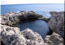
Having risen over the sea, I was surprised - what it is shelkovoy today! Such tender and cold ... And small waters of water at the shore - as if thin white lace. Ay-Fock, Karau-Ba and Megan ...
I first climbed into a dilapidated tower wall. It is interesting that the thickness of the wall changes: with the northeastern sides, it is twice as much as in the rest of the tower.
The monumental donjon survived the base, the first and partially the second ground floors. Now the height of the tower reaches nine meters, it is necessary to assume, it was at least a meter three or four above ( quote from here).
Over the past decades, the shore and long wild beaches under the Choban Couple became a popular destine site.
Popularity and accessibility is usually a negative side. Unfortunately, the Choban Kule is strongly written in inscriptions and inside, and outside ...
View from the tower to the east:
View of the West:
View from the south side:
View from the north:
In the 15th century, the castle di Guoisco would have to become an extreme western stronghold of the Sudak Consulate. But the unprincipled behavior of the Di Guoisco brothers and the powerful offensive of the Turk-Ommans prevented this plan. The unfinished fortress came into decline. And a small settlement, located under the walls of the fortress, disappeared from the face of the earth ...
We, not archaeologists and not historians, it is difficult to imagine how the castle di Guoisco looked like - with turrets, defensive walls and an adjoining shopping courtyard - more than five hundred years ago. Now we see here only blurred hills and dilapidated donjon rains ... But, anyway, this landscape is a valuable replenishment of piggy banks!
Ruins of the fastener fence:
Go back to the shore. Cape Megan is no longer visible, a cloud wave swept him.
On the shore groves the grinding machine! How many fruit they dropped!
Apple's muzklura (Adamo Apple), Sem.Tuty - This is a leaf fall, usually a high tree, in which interesting fruits ripen in the fall. They are inedible, used only in folk medicine (for the treatment of joints, with varicose veins, radiculitis, rheumatism, etc.). A heavy fruit, inside of which small seeds of nuts are hiding, during injury, a white sticky liquid is distinguished. In my opinion, the Mascura looks great in nature and parks. Distributed with round "apples" branches of the tree look very elegant! And the close "edible" relatives of Muclura are figs and a silk.
Another historic object, but not as old as Choban Kule is a former wine cellar. Such storage facilities are near Sudak, for example, in the valley of Kapsel. The cellar was often built near the vineyards, in the slopes of the hills.
Inside empty, only stupid inscriptions on the walls here as here.
We were detained in the pine tree under the Choban Kule. December was a mushroom month! Someone has already passed here, leaving the pristine "conditional edible" raw materials. Masha and Lénya decided to still collect them and cook (after cooking raws lost a caustic taste). In addition to the chewing, the oil and sulfur fell into the pine forest, if I'm not mistaken.
Return to the machines.
The familiar silhouette of the Choban Couple, which is visible from the highway: the round tower with a "stool" at the top ...
Opposite the hillock with the tower, on the road - a fork. You can turn to the north and go to Zelenogorier ,. Beauty there is known! But, this time we go further along the South Coast Highway, to General, and from there - on foot to the Jur-Jur waterfall! I hope to catch it very full.
Road loops, climbing one of the coastal hills. We stopped: I wanted to look at how low clouds come from the east. Choban-kule is no longer over black, but over the White Sea ... The mountains of Sandyk and the Pilla are visible in the distance.
Southeast Taurida is lighted among the seaside rocks and the mouth of small rivers. And the district of Sudak is generally curious in shape and relief of the coast in the Crimea. Cape Choban Couple in this regard is most unique. Photo and tourist reviews It is said that he looks like a tower - that is why the Crimean Tatars called him "the fortress of shepherds." The ruins of an ancient bastion are also really preserved on its top. In addition to shepherds, artisans lived here - the remains of their necessary products are found everywhere.
Where is the cape in Crimea?
The protrusion of the sea shore, which is in question - this is part of the Sudak City District, the territory between and the mouth of the rivers will east. The lower course of the latter in the coastal part is a conditional administrative border with a large.
Choban Kule on the map of Crimea
The history of life at Cape
It is not worth rallying this toponym - no local shepherds, but the Genoese merchants, were built - Choban Kule. The conversation is about the brothers Di Guoisco, who appeared near Solday (current perch) in the XV century. A small castle, built of raw brick, had the name of Tasil. The ears of medieval chroniclers reached rumors about the brown moral moral of these perky Italians.
In fact, they fought with neighboring ordinal (Crimean Tatars, Greeks and other Genoese) for land, cattle and slaves. As for the slanes, everything is very explained - the locals are valued by the skill of manufacturing ceramics (round-bottomed ovoid amphol, pyfhos and flask). Dozens of remains of pottery furnaces and thousands of fragments of diverse dishes are found archaeologists.
This Craft Center is rooted in the VIII century - the time of resettlement of multinational artisans. Products of Goncharov Boyko dared with Byzantine bezs and bazaars. The last site of the rise to the remainder of the citadel is not particularly convenient. For this reason, Cape in Starin called Agira ("Heavy"). Today, the tower is safer to pass a little bypass - through a canopy pine grove.
Features of a tract visit from the tower
On the map it is clearly seen - in the east, Cape occupies space from the place where R-29 turns sharply to the north-west. Consequently, to this historical "reserve" you need to start moving through a robustist barely in the thickets. Travelers move along quite a tolerable road. In its path, they cross the slope with the vineyard and located a little further than a small grove, located as if on the steps.
Below will be, on the one hand, a small wasteland, on the other, there are several paths leading directly to the sea. Lovers of local history At this point are usually turning to the West - to the "Shepherd Fortress" Fort (Tasili). From the largest donzhon, it remained very decently - 10 m. Di Guoisco detachments from here went to the robbery raids on many farms of the soldier community.
In the above location, many human bones were detected with explicit traces of damage. The tower and its surroundings are officially recognized as a historical monument. The complex is protected by the state.  There is on the local seaside patch and camping, which knows all and many experienced tourists. Car wanderers come here with trailers.
The shore is more large, and in some places and frankly rocky. There is no flat strip here even by the sea. No shoes on the beach is not recommended. Previously, directly from the water in the castle of the di Guoisco brothers won the tunnel. They say, he was blown up in the middle of the 20th century ... It is worth considering that Cape Choban-Kule is. Here you can not worry because of the cramped or appearance of your bathing suit, as well as about the lack of clothes at all.
Under the eastern sole, the sights of Sudak runs the same stream. In the sea, it flows just on the territory of the campsite. From the last to the village of Sea, where you can replenish the supplies, go 4.5 km along the shore (meant the path to the bus station). From the town road and the track to get out almost as much.
How to get to Choban Kul?
Achieve the described object easily. The road to the cape starts from P-29, behind the first river bridge after the marine bus station. To the coastal slope of Cape, it is necessary to go 450 m. To the Choban Couple Tower - another 300 m winding primer running up.
For better orientation, we also offer a route on the map, which will help you get to Choban Kule:
Tourist on note
- Address: Sea, urban district Sudak, Crimea, Russia.
- Coordinates: 44.811296, 34.746083.
Cape and the Chobane Kule Tower in the Crimea are interesting as a secretive swimming seat and a quiet tent parking, as a space with many historical attractions and as a low sightseeing area. Attractive lying around the picturesque landscape and pure azure sea. Near them, you can find the ruins of underground strokes and vintage wells of the VIII-XV centuries. Not far from the castle, the enthusiasts folded his reduced copy from the boob stone. On her background there will be excellent frames for a memorable photo collection. However, sometimes there is still not such masterpieces of Land Art.
What kind of castle and the surrounding area were worn, unknown. Only name in Tatar language is known. Shepherd Kale is translated from the Tatar language as a "shepherd fortress" or as a shepherd-kule "Shepherd Tower."
Geography
Shepherd Kale is located near the village of Marine, near Sudak. In the same area there was a source of Chaban-Cale-Chokrak, from whom he went on the hand joints of Chaban-Kale-Yozen.
Archeology
In the village of Slava, the pottery viii-IX centuries were discovered in the village of Sea (where also Shepherd Kale). The furnaces were embedded in a towering slope and composed of raw bricks. They produced mainly round-bottomed ovoid amphoras, flat-bottom vessels, round flat flasks and pyphhricas for sale throughout the Crimean coast, where pottery was required.
From the castle XV century The Guoisco brothers remained only the round sentiment (DONZHON) and at its footing remnants of the walls. In addition, parts of residential buildings were discovered, which accounted for earlier the village with the castle.
Notes
Literature
- Andreev A. R. History of Crimea: a brief description of the past Crimean Peninsula. - M.: Interregional Center for Sectoering Informatics of Public Administration of Russia, 1997. - 97 p.
- Keppen P. About the antiquities of the southern shore of the Crimea and the Tauridian Mountains. - SPb.: Imperial Academy of Sciences, 1837. - 409 p.
- MERS V. L., Kirilko V. P., Lysenko A. V., Tatar residents S. V., Teslenko I. B. Studies of medieval fortification of the shepherd-kule // Archaeological studies in Crimea. 1994. - 1997. - № 1. - P. 200-208.
- Shilik K. K. About the magnetic separation of pottery stoves at Shegna-Kul // Brief messages of the Institute of Archeology. - 1974. - Vol. 140. - P. 115-120.
- Jacobson A. L. Medieval Crimea: Essays of the history and history of material culture. - M.-L.: Science, 1964. - 232 p.
5 km from the village of Marine, in the area with. Love, the Cape Agira is located, on which the medieval tower "Sheban-Kule" XIV is XVVV., Which means "the shepherd tower". She surrounds the remains of ancient buildings and defensive walls.
The tower is composed of sufficiently massive stones and pieces of rock. Walls reaches thickness of 2-3 meters. Its height is now approximately 9-10 meters. The entrance to the tower is located from the southwestern side and is very destroyed.
The upper part of the tower is destroyed, mostly probably due to tourists.
Inside the tower, in the wall, there is a sufficiently deep niche with a hole outside, the purpose of which can be the most diverse. Preserved fireplace and water pools located in the basement.
From the eastern side of the tower, the remains of defensive walls are still visible, for some data, a temple was located near the tower. Massive ruins at the foot of the tower bear the outline of certain buildings.
Notice inaccuracy or data are outdated - make corrections, we will be grateful. Let's create the best encyclopedia about the Crimea together!
5 km from the village of Marine, in the area with. Love, the Cape Agira is located, on which the medieval tower "Sheban-Kule" XIV is XVVV., Which means "the shepherd tower". She surrounds the remains of ancient buildings and defensive walls. The tower is composed of sufficiently massive stones and pieces of rock. Walls reaches thickness of 2-3 meters. Its height is now approximately 9-10 meters. The entrance to the tower is located from the southwestern side and is very destroyed. The upper part of the tower is destroyed, mostly probably due to tourists. Inside the tower, in the wall, there is a sufficiently deep niche with a hole outside, the purpose of which can be the most diverse. Preserved fireplace and water pools located in the basement. From the eastern side of the tower, the remains of defensive walls are still visible, for some data, a temple was located near the tower. Massive ruins at the foot of the tower bear the outline of certain buildings. Save changesBeaches, crowds of cars, billions of tents, umbrellas and mattresses, and even more human bodies scattered around the beach ... not horror and thriller, and rest was the place of Choban-Kul, near the village of Maritime, the Sudak City Council. And all this female recreation is crowned for a long forgotten tower at Cape Agira. Choban-kule her name what means "Shepherd Tower". The appearance of this construction is associated with Gotami and Byzantines.
The famous tower was thanks to the Genoese feudalities - the brothers Di Guoisco, who owned the castle in the 1470s. The Guoasco Brothers (Andreotti, Dimitri and Theodoro) captured the village of Tasil and Tasili (Romovka), belonging to the Soldier (Sudaksky) consulate, and had cruel orders here. In the brothers who are visited to intimidate local residents installed the gallows, and on the border of their possessions - a shameful pillar. All the intentions of the consul pacify the self-government of the Guoisco family ended to no avail. The conflict stopped in itself with the Turkish conquest of this place in July 1475.

A partially studied complex consisting of a castle and a small settlement with his XV century temple is a rare historical and archaeological material. Thus, the Donjon can be distinguished (the place of residence of the Guoasco brothers), surrounded by an external perimeter of walls and towers, as well as tangent to him by the courtyard protected by a massive stone wall of clay.
Construction Strengths skillfully used the protective properties of the area, but the fortification features of the relief are clearly departed into the background when constructing the geometrically correct polygonal walls of the fortress. The upper part of the hill is occupied by the fortifications, buggy. Donjon occupies one of the heights. The second peak is located in the north-west. If you want to know everything about the Crimea, I recommend buying a site.

Such a dangerous neighborhood from the standpoint of strategic feasibility as a defining factor in the placement of fortifications is completely illogical. It also remains incomprehensible and non-functional adaptation of a south-western loan, which could only control a small space along the Kurtin. Perhaps this is just not brought to the end of Esplanade, which could compensate for the negative properties of the relief.
The protective properties of the fortress clearly demonstrate the brainits of the footing of the corner towers. They were in the lower tier of the building and were designed for the flanking of the space at the foot of the Kurtin. All three preserved brainits of the same type. Their characteristic feature is a device with an outdoor part of two vertical vertical on one axis of holes. The brainits of this type in the fortifications of the Crimea are a unique phenomenon. Probably, if you hold a parallel between the Barbakan of the Sudak Fortress, it can be assumed that these were the drains dated XVII century.
From the west side of the tower, the remains of defensive walls are still noticeable. Not far from the tower, according to the testimony of archaeologists, there was a temple of the XV century. Massive ruins somewhat resemble the platform of the building.
At one time, Choban-Kule explored scientists who carried out excavations. An interesting thing was a discovery when clearing the masonry of the curtains. Between the stones, in the niche, which was formed as a result of the collapse of the stone, a compact accumulation of objects was found. Here are five plates and nine arbal arbulent arrows. The tips lay on the plates without any specific system, bushings and heads in different directions. The products strongly blended corrosion, even traces of fabric reflected on the surface of one of the plates.

Also discovered traces of an underground move, which led to the foot of the cape. Unfortunately, he was blown up in the middle of the twentieth century.
In the VIII-9th century, Choban Cole was a big potter center, as evidenced by the remnants of pottery stoves and ceramics breaks.
Perhaps it is incorrect to think that there are no tourists here. The tower is simply teeming with those who want, the main mass is made up of tourists under the castle cape. They are just the protusive paths, Crimean paths to the magical world of the past.