Forming an abrasion cliff with a height of 45-60 m.. Throughout three kilometers between capes, a large and small atlash was formed by weathered in limestones a variety of original nozzles, coves, sea grots and sea caves, abrasion arches and remains. In one of the gorges found a colony of fossil oncolites. The attachment surface of Athlesh is occupied by Petrophite Stepha. Since 1968 Athlesh - Reserve tract (10 h.).
origin of name
Athlesh name comes from the Persian word athech (fire). The name is obviously due to the fact that since a long time on the coast of climbing rocks, fires laid out, which in rainy weather and at night indicated ships to the shore. The rocks of Tarkhankut are very dangerous for navigators, and coastal waters can quite compete with the waters of Sevastopol and Kerch in the number of sunken vessels. At the same time, with ancient times, the small bays of Athlesh served as a reliable shelter for pirates and smugglers.
sights
- arch of Big Athlesh - symbol of Tarkhankut;
- through 98 meter tunnel;
- half-filled 150-meter cave;
- "The bowl of love" is a place of pilgrimage of lovers;
- the picturesque coastal cliffs, where the films "Taman", "Man-Amphibian" movies, "Pirates of the 20th century", "People and Dolphins" were filmed.
Description
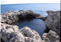
It opens an extraordinary beauty picture: snow-white 40-60 meter coastal cliffs, yellow beaches in small cozy coves, sky blue and sea, greenish-white caves and grottoes. The coastline here is bent around the arc, forming small bays. It is difficult to imagine, but white rocks, the deposition of limestone is the bottom of the ancient sea. Here you can trace how sedimentation was accomplished (the process of deposition at the bottom of the sea, the lake residual organisms having lived at the bottom and in the water mass, as a result, over time, sedimentary rock is formed from these residues) in a remote geological past. Plots cliffs located above sea level, younger. Freshly towering over the water separated from the shore of the boulder. One of these rocks is called "Turtle". The western tip of the Bay of Athlesh in the sea is the rock, in which the waves and winds are sticking out huge Arch - Symbol of big atlas. It leads the metal staircase, which was built quite recently. Not far from the arch is breaking into the sea another two-hours staircase, which unknown creators were cut in limestone in a long time. It was on it that the main heroine of the movie Taman (according to the same name M. Yu. Lermontov) went down to the boat.
The lower part of the stairs collapsed the waves. Not far from the arch is a grotto that has a peculiar form. The episodes of the filibulations "Pirates of the XX century" were filmed here.
Athlesh is divided into two parts: large (located in 6 kM Southeast of the reindeer fellow) and small (kilometer from Big). The coast between the big and small atlesh is replete with stone canopies, grotes, niches. The bottom of the sea is born with bizarre little blocks treated with waves.
At Malom Athlete attracts the attention of the Giant 98-meter tunnel, punched by waves in the thickness of the cape. The height of the tunnel from the water level to the vertex of the arch 8.51 m., crop thickness - about 10.7 m.. This is an amazing natural education, the journey in which the spirit captures. The hero of the film "Pirates of the 20th Century" passes through this tunnel to the Pirate Island. In the upper heap of the tunnel is "purified", in other words, the end-to-end well on the surface of the Earth, which refers to the researcher K. F. Kessler (see below). It can be seen by sailing along the tunnel itself. This fascinating journey can be made on a small boat, an inflatable mattress, or climb.
From above, the area where the well is located is not fenced, so it's better not to approach this through hole.
Next to the entrance to the tunnel is the lowest in Crimea 150-meter, known to those skilled in the Crimea, but not yet studied cave, entrance to it by 10 m. below sea level. She ends with a small hall. To get into it, you need to sail about 5 m., in the place where the arch hits almost over the water itself. When the arch of the cave becomes higher, you can freely swim it up to the very end, to the miniature sandy beach. You can only go to the cave only in quiet weather.
The famous is the so-called bowl of love, it is surrounded by natural cliffs. The depth of the sea here reaches 6 meters. With the open sea, the bowl of love is connected by a small underwater tunnel. The main character of the amphibian man's film - Ihtyander - hit him in his father's house.
People's belief explains the name of this picturesque area like this: before married the local young people should have verified if their union would be lasting. Holding hands, they jumped together into a bowl of love. If their hands open under water, it means the marriage bonds will not be durable. If not - the Union will be strong.
From a long time, this plot was chosen fishermen. Atlesh shores are a magnificent autumn and spring progress of Kefali and Mackerel. On the territory of Big Athlesh and currently there is a fishing mill. One of the researchers of Tarkhankut P. D. Podgorodetsky, in his book "North-West Crimea" gives a description of the catch of fish with the help of the original seven-detection device "Karavii"used for fishing fish in the XVIII-XIX centuries. Karavii was installed at the shore during the autumn and spring stroke of Kefali and Mackerel. The main part was the huge rectangular network of "Kest" (a boiler), which was held on the ropes fortified on the pile ridges driven into the seabed and spread over the shallow bottom of the sea. Three edges of the network were raised to detain in her in her, and the fourth lay on the day. Two fishermen, leading continuous monitoring of the sea from special sites, warned about the approach of the fishes. After the fish entered the network, the fourth side was raised quickly. Reliki came immediately to the network, and the fishermen were chosen by large drawers.
Fisherover fishing in Tarkhankut KF Kessler, who visited K. F. Kessler, who was here in 1858. He wrote: "Two cheefalievable plants are arranged on the Karadzhinsk land, of which one, called flight, is located on the south side of Tarkhankut and will be from Karadi for 7 miles. Other, Charojsky, is located on the north side, in the distance of 4 miles from Karadi ... The flying fishermen at the same time they had a caught fish on their shoulders to stick up a cool and dangerous staircase, but the last Ataman came to punch a wide one It is thoughtful to the tunnel, and this greatly facilitated the work of fishermen. Now the boats with fishes enter the tunnel and there they dump it into large baskets, which by means of the gate with ease are pulled out through thought to the surface of the earth. "
In 1966, athletes of enthusiasts were visited at the Athlete of the Club of Lovers of Underwater Research "Ithyandr". In a special house, which was adapted for a long immersion under water, they conducted studies related to changes in the human body with a long stay at depth. The doctor A. Haes and Engineer D. Galaktowon were held under water along three days. Not far from the place of the house of the house, a limestone stone was preserved, on which carved words remained: "Donetsk. Rytnandr. Immersion location underwater house. August 23, 1966. Unfortunately, a significant part of the inscription erased time, and it is difficult to read.
In the Athlesh area, water is clean and transparent. Surprising and unusual creation under water were created here and people. This is a museum at the bottom of the sea, the Underwater Gallery of the Busts - Alley of the leaderwhich is located a hundred meters from the shore on a 12-meter depth. The scuba launches were intensified in the stones of Lenin, Kirov, Dzerzhinsky ... near the table, which was recorded that the museum was opened by Vladimir Boruman 25 August 1992. Then the first bust was installed. His undertaking was supported by scuba friends. Near the busts of revolutionaries, sculptural images of cultural figures, writers, poets, composers appeared. With interest peering into familiar faces: Pushkin, Yesenin, Dobrolyubov, Beethoven, Block, Mayakovsky, Tchaikovsky. And around - the jams of the block, smoking algae, mussels. Simferopol filmmakers shot a film about this amazing and unusual museum. This underwater museum is no longer anywhere in the world.
The athlesh territory attracts not only lovers to relax, sunbathe and swim with scuba. Scientists come here: archaeologists hydrologists, biologists, paleontologists. Tarkhankut can rightly be called an inexhaustible storeroom diverse scientific discoveries. So scholars-paleontologists in one of the limestone's outcrops found an imprint of fossil fish inhabited in a distant geological past. Fish length - more than 1 meter. Another unique find is a colony of fossil oncolites (round limestone reasons) - the sizes of individual copies reach more than 40 cm in diameter. Such a paleontological museum at Athlete.
How to get?
From a reindeer shooting on Athlesh leads a dirt road along the sea. In some places it is branched, but it is necessary to stay the coast so as not to circle along the steppe spaces. The driving part recesses the protrusions of limestone of various sizes, so it is necessary to move very carefully.
It is definitely necessary to stockpower to drink water, as there are no water sources in the final point of the route. However, these and some other inconveniences do not scare away lovers of "wild" rest.
After 15 minutes (when traveling on a car) or an hour (when moving on foot), you will get from the reindeer fellow at the big atlash.
Even in densely populated areas, the corners intact civilization are often preserved. Large and small atlash in the Crimea is an example of such a protected area near popular resorts.
Where is the tract on the map of Crimea?
It is located on the West Bank, southeast of the reindeer fellow. In the vicinity, you will find the bay asylum and the island remains of the turtle.
Origin and History
The peninsula is generally considered a unique Crimean natural corner. The name of Athlesh is the two of its cape - respectively, large and small, as well as the tract between them. The shore here is almost drowned, but composed of soft rocks. For many centuries, water and wind gave them a bizarre form with "stairs", grotes, caves and arches.
Rest on Earth here is little possible - there is no shadow around a naked steppe. Well, since 1968 Athlesh is. So inspect it more often during sea excursions, and if you come on land, it is rare for a long time.
Lighthouse for smugglers
Another feature of Athlesh is a significant depth. As a result, here have long been engaged in fisheries, and it was important to be able to be able to be able to find a tract at any time of the day and with any weather - Tarkhankut is quite dangerous to the seurrets. Therefore, the fires often focused on the shore, which could serve as a guide.
In addition to fishermen, smugglers often came into small secluded bays and other violators of the law. And their fiery landmark gave the name of the terrain - "Atsh" translated from Persian means "fire". Accordingly, scientists believe that the local shore is mastered and was actively used by the navigators in the ancient times.
The unusual landscape of Cape Athlesh repeatedly attracted the attention of cinematograms. Here they filmed such ribbons as "Pirates of the twentieth century", "Taman" ,. Directors did not have to strain props - the terrain equally successfully "played" and the very thing (that is, the Black Sea coast), and the island in the far ocean.
In the area of \u200b\u200bthe village, experiments were carried out to determine the influence on a long-term stay under a water thickness. To this end, in 1966, a whole residential module-house was lowered under it with the unoriginal name "ichyandr". Engineer D. Galaktionov and Dr. A. Haes as "experimental rabbits" held in it for 3 days each.
Athleshi - the recognizable "face" of Crimea
Athlesh landscapes are among the most famous and recognizable species of Crimea. They are often used to advertise recreation on the peninsula. Often, the rocks are inspected during the boats,  But on the shore, you can get here, and there is a lesson for such travelers.
Great Athlesh on Tarkhankut is known for the 40-meter arch made by the sea in one of the rocks. It is an almost official "calling card" of P-ov. It can be climbed - for this purpose, a metal staircase was recently built. There is a rock and the other - stone, she appeared in one of the episodes of Tamani, but now undergoes considerable destruction.
Small Athlesh permeated through long (98 m) tunnel. Small excursion boats must be sworn there. In the film, the tunnel served as a "secret passage" to the pirate base. Next to it finds the entrance to the lowest of the largest. It is impossible to see it with sea gladies - it is located 10 m below sea level. The total cavity length is 150 m. Traveler reviews - invariably enthusiastic.
Photo Arches and tunnel - a mandatory attribute of albums of those who visited Tarkhankut. If it was a romantic couple, then a picture is necessarily accompanied near the small reservoir on the shore, communicating with the sea underground collace. It was used when shooting "Human amphibian", showing the secret route of Ithyander from the house of the Father. Bathing in a bowl, according to belief, can ensure happiness in marriage,  If the couple decides to jump into it together and, moreover, will be able to emerge without breaking the hands.
Human hands also tried to create a storm attractions. There is a "fishing mill" at the MOPE, a peculiar recreation area (paid). The most noteworthy object is the Church of Nicholas Wonderworker (considered the patron saint of seafarers), built under the auspices of UNESCO. Next is also with an entertainment program.
But the most interesting man-made landmark is located on the bottom. You need to become a diver to visit - the underwater assembly of sculptural images of famous people (not only politicians, but also writers and musicians). The museum was created by V. Boruman in August 1992 (the corresponding explanatory sign is also under water). The name appeared due to the fact that at first the underwater exhibition had only images of the prominent workers of the USSR.
How to get there?
As a rule, they get here through a reindeer girl, reaching it to the city transport, and then to the end place either by the travelers, or with a hiking (although there is a fairly long).
By car, drive to the atlasms in this way:
Tourist on note
- Address: Tarkhankut Peninsula, Crimea, Russian Federation.
- Coordinates of GPS: 45.332109, 32.573837 (Small Athlesh), 45.335675, 32.552807 (Great Athlesh).
Small and large Athleshies in Crimea cause persistent interest among tourists - the charm of the pristine Crimean nature and the creative nature of the inhabitants of the peninsula is connected in this place. White remains are cut by water and wind, anyone can do the harder and cleaner! Well, in conclusion we offer a cognitive video video, pleasant viewing!
Esoterics appreciate Tarkhankut for his place of power. Divers - for transparent aquamarine sea. Kiteserfer - for the stunning wind. Cyclists - for excellent primers "up-down". Not trouble, if you are not a fan of scuba, sail or two wheels, be sure to go on the wild West of the Crimea on the journey. If you do not like, then at least all the sunsets will be yours!
1. Zakat in Olenevka
Tarkhankut: Where is it, how to get to, where to stay
The Tarkhankut Peninsula is the most western in the Crimea, here, as it is not difficult to guess, there is an extreme western point of the entire Peninsula - Cape Zada. Until 1953, Cape was called Karamrun ("Black Cape"), and the peninsula itself, by the way, was never renamed. Tarkhankut is translated as "angle (Kut), free from the filings (Tarkhanov)".
Tarkhankut systemically has not yet been studied by archaeologists, so there is a lot of riddles to this day. For example, a large number of ancient settlements says that two more millennia ago, the local land was comfortable for life. And numerous deep beams that cut the peninsula very much resemble the beds of parallel rivers than the simple soil erosion. Now there is a large deficit of natural water on Tarkhankut. In many ways, for this reason, this is one of the most unclosed areas of the Crimea.
There are several villages here, which can be reached by flight transport. The largest of them is Black Sea. Less is inter-water, reindeer fever and Okunevka. Because of the long distances on Trachankut, it is difficult to travel on foot. The optimal option remains a bike or personal transport with high suspension.
In all settlements of Tarkhankut, you can rent housing from local residents (for many of them, this is the only income). You can, of course, stay with a tent.
2. Steppe roads of Tarkhankut

Dzhangul my soul
Since Tarkhankut occupies a considerable area (only on the coastline - about 40-50 km), then, of course, it is very diverse to the relief of the peninsula. Geographers allocate even several zones on the coast. One of these zones is Dzhangul - has a very romantic translation from the Turkic language, namely, dear (beautiful) rose.
Dzhangul landslides stretch at 8 km along the seashore. Closer to the reindeer leaves more sheer, remind the chalk hills in Scotland from my English detectives. Here, Tarkhankut elevation is shifted by one of the other with almost parallel dry beams, with secluded covers.
3. Someone took the land for rent and built a small estate with a pier in one of the bays

4. Cretaceous cliffs of Dzhangul

5. Castel fortification in Bay Big Castel

6. On the walls of the ancient settlement

7. Work of the modern master

8. In summer, water in the sea is heated to 28 degrees in these places

Athlesh, big and small
South of the reindeer origin, the coast of Tarkhankut is called big and small atlash. This toponym scholars are associated with the word "athech" (fire) from the Persian language. Local residents have long been in rainy weather diluted fires to warn sailors about dangerous chairs in the area.
Here the shore is not so high, there are much more descents to the water. It was in the area of \u200b\u200bAthlesh, "amphibian man" was filmed. And Athlesh's business card is a few cross-cutting grots in rocks.
9. Random Relief Rock or Swipped Pottery Circle into Earth?

10. Scala-ship

11. Slight later sign the name when I define on the directory


13. Dolphinarium is located on this end-to-end

14. Layered Pieces of Tarkhankut Oppositions

15. This end-to-end grotto is so huge that a sailing yacht can pass through it

16. On top of the grotto, the element "weathered" the hole. I look inside - the sea is visible at the bottom

17. Approximately the previous frame was made. The territory around the hole is fenced in no coincidence, because the car has been stuck there!

18. One of the local attractions is the so-called bowl of love.

What else to look at Tarkhankut
19. Of course, the famous lighthouse and sank the cargo ship opposite him

Lighthouse at Cape Tarkhankut was built in 1816 by one of the first in the Crimea. In Built on the same project.
Dry cargo ship "Sirius", stranded 30 meters from coasts on the night of February 28, 2005. The team managed to save, and there is no ship. As a result of winter storms "Sirius" split in half, the nasal part sank, and the feed still drifts in shale.
20. Karavia

See four constructions in the sea? This tower of fishermen, which attached a special rectangular large-size network called kesne For catching Kefali and Mackerel.
Pile-tower ridges into the sea. Rocks are attached to them, unfolded along the bottom of the sea. Karavia A network lift is called in these places from the 18th century. Three edges of the network are raised above the ground, through the fourth shoals of the fish enter the net, after which the ondoor fishermen instantly raise the fourth edge of the kest.
And, of course, on Tarkhankut it is worth visiting the ruins of ancient settlement: and.
Perhaps the most sign attraction can be called a huge grotto. Its height reaches 9 meters, the depth is about 100 meters. With such dimensions, a boat or even a sailing boat can enter inside without interference. Near a grotto at a depth of 10 meters below sea level is located the dream of each spele separator - underwater entrance to the cave, stretching almost 1.5 hundred meters. It is believed that this cave has a communication with another nature monument - a bowl of love.
Awesome Nature Athlesh, impregnable rocks, picturesque landscapes regularly attract here on excursions of numerous tourists, holiday in Crimea. Here, many people feel like literary or cinematographic characters. The impressions of these places will long be imaginable. Resting in the Crimea in the summer of 2019, be sure to visit Atlesh - it will be one of the most vivid events of your vacation!
The most needed and detailed information about the sights Large and Small Atlesh (Crimea): photo of places, description, contacts - address, telephone, official website. Attractions you can see user rating, read reviews, tips and recommendations. In the catalog of interesting places you can see the location of the sights of Large and Small Athlesh (Crimea) on the map, places nearby, where to eat near and what to see nearby. For some of the places you can find excursions, news and special promotions, as well as tickets.