South Chuisky ridgestretches in latitudinal direction from west to east for 120 km and is the eastern end of the southern chain of the Central Altai mountains. The South Chuisky ridge has clearly defined boundaries of its territory: from the west it borders on the eastern part of the Katunsky ridge, from which the r. Argut. The eastern border of the ridge is r. Tarhata is one of the sources of the Chuya River. The northern border of the South Chuisky ridge is the Karagem and Dzhelo rivers (Chagan river), which are also the southern border of the North Chuisky ridge. The South Chuisky ridge and the North Chuysky ridge are connected by their mountain spurs in the area of \u200b\u200bthe lane. Karagem. This is the so-called Karagem jumper. From the south, the Severo-Chuisky ridge is limited by the valley of the Zhasater, which separates it from the mountains of the Southern Altai.
From the main watershed line of the Yuzhno-Chuisky ridge, eight large spurs depart northward, serving as watersheds of the right tributaries of the river. Karagem (Tingedu river, Kara-Aira river, Atbazhi river, Ioldo-Aira river), left tributary Chuya (r. Kara-oyuk, r. Taldura, r. Chagan) and the sources of the r. Chuya (Yelangash river, Kok-Ozek river, Tarkhata river). The southern spurs of the South Chuisky ridge are the watersheds of the right tributaries of the river. Zhasater, which in turn is the right source of the Argut River (Bara River, Tyun River, Uzurgu River, Tangyt River, Arzhan River, Chikty River, Akbul River, Tara River, Ayut River, etc. .) and the river itself. Argut (r. Karasu). The southern spurs of the South Chuisky Ridge are shorter and lose their height more quickly than the northern spurs. Spellingly, only two of them have their own names: Taldurinskaya Ograda and Beltyrdu.
The Taldurinskaya Ograda ridge stretches from the main ridge to the north and, as it were, “encloses” the Taldurinsky glacier for which it got its name. The heights of the ridge are decreasing in this direction, the highest point is the Klyuch peak (3733 m).
The Beltyrdu ridge also extends to the north of the main ridge and divides the Akkol and Kara-Oyuk rivers, and at the same time the Sofiyskiy and Kara-Oyuk glaciers.
The ridges owe their names to the geographer of Tomsk University V.V. Sapozhnikov, who explored the area at the end of the 19th century.
The main glaciation carries the central part of the ridge from the valley of the river. Kara-Aira to the valley of the river. Elangash, with a sharply dissected topography and heights of up to 3700 m. On the flanks of the central part of the ridge rise the peaks of Iiktu (3936 m) and Tymomu or Irbistu (3967 m). The South Chuisky ridge is the second largest glaciation in Altai after the Katunsky ridge. In total, there are 243 glaciers on the South Chuya ridge, with a total area of \u200b\u200b222.8 km2, most of which are located on its northern slopes. The main glaciers are Oshtu-Airy, Bol. Taldura, Sofiyskiy, Yadrintseva. In terms of numbers, the South Chuisky ridge is dominated by the crust-type glaciers, and by the area - valley. Closer to the eastern part of the ridge, the relief becomes calmer, the saddles are more pronounced and smoothed.
The following features are characteristic of the entire South Chuisky ridge. First, the southern slopes are steeper than the northern slopes and have shorter spurs. Secondly, the glaciation of the southern slope is much less than the northern one. Thirdly, the ridge is very poor in woody vegetation, concentrated only along the valleys of the tributaries of the river. Zhasater and tributaries of the rivers Karagem, Taldura and Chagan-Uzun. Fourth, the climate of the region is much drier and more contrasting than on the Katunsky and Severo-Chuisky ridges. The snow line rises from west to east from 2900 to 3100 m, on the southern slopes it is 100 - 150 m higher.
The most convenient approach to the beginning of the routes passing along the Yuzhno-Chuisky ridge is by car from the north along the Chuysky tract. The starting and ending points of the routes can be the villages of Kosh-Agach, Mukhor-Tarkhata, Chagan-Uzun, Beltir, as well as the highway connecting the regional center Kosh-Agach and the village. Jazzator. Recently, rather difficult and lengthy routes have become popular, covering simultaneously the Severo-Chuisky and South-Chuisky ridges with access to the region of c. Belukha of the Katunsky ridge.
There is an erroneous opinion that sports categorical routes passing along the South Chuisky ridge should also pass along the Severo-Chuisky (most often) or along the Yuzhno-Chuisky and Katunsky ridges (less often). The classified tourist obstacles make it possible to plan completely logical independent tourist routes of almost all categories of difficulty along the Yuzhno-Chuiskiy ridge.
Route map. View from space
The route I proposed was designed for at least 12 walking days, without a bad weather reserve, but our trip was now organized for a maximum of 10 days, so it was decided to decide where we would go there and which route, depending on where we would go by car. Honestly, it didn't matter where to go, just to go.
With us in the group was one young man from the Czech Republic - Valentin. He is Russian, he has lived in Prague only for the last 3 years. Therefore, we can say the group was with a foreigner. But as he was brought up Russian, he remained so. Prague will not remake it.
 On July 2 I went to buy groceries, and on July 3 in the evening after work I packed my backpack, since we leave on July 4 in the evening at 20:30, and in the afternoon I was still working.
On July 4, everyone met at the station and went to board. The train to Biysk leaves at 20:30 local time. I took tickets at the end of June - the price is 333 rubles.
Real summer began in Novosibirsk in early July. In the evening, the train was +28 +30. Our window did not open, as there was an emergency exit, and apparently there were many places where they did not open in the car. When it got dark and the people began to fall asleep, sounds began to be heard from all sides (cracks) reminiscent of the loud whistling of night crickets and grasshoppers, and so on all the way to Biysk. So I couldn't sleep well. It was also hot on the train at night +24.
 The train arrived on July 5 at 6:20 local time in Biysk. There, at the station, we were met by a car, with which we agreed in advance. On the square in front of the station there was a huge number of cars and all taxi drivers. They deliver them anywhere.
Surprisingly, there were no GAZelles other than ours. It is strange somehow, last year there were a lot of Gazelles. While we were loading into the car, the station square quickly became empty, everyone left. Loaded into the car, as roomy in the six in the car.
We left the station at 6:37. The first kilometer pole outside the city showed 354 km. And we drove 6-8 kilometers from the station, which means about 345 km.
7:00 - 373 km of the Chuysky tract. +18 C.
Between 428 and 429 km is the border between the Altai Territory and the Altai Republic.
8:00 - 455 km - Lake Aya. There were many nebulae on the mountains in the morning.
8:35 - 497 km - Ust-Sema. Those. from Biysk to Ust-Sema to go in the morning for 2 hours.
9:00 - 527 km.
10:00 - 579 km - ascent to the Seminsky pass.
 We stopped at the Seminsky Pass for a few minutes, wanted to take a picture of the stella in the summer. There is a market open early in the morning.
11:00 - 632 km. On the outskirts of Ongudai there is a cafe "Fara" - this is for those who suddenly want to eat there in the area. 643 km - there is also a cafe on the right.
 We stopped at the observation deck at the Chike-Taman pass. On the descent from the pass we saw a freshly wrecked car, probably overturned. There is a gas station in Kupchegen.
12:00 - 675 km.
Before 684 km there are stones and mounds on the left. There is a beach at 692 km at the confluence of B. Yaloman with the Katun. There is now a new gas station in front of Rime. At 713 km there is an exit to the confluence of the Chuya and Katun.
 It's already lunch time. We stopped at the "Chui-Oozy" cafe, as something in White Bom is no longer hungry. There are always a lot of people there, they cook for a long time and everything smells of communism. This is not the case here. There are fewer people, everything in the cafe is new and beautiful, Altai music is playing, food is served quickly. after lunch I went to take pictures of petroglyphs, but to my surprise during the day they are very hard to see. When I was there in January, it was better to see them. But I found one that I had not seen in winter. I asked in a cafe what Chui-Oozy means, it turned out to be very simple - the mouth of the Chuya.
14:00 - 764 km. Stopped for those. inspection of the car. I went to Chuya to take pictures. And I found edelweiss here. I have long wanted to see them. But from all the information that I knew it was that they were growing somewhere near the White Bom on the mountain. And then suddenly near Chuuya. How lucky.
For some reason we stopped in Kurai. I don't remember anymore, but the photo speaks of a stop.
15:46 - Chagan-Uzun. Since I didn't really find out where the road to Beltir was, and according to the map it goes through Chagan-Uzun, we went there to look for a road.
 We found out that there is a road to Beltir, but we will not pass the GAZelle there, there the river needs to be crossed. Let's look for a UAZ, but the one found didn't go. They sent us to go to Beltir via Ortolyk.
In Ortolyk, there is a gas station right next to the road, we stopped in for gas and an UAZ drove up here. We were in Ortolyk at about 16:30.
 We began to talk with the driver about a transfer somewhere beyond the Beltir. He agreed to take us almost to the Taldurinsky glacier itself. I agreed to take it for 1500 rubles. Poured him 30 liters of gasoline and go.
There was a small child with the driver, then he fell asleep very quickly. Nothing unusual - the driver must be drunk, otherwise he will not get there. Well at least he didn't ask us for a drink. His eyes were red and piled up.
Now how to get to Beltir for sure: If you drive the entire Ortolyk along the Chuysky tract, at the end of the village there will be a sign to Ortolyk - to the right, turn off and go, there will be two bridges across the Chuya. The first 5 km of asphalt, then up to 17 km of gravel, and then up to Beltir itself up to 29 km again asphalt. Any car will pass.
 The road went further and further from the road and gained height. The places became wild and lifeless. Here is the Chuya steppe, like pictures from Mars, only the color is not red, but yellow. Stones, clay, sand and everything. And nothing else. there is no grass. Impressive when you first see it. There are no photos since they did not stop. Finally we got to Beltir.
The epicenter of the earthquake was here 30 kilometers away. The floor of the village was demolished, everything that was made of stone. The wooden houses are probably all restored. There is half of the village, but half is not. For those whose houses were destroyed, a new Beltir was built, not far from Kosh-Agach, and who probably did not want to leave live here. We stopped by the driver's ancestors, he left the child there and drove on.
The driver could not be silent, he tried to talk all the time. The main topics were 2: first, he tried to hint to us that everything here depends on him, and that if he wants that we can not go to the glaciers, second, he tried to prove to me that we are from a travel agency, and that I am here in this group is a guide, since I sat in the front seat and paid the money.
At the end of Beltir there will be a school stadium on the left side, after which the road turns left, and then immediately right to the bridge over the Chagan. moved across the bridge. There is a fork in the road, to the left along Chagan to Akkol, and we drove to the right along Taldura. The road along Taldur is only for off-road vehicles, you should not go there by simple cars. Don't get far. The car was overheating, especially did not want to get under way after a stop. At one of such stops, while the driver was putting wet mud and grass on the engine, he took a photo of the Taldura valley.
On the way, not far from Beltir, on the left cleavage, there was a camp of 5-8 tents. We passed a landslide after the earthquake. This is something incredible. I could not take a picture. On the slope of the mountain, a large area of \u200b\u200bforest, probably 150x150 meters, slid down the slope for several tens of meters. Incredible.
The road was quite bad in places, questions are already popping up: will we go further or not. But there is no better UAZ for these places. We arrived at the Dzhelo river at 19 o'clock, and our Altai man said that he simply could not go further, there was a bad road, and that he would not even cross the river. I had to unload, especially since I had long wanted to get out of the car and even walk. We paid him the remaining 1,000 rubles, and 510 poured 30 liters of gasoline in Ortolyk.
 Before us is the river. Looking around, we realized that there was nowhere to cross it over the stones, we would have to wade. We changed who had shoes, took our backpacks and went. The river is very shallow, less than knee-deep. After crossing the river, the question arose: where to spend the night. They searched and found about 300 meters away a lonely tree, and near it a nice green meadow, and in the distance about a kilometer a winter hut.
We went to the tree, and began to set up camp in the clearing near it. Having just pulled the awning and got out the tents, they discovered the approach of the rider from the side of the winter quarters. Arriving, he quickly explained to us that it was his mowing here and that we left here. When asked where we would go, since it was already evening, he explained that somewhere further up the Taldur.
We agreed that we would put up tents closer to the river, where there is less grass and more stones, and we will not crush its mows with our feet. Agreeing, the Altai watched us for another 10-15 minutes what we were doing and, promising to come in the morning to check, left in the direction of the winter quarters. And we continued to set up camp.
We put up tents, and I was already drawn to take pictures somewhere on the mountainside, not to sit here near the tents. The sun had already set behind the slope, the sky was with small clouds. It was warm in the evening +15 C.
When I climbed higher on the slope, I found a pair of modern Altai graves there. They were fenced off (probably from animals). The road to the Karagem pass (n / c) to the Karagem glade passed a little higher. I walked a little up the road, then went down. The road descends to the Dzhelo River and joins the road along the Taldura River there. The road here to the pass is good. Fresh tracks are visible. Do not believe those who say that it is impossible to get to the Karagemskaya glade - everywhere there are fresh tracks and a few. Near the river Dzhelo, on a small slope, I discovered ancient burial mounds. Since it was already evening, there was no sun, everything was already gray, so I decided to come here in the morning to take pictures of everything.
When the Altai came, I talked a little with him, asked about the translation of words and names. He said that this place is called Kyzyltash. And indeed here the left slope of the valley was red. Somewhere the stones themselves were reddish, and somewhere on the stones there was a lot of red lichen, as you can see in the photo. The valley of the Taldura River is wide everywhere and there is a lot of forest. Here, where we stood, no where you can see the traces of the campfire, probably we are the first to stand here, the Altai probably drove everyone away, or usually everyone passes by this place during the day.
In the evening, the temperature dropped to +10 C, but still not like on the Severo-Chuiskiy ridge it is always +5 C in the evening. The whole sky was overcast and sometimes it rained. I expected that it would rain as usual on the midrange in the evening and for several hours. But for some reason he was not here.
We measured the altitude by GPS - 2100 m. The GPS receiver was of an old model, so it measured the altitude by atmospheric pressure. In the evening he could show one height, and in the morning he was 100 meters higher.
According to the Google Earth map, the height is approximately 2085 m.
We walked in a day (in the evening) - 0.5 km.
In the morning the whole sky was overcast. +6 C. This is quite normal. As I wanted in the evening, I went to take pictures of the Dzhelo river gorge and mounds. The gorge of the Dzhelo River, completely reddish.
We had breakfast in the morning, covered the fire pit with stones, packed our things and went at 8:40. Rain began to fall almost immediately. We passed the winter hut, the Altai did not show up, probably slept or left for his Altai work.
We go along the road. Fresh footprints everywhere. From this it was concluded that the Altai man deceived us yesterday, that he would not be able to pass here.
After the winter hut, a small take-off to the pass of about 50 meters, probably. There was a small mound of stones and a couple of ribbons on a branch. At the pass, the rain ended, the clouds stretched out and a blue sky and sun appeared, it got hot, I had to take off my outerwear.
 After the descent there was a swampy meadow. Perhaps this place can be difficult for a UAZ to travel. If so, then the Altai did not lie. Further there was a small river, which was passed along the fallen logs. Passage through it UAZ is also questionable. If the UAZ passed these places, it would be able to reach the very last winter hut. And if it doesn’t pass, then it will be possible to drive here only in GAZ-66.
Then the road goes to the other bank of the Taldura, and therefore there was a barely identifiable path along the bank. The river valley is wide. As it is unusual everything - the color of the slopes, sands, swampy soils, many flowers come across in places.
 On the other bank of the Taldur we first saw one winter hut "Kyp". And then a little further one more winter hut "Teketuru." No one was visible near the winter quarters.
Soon we reached the place where the road again crossed to the left bank of the Taldura. We walked and thought that there was a ford or something. And to our surprise we saw a bridge across the Taldura.
 We stopped not far from the bridge to rest, there was a small hill nearby and, climbing on it, I found a small waterfall of 5 meters in the gorge and, moreover, from above it was covered with ice that had not yet melted, and there was also ice lying nearby on the river. We rested and went on. The road in places steeply goes up and winds to the sides to cut off went straight along the rocks.
 And finally, behind the next turn, the long-awaited glacier appeared. Mostly I wanted to see the Sophia glacier, and then the Taldurinsky glacier. But let Taldurinsky be the first.
Going down the road, we reached the next winter hut "Kokyaryk". There was no one here either. All in the summer pastures. But it is clear that they live here. We have already prepared fuel for the winter.
Garbage and empty glass vodka bottles are everywhere near the winter huts. This is the love of the Altai people for nature and their home. This is the same as in big cities. His garbage does not interfere, he took it and threw it out here. In Altai, it is necessary to sell vodka only in plastic bottles so that they can then be burned.
 We rested a little near the winter quarters and went on looking for a place for lunch.
We go further, and in the distance another winter hut appeared, which was not on the map, smoke was coming from the bath. There's someone here. A few hundred meters before the winter quarters, in the direction of travel, on the right, we found a small lake under a rock and nearby trees and decided to have lunch there. At 12:15 pm. Temperature +18 C.
The location is very good. From here you can even see the top of the glacier and the tops of the mountains. Edelweiss glades are often found in the valley. The tops of the mountains are covered with clouds.
 We had dinner, rested and went on. Passing the winter house, no one was seen, only the door to the bathhouse opened slightly and closed. Here, too, fuel has already been prepared for the winter.
When we moved 100 meters or more from the winter quarters (and I kept turning around and watching the winter quarters) a woman came out of the bath. She was probably alone here, so she didn't go out when we passed by.
 Closer and closer they came nearer to the glacier, better and better to see it. Taldura began to have very large spills. We walked along the road until it hit the rock and ended. They realized that the road goes to the other side, as it is drawn on the map.
They changed their shoes and started looking for a ford. I had to go back 100 meters. The spills are very wide in places, but not deep.
 We went two by two for insurance, suddenly it’s possible to slip holes or slip.
The depth was slightly above the knee. The water is cold, while you walk on the water your fingers quickly freeze, then while you walk over the stones they get warm, then they freeze again in the water. The spill width here is probably more than 100 meters, there are 2 or 3 main channels.
We went out onto the grass on the other bank, changed into dry shoes who had them. Since we then go to the Leningrad pass, then in order not to go in vain later we decided to find a place for a bivouac under the ascent to the pass. A gorge descended from the pass and a river flowed there.
 In this place they began to look for a place for tents. About 150-200 meters from Taldura, we climbed a little up the forest and found a place for tents. There are no bonfires here. We were the first here. There is a lot of firewood in the forest. The sun shines. And mosquitoes also come across.
In the evening I went down the Taldur towards the glacier, there is still nothing to do. There are many animal tracks on the floods of the river: from goats, rams. There were also traces of a big cat. We never saw the last winter hut.
We measured the altitude by GPS - 2370 m.
According to Google Earth, the height is approximately 2335 m.
We walked 18.5 km in a day.
In the morning there was an almost clear sky. Which is what I always expect in the morning. This year, July 7 did not disappoint, as in the past - it rained all day (we swam all day, then almost completely bathed in Oroy).
Today there is a radial hike to the Taldurinsky glacier. In the morning, even before breakfast, I ran to Taldura to take a few pictures, otherwise the weather would suddenly deteriorate, even though these will be.
 We had breakfast, took with us only clothes, iron, food for lunch, gas and dishes. Everything else remained in the camp.
We left the camp at 8:45. We got to the last winter hut of Kyzyl-Mana. They didn't see anyone here either, but the place was inhabited, fuel was prepared. This Probably was the largest winter hut in the Taldura valley. There is a lot of herbs. There is no road here to the winter hut, it goes along the flood of the river. Traces of this year are visible, probably from a GAZ-66. So you can get here with a guaranteed GAZ-66.
We walked along the floods of Taldura, on it there are many fresh tracks from goats, rams, and it is not clear who else. We decided to take a picture by the group against the background of the glacier.
We have not seen any parking places along the Taldura. From the ascent to the Leningradsky pass to the new moraine we reached in an hour. There first a small lift to the moraine, and then we can say it goes gently.
 There are a couple of places on the moraine where you can camp, one place is very large, 10 tents can be placed. There are bushes, but you may have to cook on gas.
The whole glacier and the glacier tongue are now clearly visible. In a little more than an hour from the beginning of the moraine we reached the glacier exit. They dressed the cats and went to the glacier. Exit to the glacier at about 2540 m.
 If suddenly someone wants to go to the glacier without cats, then I would not advise doing this. The slope, though not great, is good. The photo shows that there is a moraine ridge to the right of the ice. Along it you can go higher to the glacier and there it is possible, when it will be gently possible to go out on the ice without cats, but of course it is better not to do this.
 Iiktu is getting better and better. The top of the mountain appears to consist of a ridge located in the direction of the valley. It's very interesting, of course.
We climbed the glacier for about an hour. At about 12:15 we reached the middle ridge on the glacier, there are large stones on the ice. we approached them and stopped there to dine there. The height is about 2700 m.
I gave the attendants a gas burner, and while they were preparing dinner I went a little higher and to the left to photograph the icefall.
 Olga 3734 m was very clearly visible from there. She was probably blonde, all white.
Above the glacier, closed and open cracks already began, since we were without any ropes, we did not go further. After taking pictures, we returned to everyone.
 The weather was great. On the glacier +12 C. Blue sky, some clouds. Better not to come up with. Just a mountain resort of some kind.
After lunch, we had a rest and as a keepsake I offered to lay the tour on stone. Maybe someone will accidentally see him there.
 Before leaving, we took pictures on the glacier.
We left back at 14:00. Descent to the moraine, where the cats were dressed in the opposite direction, took 30 minutes. Everything was melting very much.
Here, on the Taldurinsky glacier and in general in the Taldura valley, there are very interesting stones, almost every stone has layers of mica, where they are very small, where there are more. It all glitters in the sun. And when you go, all the stones shine. Of course, this is not visible in the photograph.
 There are yellowish stones like in the photo, but there are few of them, but mostly all are gray. Therefore, you can perceive all this as gold and silver. Incredible. I have never seen anything like this in Altai before. In places the water was of an interesting color. Like liquid caramel.
 On the way back we came across small blue lakes on the moraine. When they went there, they were not seen.
Walking along the moraine and the valley, the variety of colors pleases the eye - everything is green, yellow, red and various combinations of these colors. It's not like on the MFH. This is not the case here.
Well, now we have already reached the winter hut. Although we walked without backpacks, we had almost no strength.
On the way back, in one place, a din bush of the golden root came across.
They came to the camp at 17:30. Completely tired.
The day was very hot, even for the mountains + 22 C.
The glacier is about 8.0 km away.
We climbed about 1.5-2.0 km to the glacier.
We walked 20.0 km in a day.
There was no rain at night. All this is somehow strange and not familiar. You expect it to rain and prepare for it, but it doesn't. In the morning there was a haze in the sky.
We had breakfast. Of course, this is not the whole breakfast in the photo, more of course.
We left at 8:40. We walked first through the forest upward, came out to the river. It flows in a gorge 10-20 meters deep. When you walk along Taldur and see this gorge, it seems that it will be incredible to walk there. And when you go there, it seems like nothing.
The slopes here are steep and there is a danger that the stone from above does not come large. Even if it were small, there would be little good either. A helmet wouldn't have helped anyway.
 We went up, we went up, but there is no end to it. The forest is almost invisible below. But now we can finally see the flattening at the top. The river is gone, it goes under the stones. You can't even hear her.
 It became clear where to go to the Peremetny Pass.
There are many beautiful stones under our feet.
After the ascent, you need to go straight and to the left, to the pass there. Then we crossed the stream.
 And we went out to a very beautiful blue lake. We walked here from the parking lot for 2 hours.
Nobody expected to see him here. It is not on the maps. But, even now, looking at the Google Earth map, this lake can be guessed. The height here is about 2840 m. have already gained 500 meters of altitude.
 Although we had just rested in front of the lake, we stopped here again to rest, drink water, take pictures, enjoy the mountains, flowers and the color of the water. Some could not be taken away from the water.
After the lake, we first walked along the stream, it is better to go to its left bank and walk along the stone, the right one is very swampy. Further moraines begin. In the direction of travel, if, then you need to keep to the right side, there is a small gorge between the ramparts.
Then we went to another small greenish lake. We rested near him. It's very small.
 Soon the tongue of the glacier appeared and the pass itself became clearly visible (top left).
There is a small but very dirty lake under the tongue of the glacier. We came here at 12 o'clock. The altitude is about 2980 m. The temperature is +18 C. The sky was overcast, so it was not hot. It was even good.
 Lunch was prepared on gas near this lake. We ate, rested a little and at 13 o'clock went further to the pass. In the direction of movement, now you need to climb the moraine to the left. And keep along the glacier. So we approached the pass takeoff itself. The height is about 3100 m.
The ascent to the Leningradsky Pass 3300 m (1B) began. At first there was nothing, then the slope reached 45 degrees. It became hard and difficult.
 The difficulty was largely due to the fact that the structure of the stones here is layered, the stones are thin as plates and small in size, they slide under each other. The feet are slipping and there is a danger of falling.
We climbed the pass wherever he wanted and who where he could, or where it seemed easier to whom. As it should be, the group stretched well. There is no end to this takeoff. It is unclear when it will end.
Finally, there is a flattening. Usually, after flattening, a new takeoff appears. But that was not the case here. After flattening, immediately the saddle itself and a tour on it in the middle.
 Hurrah. At the pass. The time was about 15 hours.
GPS altitude - 3280 m.
Google Earth - 3320 m.
For designation we will round, and let there be a pass Leningradsky 3300 m (1B).
From the pass one could see the entire Tura-Oyuk valley and the Tura-Oyuk lake. There was a little snow on the very pass towards the lake. It's great, there's plenty to drink in case of water shortage.
 Stepping aside and looking at the saddle of the pass, we can draw some conclusions: the saddle is very smooth, rammed and round. It means that there was a glacier on the pass here not so long ago, it smoothed everything here. A very beautiful sight. And now the glacier is gone.
 A big cat was found in the snow. These are probably the tracks of a snow leopard - irbis. There is even a nearby mountain Irbistu.
Soon the whole group climbed to the pass. Everyone is tired. But strength comes quickly. We rested and began to take pictures.
 Sitting on the pass, we saw a group that was climbing from the Tura-Oyuk valley to the pass. This made everyone happy, and to a greater extent surprised. In the Taldura valley, we did not see tourists at all. And here suddenly there are tourists right on the pass.
We started downward traverse to the left at 15:40. We rested on the stones. We decided to wait for the group.
 After descending one third of the pass, it became clear. that it is better to go down now straight, and not by traverse. Everyone began to descend, and I remained to wait for the oncoming group. There were 5 people (2 children). From Yaroslavl.
Having got acquainted with them and having talked a little, he began to catch up with his own. I caught up with them already below. There was water near the not melted snowfield. We rested there.
GPS altitude - 3000 m.
According to Google Earth - also 3000 m. take off from this side pass 300 m, and from that side 200 m.
 Another upper lake Tura-Oyuk is marked on the map. You cannot see it from the pass, but when you descend it becomes visible. It was beautiful. It was dark green in color and was covered with ice that had not yet melted. I would like to go there.
We rested and went to the lake. When I looked down from the pass, it seemed that it was not far from the foot of the pass to the lake. Almost all slopes are overgrown with grass. The path should be short and easy. But that was wrong. First, there were old moraines everywhere, and there were endless numbers of them. They walked for a long time.
 In front of the lake, bushes of the golden root began to appear.
So we came to the lake at about 18:15.
Looking towards the lake, and realizing that there was no forest at all, and, moreover, there was almost no dwarf, they decided to get up immediately at the beginning of the lake. about 100 meters to the lake. The meadow here was without stones and not swampy.
 They cooked food on gas. Near the rocks, bushes were found, in which they collected some firewood. Then, climbing over the stones, I discovered that there was even more wood to collect on the stones. So in the evening we will make tea over the fire and sit sipping tea basking near him. What we did in the evening.
By GPS near the lake - 2746 m.
According to Google Earth, the height of the lake is 2720 m.
The daytime temperature was +16 +18 C.
From the stop to the blue lake in front of the pass - 2.3 km.
The glacier tongue is about 3.9 km away.
Saddle of the Leningradsky Pass - 5.4 km.
And to the lake from the saddle - 3.8 km.
We walked 9.2 km in a day.
It is less visited by tourists, because from the Chuisky tract it is faster to get to the Severo-Chuisky ridge, while the mountains of the Yuzhno-Chuisky are not even visible from the highway. To see the majestic mountain ice shells at least from a distance, you need to get to the village of Ortolyk.
The South Chuya ridge is truly grandiose - with a mountain height of 4 kilometers, its length from east to west is 70 kilometers. The most popular places here are the Akkola and Taldura valleys, in which the Sofia and Taldurinsky glaciers are located, respectively. The valleys of the Elangash and Karaoyuk rivers are of no less interest to travelers. Moreover, if you can drive to Yelangash by off-road vehicle, then the boggy area of \u200b\u200bthe Karaoyuka valley without any paths makes it less accessible.

The road to the Akkola and Taldura valleys with their stunning glaciers passes through the village of Ortolyk, from which you turn towards the village of Beltir. Previously, it was called Kyzyl-Many, from this distant time, the local roads have survived, along which you can drive only on UAZ and GAZ-66 cars.

If your personal transport is not so passable, then in the village of Beltir you can negotiate with the locals and use their transport services for transfer to the Taldurinsky and Sofiysky glaciers. Many people have the necessary transport here. Any car can easily overcome 29 kilometers from Ortolyk to Beltir - the first five kilometers are driven on asphalt, then the gravel road and the final 12 kilometers are again covered with asphalt. Having reached the end of the village, you find yourself on a bridge over the Chagan River - a fork begins from the opposite bank, the left direction leads to the Sofia glacier, and the right one leads to the Taldurinsky glacier.

The road from Beltir to the Taldurinsky glacier stretches for 40 km, a couple of kilometers from it the passable road ends, and tourists pass the finishing section on foot. The glacier offers a beautiful view of the highest peak of the South Chuisky ridge, Mount Iiktu.

To the Sofia glacier, the way from the village of Beltir is slightly shorter, only 35 kilometers, and this road is much better than in the direction of Taldurinsky. The car can be delivered almost to the very glacier, at the end you will only have to go on foot for the last couple of hours.
: / (G) (O) (I) 49.816667 , 87.65 49 ° 49'00 ″ s. sh. 87 ° 39'00 "in. etc. / 49.816667 ° N sh. 87.65 ° E etc. (G) (O) (I) (T)
South Chuisky ridge - mountain range in Central Altai. It is located to the south of the Severo-Chuisky ridge in the interfluve of the Karagem and Chagan-Uzun rivers in the north and the Jazator in the south. To the south of the ridge is the Ukok plateau.
Physical and geographical characteristics
Geographical position
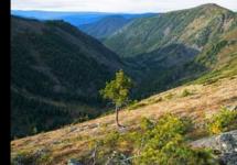
The Yuzhno-Chuyskiy ridge is lower than the Severo-Chuiskiy ridge, the average height here is 3000-3500 m, the highest point is Mount Irbistu (3967 m). On the slopes of the South Chuisky ridge, unlike the Severo-Chuisky, there is practically no forest - only meadows and thickets of dwarf birch. Thanks to this, many peaks offer a beautiful view of 30-50 kilometers around, picturesque panoramas of the harsh Chuya steppe, the Katunsky and Severo-Chuisky ridges.
Climate
The South Chuisky ridge is located in close proximity to the arid semi-deserts of Mongolia, which affects the climatic features in this area. There is much less precipitation on its slopes than on the Severo-Chuisky or Katunsky ridges, however, very large glaciers also flow down from the slopes of the South Chuisky ridge.
Glaciers
The South Chuisky Range is the second largest glaciation in Altai. The 243 glaciers located on it have a total area of \u200b\u200b222.8 km². The central place is occupied by the Bolshoi Taldurinsky glacier, which is more than 8 km long and its area is 34.9 km², and the Sofiysky glacier is 10 km long and 24 km² in area.
Rivers
Large tributaries of the Chuya originate from the ridge - the rivers Chagan, Taldura, Tarkhata, Irbistu. On the other side of the ridge, numerous tributaries of the Dzhazator (Zhasater) River originate.
Lakes
There are many lakes on the Yuzhno-Chuisky ridge, and in beauty they are not inferior to the lakes of the Severo-Chuisky and Katunsky ranges. The most picturesque lakes are Akkol and Karakol in the Akkol river valley. Akkol is translated from Altai as "white lake". Indeed, the water in it is light, milky. Karakol is, on the contrary, a "black lake", and this is also true - the water in Karakol seems dark. It is noteworthy that these opposite lakes are located only two kilometers from each other. On the shores of Lake Akkol, tourists often set up a base camp, from where they make walks to the Sofia glacier or make mountaineering ascents to the surrounding peaks.
Tourism
Tourists began to visit this area much later than the Severo-Chuisky or Katunsky ridges. This is due to the transport remoteness of the area, and to the fact that in Soviet times these places were considered a border area, the passage through which was carried out strictly by passes.
The South Chuisky ridge is located in the south of Altai, it is bounded in the north by the rivers Karagem, Ioldo-Aira, Taldura, in the south by the Dzhazator river. In the east, its border conditionally runs along the Tarkhata River, to which the Sailugem ridge adjoins, and in the west it is bounded by the Argut River and the Katunsky ridge. The South Chuya ridge stretches in an almost meridional direction for 90 km. Its western part is slightly north of the eastern one.
The South Chuisky ridge is one of the three Altai proteins, two other proteins are the North Chuisky ridge and the Katunsky. Squirrels are the old name for white mountain ranges (that is, ridges with glaciers and permanent snow). It is they who largely form the microclimate in the area of \u200b\u200bthe South Chuisky ridge. Moist air masses enter Altai from the west, the higher Katunsky and Severo-Chuisky ridges hold them back, and therefore less precipitation falls on the Yuzhno-Chuisky. However, there are enough of them to form large glaciers. All major glaciation covers the northern slopes of the South Chuisky ridge. The largest glaciers are Taldurinsky and Sofiysky. Vasily Sapozhnikov, a Russian scientist, botanist and geographer, was the first to discover and describe them at the end of the 19th century. The Taldurinsky glacier, for a long time, was generally considered the largest glacier in the Russian Altai, but due to global warming, it divided and, as a result, lost its primacy.
The relief character of the South Chuisky ridge is alpine, with many peaked alpine peaks of outstanding beauty. The main peaks of the South Chuisky ridge from east to west:
Irbistu (3967 m) - the highest point, Tymoin (3707 m) and Testoy (3868 m) in the same mountain range; detached - Janiktu (3922 m), next to which there are peaks Janiktu (3716 m) and Ilyas (3746 m) in the main ridge; further Chuisky peak (3777 m); in the upper reaches of the Sophia glacier: Brother (3885 m), Ksenia (about 3500 m) and Sestra (3750 m); in the upper reaches of the Taldurinsky glacier: Olga Vostochnaya (3735) and Olga Zapadnaya (3723), Iiktu (3941 m) - perhaps the most beautiful peak in the entire ridge; to the north of Iiktu - Metallurg peak (3933m).
You can read about the history of the first ascents to the peaks of the South Chuisky ridge in the article.
Glaciers give rise to many rivers flowing down from the South Chuya ridge. The main ones are: Elangash, Karaoyuk, Akkol, Taldura, Oshtuayry, Meshtuayry, Bara, Tyun, Uzurgu, Tangyt, Tara. Also in the area of \u200b\u200bthe South Chuisky ridge there are large lakes: Dzhankul (Dzhankel), Atkul (Atkol), Karakul (Karakel), Akkul (Akkol), and many smaller ones.
Throughout the entire length of the South Chuisky ridge, there is only one pass through which you can get from the southern part of the ridge to the northern one on horseback - this is the Azu pass (2911 m). It has long been used by the local population, as evidenced by both the name (Azhu - a pass with a road) and an impressive o at the pass itself.
The fauna of the South Chuya ridge is diverse and is determined by different types of landscape. The southern slopes are drier, with less water and forest than the northern ones. At high altitudes, in alpine meadows, the Siberian ibex is widespread, and in some places there is still a snow leopard - the irbis. On the northern slopes of the ridge, especially in the Karagem valley, red deer is often found, wolf and bear are everywhere. The detachment of rodents is also widely represented, the main representatives of which are: ground squirrel, marmot and senostavka. Among birds of prey, the golden eagle, raven, and steppe eagle are widespread.
The tourist development of the Yuzhno-Chuisky ridge is lower than that of the Severo-Chuisky and Katunsky because of the longer and less convenient access roads, and also due to the fact that in Soviet times (and even now) the entire southern slope was included in the border zone , and to get there, you need to get a pass. The most popular were two compact regions: the vicinity of the Iiktu peak with the Taldurin glacier and the Taldura river, and the vicinity of the Brat peak with the Sofia glacier, the Akkol river, and Lake Akkul. These two regions are separated by a meridional ridge - the Taldurinskaya fence, through which there are several passes connecting them. Usually, these areas were visited by sports groups, which combined in their route the Yuzhno-Chuisky ridge with the Severo-Chuisky, or with the Katunsky. The vicinity of the Janiiktu and Irbistu peaks were less frequently visited, with the exception of the Azhu pass, which is popular with ordinary walking groups. The westernmost part of the ridge in the vicinity of the Bara River, and the eastern one in the region of the Sebysty River, practically did not see tourists.
There is practically no commercial tourism on the Yuzhno-Chuiskiy ridge. In our opinion, it is not deserved, since this is one of the most beautiful and unlike anything else in Altai. We are trying to fill this gap and offer our routes:
In our photo gallery see