Last time we "closed the February window" on Chatyr-Dag, and this time we went to Bakla.
It is easy to get from Simferopol to the cave town of Bakla - the settlement is located only 17 km from the city.
The starting point is the Western bus station on Sevastopolskaya street.
For independent travelers I give the bus schedule. Simferopol - Scientific, take a ticket to the village of Skalistoye. 
We arrived at the bus station at 13 o'clock, and in order not to wait 50 minutes for the bus we went to Bakhchisarai. The ticket costs 18 rubles.
You need to leave at the turn to Nauchny. In this village there is the Crimean Astrophysical Observatory. But today our
target - Bakla cave settlement.

You can go in different ways, we went the shortest, through the quarry.
The store has a "lucky" crossbar. You can tie the horse and fasten the bike.

From the store you have to walk 400 meters and turn left on the asphalt. The quarry can be seen from the road, it is difficult to make a mistake.
Once a stone was mined in this bowl, but having gone deeper into the thickness of the mountain, we reached the aquifer and flooded the quarry over the weekend.
Locals say that the bottom is full of equipment that they decided not to get out of the water.

The quarry stepped higher up the slope, and the stone is still being mined.

Now on Google maps this place is called the Martian Lake - because of the unusual color of the water.
Now there is ice on the lake. From under the water you can see blocks of limestone, cut by water.


There is a forest above the quarry, along the forest there is a road across the field. We walk 300 meters across the field, then the road dives into the pine trees.
The path lies uphill, along the gentle Northern slope of the Second (Inner) ridge crimean mountains.
At a calm pace, in 20 minutes we passed the forest and came to the cliff.
Photo in the background itself beautiful mountain Crimea. Handsome Chatyr-Dag turns white on the horizon.

Rodents dug their own trenches under the snow. The whole mountain is in such mouse "trenches".

When the forest is clothed in foliage, the view will be excellent. But we like Crimea at any time of the year.

Motors can be heard below - five ATVs moving towards Buckle.

We go down to the hill fort, examine the grain pits covered with ice.


My Valeria loves to be photographed in any beautiful place.

We go down under the edge of the cliff. There is rocky beauty here.

Lace breaks attract our eyes, walk, admire.
Once in these places we held a photo meeting. Photographers and bloggers came from Sevastopol and Simferopol.
Here in this grotto with a column, photographer Aleksey Patsyuk took a space frame:


During the day, you can't imagine how beautiful it can be here at night.
The first spring insects. Soldier bug, or red-winged wingless warmed up in the sun and made a bunch of mala.

In this place I really want to stay longer. And so we did. We sat down and began to drink tea!

The wind sounded in the stone laces, continuing its many years of work - weathering.

Galvza was watching us from above. Buckla's blue eyes.

On the horizon peeps out an "iron" - a rock on which the neighboring cave city Tepe-Kermen.
In the valley, a small crushed stone quarry rumbles and glows. We move under the rocks in his direction.

On the way we see a miniature waterfall. Now there is water, in summer, alas, the source will dry up.

The path under the rocks is narrow, overgrown with thorny trees, wild rose and blackthorn.
We seep with difficulty, take care of our face and clothes.
In one place we notice a passage to the edge of the rocks. Depressions are made in the stone - steps. With mountaineering skills you can
climb, but our goal is a grotto with petroglyphs.

The rock resembles the Fourth grotto of Kachi-Kalion. Reduced copy. The rocks on the starboard side of the Kachinsky canyon are about 60-100 m higher.

And here is what we were looking for. Petroglyphs are carved images on a stone base. They can have very different themes - ritual, memorial, symbolic with all possible intersections.
There are about 400 petroglyphs in the grotto near Bakla! Moreover, they were opened relatively recently - in 2000.
It's not so easy to get into this grotto, many people prefer to descend on ropes from above.
I climbed the cliff from below, however, if you are unsure of your climbing ability, I would not recommend repeating this path.

In the search on the very first site, complete information is given (Golovina14.narod.ru): On a brown crust, outlines of clearly not natural figures appear. As soon as the eye catches on one, the others immediately begin to distinguish. It turns out that there are a lot of them here.
Archaeologists have counted more than 400 images carved and scratched into stone. total area the accumulation of drawings is 5.3 m2. Previously, it was larger - a significant part was destroyed by weathering. The thin desert tan crust on which they are applied is easily vulnerable and fragile.
Usually the ancestors decorated the walls of caves and grottoes with their creativity. Here, the drawings are on the inclined bottom, which is rather atypical. Cruciform figures predominate among them, not unreasonably identified with the Christian cult. But there are also circles, there are only 20 of them, while there are more than 300 crosses. The circle is an ancient pagan symbol - a solar sign, an image of the sun. The neighborhood of symbols so alien to each other seems strange and there can be only one explanation for it - the ancient pagan sanctuary, located in the grotto, was later "re-profiled" into a Christian one.
The choice of such an inconvenient place in need of improvement is puzzling. There are plenty of large and spacious grottoes available around. Why would you risk your life to break into this one? And in order to avoid risk, it is necessary to attach some kind of auxiliary structures. And so it was done. Along the floor of the cave, there are rows of depressions, clearly intended for the installation of frame-and-pillar structures. Scientists suggest that there was a wooden flooring in the grottoes, possibly even two-tier ones. Most likely there was also a staircase.
The time of the existence of the sanctuary is determined approximately. To date the images, scientists compare them with those already known, the age of which is beyond doubt. Crosses from the grotto have a shape characteristic of the 6-7th century. The upper dating is rather strictly limited to the end of the 7th century, since in 692 the Trull Ecumenical Council forbade placing the symbols of Christianity where it is possible to trample them with your feet, that is, on the floor.
That is, in fact, all that science can say. And so far, there is a lot of unclear: what kind of people created the drawings and for what purpose, whether they have something to do with the Baklinsky settlement, where the first buildings have already begun to appear. As always, there are more questions than answers.

This is what he is, Crimea. Full of mysteries and secrets, which will be enough for many more generations of researchers.

Under the rocks, at the very bottom of the ravine, there is a dirt road, along which in 30-40 minutes we go out onto the asphalt near the southern outskirts
village Skalistoe. The sun hides behind a ridge, and we get on the bus and return to Simferopol.

This walking journey at an absolutely calm pace took 4.5 hours.
Night photos can be viewed in LJ Victoria Stupina.
On which the citadel of the same name stretched along the cliff. It was 60 meters wide and about 200 meters long.
The cave city of Bakla, translated from Crimean Tatar means beans, this name was apparently given because of its elongated shape.
The approximate date of the emergence of this fortified settlement on the top of Bakly is the second half of the third century. And only a couple of centuries later, at the turn of the fifth and sixth centuries, the first line of defense was built here, and they began to strengthen it only in the eighth-ninth centuries.
The wall was erected on the southern side of the mountain, in its most vulnerable part, since from here it was easy to get into the city along a rather gentle slope.
From the third to the fourth century, the fortification and the village were one whole, the southern part of the plateau, which was later fortified, was occupied by outbuildings that were part of the wine complex, and in the sixth century this place was occupied by the castle.
This defensive structure was built from large limestone blocks on a mortar of the same material.
Under western part of the fortress, in a twenty-meter cliff, there were battle caves, in which there were either stairs carved into the rock, or holes-hatches made.
The caves were located in such a way that all the surrounding lands were perfectly visible, so from here they not only carried out frontal shelling from bows and sling when the enemy was on the way, but also carried out patrols in peacetime.
Basically, all the premises for military and economic purposes were cut down in the limestones of the chalk cornice or in marls.
The castle was surrounded by a moat, which further increased its protection, but the villages and settlement adjacent to the fortification were not protected by walls, which is not surprising for the feudal complexes of the Middle Ages.
In the place where the village was located, you can often find fragments of large clay pithos, and in its eastern part a pottery kiln was discovered, from which, of course, there is little left in our time.
At the moment, on the territory of Buckle there are traces of closely adjacent two-story houses and narrow streets, a small temple of the nineteenth century, built into a complex of residential buildings. You can find burial grounds carved into the rocks, grape presses and grain pits, water troughs, the ruins of a tower and a fortress wall, a church built in a cave, about a hundred artificially created cave rooms, which are located in two tiers. Basically, all the cave premises were of a defensive or economic nature, the inhabitants of the city settled in above-ground buildings, from which to our time there was no stone left over.
The citadel fell, like many fortifications in the year one thousand two hundred and ninety-nine, with the attack on the Crimea by the hordes of Temnik Nogai.
For the first time Bakla became interested in 1929 employees of the Crimean local history museum, and in 1961 the work was carried out by the State Historical Museum. In the post-Soviet period, the so-called "black archaeologists" laid eyes on Bakla and plundered most of the historical heritage.
Photo
Reading time: 4 minutes
The fertile, hospitable Crimea pleases its guests not only with the gentle sea, bright sun and delicious grapes. The peninsula keeps many historical mysteries and secrets. Such a mystery is the cave city of Bakla. The most accessible and least known among all Crimean ancient settlements. The place is great for excursions with children and. You can see the camp of the Neanderthals, visit the ruins of ancient temples and swim in the lake with fish.
Backla Cave City - Loremaster
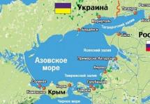
It is located near the village of Skalistoye, Bakhchisarai district, on the Tav-Bodrak massif. The height of the mountain is 300m. This is the northernmost cave city.
There are two variants of the origin of the name. The first one says: the name translated from the Turkic means "beans". Carved into the rocks, the caves are shaped like the seeds of legumes.
The second one says: the name comes from the word "baklak" - a vessel for water. The inhabitants of the village used special stone pits for storing grain, shaped like jugs.
Scientists discovered the site in 1929. Since then, several important archaeological discoveries have been made. Historians have found out: people lived here in the Paleolithic era. However, only in the III-IV centuries. AD a large-scale settlement appeared.
Bakla had no military significance. The caves are located so that it is practically impossible to defend in the event of an attack. There is nothing that resembles battle fortifications. It was a city of farmers. Archaeologists assume that Alans, Goths or Sarmatians lived there.
The inhabitants were engaged in agriculture, animal husbandry and winemaking. Grain pits carved into the rock are located throughout the territory. Until now, it remains a mystery how residents managed to create a depression with a narrow neck and a volumetric chamber inside. Granaries are located in large numbers throughout the area of \u200b\u200bthe archaeological site. Tourists should be careful: the holes can be overlooked in the grass.
Since the V century. Christian churches began to appear in the valley. The settlement existed until the end of the 13th century. Died after the raid of the Golden Horde. 
Attractions Bakla
On the territory of the plateau, you can find artificially carved caves, the remains of the masonry of small buildings, grape pressures and cave temples.
The ancient city can surprise guests with its own natural sphinx. This is a rock above the western cliff. Its height is 40 meters. Crimeans call the Sphinx "lonely watchman".
"Cheese Rocks" are the result of cellular weathering. Their surface resembles cheese or a sponge. Such natural miracle there is also on Buckle.
On the southeastern side of the rock mass there is another attraction - the Shaitan-Koba grotto. The place is interesting for two reasons: 
- in 1929. scientists have discovered there a site of primitive people of the Middle Paleolithic era. Among the finds were flint tools and an ancient hearth;
- the grotto owes its name (from the Crimean Tatar - "Devil's Cave") to the frightening, mysterious atmosphere enveloping under its arches.
What to see nearby

You can visit the cave city. Or you can walk around. There are plenty of attractions there.
Even on the approach to Buckle, a view of the amazing lake opens. Official name the reservoir does not. Locals call it Martian because of its unusual landscape. The purest water of the color of copper sulphate splashes in the banks of snow-white limestone. The history of the appearance of the lake is remarkable. In fact, this is a flooded quarry for the extraction of stone.
One evening, the workers turned off the pumps that pump water out of the mined formations and went home. When they returned after the weekend, they saw a 40m deep lake instead of a quarry. Since then, development at this site has ceased, and the peninsula has received another pearl in a considerable collection of attractions. The water is very clear and clean, it warms up by May. And a special entertainment - small fish swimming near the swimmers.
The stone that is mined in the quarry is also unique. Alma limestone is so good for construction that in ancient times it was transported even in Ancient Rome.
The Glubokiy Yar ravine is located 8 km southwest of Skalisty. There, travelers will find the "Bakhchisarai Stonehenge" - several menhirs. The place will appeal to people who are fond of esotericism, or who want to join the mystical energy.
Space lovers will love the excursion to the village. Scientific. It takes place in the evening. You need to sign up in advance. The staff will not only tell you about the planets and stars, but also let you look at them through a telescope. Before the excursion, you can take a walk in the forest nearby. The air is amazingly clean and fragrant. In the autumn, you will be able to pick up mushrooms.
In the middle of the way between Nauchnoye and Skalisty there is a cluster of artificial lakes. They have small, retro-style wooden docks. A good place for atmospheric photos.
How to get to Buckla
The path can be done on personal car or at public transport... Car owners on the Simferopol-Bakhchisarai highway should turn to the Nauchnyi signboard and drive without turning off the main asphalt road. After 2.5 km, the Martian Lake will appear before the eyes of travelers. Before him turn left, onto the dirt road. It is better to leave the car by the reservoir. It is possible to drive upstairs by car. However, this is fraught with its technical condition.
Those traveling on their own will have to start from the Zapadnaya bus station in Simferopol. Buses go to the village. Scientific. They run every hour from 6.00 to 18:55. You need to get off at the Skalistoye stop. And from there, along the main road, walk to the lake.
Bypassing the flooded quarry, travelers get to the barrier. A simple ascent along a well-trodden path begins from it. The path goes up the slope through the forest. Having overcome it, tourists get to the very beginning of the plateau. To see the sights, you need to go left.
For those wishing to continue exploring the next day, there are several options for overnight:
- private rented accommodation in Skalisty;
- hotel on the territory of the village. Scientific;
- mini-hotel in the village of Novo-Pavlovka;
- tourist center in Trudolyubovka.
Bakla is a place worth visiting. It is suitable for traveling with children. There are few people and a lot of history. You can touch the antiquity and admire the picturesque views of the Inner ridge of the Crimean Mountains. Thanks to its accessibility and beauty, the cave city will leave many pleasant memories for tourists.
Bakla is the most northern of all cave towns in Crimea. It is located on the rocks near the village of Skalistoye, Bakhchisarai region, in the place where the Bodrak river flows into the Alma. Bakla attracts visitors with a variety of rocks. Future geologists of Russian universities undergo practical training on the territory of the ancient settlement.
The original name - Bakla, the cave city received from the Turkic name of the water vessel “Baklak”, which has a narrow neck. The main feature of the settlement is the presence on its territory of many grain pits with just such a shape. According to one version, a strategic grain reserve was stored in the city, calculated for the population of the surrounding valleys.
The cave city is located on a spacious plateau, which is bounded by 15-meter rocks from the south and east, and surrounded by limestone ridges from the north and west. The surrounding landscape is replete with bizarre forms of weathered limestone. On the steep slopes of Cuesta you can find shells of fossil oysters, sea \u200b\u200burchins and other inhabitants of the sea who lived here 50 million years ago. The 40-meter sphinx is quite remarkable. On the slope of the ridge, there are thousands of natural depressions - cells, which are examples of cellular weathering of rocks.
According to the researchers, a small settlement appeared on the plateau around the 4th century. Its total area was 20 hectares.
In the VI century, thanks to the order of the Byzantine administration of Taurica, part of the settlement was surrounded by a defensive wall, thus turning into a small fortification. At the same time, a castle was erected on the southeastern ledge of the Baklinsky plateau - the residence of the ruler of the local lands.
In the 8th century, the Khazars captured the settlement, who ruled this territory for about a century.
In the XIII century, Bakla began to flourish. At this time, several Christian churches operated in the city, agriculture, winemaking, and pottery were developing. At the end of the XIII - beginning of the XIV century, the city was devastated by the troops of the Golden Horde Temnik Nogai. After that, life in the settlement gradually faded away.
The town was located in an accessible place, not far from the villages and therefore was periodically exposed to enemy raids. As a result, almost all buildings in it were dismantled and taken away by the neighboring residents.
Today, on the territory of Bakla, you can see the ruins of closely standing two-story houses and narrow streets. The remains of a small temple of the 9th century, built into a complex of residential premises, graves carved into the rocks, grain pits, the remains of grape pressures, masonry walls, the remains of a fortress wall and tower, a trough for collecting water, steps, a cave church have survived. Affects a large number artificial cavescut in limestone and arranged in two tiers. About a hundred rock rooms were used for economic and defensive purposes. The population lived in aboveground buildings, which, unfortunately, have not survived.
On the western outskirts of Bakla you can find traces of a church and crypts carved into the rock. Most likely it was a monastery. This is evidenced by semicircular cells with low corridors, in the walls of which niches are hollowed out for lamps and icon lamps. Nearby there is a grotto decorated with wall paintings. They depict figures of holy martyrs, crosses, silhouettes of a temple, ships and fish. Another small cave church is located above the church complex in a rock ledge.
Not far from the temple, near the river Kuba, in 1970 a necropolis of the 5th-9th centuries was opened. The excavations have yielded a wealth of valuable information and precious finds. In total, more than 800 crypts were investigated, in which people were buried from the 4th to the 11th century AD. e.
You can get acquainted with the finds in the Bakhchisarai Museum. The exhibition features a Byzantine belt buckle and bracelet, two brooches, rings, crosses, ceramic and glass dishes and much more.
The history of Crimea keeps many secrets and mysteries. Scientists are still studying it, finding more and more confirmation of the events of ancient times. Bakla is one of the complexes located on the peninsula that arouses the greatest interest of researchers.
Where is the city?
The mysterious settlement is located near the village of Skalistoye, in Bakhchisarai. There is also the Martian lake, which amazes with its truly unearthly beauty.
Backla cave city: history
This historical monument is the northernmost cave town of Crimea - behind it is only the steppe. This location played a special role in his fate. The city was founded at the end of the 3rd century, in the 8th-9th centuries its first line of defense was strengthened. By the time the building was created, it was a single whole with the village, on the southern side of which there were various household buildings, including a wine-making complex.

In the 6th century, a castle was erected in its place. All of its defenses were made of massive limestone blocks. Under the western section of the citadel, under a twenty-meter cliff, there were battle caves. In some of them there were hatches, in others - stairs carved into the rock. Here slingers and archers served and fired on the flanks.
The castle was protected by a deep moat. The rural settlement adjoining the structure and the settlement were not protected by walls, which is typical of the feudal complexes of that time. The name of the settlement originates from the Turkic language. The word Baklak means a vessel for water. It should be noted that main feature of this city - grain pits in the form of bowls with a narrow neck.
The cave city of Bakla (Crimea) was first studied by the staff of the local history museum of the peninsula in 1929. In 1961, scientists joined this work Historical Museum Moscow. In the post-Soviet period, the cave city of Bakla, as well as the surrounding necropolises, were plundered by "black archaeologists".
Population
The inhabitants of the ancient city were Sarmatian-Alans and Goths, who were engaged in animal husbandry, agriculture and wine making. This version of scientists is confirmed by more than two hundred grain pits that have survived to this day.
According to a number of researchers, the Byzantines used the cave city of Bakla for some time - they converted local residents here to Christianity and deployed their troops. Numerous ones made it possible to assert that when the city was threatened with mortal danger, the inhabitants left Bakla and took refuge outside the walls of another city - Chufut-Kale, which was nearby.

The cave city of Bakla, the photo of which we have posted in this article, existed until the end of the 13th century. By this time, the invasion of the Horde troops on the peninsula, led by Khan Nogai, belongs. This invasion was the last battle with the nomads, as a result of which the cave city fell. Buckle just barely reached the millennium since its inception. For several centuries this center of culture and religious enlightenment of antiquity existed, but since the XIV century, people no longer lived here.
Description of the settlement
The cave city of Bakla is clearly visible from afar - from the valley located at the foot of the settlement. Climbing closer to the plateau along the slope to the grottoes themselves, one can immediately see numerous holes in the soft limestone rock. In shape, they resemble ancient Greek pithos - huge vessels for storing wine. But most often grain was stored in these.
Everything archaeological finds confirm that for many centuries cereals, mainly wheat, were grown here. There is a version that part of the crop was imported from more northern regions. Thus, the city of Bakla was used as a commercial junction between the coast and the steppe.

Water
IN ancient city there have always been difficulties with water. The struggle for the preservation of precious moisture occupied a significant place in the life of the villagers. For this, various devices were created, which can still be seen on the rocks today.
An active spring has survived to this day in the upper part of the plateau, which usually dries up by mid-summer. Traces on the stones indicate that in ancient times it was more full-flowing, and was one of the sources of water for local residents. In some areas, the so-called herringbone is visible - a special depression in the stone, which made it possible to collect rainwater.
Religious buildings
Undoubtedly, Bakla was an important early Christian religious center. This is evidenced by the foundations of several temple structures. This gave researchers grounds to assert that during the years of persecution of Christianity in Byzantium, many supporters of the faith fled here from persecution, where the mores were somewhat milder. This explains the presence of several churches that were built in the city.

There is an opinion that the cave city of Bakla was more actively used by the Byzantines as an outpost of Christianity, and not as a military stronghold. On the western outskirts of the city you can see the remains of a church of quite impressive size, and crypts in the form of quadrangles, which are carved into the rock. Apparently, it was a monastery. Semicircular cells with low and narrow corridors have been carved into the rocks nearby. Niches for lamps and lamps are hollowed out in the walls.
There is also a grotto on the walls of which there are drawings: crosses, figures of holy martyrs, silhouettes of ships, fish and temples. Above this church complex, there is a very small church, located in a rock ledge. Not far from it, slightly downstream of the small river Kuba, a necropolis was discovered in 1970 (V - IX centuries). During the excavations, scientists examined over 800 structures, usually crypts. Experts attribute their creation to the IV-XI centuries A.D. e. In the Bakhchisarai Museum, you can see valuable artifacts. Shown here are: a Byzantine bracelet and belt buckle, brooches fastened with a chain on the chest, crosses, rings, glass and ceramic dishes.

Opposite Bakla, in the valley, the remains of three more temples were discovered. The oldest of them was built in the 8th - 9th centuries. In the X - XI centuries. a temple appeared on this earth, cruciform in cross-section. Only fragments of a frieze and fragments of an arched portal of the Byzantine style have survived to this day.
Bakla cave city (Crimea): how to get there?
From Simferopol to the village of Skalisty, a regular bus runs between the Zapadnaya and Simferopol-Nauchny stations. It is located eighteen kilometers away. Travel time is twenty minutes.
Today many tourists are interested in Bakla (cave city). How to get here by car is of interest to many motorists. You should go to the highway "Sevastopol-Simferopol" and drive until the turn with the sign "Scientific", the next turn to the village of Skalistoye.
You can use the electric train. From Simferopol he will take you to the Pochtovaya station. From here you will have to walk two kilometers on foot to Novopavlovka, and take the bus to the Nauchny station.
Where to stay?
Since the closest locality from the cave city - the village of Skalistoe, it is best to stay here. True, there are no hotels or camp sites, but locals will gladly rent you a room. The cost of living is 500-600 rubles per day.
For cyclists there is a tourist center in Trudolyubovka, as well as the Skif hotel in Novopavlovka. Here the room rate varies from 1100 to 1800 rubles.