Main attractions Mountain Altai are represented by natural rare objects. We will try to give a small overview of attractive places to visit.
Museums and man-made objects
Roerich House Museum. Located in the village of Verkhniy Uimon. The main exhibition is dedicated to the work of the famous artist, scientist and thinker. In addition, you can watch themed films, visit the exhibition pavilion and the bookstore. Temporary exhibitions are periodically held here.
Monument to V. Shukshin. The bronze 8-meter monument stands in the historical homeland of the famous actor. In a simple posture of a person sitting down to rest and think, he seems to be on the top of a mountain. The monument opens to the view gradually and very interestingly. A popular location for taking photos and videos.
Monument "Altai - the heart of Eurasia"... One of the most characteristic objects of Gorno-Altaysk is located on the Chuisky tract. The world tree, the North Star, the symbolic image of a yurt - a dome and a hearth - all of this carries universal world symbolism. The object is located in a place that has long been considered the center of the World. It also contains messages to descendants in several languages.
Tourists are attracted not by the station itself, but by the water amusement park, which is organized here in summer. In addition, you can visit unusual springs with "living" and "dead" water. If you didn't have time to buy souvenirs, here you can find a large number of them, from popular pine nuts and natural honey to exclusive minting, which will be done right in front of you.
Botanical Garden... The sight of Kamlak literally represents the pages of the "Red Book" - there are so many rare and unique plants here.
Republican Museum of Local Lore... It is located in Gorno-Altaysk and is the oldest museum in the region. Even in its form, it organically fits into the surrounding space, resembling one of the ancient burial mounds. The museum contains several tens of thousands of exhibits, including one of the main historical values \u200b\u200bof these places - the mummy of the "Altai princess". There is a souvenir shop at the museum. You can dine at a local cafe.
Reserve "Katunsky"... The place near the village of Ust-Koksa strikes with its beauty wildlife... It is located in the highest mountainous region of Altai and includes the main attraction - Mount Belukha, the highest point of all Siberia. Here you can find interesting programs for yourself in the ethnomuseum, ecological camp. Interesting for both children and adults.
It is famous not only for its unique beauty and special atmosphere. TO miraculous icons people arrive with their requests. Tourists far from the faith simply enjoy the opportunity to walk along the old suspension bridge and admire the scenery. It is worth visiting the Church of St. John the Evangelist.
Natural unique
Lake Aya... It is the oldest body of water in its origin. You can swim here in the middle of summer, as the water temperature reaches 25 degrees. Interesting to visit natural Park on the shore. It is worth visiting the excursion along the Katun River valley and taking a photo near the Devil's Finger Mountain.

Korbu waterfall... It belongs to the largest waterfalls in Lake Teletskoye. It is very popular due to the special effect of water droplets falling from a great height. They create a kind of "wind out of water". The surrounding steep cliffs covered with a mysterious forest are no less attractive. Nearby there are animals listed in the Red Book.
A special place on the Anui River has become a place of pilgrimage not only for archaeologists from all over the world. Since the end of the 20th century, tens of thousands of historically valuable items have been discovered here - evidence of an ancient civilization. The place is included in the list of UNESCO World Heritage Sites.
Chike-Taman pass... It will delight those who prefer interesting climbs and rare natural beauty. The difference in height creates amazing landscapes. Sheer cliffs alternate with valleys. There is an excellent observation area. And nearby there is an ancient shamanic tree - larch. On its branches, visitors tie pieces of white cloth for good luck.
Teletskoye lake... One of the cleanest and deepest reservoirs in the Russian Federation. Exploration of its waters and surroundings is still underway. Lake Teletskoye is surrounded by beautiful mountain ranges. There is a large nature reserve on its shore. There are many tourist centers nearby. A wide variety of excursions and routes are available. You can even go fishing.

The twelve-meter two-stage natural object will make you feel like the heroes of an action adventure. After all, you will have to go to him along the most real suspension bridge in the thicket. You can even swim in the streams of the waterfall. On the way, the guide will tell you an interesting legend about the name and origin of the Altai natural unique.
Kur-Kechu... The ancient tract has become a bright attraction of the Kupchegeni town. Here two rivers merge - Katun and Bolshoi Ilgumen. Mystical place addictive for hours. You can wander for a long time among the old ruins, mounds, remains of religious buildings and rock paintings.
Source Kara-Kebek... It is interesting not only for its healing water with a high content of iron and silicon. Here you can observe unusual animals and birds that live in the wild. The variegated butterflies and the Red Book plants of the surrounding area are also delightful. Access to the key in the vicinity of Ongudai is absolutely free.
Tugaya and Komsomolskaya mountains... If you prefer an active holiday, this is the place for you. Popular climbing trails vary in difficulty. Fantastic views surround the road. Rare species of flora grow here. And the mountains themselves are hundreds of millions of years old in their origin.
What else to see in Altai
Love stone... Check in at the legendary stone on the banks of the river. Biya - everyone who visits these places considers it a must. The history of the village of Turochaka speaks of 2 lovers, bewitched for admiring each other, and not a beauty - the river. The place is also popular with newlyweds and everyone who only dreams of finding love.
The place is worth visiting for all history buffs. The ancient rock paintings found here are very well preserved and accessible for inspection. Petroglyphs will turn your understanding of history and make you think about the many secrets of the universe.
Mineral spring in the village of Manzherok... It is known for its medicinal properties. Its waters contain a large amount of silver. Water can be drawn directly from the key. It is especially recommended for those suffering from diseases of the stomach and kidneys.
Build your own unique route through the numerous sights of Altai!
There is no need to specifically look for sights in Altai, they are everywhere. You can pick up those that will be of interest to you. Lovers active rest in nature they will be able to see mountain ranges and gorges, ice lakes, waterfalls, caves. Those who are more interested in studying history and culture will be interested in seeing these Altai riches. About a dozen museums are open in the cities and remote villages of Altai. Museum of Natural History, Museum of Stone - their expositions are composed of local archaeological and geological finds. The museums-estates of Roerich, Choros-Gurkin, the Golovan family preserve the houses and everyday life of famous people associated with history Altai Territory.
Altai sights can be divided into natural and cultural. It should be borne in mind that each season in the region offers special opportunities for getting to know it.
Some of the sights of Altai mountains can be seen, having reached them on foot, others are most interesting to explore in a horse trek, still others are available only to auto travelers, and the fourth to climbers.
Tourism in Altai is a real chance not only to discover something new, but also to choose the desired level of extreme travel for yourself.
Experienced climbers and young pathfinders, lovers and retirees, extreme climbers and "seals" - in Altai everyone decides where to go and what sights to see.
Natural attractions
Not every region can offer tourists several natural monuments protected by UNESCO at once. Altai - maybe.
Golden Mountains of Altai
This two nature reserve - Altai and Katunsky, as well as the Ukok plateau. It is from here that tourists bring most of the photos of the sights of the Altai Mountains. 16,000 kilometers united several dozen objects of interest for study. Among them are Belukha Mountain, Teletskoye Lake, Korbu and Kishte waterfalls.
Rivers
Several large rivers flowing in the Altai Territory are suitable for water travel.

The Katun is the "main" river of Altai. Stormy and rumbling in the upper reaches, wide and calm in the lower reaches. 700 kilometers of its channel, the groups of rapids on it are excellent for rafting.
Biya is the second largest "water road" in the region, also actively used for rafting.
There are several more wide tributaries of the Katun, the rest of the rivers are mountainous, rough and cold.
Lakes
Altai lakes are mountain ice hollows and plain water bodies that are quite comfortable for recreation. Most, of course, are deep and cold, but with excellent bite.

Lake Teletskoye is a kind of flagship of ecological tourism in the region. There are two dozen infrastructure facilities on the coast; there are several more natural monuments nearby.
Karakol lakes - a chain of 7 lakes descending from the mountains one after another. Each is located at its own height and differs from its neighbors chemical composition water.
Kucherlinskoe is a glacial lake, in the depths of which grayling feels great, and snow leopards come to the watering hole.
Aya is one of the few reservoirs in Altai, where in the warm season you can swim in well-heated water (temperature 20 degrees and above).
Waterfalls
There are really a lot of them in Altai, "the land of mountains and rivers". Only on the Katun, they counted almost 7000! Korbu, Bolshoy Chulchinsky, Kamyshlinsky are the most popular, they go to them most often.

Caves
About two dozen caves of the Altai Mountains are considered interesting for tourists.

Altai - the largest in the region, has not been fully explored.
Denisov - the preserved housing of the Neanderthals. Valuable historical objects were discovered here, now kept in museums.
The museum is the most visited, inside there are several halls with classic stalactites and stalagmites.
Some of the caves are open to the public, some of them are visited only by amateur speleologists.
What is the best season for a trip
The season in Altai cannot be ignored. One and the same season is “high” for some attractions, “low” for others.
Spring
The main thing that is worth seeing in Altai in spring is the maralnik bloom. A good option for those who enviously follow the reports from the spring Japan, "drowned" in sakura. Altai also “bathes” every year in dense thickets of blossoming wild rosemary. Enthusiastic epithets will not help here, it must be seen.

At this time, waterfalls and mountain lakes wake up, meadows of flowers and snow are nearby, the sun and colors come to Altai.
Summer
What exactly to visit in Altai in the summer is up to you. This time of year is perhaps the best time for long hikes. In summer, tourists will be able not only to warm up well, but also to afford a full beach vacation... You need to choose what to see in Altai in summer by car in advance, a properly planned route will allow you to cover the maximum of interesting things.

Fall
The weather in September and October allows you to get to the same attractions as in summer, but with cooler temperatures and fewer tourists. Autumn in Altai is good for long walks, especially if you get up early. Forests and mountain slopes become brighter and more elegant. It's still warm, but not hot anymore - active tourists will appreciate this time of the year most of all.

Winter
In Altai in winter there is a chance to see the non-freezing Geyser Lake or the Shirlak waterfall. Other ice-covered waterfalls are an unusual sight too.

Altai sights do not lose in winter, this is especially true in relation to the mountains. Winter is their time. And it is great for combining excursions with active sports.
Altai cultural attractions
Altai nature deserves a separate story and a separate journey, but there are also many valuable objects in the "cultural field" in the region. There are more than 1000 of them, about a hundred of them are of federal significance. For example, Buddhist stupas and Scythian burial mounds, rare petroglyphs and Pazyryk burial grounds.

The history of the Altai Territory is rich, 1.5 million years of civilization left a memory of themselves. Here is the "cradle" of the Turkic people, the Scythians lived here.
Archaeological sites of the Bronze Age have been preserved on the territory of the region. For example, the Tarkhata megalithic complex, which is an ancient observatory.
Perhaps they will be less interesting to some than humorous art objects, such as Lennon's round glasses or a monument to a clothespin. The main thing is that there is a choice.
A separate area is the monuments of technical progress. Nowhere else can you see so many steam locomotives on pedestals, for example. A visit to the Chemal Hydroelectric Power Station Museum, the main attraction of the region, will give an opportunity to see an attempt to merge natural power and engineering thinking.
Chuisky tract is a monument of road construction, which has acquired modern features, but at the same time has not ceased to be a keeper and witness of ancient history. Today this road is recognized as one of the 10 most beautiful in the world.
Local history museums of the region, museums-estates, monuments and monuments illustrate many significant events that took place in this region.
Nature and history complement each other, ecological and cultural tourism in the region is becoming more diverse and popular.
The Altai Republic is a beautiful and amazing land, where majestic mountains coexist with beautiful lakes. Here you can find traces of ancient civilizations in the caves, and see mysterious drawings on the rocks. Due to the huge number of attractions, as well as the inaccessibility of many places, it is necessary to get acquainted with the Altai Republic in advance and draw up a clear action plan.
General information about the Altai Republic
Altai Republic - subject Russian Federation... The unofficial name is Gorny Altai. It is part of the Siberian Federal District. Occupies an area of \u200b\u200b92 thousand km 2, the population is 218 thousand people. The capital is the city of Gorno-Altaysk.
History
Modern archaeological excavations have shown that the first settlements on the territory of the Altai Republic appeared more than 100 thousand years ago. Further history of these lands:
How to get there
The Altai Republic can be reached in the following ways:
Sights of the Altai Republic
The sights of the Altai Republic are fascinating and varied. Here, extreme lovers conquer mountain peaks, lovers of picturesque landscapes tend to see beautiful lakes, history lovers visit educational museums.
Natural attractions
Most of the natural attractions of the Altai Republic are part of the Altai and Katunsky reserves, which, together with the Ukok plateau, formed a UNESCO World Heritage Site called the Golden Mountains of Altai. The protected area has an area of \u200b\u200bmore than 16 thousand km 2.
Aktru glaciers
The Aktru glaciers are one of the most famous natural attractions of the Altai Republic. Located in the gorge of the same name, at an altitude of more than 2 thousand meters. A feature of the local relief is numerous depressions, which contributed to the accumulation of snow and the formation of glaciers. The total area of \u200b\u200bthe Aktru valley is 16 km 2.
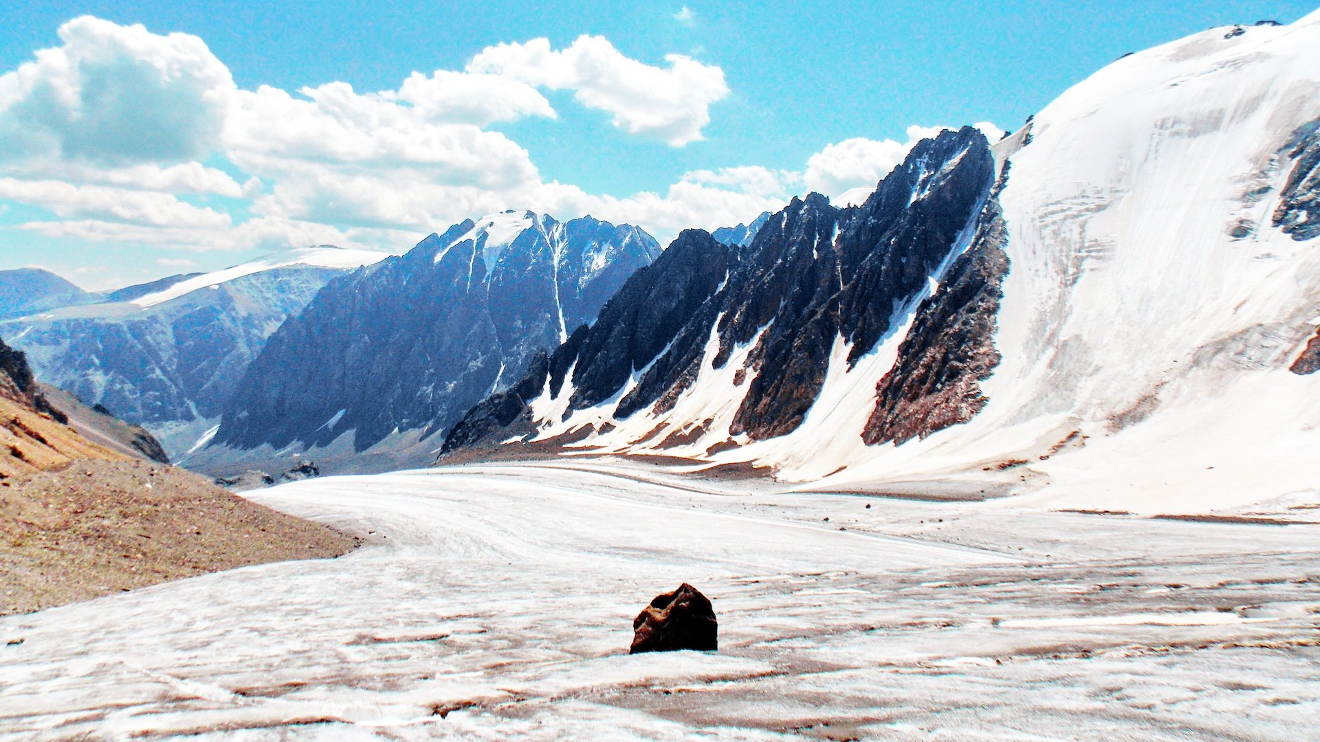 Aktru glaciers cover the vast territory of the Altai Republic, including mountain ranges
 The mountain glacier basin includes 5 glaciers:
Glacier pool decoration - Blue Lake, location on the Big Aktru glacier. The lake got its name from the sky-colored water. In the summer, many tourists come here to admire the beauty of the natural reservoir.
 On the territory of Bolshoi Aktru there is a popular among tourists Blue Lake
 There is an alpine camp in the Aktru valley, which has been functioning since the 40s of the last century and was previously used to train climbers. Today the camp is a tourist base where there is accommodation for every taste: from stationary tents to two-story cottages. The base works all year round.
It is easier to get to the camp site by car along the following route:
Sacred Mount Belukha
It is the highest mountain in the Altai Republic, located in the east of the Katunsky ridge. The absolute height of the mountain is 4409 meters. It has three peaks: Eastern Belukha, Delone peak and Western Belukha. The peaks are always covered with snow, which is why the mountain got this name.
 Belukha is the highest mountain in the Altai Republic
 Altaians consider this mountain sacred. According to an ancient legend, Belukha is the home of the goddess Umai, who symbolizes the feminine principle. Belukha has other names, the most unusual of them is "Uch-Orion". The summits of the sacred mountain are positioned relative to each other in the same way as the three central stars of the constellation Orion. Perhaps the Belukha is really closely connected with space, and the snow-white mountain peak - the personification of spirituality and purity. Many travelers note that the presence of mysticism is felt on the mountain.
 Three peaks of Mount Belukha - exact projections of the central stars of the constellation Orion
 The Belukha slopes are covered with numerous glaciers, thanks to which the Katun, Kucherla and Akkem rivers were formed. These rivers are fleeting and often create extraordinary beauty waterfalls. Thus, the right tributary of the Katun formed the beautiful Rassypnaya waterfall.
 The right tributary of the Katun River created a beautiful Rasypnaya waterfall
 Siberian spruce, fir, birch and mountain ash grow on the mountain. Shrubs are dominated by honeysuckle and lingonberry. Shrews, voles, mountain goats live among the animals. The order of birds is represented by grouse, alpine jackdaws, choughs. There are also rare species of birds listed in the Red Book: lentils and golden eagles.
 Lentils live on Belukha - a bird listed in the Red Book
 Many people strive to “conquer” Belukha and climb to the top, but this is not easy to do. It is cold here all year round and strong winds blow. The surface of the mountain is covered with thin ice, which makes climbing difficult. The most dangerous area is the Akkem wall, located in the northern part of Belukha. Near the mountain there is the Belukha camp site, as well as the search and rescue service of the Russian Emergencies Ministry. The route from the village of Tungur to the foot of the mountain is popular among tourists. It is located near the state border of Russia and Kazakhstan. If you are a citizen of Russia, be sure to have a passport in order to travel on a tourist route. Citizens of other states must additionally provide permission from the border guards, which is issued by the FSB department of Gorno-Altaysk. All categories of citizens must have permission to climb the Belukha peaks.
It is easier to get to the village of Tungur from Gorno-Altaysk by car along the route: Aya-Kumalyr-Yustik-Multa-Tungur. You can also take a bus that departs from the Gorno-Altaysk bus station.
it largest lake Altai Republic, as well as one of the deepest on the planet. It was named Teletsky IV century ago by the Russian pioneers, because at that time the Teles tribe lived on the shores of the lake. Local residents call the reservoir Altyn-Kol, which means "golden lake". The northern part of the lake has long been mastered by tourists, the southern part is located far from settlements and is difficult to access, you can get here by boat or boat. On the southern shore of Lake Teletskoye there are tourist centers and campings. These places are popular with fishermen as well as hobbyists. beautiful nature... The water in the lake is cold and not suitable for swimming, but this is compensated by the clean air and beautiful landscapes.
 Teletskoye lake - the largest in the Altai Republic
 From the capital of the Altai Republic, you can reach Lake Teletskoye by car along the route: Choya-Artybash-Teletskoye Lake.
For many millennia, the beautiful Belukha has been admiring her reflection in the mirror waters of the Akkem lakes. These lakes have an amazing property of changing color depending on the viewing angle: they can be pale blue, dark blue, light gray, as well as dull milky. The fabulous beauty of the local landscapes attracts tourists like a magnet.
 Akkem lakes change their color depending on the viewing angle
 In ancient times, glaciers were located on the site of the lakes, which gradually changed their location and "took" huge boulders with them. As a result, hollows were formed on the surface of the earth, in which the lakes were located. One of them is Lower Akkemskoe, the valley of which has the shape of a trough. The depth of the lake varies from 9 to 16 meters. On the shore of a natural reservoir there is a meteorological station - one of the oldest in Altai. For 80 years, the meteorological station has been monitoring local natural objects. Not far from the Lower is the Upper Akkem Lake, which becomes "full" during the spring flood. In the rest of the period, the lake can rather be called a river - the water arrives in the basin and runs on.
Akkem lakes are located 40 km from the village of Tungur.
Magnificent Valley of the Seven Lakes
The valley is shaped like a heart and includes beautiful lakes, noisy waterfalls, flowering meadows and majestic mountains wrapped in white snow shawls. The path to the valley is difficult and consists of overcoming three levels:
 In the valley of the Seven Lakes, you can see reservoirs with black and turquoise water
 Big Chulchinsky waterfall
This is the most big waterfall Altai Republic. It is located on the Chulcha river, therefore it will receive such a name. However, the Altai call this natural monument Uchar, which translates as "unapproachable". Indeed, getting to the waterfall is not easy:
 Uchar waterfall - the largest in the Altai Republic
 Going to the Big Chulchinsky Falls, be sure to take safety ropes with you, and also use the services of a guide.
Mysterious Katunskie terraces
This is a real architectural masterpiece created by nature. The terraces are located in the valley of the main Altai river - Katun. The largest of them are 200 meters high. Travelers are speechless when they see these sandy shores with an unnatural rounded shape. Study natural monument has been going on for a long time, but there is still no scientific explanation for how the terraces appeared.
But the reason for the origin is known by the indigenous Altaians, who willingly tell curious tourists ancient legend... Once upon a time all the rivers were imprisoned in the Altai Mountains and could not get out of there. Both day and night their mournful cry was heard. In those days, a hero lived in Altai, who decided to free the rivers: he ran his hand along the mountain slopes and thus created deep cracks in them, through which joyful streams ran. After that, the strong man drew a bow and sent a huge arrow into the largest mountain. The mountain split in half, freeing the main river. The rubble of the mountain created flat terraces.
 Katunskie terraces - unnaturally flat lake shores created by nature
 Katun terraces are located near the villages of Inya and Maly Yaloman. You can get there by car from Gorno-Altaysk along the route: Kamlak-Shebalino-Kurota-Khabarovka-Inya.
Ukok sacred plateau and Altai princess
The Ukok Plateau is located in the southern part of the Altai Republic. The average height of the mountain ranges in this place reaches 500 meters. The most high point plateau - the top of the Kuyten-Uul mountain. The water resources of the plateau: the rivers Ak-Alakha, Kara-Alakha, Kaldzhin, Kara-Bulak, Dzhumala, as well as 800 lakes.
 Ukok Plateau is included in the UNESCO World Heritage Site "Golden Mountains of Altai"
 Natural monuments on the Ukok plateau:
 Kurgan Al-Alakha - the burial place of the "Altai Princess"
 Mountain range Tabyn-Bogdo-Ola - a sacred place for Buddhists
 The waters of the Teply Kliu spring have healing properties
You can get from Gorno-Altaysk to the Ukok plateau by car along the route: Ongudai - Kosh-Agach - Dzhazator. You can also get to the village of Ongudai by bus, which starts from the bus station of Gorno-Altaysk. Next, a minibus will take you to Jazator.
This amazing landscape park is located on the left bank of the Katun River. It was founded by enthusiasts in the 90s of the last century. The fauna of the garden is rare plants of Altai, Siberia, North America and other parts of the world. Particular attention is paid to the study and cultivation of "local" plants. Samples are often brought to the garden from distant corners of the republic and planted in the park. In the greenhouses, you will see odoriferous ziziphora, rock euphorbia, rosea Rhodiola. More than 2 thousand tourists visit this beautiful place every year.
 In the Gorno-Altai Botanical Garden, you can admire rare plants from different parts of the world
 The botanical garden is located on the 503rd kilometer of the Chuysky tract, 77 km from Gorno-Altaysk. Address: c. Kamlak, Shebalinsky district. You can get there from the Gorno-Altaysk bus station by regular bus. Working hours: March-August - from 9.00 to 20.00 seven days a week. Entrance fee: adults - 200 rubles, children - 100 rubles, students - 150 rubles.
Ancient traces of history
In the Altai Republic there are historical monuments that must be seen.
Mounds are the burial places of tribal leaders, built in the III-V centuries BC. e. Discovered during archaeological excavations in the 30s of the last century. Burial chambers with an area of \u200b\u200babout 50 m2 each were located under a thick layer of stones. In the cells were found sarcophagi with embalmed bodies of men and women. An interesting fact is that the bodies of men were decorated with numerous tattoos. Near the sarcophagi were luxury items: Chinese silk clothes, ancient jewelry, Iranian carpets, ancient saddles, a chariot. Today, all valuable finds are kept in the Hermitage, as well as in Biysk local history museum.
 Pazyryk burial mounds - ancient burial places of tribal leaders
 You can get there by car along the route: Gorno-Altaysk - Inya - Balyktuyul - Pyzyryk burial mounds. Free inspection.
Mysterious Altai Stonehenge
Between the Saylyugem and Yuzhno-Chuisky ridges there is the most mysterious sight of the Altai Republic - huge stone pillars on which ancient petroglyphs are carved. A similar attraction is located in England and is listed as a World Heritage Site.
 Altai Stonehenge - oblong boulders installed in the place of the ancient burial of the bodies of shamans
 Altai Stonehenge includes 6-7 meters high oblong boulders, one of which has the shape of a throne. Altaians believe that if you sit down on a boulder and relax, you will certainly purify a person at the energy level. There are several versions of the origin of this historical monument, however, most scientists are inclined to believe that the bodies of shamans were buried in this place. This assumption is based on the following facts:
The attraction is located 20 km from the village of Kosh-Agach. You can get to the village by regular bus from Gorno-Altaysk.
Translated into Russian, the name of the attraction means “rock with an inscription”. Indeed, there are ancient Mongolian and Chinese inscriptions and drawings on this rock. Some images are from the Bronze Age, others from the Middle Ages. Near the rock are the ruins of an ancient fortress. Legend tells that in ancient times Mongolian troops led by Sonak repeatedly raided the Altai lands. The cruelty of the Mongols knew no bounds: Altai men were exterminated, women and children fell into slavery and were taken to Mongolia. But one day the Altai prepared for a meeting with the enemy: they built a stone fortification near the Bichiktu-Kaya cliff. The fortress held out for the whole summer, but Sonak bypassed the Altaians from the rear and took the fortification.
 Ancient Mongolian and Chinese inscriptions, as well as mysterious drawings are visible on the Bichiktu-Kaya rock
 Scientists find it difficult to answer the question of when and by whom the fortress was built. However, the skillful placement of parts of the fortress suggests that the builders were well versed in the art of war.
The attraction is located about 710 km of the Chuysky tract. It's easier to get there by car. Free inspection.
Altai Republic museums
The museums of the Altai Republic will acquaint you with the traditions, history and culture of these lands.
National Museum named after A.V. Anokhin
The National Museum was created in the 20s of the last century by composer and local historian Andrei Viktorovich Anokhin. Today the museum fund includes more than 66 thousand items, which are represented by archaeological finds, ethnographic objects, paleontological exhibits, old books, and objects of art. The pride of the museum is a collection of paintings by famous artists, including V. P. Chukuev, I. I. Ortonulov. There is a scientific library on the basis of the museum.
 A.V. Anokhin National Museum - the largest in the Altai Republic
 Location: Gorno-Altaysk, st. Grigory Choros-Gurkin, 46. Working hours: Wednesday-Saturday - from 10.00 to 18.00, Sunday - from 10.00 to 17.00.
Ten-pen
This is a museum complex that tells about Russian culture. On the basis of the museum, there are expositions dedicated to various areas of decorative and applied art: pottery, making ritual dolls, and wet felting. Here you can not only see the products of artisans, but also take training master classes. And also on the territory of "Desyatiruchka" folk holidays, traditional Russian rituals are held.
 In the museum "Desyatiruchka" you can see works of decorative and applied art
 The museum is located in the village of Cheposh. When traveling by car, first go to the regional center Semal, then move along the Chemal highway.
Nikolai Roerich is not only a famous artist and writer, but also a researcher. In the 20s of the last century, he organized an expedition to Asian regions, including Gorny Altai. One of the stopping points was the village of Upper Uimon, where the members of the expedition stayed for about two weeks. After visiting these places, Roerich painted many amazing paintings.
The museum is located in the former estate of the merchant Atamanov. Exhibits - paintings by N.K. Roerich, photographs telling about the artist's expedition.
 Exhibits of the exhibition - paintings by N.K. Roerich
 The village of Verkh-Uimon also deserves the attention of tourists. Old Believers have lived here since the end of the 18th century, so in the village you can see unique old wooden houses that were built according to the lunar calendar.
Museum coordinates: the village of Verkh-Uimon, st. Embankment, 22. Working hours: from 9.00 to 19.00 without days off. Entrance fee: adults - 100 rubles, children - 50 rubles. If you are traveling by car, then you can get to the village of Verkh-Uimon from the capital of Gorny Altai along the route: Maima-Dubrovka-Souzga-Manzherok-Barangol-Kamlak-Baragash-Kyrlyk-Oktyabrskoe-Verkh-Uimon. And also many tourist routes pass through the village.
What to see if you came with a child
There are places in the Altai Republic where little tourists will like:
 The city park of culture and recreation of Gorno-Altaysk is equipped with a playground
 Children will see beautiful bison in the reserve
 The water park of the recreation center Tursib is equipped with water slides
How to plan your trip
You should come to the Altai Republic for a week or more. After all, the main value of these places is amazing nature, and it must not only be seen, but also "felt". You can plan your vacation in the following ways:
 Mountain shelter "Ak-Kem" is located in the middle of a green forest
 Near Tyoply Klyuch there are simple wooden houses where you can stay for rest
 Estate "Pearl" is located on the shore of Lake Teletskoye
 Manzherok resort is equipped with the longest cable car in Siberia
To make your vacation mobile, it is easier to move around the Altai Republic by car, which can be rented in Gorno-Altaysk. And you can also use the services route taxisthat run all over tourist destinations. Bus service in the republic is not very well developed.
When is the best time to visit the Altai Republic
It is better to take a sightseeing tour of the Altai Republic in summer, when the average air temperature is 20 degrees. The end of spring and the beginning of autumn are also a pleasant time for excursions: the air temperature is quite comfortable and there are no strong winds. Winters are harsh here; on the plains, frosts can reach 40 degrees. Therefore, vacation in winter time it is better to spend in the mountains, where it is much warmer. For example, you can visit the Artybash ski complex on Lake Teletskoye. The resort is equipped with a chair lift, ski slopes. And also here you can ride snowmobiles and tubing.
 Artybash is a popular ski resort in the Altai Republic
 Ski complex address: Turochak region, s. Artybash, st. Cedar, 1.
Your vacation may coincide with interesting holidays celebrated in the Altai Republic:
 Dyylgayak is a national holiday of the Altai people, during which ritual bonfires are burned
 Horse races are held during the El Oyin holiday
By following these simple tips, you will avoid many annoyances during your vacation:
Tourist card
 A tourist map will help you to see the main attractions of the Altai Republic
 We must immediately remember that geographically there is the Altai Territory, and there is the Altai Republic. My goal now is to describe interesting places in Altai in general, so some of them will relate to the Republic, others to the Altai Territory. What to visit in Altai is up to you. Altai is huge and varied. The article contains only a part of the places that can be visited in Altai. That's not all, you can come to Altai every year and all your life, but every time you find something new.
The main factors attracting to Altai are undoubtedly the types of nature, climatic characteristics and mineral springs. In Gorny Altai, there is an abundance of sun, amazingly clean and transparent air, a high degree of air ionization. The nature of the region conquers with its grandeur and pristine nature. There are many salt and fresh lakes, relict forests grow, bizarre rocks, unusual caves and grottoes rise. Altai mountains, according to many people, bring pleasure simply from their contemplation.
What else is important to know about traveling in Altai:
- There are developed tourist places - Chemal and Teletskoye. There are a lot of tourists there, and the amenities are good. You can get there by public transport, by car or even by hitchhiking.
- But the most interesting places in Altai are located where buses do not go and rides are very rare. Almost wild places where you can call by off-road vehicles, on horseback, and somewhere - only on foot. Rest without comfort and not for everyone. Romance and extreme!
- Whoever is driving, the off-road in Altai is guaranteed to be magnificent. Unless, of course, you decide to deviate from the track. But so many beautiful places can be seen.
Places in Altai worth visiting:
Lake Teletskoye (item Artybash)
Teletskoye is the largest lake in Altai and one of the largest in Russia. The depth of the lake reaches 330 meters (25th position among the deepest lakes in the world). More than seventy rivers and streams flow into Teletskoye, and only one river flows out - Biya. The lake is located in a depression between the Korbu, Altyn-Tu mountain ranges and the spurs of the Abakan ridge. The shores of the lake are mostly steep, represented by mountain slopes, which are completely overgrown with forest. There are real “age-old” cedars here.
The most popular attractions in the area of \u200b\u200bLake Teletskoye:
- waterfalls on the Third River.
Swimming on Teletskoye is not comfortable. The lake is filled with water from mountain rivers and has a great depth. The water in it remains cold even in summer, warming up no higher than 10 ° C. But thousands of tourists come here from year to year to see the unique beauty, filled with mystery and enigma ... In the area of \u200b\u200bLake Teletskoye there are many complex routes (if you order a tour of Altai).
(function (w, d, n, s, t) (w [n] \u003d w [n] ||; w [n] .push (function () (Ya.Context.AdvManager.render ((blockId: "RA -256054-1 ", renderTo:" yandex_rtb_R-A-256054-1 ", async: true));)); t \u003d d.getElementsByTagName (" script "); s \u003d d.createElement (" script "); s .type \u003d "text / javascript"; s.src \u003d "//an.yandex.ru/system/context.js"; s.async \u003d true; t.parentNode.insertBefore (s, t);)) (this , this.document, "yandexContextAsyncCallbacks");
The most famous settlement on Teletskoye is the village of Artybash. The road ends here and in the summer months the village becomes local tourist center.  It is here that tourist centers are located, excursions are made from here, and, of course, the most interesting active routes begin from here.
You can drive up to the lake from two sides.
For those who are interested in the harder and farther way - South coast Teletskoye lake. To get there, you need to drive through the Katu-Yaryk pass and the Chulyshman river valley. The road is rather tiring, but the views are beautiful too. Read more at the end. You can stay in cabins or tents.
An easier way is to drive up to Lake Teletskoye from the northern side through Artybash village.
Turquoise Katun is a tourist complex located on the left bank of the Katun River, in the area of \u200b\u200bthe Red Stone Mountain. That is, this is not the entire Katun, but only a part of the coastal zone. Here you will even see alpine meadows, forests with different tree species and a mountainous landscape. The total area is 32.3 sq. Km. The complex is actively developing. 
The main objects are located in the central part:
- an artificial lake with an area of \u200b\u200b7 hectares, heated to 23 degrees. For comparison, the temperature in Katun on the hottest days barely exceeds 10 degrees.
- around the artificial reservoir there are 5 cafes,
- water park, children's pond with attractions.
There are eight recreation centers on the territory of the complex. A wide variety of excursions, rafting, horse riding and cycling are offered.
If you are looking for relaxation in comfort, this is the Turquoise Katun.
There are regular buses from Novosibirsk, Barnaul, Biysk and Gorno-Altaysk to "Turquoise Katun". If you get there on your own, then from Biysk you need to drive up here along the Chuysky tract, bypassing Srostki, Maima and Manzherok.
The system of Tavdinsky or, as they are also called, Taldinsky caves is easily accessible. They are located in the popular tourist zone "Turquoise Katun" near the village of Izvestkovy.  There are about 30 caves on a five-kilometer rocky ledge. The caves are interconnected and have several entrances. The most popular of them is "Maiden's Tears" or "Tavdinskaya". The caves have been used by people since the Bronze Age, as evidenced by the ones made under their arches archaeological finds... And from the top of the Tavdinskaya mountain there is a wonderful view of the beautiful Katun and the Chuisky tract.
There is a road and signs from the bridge over the Katun to the caves. The entrances to them are visible from afar.
House-Museum of V. M. Shukshin
Located in the Altai Territory, Biysk District, in the village of Srostki. Guided tours have been open here since 1978. Consists of three houses. Vasily Shukshin's mother lived in one house, in another he once spent his childhood, and also a school building. The estate covers an area of \u200b\u200b1.16 hectares. They will also talk about the memorable corners of the village, one way or another connected with the life of V.M. Shukshin. 
The local sea is Big Yarovoye Lake. There are no mountains nearby. It is located on the territory of the central Kulundinskaya steppe, 8 kilometers west of the city of Slavgorod and 400 km from the city of Novosibirsk. The Scythian peoples who lived here earlier have long endowed the reservoir with the magical properties of translating desires into life! 
At the bottom of Yarovoye, two lines were found that intersect with each other. Scientists consider these furrows to be abnormal (in the good sense of the phrase). The water is both bitter and salty.
Lake Bolshoye Yarovoye Lake is located on a plateau with practically no trees. The banks of Yarovoye are quite high, and the south and south-west of the coastal area is indented by ravines.
The lake is closed, nothing flows into it and nothing flows out. The composition of the water is unique, enriched with minerals, among other things - Artemia lives in the lake, dying off, it mixes with salts and silt, forming an impressive mud layer endowed with medicinal properties. In addition to salinity, the taste of the water has a bitterness; the lake belongs to a brine-type basin, the power of which is provided by underground springs.
The mud of the Big Yarovoye Lake in terms of its indicators is comparable to the mud of the lakes of such resorts as Odessa, Saki, Staraya Russa. Not very far from Yarovoye there is another, but small one, which has nothing to do with Altai, but is also known for its medicinal mud. Unlike Yarovoye, the rest is wild in Karachakh, although there is also a sanatorium founded under the tsar (but the prices are still the same).
And many go to Yarovoe, the photo from there is not always easy to distinguish from Anapa, for example. Also sand, sun, lots of people on the beach. There are many sunny days, dry climate. Lake Bolshoye Yarovoye is perfect for health tourism. The territory is equipped, there are guest houses and high-rise buildings where apartments are for rent. Yarovoye was endowed with the status of a natural monument in 1978.
District Nizhnyaya Katun
The Nizhnyaya Katun region is located in the central part of the Altai Republic, in the Chemal region. Terrain with mountains of low altitude, overgrown with forests with the transition to the mountain-steppe zone of the Northern Altai. The territory of the region includes the valley of the lower Katun and a system of small mountain rivers. The district begins in the village of Ust-Sema, if you turn onto the Chemal highway from the Chuysky tract, which goes across the bridge to the left bank of the Katun. 
Chemal region in terms of tourism is one of the most developed. It is accessible for transport, has favorable climatic conditions, a unique and very picturesque landscape, as well as cultural and historical sites. Tourist camps and recreation centers have been built on the territory of the district.
As in the whole Altai, various excursions along themed routes by car, on foot or by horse are offered. The course of the Katun in this section is not very turbulent, which makes it possible to raft with instructors for tourists with a low degree of preparation.
Archaeological sites are concentrated to the south of Chemal along the Katun, on the section of the road from Elanda to Kuyus. These are the sites of ancient people of different eras, barrows, burial grounds, rock paintings. Here is the famous Chemal hydroelectric power station, the Church of St. John the Evangelist on the island of Patmos. The Lower Katun Valley can be called an ideal place for those who like to combine outdoor recreation, excursions with comfort.
The highest point of Gorny Altai is located on the Katunsky ridge. There are various names in local dialects: Uch-Sumer, Kadyn-Bazhy, Muztau shyny. 
Earthquakes are common in the Belukha location. The seismic activity of the zone is high, 7-8 points.
Summer is cool here. The average temperature at the foot of Belukha in summer is +6 C. Then comes an incredibly harsh winter (up to -48 C). Snow can fall in summer, rain is a common thing.
At the foot of Belukha, dense coniferous forests and berry bushes, birches and alpine grasses, tundra lichens and Red Book flowers peacefully coexist.
The fauna in the vicinity of Belukha is ruled by small rodents - mice, voles. It happens that the rocky slopes of the mountain will be honored with their presence by a lynx and a Siberian goat, or even a rare predator, a snow leopard.
The birds have chosen Belukha. Partridges, passerines and even golden eagles live here.
Mount Belukha is shrouded in myths and legends of varying degrees of gloom. The most famous one says that at the foot of the mountain there is a gate to Shambhala (or Belovodye). Modern admirers of the ideas of the notorious Roerichs consider Belukha a place of power and the only safe place on Earth in case of the next end of the world.
The Sofia glacier can be reached from the village of Beltir in autumn. In winter there is a lot of snow, and at the beginning of summer there is too much water in the gorge.

Martian landscapes beyond the village of Beltir
And if you go to the same one to the Sofia glacier or the Karagemsky and other gorges, you will see such landscapes. Places in Altai are not popular among tourists. So to speak, for the sophisticated. But if you compare it with a photo from Mars, it is very similar (not counting the sky). 
Lake Aya
Aya is a very popular and warm lake in Altai. The dimensions of the lake are small - 409x190 m, the depth is 12 m on average, the maximum depth is 24 m, the water temperature in July is + 22 + 24 0С.
There is an equipped beach on the lake shore ( water slide, rental of sun loungers, showers, toilet), boat pier. Summer cafes and outlets in the vicinity are also present. A number of routes from other recreation areas in Altai are offered to Lake Aya. For example, from the area of \u200b\u200bthe lower Katun, they conduct planned excursions, including a visit. 
Lake Aya has healthy air, a lot of sun. The shores of the lake are surrounded by low cliffs covered with mixed forest. Not only residents of nearby territories come here, but from all over Russia and from beyond its borders. Lake Aya is located just 450 meters from the left bank of the Katun at an altitude of 380 meters above sea level.
Mountain Devil's Finger
The rock is one of the most popular attractions of the Altai region, located near Lake Aya.  The Devil's Finger rock is one of the most popular sights of the Altai region, located near Lake Aya.
Chulyshman river valley and Katu-Yaryk pass
The descent into the valley follows a serpentine road. The road is considered unsafe. Different cars, even right-handed sedans, are going by. Although later it happens to be difficult for the latter to climb - it is easier to slide down. 
Mountain trails in the Aktru gorge, the trail to the Blue Lake and the Aktru glacier
There are many places in the Aktru gorge where you can go on foot. The routes here are very difficult, where you can go only with equipment and in bundles, and there are simple ones, for a day or even faster. There is one of the same name. Climbers come there, and you can ask them about the routes.
Not always and not everyone succeeds in getting to the Aktru base by car. You need to know the way, and not just any car is needed ... 
A legendary place shrouded in secrets and legends. The Ukok Plateau is located at the junction of the borders of Kazakhstan, China, Mongolia and Russia. Altitude 2200-2500 m. It is windy here, in winter the temperature drops to -50. The highest point of Ukok is Mount Kuyten-Uul 4374 (the second highest in Altai). 
It was here that an ancient burial was found, from which a woman's mummy was recovered, named Princess Ukok. Local residents are still fighting with the authorities to return the princess to the burial; they consider the fact that they took her from the plateau bad. The place is strange, cold, wonderful. But it draws to itself again and again ... It is more likely to come here in August-September. In spring and early summer there is a lot of water, sometimes snow. You can get to Ukok either through the Tyoply Klyuch pass (the most likely way), or through the Dzhazator River. On the Ukok plateau, there are organized group tours.
It is located in the south-west of the Altai Territory and border areas with Kazakhstan: Zmeinogorsk, Krasnoshchekovskiy and Tretyakovskiy districts.
Formed in 1999. At the moment it covers an area of \u200b\u200bover 40 thousand hectares, there are plans for further expansion. The proximity of the reserve with the rough taiga, where traces of human activity are still absent, creates a reason for considering these territories for new areas of the reserve.
There are several natural monuments on the territory of the reserve:
- scary cave,
- foot and mouth cave,
- hyena's Lair Cave,
- silurian section,
- log Scary,
- mount Semipeschernaya
- Tigirek fortress.
More than 600 plant species, many mammals (65 species) and birds (117 species) grow within Tigirek. The brown bear, roe deer, elk and red deer live here, as well as Siberian weasel, sable, ermine, squirrel, white hare and chipmunk. You can see (although less often) wolverine, weasel, lynx, musk deer. The reserve is home to a lot of feathered creatures: for example, black grouse, hazel grouse, long-tailed owl, uphill owl, nutcracker, wood grouse.
The relief is represented by small hills, stretching throughout the reserve, crowned with domed peaks, the shape of which gave the name to the reserve ("tigirek" is translated into Russian as "rounded, smooth").  In winter, the places are dangerous, especially in the southeastern part, where avalanches, landslides and debris are frequent. In the east there are canyons and gorges, and the northwest is flat.
The historical monument - the ruins of the Tigirek fortress - date back to the 18th century. At one time, the fortress played the role of an outpost of the Kolyvano-Kuznetsk fortification line. The remains of the fortress are part of the era of Russian settlements on the territory of Altai, over whose mines and factories the threat of Dzungar raids hung. Today, a piece of history is a memorial construction of military engineering art.
Several tourist routes have been laid through the protected area, which can be overcome on horseback or on foot. These roads are associated with a survey of picturesque landscapes woven by black taiga, steppe meadows, mixed forests, woven by birch, pine and fir trees. Observation decks of natural origin provide beautiful panoramas of the river valleys of Bolshoi Tigirek and Ini. The trail connecting the villages of Chineta and Tigirek can present a meeting with large birds of prey and ungulates, represented by elk and roe deer.
Within the Altai Territory, the Tigirek Reserve is the only specially protected area of \u200b\u200ba federal scale.
Valley of Edelweiss
The Edelweiss Valley (Yarlu Valley) is one of the most beautiful and amazing places in the Altai Mountains. It is located near Belukha Mountain, to the left of Lake Akkem, at an altitude of about 2000 m above sea level. The name of the valley is really telling: flowers, very rare by their nature, which are listed in the Red Book - EDELWEISS grow here. 
Small, fluffy, very delicate in appearance! There is also a stone fortress in the valley. This place is certainly sacred for people, as evidenced by the numerous figures built from stones built inside the fortress.
Petroglyphs Kalbak-tash
A large array of ancient rock paintings, more than 5 thousand images. According to the scholars who studied Kalbak-Tash, the drawings were created by people who lived here from the Neolithic era (IV-VI centuries BC) to the Middle Ages (VIII-X centuries AD). On the stones you can see figures of animals that inhabited Altai several thousand years ago, hunting scenes and various, including solar, symbols (which once again indicates that swastiku was not invented by Hitler, and its meaning is completely different than many think). The petroglyphs were painted with both stone and metal tools. Researchers attribute well-preserved runic inscriptions to the ancient Turkic era. Some of the plots depicted can be easily correlated with well-known Altai myths. 
You can get to the rock complex from the Chuysky tract. It is located on the right bank of the river. After the mark "723 km" you need to turn left between the fourth and fifth poles of the power line and walk about 20 meters.
Stone mushrooms
Unusual rock forms created by nature as a result of a long process of weathering are located in the valley of the Karasuk River, one of the tributaries of the mighty Chulyshman. Fancy stone mushrooms consist of rocks of heterogeneous composition and rise picturesquely over the slopes of the valley. Unfortunately, over time, unusual natural formations continue to deteriorate. According to local residents, some of the "hats" collapsed during a strong earthquake in the Altai Mountains in 2003. 
You need to go to the mushrooms along a dirt road laid along the Chulyshman valley. From the mouth of the river (i.e. from Lake Teletskoye) the journey takes about 2 hours. The road near the Ak-Kurum tract runs along the opposite (left) bank of the river, to get to the "mushrooms", you need to cross the river and climb up the path.
Lower Shavlinskoe lake
The lake lies in the spurs of the Severo-Chuisky ridge at an altitude of almost 2000 m above sea level and is framed by picturesque high peaks, from the glaciers of which the Pravaya Shavla river flows. This is one of the most popular tourist sites. Hiking and horse riding routes. The eastern shore of the lake is overgrown with a good larch and cedar forest, in which thickets of lingonberries and blueberries come across, and in the dry summer there are many mushrooms. Chipmunks live here. 
The lake water is clear, grayling is found here. It is customary for tourists on the banks of the Lower Shavlinsky to use the water from the mountain streams flowing into the lake for drinking and kitchen needs. In the middle of the inhabited eastern coast is the Glade of Idols, where wooden sculptures made by the hands of people who have visited these places are exhibited. And the opposite western shore of the lake is steep and rocky, and there are no places for bivouacs on it.
Goes to the lake walking route about 35 km long from the Chibit settlement. It is laid along the path through the Oroi pass (about 2200 m) to the Eshtykol plateau. And the final part of the path goes along the path along the starboard side of the Shavla river valley.
Belokurikha
The city of Belokurikha is beautiful resort well-structured entertainment centers (about twenty restaurants, bars and cafes, a bowling club, an aqua park that welcomes guests all year round) and sanatoriums. In spring, summer and autumn, Belokurikha attracts tourists with the beauty of its nature, and in winter calls them to ski slopeslocated in resort area Belokurikha.