Andrey Bespalov
As soon as a new tourist route "Small Golden Ring of Altai" was tested in the region, they immediately took up a new, much larger project - "Big gold ring Altai ".
Motor rally on the "Big Ring"
The project turned out to be sweeping, covered a third of the region's territory and received the status of an interregional transboundary. It was presented by Governor Alexander Karlin in the presence, as they say, of all interested parties. At the same time, the head of the region emphasized: this is only a draft concept, a working version that needs an expert assessment and a preliminary exchange of views.
The exchange of views took place, but not as controversial as expected. Maybe because it took some time to comprehend, try to more accurately assess the tourist potential of the route, your possible participation in it? The participants in the discussion were divided into two groups. And it turned out that in one - the heads of cities and rural areas, through which the route of the Great Ring is laid, in the other - tour operators. The first questions did not have - they already realized the prospects for their territories (even if not all on their own, to some he was told personally by the governor). The second asked specific questions, the main one of which was about the roads. After all, the length of the route is about 1.5 thousand km, and if tourists are driven along bad, shaky roads, the route will not have the success that the region is counting on.
Alexander Karlin, realizing the exceptional importance of the topic, elaborated on the "road theme". He began with exact numbers: 1200 km of the route runs along an asphalt road, of varying degrees of wear, but still it is asphalt, 220 km is crushed stone and about 80 km of a dirt road. The Governor announced that the entire road route of the route will be asphalt. As it was already done on the route "Small Golden Ring of Altai". Roadworks project on site will be considered soon Altai Territory in 2012, and the interests of the new tourist route will be taken into account when approving the plan. In a few years, the road along the entire “ring” will be put in full order.
The Governor instructed to form a group to finalize the concept of the route, asked the heads of the territories to analyze the tourism potential of the municipality once again and give their creative proposals, if any.
Concluding the presentation, Alexander Karlin made it clear that this project and its presentation at the level of the regional administration is a kind of signal for business, a direction in which it is advisable for it to advance. In order to have time, to stake out the points of the route, before entrepreneurs from other regions appeared here, quick to make business decisions and to rise. So that Altai businessmen would not be offended later that they missed out on a real benefit. And it is doubly annoying that - after all, they warned.
More details about the interregional cross-border route "The Big Golden Ring of Altai" - in the presentation of Yuri Zakharov, head of the Altai Territory Department for the development of tourist, recreational and sanatorium complexes, which we present to our readers.
"Big Golden Ring of Altai" (draft route)

The Altai Territory has unique resources, not only for the development of industry and agriculture, but also for tourism, which is gaining more and more popularity.
A variety of natural complexes, the presence of unique monuments of history and culture annually attract about a million not only Russian, but also foreign tourists.

Data characterizing the current state of the tourism industry is presented on the slide. 
AT last years great attention is paid to the development of tourism both at the regional and federal levels.
In December 2010, a long-term target program "Development of tourism in the Altai Territory" for 2011 - 2016 was approved, which provides for the development of 11 tourist clusters on the territory of 14 municipalities region. In addition, such tourist clusters as "Golden Gate" and "Belokurikha" were included in the federal target program "Development of domestic and inbound tourism in Russian Federation (2011 - 2018).
The program documents identified the priority territories for the development of tourism in the region - tourist clusters, as well as activities aimed at developing tourism and promoting the tourist product. In particular, one of the activities of the Administration of the Altai Territory, within the framework of a long-term target program, is the development of tourist routes that contribute to the redistribution of tourist flows on the territory of the Altai Territory and the consolidation of efforts of the regional authorities and the business community to expand the list of services provided to tourists and improve their quality.
Schematic map of the route "Big Golden Ring of Altai"

One of the pilot projects within the framework of this event was the creation of a brand tourist route "Small Golden Ring of Altai". According to preliminary data, over 500 tourists have already traveled through it from June to September.
Taking into account the positive experience of the implementation of this project, the Governor of the Altai Territory set a more ambitious task - to develop a new tourist route that would show not only beauty altai mountains, but also amazing landscapes and objects of one of the largest plains in the world - West Siberian.
And today we present to you this project - the interregional transboundary tourist route "The Big Golden Ring of Altai"

The territory along which the route passes has an interesting history. In the middle of the 18th century, the Kolyvano-Kuznetsk defensive line was created here in order to protect against the raids of the militant Dzungars, the distance of which did not exceed forty versts between neighboring defensive structures. Military service was carried out by the Russian Cossacks. Until now, from the city of Ust-Kamenogorsk in Kazakhstan to the city of Novokuznetsk in Kemerovo region and mainly in the southern part of the Altai Territory, the descendants of the Cossacks live and preserve their traditions.
Traveling along the "Big Golden Ring of Altai" allows you to visit not only these historical places, but also make a trip to the Cossack settlements of Kuzbass and Kazakhstan. Taking into account also the fact that the route passes along a part of the Chuisky tract, located on the territory of the Altai Republic, it is possible to rightfully assign the “Big Golden Ring of Altai” the status of an interregional transboundary tourist route.
The route runs along the southeastern part of the West Siberian Plain, as well as along the valleys and passes of the northern ranges of Altai and includes visits to 4 cities, 19 regions of the region.
The length of the route is 1387 km.
Barnaul is the capital of Altai Territory

The route begins and ends in the capital of the Altai Territory - Barnaul.
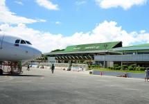
Barnaul is a large business, cultural, industrial, transport and tourist center in the south of Siberia.
Airport them. Herman Stepanovich Titov receives aircraft from different cities of Russia and abroad. Railway connects the city with the Trans-Siberian railway, with the cities of Kuzbass and Kazakhstan. A bus network has been developed, including with major cities in Western Siberia and Kazakhstan.
There are over 30 modern hotels in the city; more than 150 travel agencies.
Of the large number of attractions in our city, it should be especially noted:
- Demidovskaya square with its unique architecture;
- Altai State Museum of Local Lore - oldest museum Western Siberia, other city museums;
- Arboretum of Research Institute of Horticulture of Siberia named after Mikhail Afanasyevich Lisavenko;
- river Ob;
- tape pine forest;
- Altai Regional Drama Theater. Vasily Makarovich Shukshin;
- State Youth Theater of Altai.

barnaul-g. Aleysk-s. Pospelikha-s. Kurya
Heading along the route from Barnaul, tourists are impressed by the change of amazing landscapes from the vast steppes in the Aleisk region to the Altai foothills in the Kurya region.
Aleysk is a kind of geographical center of the Altai Territory, in the local history museum of which unique exhibits are collected. The city is located on the banks of the Aley - the longest river in our region.
The village of Kurya was founded in 1749. The world famous small arms designer Mikhail Timofeevich Kalashnikov was born here.
On this section of the route, tourists can see a number of interesting objects, the most significant of which is the memorial complex of Mikhail Timofeevich Kalashnikov. 
S. Kurya - s. Savvushka - Zmeinogorsk - s. Old Aleyskoye-border with the Republic of Kazakhstan
Zmeinogorsk was founded in 1736 as a settlement, after deposits of rich silver-lead ores were discovered. Zmeinogorsk fortress was part of the fortifications of the Kolyvano-Kuznetsk defensive line. The city developed as a center of mining and ore production and for more than a century remained the main supplier of gold and silver to Russia.
On this site, there are seasonal and year-round accommodation facilities and rural estates. There are also ski slopes.
The main attractions that are of interest to tourists are:
- Lake Kolyvan is famous for the fact that a water nut - chilim - a relic of preglacial flora grows here;
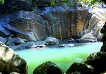
- rock complexes in the vicinity of the village. Savvushka;
- Museum of the history of mining in Altai named after Akinfia Nikitich Demidov in the city of Zmeinogorsk;
- Snake Mountain and a pond on the river. Korbolikha in Zmeinogorsk;
- Gilevskoe reservoir near the village. Staroaleiskoe
The village of Kolyvan was founded in connection with the construction of the Kolyvano-Voskresensky copper and silver smelting plant in those places in 1727. Now this settlement is famous for the Kolyvan stone-cutting plant named after I. Ivan Ivanovich Polzunov, where the famous "Tsarina Vaz" was made, on display in a separate hall of the Hermitage.
There are year-round and seasonal accommodation facilities on Lake Beloye.
On this section of the route, interesting display objects are:
- Mine of the Voskresensky mine near the village. Kazantsevo;
- A memorial sign at the site of the first copper-smelting furnace in 1724. near with. Kolyvan;
- stone cutting plant named after Ivan Ivanovich Polzunov;
- Museum of stone cutting in the village. Kolyvan;
- Lake White and Mount Sinyukha.

MOUNTAIN STUD ROUTES
This territory is the "heart" of the newly created Gornaya Kolyvan tourist cluster. Within the framework of this cluster, most interesting routes, which will be offered to tourists next summer.
- "In the depths of the Altai ores." The route is associated with the use of mining facilities. Part of the route follows the route of the expedition of Alexander von Humboldt, who visited Gornaya Kolyvan in 1829.
- “Kolyvan Kamnereznaya”, an off-road automobile tourist route, includes an excursion to the deposit of colored stone, and partly the route of its delivery to the Kolyvan grinding factory.
- "Gorno-Kolyvan Around the World".
The route passes through the places of the Academic Expedition led by Peter Simon Palace, completed in 1770-1771.
— « Unsolved mysteries Mountain Kolyvan ”, the route includes a visit to the caves in the Charysh river basin, rafting, acquaintance with the polymetallic mines of the Demidov and Soviet eras, as well as the sanctuary of ancient people on Mount Charming and much more.
- "Prospecting", an adventure tour is an expedition in search of treasures, with the provision of the opportunity to wash the golden sand in the waste of gold mining, reaching a taiga river lost in the mountains. 
from. Bugryshikha - s. Chineta - s. Charyshskoe
Many archaeological sites are of great interest for educational tourism. Absolutely uninhabited middle mountains with peaks up to 2.5 thousand meters are favorable for active, extreme and ecological tourism tours.
In with. Chineta and S. Charyshskoye has year-round and seasonal accommodation facilities.
On this section of the route, travelers are interested in:
- rivers Belaya, Inya and Charysh, as well as mountain landscapes of interfluves.

from. Charyshskoe - with. Small Baschelak - with. Soloneshnoe
The Charyshskoe village was founded in 1765 on the bank of the Charysh river, which is suitable for rafting. Here several years ago Vladimir Vladimirovich Putin made his first water trip along the mountain river.
Not far from the village. Soloneshnoe, founded in 1828, is the famous Denisova Cave. This place is an archaeological cultural monument. In with. Soloneshnoe and with. Maly Baschelak has year-round and seasonal accommodation facilities.
On the territory limited by this section of the route, tourists will be able to see:
- mountain landscapes between the Charysh and Anui rivers;
- the spurs of the Baschelak ridge;
- the Anui River.
ROUTES IN SOLONESHENSK LAND

Several routes have been developed on the territory of the Soloneshensky district, which will be presented next summer:
- "Antiquities of the Altai Territory";
- "Who are you" Man of Altai ";
- "Cradle of Humanity";
- "Sibiryachikhinskie caves";
- "The Caves of Anui".
from. Soloneshnoe - with. Medvedevka - s. Bolshaya Tikhaya - with. Bulatovo - with. Altai
In with. Iskra, p. Nikolskoe and s. Altai there are objects of year-round accommodation, and in the village. Topolnoe, s. Bolshaya Tikhaya operates rural tourism estates. Near s. Tog-Altai and Denisova Cave are seasonal accommodation facilities.
- mountain landscapes between the Anui and Peschanaya rivers;
- spurs of the Anuisky ridge;
- Peschanaya river;
- Arboretum "Biolit" s. Altai;
- museum of local lore with. Altai.

from. Altai - with. And I
The Altayskoye village was founded in 1808 and was a large merchant center. One of the largest and longest villages in the Altai Territory.
In with. Aya and its environs operate year-round and seasonal accommodation facilities, panto-health centers.
Also in the vicinity of the village. Altai and s. Aya there are ski resorts.
In this part of the route, tourists can visit Lake Aya - a favorite place for vacationers, which is a natural monument of the Altai Territory.
"Turquoise Katun"

"Turquoise Katun" is the only one of the created zones of a tourist and recreational type, which already now receives tourists and excursionists on its territory.
There are already year-round and seasonal accommodation facilities, as well as ski slopes.
Tourists can visit:
- warm artificial lake;
- the famous Tavdinsky caves;
- Archaeological Park "Crossroads of the Worlds" with authentic mounds of the Turkic era;
- a monument to Nikolai Konstantinovich Roerich - the famous traveler, artist and philosopher.

from. Freedom Valley - with. Krasnogorskoe-s. Bystryanka
The village of Krasnogorskoye was founded in 1811. In honor of Agey Antonov, the creator of the first hydroelectric power station in Siberia, an 8-meter stele was installed in the center of the village.
In the region there are tourist centers for year-round accommodation and rural tourism farmsteads.
Of interest for tourists are:
- Isha river;
-Karaguzhinsky creamery with its showroom and the opportunity to taste the products of the plant;
- mountain landscapes between the rivers Katun and Biya.

from. Concretions
The village of Srostki was founded in 1804. Vasily Makarovich Shukshin was born here - a famous writer, film director, actor. In his honor, "Shukshin Readings" are held annually. At any time of the year, tens of thousands of people stop on the banks of the Katun, climb to the top of Mount Piket, which our great countryman loved and sang so much in his works.
As objects of interest for tourists are recommended:
- memorial reserve of Vasily Makarovich Shukshin, museum, parents' house, mother's house, "Kameshki";
- Mount Piket and a monument to Vasily Makarovich Shukshin;
- the Katun river.

biysk, Biysk district
The city of Biysk, founded in 1709 by the personal decree of Peter I, has a rich historical past. It is a science city, as well as the second largest business, cultural, industrial and tourist center Altai Territory.
In Biysk and in the Biysk region there are year-round and seasonal accommodation facilities, a ski slope.
Tourists in the city of Biysk and the Biysk region will be interested in visiting such display objects as:
- Ethnopark "Legend";
- Museum of Local Lore. Vitaly Valentinovich Bianchi;
- an old merchant town with its rich history;
- Uspensky cathedral;
- Bishops' courtyard, Museum of the history of the Altai spiritual mission;
- Church of St. Alexander Nevsky;
- the place of formation of the greatest river on the planet Ob.

from. Tselinnoe - with. Yeltsovka - border with the Kemerovo region
The village of Eltsovka was founded in 1770. This is the birthplace of the famous actress Ekaterina Fedorovna Savinova, known for her role in the film "Come Tomorrow".
In the vicinity of the village. Yeltsovka operates a rural tourism estate.
Of interest are:
- Chumysh river valley;
- mountain landscapes of the Salair ridge;
- Museum of Ekaterina Savinova in the village. Yeltsovka;
- the famous Pashtulim marble.

Kosikhinsky district
The village of Kosikha is the administrative center. The famous Soviet songwriter Robert Rozhdestvensky (1932-1994) was born here. Christmas Readings are held annually in his honor.
The village of Polkovnikovo is the birthplace of cosmonaut German Stepanovich Titov.
Currently, the village has an Altai state museum German Stepanovich Titov.

The general characteristics of the route roads are shown in the diagram:

The creation of an interregional cross-border tourist route in the Altai Territory is not only an important area of \u200b\u200btourism development, but also a large-scale project of socio-economic development of both municipalities and the Altai Territory as a whole.
Click to enlarge
1. Belokurikha

Belokurikha, Altai Territory Photo: Commons.wikimedia.org / Anton Denisenko
Belokurikha lies in a green valley among lush grasses and low mountains. In this extraordinary resort city, the sun shines more often than in other places - 260 days a year. Siberia, but some kind of non-Siberian: the climate is mild, the winters are warm, there are sanatoriums right there, skiing, mineral springs, paragliders ... And, of course, horseback riding, thanks to the breeding horse farm with purebred horses.
2. Relic tape burs

Altai. Relict tape burs. Photo: Sergey Kireev
About a million years ago, it got noticeably colder on Earth, and then, as usual, it got warmer and the glaciers melted. Then the waters from the foothills of the Altai rushed along the ancient channel of the Ob to the north, but the ice dam forced them to turn towards the Irtysh. Later continental ice descended, and the Ob and its tributaries laid their own channel, which is very similar to the current one. On the remaining layers of sand brought into the hollows by ancient rivers, unique ribbon pine forests have grown. The largest belt originates from the Ob River near Barnaul and stretches for almost 400 km. Its width in some places reaches 15 km.
3. Tsar's mound
Charyshsky District of Altai Territory

Tsar's mound. Charyshsky District of Altai Territory. Photo: Vera Salnitskaya
Kurgan, which is located in the valley of the Sentelek River, is almost two and a half millennia old. You can find it near the country road between the villages of Sentelek and Pokrovka. In the center of the mound there are huge stone pillars - this is the answer of our ancestors to the British Stonehenge. Some scholars say that the stone pillars standing in a row served as an observatory for the ancients: at sunrise, on the day of the equinox, the shadows from all the steles converge.
biysk city

Bishop's courtyard. A photo: Valery Stepanyuk
It was Biysk that in the second half of the 19th - early 20th centuries was the center of the Altai spiritual mission, the heart of which was the bishop's courtyard. This is a kind of city within a city, where there was even a place for parks and reservoirs. Today it is a museum where an artifact is kept: one of the first printed books of Russia "Octoich", published in Moscow in 1618. There are also unique Orthodox collections of icons, copper casting, old printed books, pectoral crosses and other amazing things.
5. Lake Light
Sovetsky District of Altai Territory

Lake Svetloye Photo: Valery Stepanyuk
Snowdrifts, ice floes, glass trees from frost, steam rises from the warm water ... And here snow-white swans sliding along the dark surface fall into this mezzanine. What is this - a mirage, an optical illusion? No! Almost half a century ago, on a small non-freezing lake, a small flock of wild whooper swans suddenly remained for the winter. And every year they began to return, already with offspring. Now up to five hundred beautiful white birds winter here, and these lands received the status of a reserve. This miracle is located on the Pre-Altai plain among the meadow steppes and ancient terraces of the Katun.
Altai District of Altai Territory

Turquoise Katun. Photo: Commons.wikimedia.org / Ondřej Žváček
In Altai legends, this river is a wayward khan's daughter, unpredictable and changeable. Muddy and angry in spring, in autumn she calms down, repainting the waters in emerald. For this inconstancy, we have to thank the weather: in spring and summer the river is fed by rain, snow and glaciers. And when the gray water disappears, only pure underground waters remain in the Katun, and it becomes turquoise. It is here that a unique tourist zone is located, which is called “Turquoise Katun”.
yarovoe town

Lake Yarovoe. A photo: Sergey Lukyantsev
The lake is famous for its bitter-salty mineralized water and medicinal silt mud - it is not for nothing that it is called the Dead Sea! Naturally, on its shores one can find not only beaches full of entertainment "on land and on water", but also balneology in all its forms - from a sanatorium to a hospital.
Car travel in Altai can be of different length and duration. These are weekend hikes and multi-day non-categorical trips for motorized tourists in Altai Territory and the adjacent Novosibirsk, Kemerovo and Pavlodar regions.
For motorcyclists from the central regions of the country, a hike in Altai will be an integral part of the multi-thousand-kilometer route house - Altai - house. Therefore, when classifying routes in Altai, only the region was taken into account, through which the most difficult, defining part of the hike passes, without taking into account the approaches to the starting point of the route.
1. Barnaul - Aleysk - s. Pospelikha - s. Kurya - s. Kolyvan - s. Bugryshikha - s. Chineta - s. Sentelek - s. Korgon - s. Ust-Kan - s. Black Anui - s. Ilyinka - s. Cherga - Gorno-Altaysk - s. Choya - s. Artybash - with. Turochak - Biysk. The length of the route is about 1000 km. 4 category of complexity.
2. Rubtsovsk - Zmeinogorsk - s. Kurya - s. Kolyvan - s. Bugryshikha - s. Chineta - s. Krasnoshchekovo - with. Alekseevka - s. Sentelek - s. Ust-Kan - s. Ust-Koksa - with. Ka-tanda - s. Inya - s. Ongudai - s. Shebaline - Gorno-Altaysk - Barnaul. The length of the route is about 1,500 km. 5th category of complexity.
Tourists will get acquainted with the most interesting regions of Altai. Chains and a tow rope are required to traverse a number of sections. Tourists can visit the museum of the great weapons designer Mikhail Kalashnikov in Kurye, the Museum of Stone Cutting (the birthplace of the famous Queen of Vases), mines and mines in Kolyvan, see the unique Tsarskoe Kurgan in the Sentelek River Valley and much more.
The route has technically difficult sections. For lovers of mountain-forest roads, this route can be recommended in a slightly modified version:
from. Shebalino - ascent to the Cherginsky ridge - with. Baragash - s. Ilyinka s. Tourak - s. Nikolskoe - pass through the Cherginsky ridge - vil. Altai - Biysk - Barnaul.
Officially. Altai Territory is located in the southeast of Western Siberia, 3419 km from Moscow. Territory 168,000 square kilometers.
Informally. Altai Territory is very large and varied. The topography changes as you move through the territory. He is, as if, a growing bear, at first quiet and calm, then huge and majestic. So the steppes and plains grow into foothills and mountains.
Officially. The climate is temperate continental, formed as a result of frequent changes in air masses.
Unofficially. The four seasons have many options, and each year come back to see them from different angles. You can come in a hot summer, or you can come in cool and rain. Give variety! - this is the main rule of Altai weather.
Summer and Altai Mountains
Officially:The Altai Mountains are a complex system of the highest ranges in Siberia, which are separated by deep valleys of mountain rivers and vast basins located inside the mountains.
Informally: Altai nature is amazing. Tourists from all over the world rush to these places to enjoy beautiful views of high mountains, mountain rivers, mysterious caves and deserted spaces. Immerse yourself in the tranquility and beauty of these places.
The settlement of the Altai Territory began
in the eighteenth century
Young Russia needed metal for the production of weapons and coins. Ural factory owner Akinfiy Demidov founded in 1729 the first metallurgical plant - Kolyvano-Voskresensky. The bowels of Altai were rich in silver as well. In 1744 Demidov started the production of silver. The result of the activities in the Altai Territory of Akinfiy Demidov was the establishment of a feudal mining industry based on the serf labor of registered peasants and artisans.
Event tourism in the Altai Territory
The creation and development of bright, interesting events in the business, cultural, sports life of the Altai Territory became the basis for development in the region event tourism... The region annually hosts more than a dozen festivals, forums, holidays that can attract thousands of tourists from various regions of Russia and from abroad. These are the VISIT ALTAI International Tourism Forum, the Maralnik Blossom holiday, the Altayfest beverage festival, the Day of Russia at the Turquoise Katun, the Shukshin Days in Altai Festival, the Asia-Pacific International Youth Forum, the SCO Forum, the Siberian International Health Forum and medical tourism, the holiday "Altai wintering" and many others.
Tourist routes Altai Territory. The Altai Territory, highly endowed with such important factors for the development of tourism as rich natural-recreational and historical and cultural resources, is not like other popular places of recreation and tourism. High mountains, mountain valleys, alpine meadows, cedar forests, mixed forests on mountain slopes, mountain rivers with rifts and waterfalls, many large and small lakes, warm, sunny and dry summers, clean air - all these features altai nature attract tourists here not only from Western Siberia, but also from the European part of Russia. The main tourist routes pass along the main transport artery of the Altai Mountains - the Chuisky tract. It stretches for 600 km from the city of Biysk, where Biya and Katun merge, forming the Ob, to the border with Mongolia near the village of Kosh-Agach. The most popular tourist route in Altai runs along the Chuysky tract through the tourist base "Katun" on the banks of the river of the same name, the village of Srostki, the birthplace of the writer V. M. Shukshin, and the capital of the Gorno-Altai Republic, the city of Gorno-Altaysk. At 109 km from Biysk, tourists cross the river. Katun near the tourist base "Yunost", near which, near the village of Ust-Sema, from the Chuysky tract, there is a road to the mountain-climatic and kumis resort of Chemal (180 km from Biysk). After the passage of the Chuisky tract to the left bank of the Katu, the path of tourists lies along the valley of the river. Semy among mountain forests and alpine meadows, gradually climbing the Seminsky pass, from which a beautiful view of the surrounding mountains opens. After the descent, the tract rises to another pass, Cheke-Taman, and passes to the right bank of the Katun, and then along the valley of the river. Chui descends to the village of Kosh-agach. The second popular tourist route - to the Teletskoye lake - departs from the Chuisky tract; the road to it goes from Gorno-Altaysk to the r. Biya, to the village of Artybash located on the right bank. Teletskoye Lake is the largest in Altai. It stretches for 78 km with a width of 5 km, having depths of up to 325 m. The lake is framed by steep cliffs and inaccessible capes, overgrown with forest peaks. 71 rivers flow from the coastal mountains. On the lake, tourists make boat trips from the tourist base "Golden Lake" to the Altai nature reserve. Tourists are also interested in boat trips on the lake and walking along its shores. In addition to travel along the Chuysky tract and the roads branching from it, water routes by kayaks and rafts along the Biya River (from Artybash down to Biysk), along the Chulyshman River (to Lake Teletskoye), along the Chuya River (from the Chibit village) are of great importance in Gorny Altai. on the Chuisky tract to its mouth), etc. Horse routes along mountain valleys Altai and ski tours in winter. The Kulunda steppe, located in the southeast of the West Siberian Lowland, is rightfully called the "land of a thousand lakes", and it is the lakes that attract most tourists here. If you look widely (and in the steppe it is impossible to do otherwise), then the entire Kulunda lowland is one very big attraction. It is the lowest in Altai, the sunniest. The bottom of the ancient sea, strewn with lakes, bordered by unique, nowhere else on the planet, ribbon pine forests. And besides this, there is also a living illustration of the history of the country, those very virgin lands about which songs were composed throughout Russia in the last century. a) Kulundinskoe lake: many come to the depths of the steppes to see the "Altai Sea" - the largest lake in Altai, the Kulundinskoe lake, its water area is 728 sq. km. The lake is shallow, on average 2.5-3m, the water is slightly salted and very warm (summer temperatures +22 -25 C). Around the lake there is a typical steppe landscape, along the shores there are many convenient sandy beaches... There are great places for swimming and boating on anything from a regular boat to a jet ski. It is good to have a rest with children, the open shore and shallow water ensure safety, warm water and sun are a pleasure. The Kulunda River flows into the lake, where, with some patience and luck, you can catch a perch or pike. b) Borovoye lakes: in the south-west of the steppe, in the Kasmalinsky tape forest, there is a scattering of salty, bitter and fresh water bodies of the most different sizes and forms - Borovoe lakes. The largest of them is Crimson, so named because of the crimson hue of the water. In all salt and bitter lakes, water and mud have medicinal properties; it is convenient to rest near fresh water bodies. You can swim in all in turn, the lakes are shallow, there are many natural beaches. In the forest in the season, you can enjoy wild raspberries, bones, lingonberries or pick mushrooms. Healing waters of Borovoe lakes, life-giving air pine forest and the hot sun create ideal conditions for simultaneous relaxation and recovery. c) The Kolyvan ridge stretches in a latitudinal direction along the border of the Altai Territory and Kazakhstan. To the north and west of the ridge lie foothill plains, in the south - the low Kipishnye mountains, in the southeast stretches the valley of the Belaya River, behind which the Tigirek ridge rises. The average heights of the Kolyvan ridge are 500-1000 m, highest point - Mount Sinyukha (1210 m). Climbing Sinyukha (1210m) is a kind of ritual for the guests of Gornaya Kolyvan. This is a wonderful observation point, a convenient gentle path leads to the top, surrounded by picturesque rocky outcrops - "stone palaces". On the slopes of Sinyukha Lake Mokhovoe is located, a natural monument - a deep stone bowl with the purest water, at the foot of a cliff among a pine forest. You can climb Sinyukha only on foot - the ascent, although very simple, takes a whole day, but the beauty of the surrounding nature is more than worth the effort. It is curious that local landscapes are most often perceived as a series of separate, perfectly completed pictures: a rock, a lake, a glade in the forest ... And in contrast - a panoramic view from the top of Sinyukha. d) Lake Kolyvanskoe: a relatively small lake (length 4 km, width 2-3 km) is famous for its clear water, bizarre granite rocks scattered along the banks, and a unique water nut chilim. This plant is considered a relict preserved in some lakes of Altai from the pre-glacial period. This old resident of our places should be treated with respect. In order to make out the bizarre shape of a walnut, similar to a black imp, it is enough those specimens that the waves carried to coastal sand... Chilim is listed in the Red Book and requires protection from destruction. f) The Charysh River is one of the largest rivers Mountain Altai; its length is 547 km, of which 447 km are across the Altai Territory. It originates from the Korgon ridge and rushes to the north-west, in order to merge into the Ob after 547 km. Almost half of its way, the river passes through mountainous terrain, collecting the right tributaries from the slopes of the Baschelak ridge, and the left tributaries from the Korgon, Koksu, Tigirek and Kolyvan ridge. The mountainous part of the Charysh basin together with the surrounding ridges is also called mountain Charysh. The most famous and popular among tourists and vacationers is a picturesque place called Devichiy Ples, located in the upper reaches of the river. An idol in the Korgon ridge. An unexpectedly calm backwater formed by a mountain river, a combination of gently sloping shores and rocks that go into clear water, creates a landscape unique in its beauty. Water tourists, rafting down the rivers in the Charysh basin, like to stop here. In summer, there are a lot of tourists on Devichye Reach; from the village of Ust-Kan, a dirt road leads here, in dry weather, passable for cars. h) Denisova cave: located on the banks of the Anui, near the village of Cherny Anui. The wide entrance to the cave opens directly into the side of the mountain, a few meters above the road. Since 1982, archaeological research has been conducted here, more than 20 cultural layers have been discovered, belonging to different epochs of human development. The most ancient artifacts are about 300 thousand years old; many finds are kept in museums in the Altai Territory and Siberia. The oldest human remains in North Asia were discovered in Denisova Cave, their age is 42 thousand years! Archaeological research continues, new sensational discoveries are possible. g) 15 km from the cave there is a cascade of waterfalls on the Shinok River, the largest in the Altai Territory. The three-stage waterfall has a total height of about 70 m. This miracle of nature was discovered relatively recently. Previously, only knew about the waterfall localshowever, they were not too interested in him, as having no practical application. In recent years, there have been many tourist groups, receiving great aesthetic pleasure from a magnificent spectacle. k) In the Altai region there is a beautiful lake Aya. This is one of the most visited places not only in the region, but in the region in general. The "Blue Pearl" attracts nature lovers like a magnet. Aya lies at an altitude of 280 m above sea level and 75 m above the Katun level, on an ancient coastal terrace. The dimensions of the lake are small (about 300 x 400 m), as if it is hidden among the surrounding mountain slopes. On one side, a rocky cliff drops into the water, on the other - a low bank is bordered by a tangle of trees and bushes. A small (20 x 6 m) island with several pine trees gives a special charm to the landscape. The bottom of the lake drops rapidly from the shores, the depth reaches 20 m or more; the water is clear 6-8 m deep. m) In the Zarinsky region, in the valley of the river. Chumysh is a man-made cave Orthodox church. It was created at the beginning of the 20th century by the monk Daniel, who put 12 years of his life on this ascetic labor. Underground cells, galleries, labyrinths have a total length of about 250 m and are very similar in layout to the Kiev-Pechersk Lavra. The largest room is a 4 x 5 m altar room with a domed ceiling. This is the only cave in Russia temple complexunfortunately abandoned. Orthodox believers come here to worship the shrine and do not lose hope that someday in this unique temple prayers and services will be performed again.
Introduction
The main purpose of transport is to carry goods and passengers, and road transport has ceased to be a luxury and has become an integral part of our life.
One of the most effective reserves for increasing the car park is car repair, so much attention is paid to its development and improvement in our country.
The clients of the projected service station will be the owners of passenger cars who have become faulty or lost their performance on the way, as well as local residents who have automobile transport.
The production base of the service station will consist of six posts. This will allow performing diagnostics, tire fitting and washing work, etc.
Problems, purpose and objectives of the diploma project.
Problems:
¾ on the Biysk highway section ¾ Soloneshnoe, there is not a single road service station capable of providing high-quality repairs;
¾ low degree of market development of demand 11%;
¾ insufficient range of services in the area.
Therefore, the purpose of the diploma project is to design a road service station for passenger cars on the Biysk highway ¾ Salt, which could satisfy the need for maintenance and car repair and making a profit.
To achieve the set goals, it is necessary to solve the following tasks:
¾ analyze marketing research;
¾ perform a technological calculation of the service station;
¾ make the selection of technological equipment, technological and organizational equipment;
¾ to develop a technological process for the restoration of alloy wheels;
¾ develop measures for the safe conduct of work, calculate the lighting and grounding of the service station;
¾ to calculate the economic efficiency of design solutions.
Justification of the topic of the diploma
Tourist routes of Altai Territory
One of the activities of the Administration of the Altai Territory within the framework of the implementation of a long-term target program is the development of tourist routes that contribute to the popularization of existing and under construction tourist facilities, the redistribution of tourist flows across the Altai Territory and the consolidation of efforts of the regional authorities and the business community to expand the list of services provided to tourists and improving their quality.
One of the projects within the framework of this event was the creation of a branded tourist route "Small Golden Ring of Altai".
Figure 1.1 ¾ Scheme of the route "Small Golden Ring of Altai"
In just a few days, vacationers will be able to get acquainted with the beauty and diversity of the nature of the Altai Territory, its historical and cultural heritage, wonderful people. The route passes through two cities and four districts of the region. These are the cities of Biysk, Belokurikha, the regions of Biysk, Krasnogorsk, Altaysk and Smolensk. Its total length is 280 km, and, depending on the content of the excursion program, its passage takes from two to five days.
Considering the positive experience in the implementation of this project. The Governor of the Altai Territory set a more ambitious task - to develop a new tourist route that would show not only the beauty of the Altai mountains, but also amazing landscapes and objects of one of the largest plains in the world ¾ West Siberian.
The interregional transboundary tourist route “Big Golden Ring of Altai” became such a project.
The route runs along the southeastern part of the West Siberian Plain, as well as along the valleys and passes of the northern ranges of Altai and includes visits to four cities and 22 districts of the region.
The length of the route is about 1500 km.

¾ route "Big Golden Ring of Altai"; ¾ radial routes
Figure 1.2 ¾ Scheme of the route "Big Golden Ring of Altai"
The territory along which the route passes has an interesting history. In the middle of the 18th century, the Kolyvano-Kuznetsk defensive line was created here between neighboring defensive structures in order to protect against the raids of the militant Dzungars, its distance did not exceed forty versts. Military service was carried out by the Russian Cossacks. Until now, from the city of Ust-Kamenogorsk in Kazakhstan to the city of Novokuznetsk in the Kemerovo region and mainly in our southern part of the Altai Territory, the descendants of the Cossacks live and preserve their traditions.
Traveling along the "Big Golden Ring of Altai" allows you to visit not only these historical sites, but also make a trip to the Cossack settlements of Kuzbass and Kazakhstan. Taking into account also the fact that the route passes along a part of the Chuysky tract located on the territory of the Altai Republic, and the territory of the Talmensky district borders on Novosibirsk region, it is possible to rightfully assign the "Big Golden Ring of Altai" the status of an interregional transboundary tourist route.
The creation of an interregional cross-border tourist route in the Altai Territory is not only an important area of \u200b\u200btourism development, but also a large-scale project for the socio-economic development of municipalities in the Altai Territory.
All these events contribute to the creation of an attractive image of the region as the largest tourist territory in Russia, as well as the development of automobile service in the Altai Territory.
1.2 Natural and climatic indicators
The Smolensk District of the Altai Territory is located in the southeastern part of the Territory. There are 31 locality, the largest villages: Anuyskoe, Solonovka, Sychevka, Tochilnoe, Novotyryshkino; villages: Linevsky and Verkh-Obsky. There are 11 intra-district municipalities on the territory of the district.
The relief in the northern part is rugged and flat; in the south - hilly, foothill.
The climate is continental. Average January temperature -16 ° C, July 20.2 ° C. Annual precipitation - 630 mm.
The following rivers flow through the territory of the district: Ob, Katun, Anui, Sandy, Kamenka, Poperechka; there are more than 20 lakes and ponds, the most large lakes: Komlevo, Rogulichnoe, Zakharovo, Pavlovo.
Growing: pine, birch, poplar, elm, maple, spruce, larch, sea buckthorn.
Inhabited by: roe deer, bear, elk, fox, hare, wild boar, badger, polecat.
Socio-economic development of the region
The main direction of the economy is agriculture. The main industry is crop production with developed animal husbandry. In the region there is LLC Linevsky breeding plant, poultry farm of KGUP “Poultry farm Smolenskaya”, antler reindeer breeding is developing.
There are 18 general education and 12 preschool institutions, Houses of culture, clubs and libraries.
On the territory of the district there are motorways: Biysk - Belokurikha, Biysk - Aleysk, Biysk - Petropavlovka, Biysk - Soloneshnoe.