There are many interesting and picturesque corners on our planet, where once, once, you want to return again and again. One of such corners is Bohemian Switzerland or, as the locals call it, Saxon Switzerland.
This park was founded not so long ago, at the beginning of the two thousandth. Its territory is about 80 sq. km. When creating the park, the country's authorities wanted to preserve the area of \u200b\u200buntouched nature in its original state. And they succeeded. It has stunningly beautiful places with minimal human intervention.
The basis of the park is made up of unique sandy formations in the form of rocks. The rocks are covered with ancient forests with rare plant species. It is believed that the rocks were formed about 10 million years, and over time, when the water receded, the rocks, on the contrary, protruded. These sandy deposits were compressed mainly during the Mesozoic period under the influence of wind, temperature changes and other natural phenomena.
Unique natural formations impress with their picturesqueness: canyons, arches, windows and more. And the ruins of fortresses and other medieval buildings, which have been perfectly preserved to this day, very harmoniously fit into all this. Many photographers come here to capture the unique beauty of these places.
History
For the first time, nomadic tribes of hunters and gatherers began to inhabit this territory about 10 thousand years ago. They settled mainly near water bodies. Still locals after the spring floods, ancient tools and dishes are discovered.
A little later, farmers began to settle in these places, for whom the lands along the tributaries of the river were the most fertile. Over time, to strengthen their settlements, people began to erect walls and even build forts, the ruins of which are scattered throughout the national park.
In the 14th century, Saxon colonialists settled on these lands, who were engaged in logging. In those days, there were real impassable thickets here. They also settled here, in some places even the ruins of entire settlements with specific architecture remained.
But it was precisely two Swiss restorers who made this area a tourist destination, who were invited to Dresden to restore one estate. During their holidays, they often walked through the modern territory of the national park from the side of Dresden and admired the beauty of these places. And at the end of the work they stayed here to live, because the local rocks reminded them very much of their native Switzerland. So the name "Switzerland" stuck to this place. Since the end of the 18th century, this area has been called “Saxon Switzerland”.
In the 19th century, local communities opened the first tourist routes for travelers. The mining society of Bohemian Switzerland began to open the first hotels and restaurants here. They began to equip observation platforms and clear the most beautiful gorges. And on the river Elbe everything was equipped for those who like to swim under sail. In general, we have equipped everything for a comfortable stay of tourists in these places.

Where is
The park is conditionally divided into German and Czech parts, which are divided by the border between the states and the Elbe River in the west of the park.
Bohemian Switzerland is located in the northern part of the Czech Republic, close to the border with Germany and 40 km. from Dresden. The highest part of this park is Mount Decinsky Snezhnik with a height of just over 700 meters. The most popular tourist destination is the Pravcicke Gate, which was formed by rains and severe erosion.
How to get there

In fact, there are only two options to get to this fabulous place: on your own in a rented or your own car, or with a guided tour. Sightseeing tour can be bought at any travel agency c. The cost of such a tour is from 30 euros and more, depending on the number of people in the group. You will also have to pay separately for visiting certain attractions.
If you get there on your own, you can enter the park both from German territory and from the Czech Republic. You can enter the National Park in different ways: along the autobahn and along simple roads. But it is worth using a map or navigator in order not to get lost.
You can also take a train from Prague to the city of Decin, and then to the village of Khrzhensky, take bus number 434.
When is the best time to go?
Park opening hours - all year round... From November to March, the park is open from 10.00 to 16.00. And from April to October 10.00 - 18.00.
Spring and autumn are considered the best times to visit the park, when it is not very hot, and you can devote a lot of time to walking and relaxing.
The entrance ticket can be bought at the entrance to the park, it costs 70 CZK. Additional excursions will have to be paid separately. You can go boating in the park, with sightseeing tour along the gorge, or visit the castles.
Tourism
The entire territory of the park is marked with special hiking trails, which you cannot leave. Therefore, it is worth buying a park map right at the entrance. All trails are accessible. There are even routes for cyclists. You can rent a bike right in the park. There are also climbing areas in the park.
Lovers of rest in tents can spend the night right in the reserve, but this is allowed in special camp zones. Even pets are allowed to walk in the park, so you can safely bring your favorite pets for a walk.
For a more comfortable rest in the reserve and search for places in the park, there are several tourist centers located in different parts of the park. The main tourist center is located in Krasnaya Lipa. It works daily from 9.00 am until the closure of the park. There are also information centers in Khrzhensko, Saule, Serbian Kamenica.
When traveling to Czech Switzerland, you should definitely take comfortable shoes and clothes. It is hardly easy to get up the hill in heels or tight pants. You should definitely take a couple of bottles of water with you, as water is much more expensive in the park.
sights
Forests and rocks form the basis of the reserve. But even besides the stunningly beautiful landscapes, architectural sights can also be seen in the park.
Pravcicke Gate
The main attraction of the park is the Pravchitsky Gate Arch. The gate is the symbol of the park. Tourists tend to see this colorful and miraculous property. Nature has created this huge hole in the rock for many millennia. And only after passing through it, you can really admire the work of nature. The observation deck near the arch offers a stunning view of the canyon from below. But going up the arch is strictly forbidden.

Soklinoe Nest Castle
This castle is located near the Pravchitsky Gate. It was built in 1881 by one noble Czech family, literally within a year. The walls of the castle are built into the rock, which gives it extraordinary charm and simplicity. Dignitaries have always been received here. The castle has old interiors and a restaurant decorated in medieval style. The view from the restaurant is stunning, but the menu is meager, but the dishes are very overpriced.
Schaunstein castle ruins
They are another scenic spot that deserves attention. Once upon a time, robber barons lived in this place. The barons themselves did not build the castle, they simply seized the already built defensive fort and firmly settled in it, changing its name to "castle of thieves". You can climb to the ruins through a narrow gorge along a steep staircase thrown over a cliff. Today tourists come here to see the beautiful views from the observation deck near the ruins.
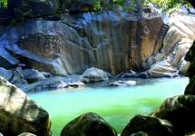
Kamenitsa river canyons
For a fee, you can see the beauty of the canyons from the gondola. During this trip, you can see a man-made waterfall leading to a cave with a pirate castle.
 Dolsk mill
This is another picturesque place, but it is located in a dense forest, and you cannot see the surroundings from it. The ruins of the fortress are used as scenery in films. By the way, it is believed that it was thanks to the films that this place became famous. The mill has operated since the end of the 14th century and has been destroyed for many years by the effects of natural phenomena. But having declared this area a nature reserve, the restorers took up the mill. And in 2007 the mill became a national architectural monument.
Royal spruce
Not far from the Dolskoy mill there is an ancient spruce, which is more than 180 years old, and the trunk of the tree has grown over three meters wide. Spruce is protected by the state no less than other monuments.
Falkenstein Castle
This is one of ancient sites parka. The castle was built in 1394 on a high hill. This structure was built for the purpose of defense against robbers. Climbing the walls of this castle was very difficult. Many parts of this castle have been perfectly preserved as they were carved into the rocks. Several legends are associated with it, one of which says that the robbers who wanted to capture this castle were caught. Then they were hanged. And soon angry dogs began to run around the castle, which can be found today in the vicinity of the castle. Locals believe that these are the very robbers who are trying to take revenge on their killers.
Mouse hole
Such a strange name has a staircase that leads to the top of the hill through a narrow gorge. There are a lot of steps near the stairs, and many tourists who go downstairs constantly shout "Wow!" It's hard to say why, but perhaps they admire their excellent physical shape. Initially, this staircase was called by the locals the staircase of the Angels. But the owner of the estate did not like the name, and he renamed it in his own way.
Khrzhipska
Everyone has heard about Bohemian glass, but no one knows that it is made not in Bohemia, but in a workshop in Czech Switzerland in the village of Chrzypska. Since the 14th century, the same Bohemian glass has been produced here, which was admired before and is still admired to this day. Today, excursions are not taken to production, but in the village you can buy products made of real Bohemian glass for almost a penny.
Belvedere observation deck
This is a huge rocky terrace located above the Laba River canyon. The height of the site is 130 meters. The Belvedere hotel was built not far from the site, from the windows of which you can enjoy stunning views of the surrounding area. This platform is considered the very first observation deck in Bohemian Switzerland. It was built by the owners of the estate, who owned almost the entire part of modern Bohemian Switzerland.
Silver mines Jirzetin pod Jedlova
In the ancient mines of these mines, precious metals have been mined for a long time. Today, in order to feel the spirit hovering in the underground, you can put on a miner's helmet with a lantern and go down into the mine tunnels. these mines first opened in 1474. Silver and copper have been mined in the mines for over two hundred years. But the Thirty Years' War forced the owners to cover up the production. When mining resumed several decades later, it turned out that it was already unprofitable and the mines were closed again. Today, excursion groups are taken here, showing and telling in all details how the process of mining takes place.
What else to see?
- You should definitely visit the city of Decin, which is located in the vicinity of Bohemian Switzerland. The main attraction of the city is Decin Castle, built in the 8th century. At various times, the Castle was both a military defensive structure and the residence of aristocratic families and even monarchs. The city also has a small zoo and a water park.
Video trip to Decin:
- Khrzhensko is a small village from which all excursions to Czech Switzerland begin. This is a nice and very hospitable place where you can relax and drink real Czech beer with German sausages. The village is located along the Kamenitsa river. The city is known for selling gnomes for vegetable gardens at almost every step, of various types, sizes, colors and for every taste.
A trip to Bohemian Switzerland is a seclusion with nature, acquaintance with unusual sandy rocks and a great chance to get acquainted with the sights created by Mother Nature herself.
Bohemian Switzerland is not only mystical landscapes of pine forests and picturesque valleys, majestic rock towers, gates, walls, gorges, rock towns and labyrinths of mountains, but also an unusually beautiful canyon of the Kamenica River, a walk along which will leave an unforgettable impression.
Here it is - Czech Switzerland!
Bohemian Switzerland (České Švýcarsko) is the Czech part of the Elbe Sandstone Mountains, a fantastically delightful corner of nature located in Northern Bohemia, close to the border with Germany. It has everything you need for a full-fledged active or simple rest: pristine dense forests, canyons, bizarre rocks, mountain rivers, picturesque valleys with rare plants.
Geographers believe that this area owes its unusual structure and beauty to the sea, the waters of which have covered this area since prehistoric times. Over time, the water receded and thanks to the influence of the most skillful designers - nature and wind, such a unique natural landscape was formed over the centuries.
What to see in Bohemian Switzerland?
Pravcicka brana
It is so incredibly beautiful that the state declared this place a national park of the Czech Republic in 2000. The park has many interesting places, but the most interesting attraction is the Pravčická brána, which is the largest natural gate formed from the rocky massif. Once upon a time, these gates were washed out of the rocks by the World Ocean itself. In 2009 Pravchitskie Vorota reached the semifinals of the international competition "Seven Wonders of the World".
Not without a castle. He seemed to be implanted into the rocks. And its name is appropriate - Falcon's Nest (Zámeček Sokolí hnízdo). It was built by Italian craftsmen in 1881 in a record time for that time - one year. The entrance to Pravchitskaya Brana is paid. But it's worth it. There is a small cafe right under the arch, and an observation deck, the views from which are breathtaking.
Decin
The Bohemian Switzerland National Park is located near the town of Děčín. This is where travel around the reserve usually begins.
The main attraction of the city is the Děčínský zámek, a military fortress and residence of influential aristocratic families.
The smallest zoo in the Czech Republic is the Zoo (Decina Zoo Děčín). It is located in the city center, in the city forest park and covers an area of \u200b\u200bonly 6 hectares. His specialty is growing rare species animals that can hardly tolerate life in captivity.
To relax and unwind, go to the city water park Decina (Aquapark) or to the Olešský rybník pond.
Khrzhensky
The beautiful and hospitable border town of Hřensko is located on the banks of the Kamenice River. Most of the hiking trails in the reserve start here. The city has everything for tourists - a tourist information center, large parking lots, hotels, guesthouses, shops.
Tolstein
Tolštejn - romantic ruins of a medieval castle. It was first mentioned in 1337. At one time it was the residence of local robber barons. Today, extraordinary views open from the walls of the castle.
Shaunstein
The Šaunštejn rock castle, built in the first half of the 14th century to protect trade routes, lost its significance after the Thirty Years War and became a haven for robbers. Now these are fabulous ruins in a dense forest. You can climb them only by a steep staircase in a narrow rocky tunnel. A breathtaking panorama will open from the top of the rocks.
Falkenstein
Falkenstein rock castle
Falkenštejn Rock Castle is one of the most popular places in Bohemian Switzerland Park. Unlike Schaunstein, everything remained as it was.
Souteski
The Kamenice river flows in a deep gorge. In two places, Tichá soutěska and Divoká soutěska, it is dammed. Here you can take a boat ride among the high cliffs, see trout under the stones, admire the fantastic stone figures and a huge artificial waterfall.
Suha Kamenice
Suha Kamenice is a small stream that flows into the Laba. Its valley is beautiful in spring and autumn when there is water. There are many waterfalls rustling between the majestic cliffs, the channel seems to be paved with cobblestones. When there is no water, silence reigns here.
Mouse hole
The Mouse Hole (Myší díra) is the name given to the Narrow staircase that leads to the top of the cliff. Back in the 19th century, many tourists came to climb the Mouse hole.
Khrzipksa
Do you know where Czech crystal is made? The world famous “Bohemian glass” is made in the village of Chřibská. It is here that the oldest glass production in Europe (15th century) is located.
Dolski Mlyn
Dolský Mlýn
The ruins of the medieval mill Dolský Mlýn are a romantic place lost in the forest. Several centuries ago, the mill occupied an important position.
Ruzhovsky Vrh
Ruzovský hill (Růžovský vrch) is a huge basalt volcanic cone. Hans Christian Andersen, who visited these places several times, called this mountain “Czech Fujiyama”. Although there are no tourist attractions on the hill, there are many viewpoints from which you can see amazingly beautiful nature.
Belvedere observation deck
The Belvedere observation deck (skalní vyhlídka Belvedér) is a huge stone terrace that seems to hang over the canyon of the Laba River. It is located at an altitude of 130 meters from the level of the river and is located near the town of Khrzhensk.
In 1640, a forester who killed two wolves carved his story on a stone slab. For a long time, the Wolf Board (Vlci deska) was covered with spruce that grew on it. But one day, during a storm, the tree fell and the slab opened. Now we can learn the story of a successful hunt. The road to the board leads through the beautiful Kiyovskaya valley, the Krinitsa river canyon.
Silver mines
Silver mines used to be mined in the old mines in the town of Jirzetin pod Jedlova. Today you can put on a real mining helmet with a lantern and descend into the stunning world of the dungeon.
How to get to Czech Switzerland
By car
First, head towards the town of Decin, and then Khrzhensky. There you can park your car and continue sightseeing on foot.
By public transport
By train you will reach Decin, and then go towards Khrzhensko by bus # 434. See the schedule with departure time and ticket prices.
On a boat
The motor ship on the Elbe river departs from Decin and from Dresden. See details. But keep in mind that you will have to walk about a kilometer to the pier, and then the same distance from the final stop to Khrzhensk.
How do I save on hotels?
It's very simple - look not only at the booking. I prefer the search engine RoomGuru. He is looking for discounts on both Booking and 70 other booking sites.
Previous photo Next photo


National Park "Bohemian Switzerland" (aka the national park "Bohemian Switzerland" was founded on January 1, 2000 and covers an area of \u200b\u200balmost 80 square meters. Km. The park is located on the northern border with Germany and continues on German territory (where it is called "Saxon Switzerland") The purpose of the park is to preserve the natural beauty of the local area, so that human intervention is strictly limited.
The main treasure of the park is the unique sandstone rock formations covered with green islands of well-preserved old forests and rare plants. These rocks once rose from the bottom of the sea, where sand has been collecting for 10 million years to reach a thickness of more than 1 km by now. The most important geological processes took place here in the Mesozoic.
The modern amazing landscape of the national park is represented by these sediments, pressed into cliffs, which cracked and split under the influence of wind, rivers, temperature changes, etc., forming to our days stunningly picturesque cliffs, rocky towers, canyons, arches and windows. The most famous of them is Pink Hill, the highest in Bohemian Switzerland.
The main treasure of the park is the unique sandstone rock formations covered with green islands of well-preserved old forests.
Bohemian Switzerland is a real forest kingdom. The forest covers almost all of its territory. Mainly coniferous-birch forests grow here, the oldest of which can be found in inaccessible gorges and on high rocks. Since the soil on the latter is either poor or absent, very viable representatives of the flora grow here, creating very picturesque paintings with their curved trunks. The fauna of the national park is also rich: the landscape creates ideal conditions for nesting of many species of birds, colonies of bats live in rocky crevasses, timid and nocturnal animals such as deer live in the forests.
History of Czech Switzerland
The first inhabitants of Bohemian Switzerland were probably hunters, fishermen and gatherers - which is natural for that time, more than 10 thousand years ago. They roamed the area, setting up settlements along the streams. Tools of labor, pieces of coal and dishes are still found here. Much later, Bohemian Switzerland was partially settled by farmers. From time to time, a fortified fort was erected here and there, and trade caravans went through the territory of the national park.
Hiking in Bohemian Switzerland
In the 13-14 centuries, Bohemian kings invited colonialists here from the territory of modern Germany. The latter built villas, stone castles, engaged in logging, began to produce glass and coal. But, since the forests were dense, and there were no wide plains in Bohemian Switzerland, the life of these communities had a specific character. The architecture was also specific: old half-timbered houses of a typical design (in particular, in Kamenicka Strana and Vysokaya Lipa) are still preserved in the national park. In the second half of the 20th century. many of these settlements, abandoned, fell into decay, and in some places in the park you can find the most picturesque ruins.
The tourist development of the region began quite early, in about the second half of the 18th century. The romantic artists living in Dresden began their first travels in what was later called Saxon Switzerland (the name was adapted in the Czech version). The systematic development of tourism began in the 19th century, when landowners from local estates (the Kinski and Clari-Aldringen families), as well as the first tourist communities (the Mountain Society of Bohemian Switzerland and the Mountain Society of North Bohemia) began to step by step increase the attractiveness of the region for travelers. The first walking trails, restaurants, hotels, observation decks and observation towers began to appear here. Fans of water sports increasingly came here to sail on the Elbe, and the gorges in Kamenice were full of punt boats.
Bohemian Switzerland Tourism
Today, dozens of well-marked hiking trails have been laid in the park. Here you can ride a bike, go horseback riding and rock climbing in the designated areas, and stop overnight at the official campsite. You can even bring your pets here.
But what is not allowed is to leave the marked trail in zone I of the park.
Today, there are several extremely interesting places on the territory of the national park, which tourists come to see from all over Europe. This is a natural stone arch 26 by 16 m, which is called the Pravcicka Gate; gorges of the Kamenice river; valley of the Krynice river; the famous rock Pink Hill; the town of Vysokaya-Lipa; Dolskaya mill; Dittersbacher peaks; waterfalls near Brtniki ... You can list further, but it is already obvious: it is not enough to spend a day or two in Czech Switzerland. It is worth coming here as if on a full vacation.
Practical information
Tourist centers are located in different parts of the national park. The most important is in Krasnaya-Lipa. Information centers are located in Saule, Jetrichovice, Serbska-Kamenica, Hrensko.
Opening hours of the tourist center in Krasnaya Lipa: daily from 9:00 to 12:00 and from 12:30 to 17:00, in January - February - until 16:00, in June - August - until 18:00.
You can get to Krasnaya Lipa by car in about two hours, if you go strictly north through Melnik and Cescu Lipa. Another option is to take the train to Germany, to Bad Schandau, which is located in the German part of the national park (Saxon Switzerland). This trip will take about two hours.
Saxony is famous for works of art, luxurious architecture of cities, ancient castles. This amazing land is also rich beautiful nature and cozy towns - resorts. In every trip we try to diversify the program. We decided to devote the second day of our trip to Saxony to natural attractions. The main purpose of this day is to visit the national parks of Saxon and Bohemian Switzerland.
Read the itinerary of the first day in Saxony here:
Saxon Switzerland is located just 50 km southeast of Dresden and 80 km from Meissen. And again here I will talk about the advantages of independent travel. In Saxon Switzerland, on the Bastei Bridge, they call tourist buses en route from Prague to Dresden. But Bohemian Switzerland is unknown tourist attraction for organized tourists. The city of Hřensko, the starting point of the Czech Switzerland route, is mainly visited by independent travelers. We combined these natural parks in one day route. The road passed through the town of Pirna, where we stopped for an hour. But first things first.
Itinerary for the second day in Saxony.
Meissen - Pirna - Saxon Switzerland (near Lomen) - Bad Schandau - Bohemian Switzerland (near Hrensko) - Decin (overnight).
Pirna is a cozy resort town.
The first stop on our route was Pirna. The town is located 25 km southeast of Dresden on the banks of the Elbe River. On an excellent German road, we did not notice how we arrived at Pirna.

First of all, we are looking for where to park the car. I really liked the organization of parking lots in this city, as well as in Germany in general.
Lots of parking spaces in the center, next to the Old Town. There are open parking spaces, but we chose a storey parking. Interestingly, instead of a restaurant or hotel in Pirna, a 4-storey parking lot has been built for about 80-100 cars.

Parking prices are available.

Everything is compact inside.

When we returned, we paid for parking at the cash register at the entrance.

To pay for parking, they inserted a parking ticket into the slot, which they took from the machine at the entrance (in the photo on the left). We paid at the cash machine in cash. As a result, we received a receipt for payment. (pictured on the right). When leaving, it was inserted into the slot of the parking machine.

Walk in the Old Town of Pirna took us about 1 hour. But this time was enough for us to fall in love with the town. I would love to stay here for a few days. Well, how can this not impress ?! home marktplaz square.

Pirna Is an amazingly colorful ancient Saxon trading town. It is already about 8 centuries old. Viewers of the popular German TV channel MDR named Pirna the second most beautiful city in Saxony. Many tourists come to this resort town. Pirnu is called the gateway to Saxon Switzerland, a national park with many hiking, climbing and cycling routes. There are many ancient castles near the city. There is a Geibeltbad Pirna water park in Pirna with pools and saunas for relaxation after an active holiday.
Pirna is famous for its good wine. The tourist route "Saxon Wine Route" starts from this city, runs along the Elbe and ends in (the town we talked about in the last article).
There is a large selection of good hotels, apartments, guest houses in Pirna.What to find and book accommodation, just follow the direct links below:
For profitable special offers and promotions of hotels in Pirna, see the form below:
Pirna is also known as a global supplier of sandstone. Many buildings and sculptures in the city are made of this stone. For the first time in the world, sandstone has become a material even for a modern local playground. Blocks of Saxon sandstone from Pirna were supplied in ancient times and now also to many countries of the world. Famous European imperial palaces were built from stone quarried in Pirna. For example, the luxurious palaces, sculptures and churches of Dresden. The slogan of the modern city is “Pirna - Sandstein voller Leben”, which means “Pirna - sandstone filled with life”.
We head along the shopping street from the parking lot to the Old Town of Pirna. The resort is just waking up. Some shops are still open.

Very original and cute souvenirs.

We leave on the main square of the Old Town (Altstadt). It is called Marktplatzwhich means "market square". Since ancient times, there have been shopping arcades. Interestingly, the Old Quarter was restored relatively recently - in the 1990s. Many buildings were damaged during the Allied bombing in 1945. Pirna was badly hit by floods in 2002 and 2013. But the city, after being flooded by the waters of the Elbe, is again put in order. Around - the traditional German "ordnung". Everything is kind of "smartly - gingerbread", a very pleasant atmosphere.


There is an old well on the square; water flows from the tap. We do not know whether it is possible to drink it, but you can refresh yourself on a hot summer day))

In the center of the square rises Town hall... She is in the photo on the left. The building was built in 1396. For many centuries the Town Hall was a place for trade. There were shops of merchants, shoemakers, cloth makers, bakers. It is now a city administration building.

Above the main entrance to the Town Hall - old sundial and the coat of arms of the city of Pirna with red lions and golden pears on the tree.

On the other side of the Town Hall, a beautiful clock with a golden-black dial is clearly visible. They also have a lunar calendar, depicting the phases of the moon. Under the clock - the coat of arms of the city of Pirna in 1549, and below - the old Saxon coat of arms of 1555. They are both made of the city's emblematic stone - sandstone.

White building Canalettohaus with a pointed Gothic roof and windows was built on the square in 1520. The house was named in honor of the medieval Venetian landscape painter, court painter of the Saxon Elector Friedrich August III, Bernardo Bellotto, known as Canaletto. He painted cityscapes. He liked Pirna so much that the artist dedicated 11 paintings to her in 1753-55. Some of these works are exhibited in the Dresden Gallery.

This picturesque house on Marktplatz now houses an exhibition of copies of Canaletto's paintings and a tourist center. In it, we took a free map of the city, along which we built a further walking route through Pirna.

There is a very tragic and terrible moment in the history of Pirna. It is associated with the castle, which rises on a hill above the Old Town. It can be clearly seen from many streets and from the central square. In the photo - high to the right behind the white house of Canaletto. We are not planning to climb to him, but we will tell about his tragedy.
This is the Sonnenstein Castle, its name in German Sonnenstein, literally translated as "sun stone". The castle was built on the mountain in the XIII century. From 1811 to 1942, it housed a psychiatric hospital.
During World War II, Sonnenstein Castle became a testing ground for the development of methods of mass extermination of people. It all began in 1934 after the National Socialists, headed by Hitler, came to power. At that time, the idea of \u200b\u200b"race purity" was embodied in the country. As unfit people sterilized or killed people suffering from hereditary, mental, serious diseases, disabled. Officially, the process was called "euthanasia" or "death for good." This was done in several treatment centers and psychiatric hospitals in Germany. Among them was Sonnenstein. The methods were different: the patients were starved to death, given in large doses of medicine, given lethal injections.
The Sonnenstein Psychiatric Hospital was one of the first to launch the "death program T - 4" and began mass extermination of sick people in gas chambers. The crematorium ovens were built right there. For two years, from 1940 to 1942, almost 15 thousand people were killed here, of which more than 1000 prisoners of war. After such "tests", gas chambers for "racial cleansing" were installed in Auschwitz and other concentration camps. In 1947 the chief physician and orderlies of the Sonnenstein hospital were sentenced to death.
Has been working in the castle since 1970 rehabilitation center for invalids. And since 2012, after reconstruction, individual halls and the garden of the Sonnenstein Castle have been open to visitors. In the photo - on the horizon at the end of the street you can see a castle on a hill. 
From Markplatz we headed towards the main city \u200b\u200bchurch of St. MaryIt is a large beautiful Lutheran temple, erected in 1546. Its 60-meter high Gothic tower is visible from afar.

Inside the church there are unique sights of the 16th century: the original 10-meter stone altar, a stone baptismal font with 26 miniature sculptures of children. They are created (like the entire temple) from local sandstone. Also in the Church of St. Mary there are paintings from 1544-1546 with scenes from the Bible and an old organ. The church hosts classical music concerts.
It can be seen that the town is a resort - wakes up late. We were unable to get to St. Mary's Cathedral. It turned out that it only opens at 11-00. The morning resort Pirna, along with shops and cafes, is just waking up (and this is at 10! In the morning).
Main entrance to the city church of St. Mary.

Walking in the morning Pirna is very enjoyable. Tourists are just waking up and you can enjoy the almost deserted streets and squares of the city. There are many old houses... Each of them has its own history, keeps its secrets.
The old building in the photo on the right is now a restaurant, and in the Middle Ages since 1578 there was a pharmacy "Golden Lion".

Above the entrance to the house there is a figure of a golden lion and a plaque. It is dedicated to the hero of Pirna, the city pharmacist Theophilus Jacobaer. It reads: “T.H. lived here. Jakobaer is the savior of our city on September 25, 1659 ”. During the 30-year war, Swedish troops captured Pirna - they plundered, destroyed, and mocked the inhabitants. They planned to burn down the city. The pharmacist, having learned about this, went to Dresden and through the court turned to the Saxon princess Magdalene, a friend of the Queen of Sweden, with a request to cancel the decision to destroy the city. Pirna was saved, and Theophilus Jacobaer became a hero and was rewarded with pharmaceutical and brewing privileges.

The Pirna City Library is located in old house XVII century. Above the entrance is a portal with a lion's head from 1770, carved out of Saxon sandstone.

Exquisite old balconies can be seen on many buildings in Pirna. They have survived from the 16-17 centuries.

The famous German poet Goethe stayed in this house on the way to the Marienbad resort in April 1813. In 1925, the leader of the German communists Ernst Thälmann made a speech.

This original monument was recently erected in Pirna. It is dedicated to the most prominent citizens of the city in its entire history: the burgomaster, the first bishop, trumpeter, merchants, ordinary people who did their job every day.

The interesting City Museum of Pirna is housed in an ancient building of the Dominican monastery, founded here in 1300 (address - Klosterhof 2/3).

The Dominican Monastery and the Church of St. Henry were restored and became operational for parishioners in the 1990s.


The high stele was erected in Pirna by order of the Elector Augustus the Strong in 1722. It bears the coat of arms of the royal family. By the way, she is depicted in Canaletto's paintings. On this pillar are engraved the old names of various German cities and the distance to them from Pirna in hours. 1 hour equals approximately 4.5 km. For example, to the German town of Annaburg - 25 hours, or almost 112 km. Until the town of Meisen, from where we arrived today, 17 hours or 76 km. An interesting system for measuring distances))) Everything is logical, the most practical information at that time about the amount of travel time. Why are these kilometers in the 17th century)) 
The Germans care about the environment; electric bicycles have been added to electric vehicles. Here is a free charger for these bikes. 
Acquaintance with the cozy resort town of Pirna left warm impressions. And we are heading towards the natural attractions of Saxony. We crossed the bridge. On the way we will see the modern part of Pirna on the other bank of the Elbe. 
Saxon Switzerland. Bridge Bastei.
Saxon Switzerland is a national park with a stunningly picturesque mountain landscape 30 km southeast of Dresden. It occupies an area of \u200b\u200b9.5 thousand hectares on the border of Germany and the Czech Republic. Its neighbor is Bohemian Switzerland National Park. Both parks are part of the Elbe Sandstone Mountains, which are part of the Eastern Ore Mountains.
Where does this name come from and what does Switzerland have to do with it? Until the 18th century, this area was called "Meissen Plateau". Swiss artists Anton Graf and Adrian Zing, who taught at the Dresden Academy of Arts, have chosen these places. The mountainous area above the Elbe with gorges, waterfalls and ancient castles reminded them of their native Switzerland and the Jura mountain range. Hence the name "Saxon Switzerland".
We came here for such beauty))) 
In the 1800s, Swiss painters traveled here themselves and invited other landscape painters for inspiration and beautiful views. The masters of brush and photography travel to Saxon Switzerland even today. Throughout the park, through all the main natural and architectural sights, one of the most beautiful tourist routes of modern Germany, Malerweg, which means "Artists' Trail", stretches for 112 km. It offers some of the most breathtaking views of the surrounding landscape, and in 2016 it was one of the three most popular routes in the world.
In the 18th century, tourists and climbers followed the artists here. Shops, a restaurant and a hotel were opened for them. In 1824, the famous Bastei Bridge was built between the rocks. Today it ranks among the most popular attractions in Saxony.
The most convenient way to get to the Bastei Bridge is by car, you can also take the S-Bann train to Raten or Wehlen, by bus from Pirna (No. 237, 238) and Bad Schandau (No. 253), or in the summer by boat from Dresden. If you are traveling by car, it is easier and faster to get to the Saxon Switzerland Park through the town of Lohmen. Which we did.

We followed the signs to the parking lot near the main entrance to the park. Parking costs 3 euros. The entrance to the Saxon Switzerland Park is free. The fee is taken only for a walk through the remains of the 13th century fortress Neurathen. These are bridges between the mountains beyond the Bastei bridge. The price for 4 of us is 12 euros.
Helpful advice: For a walk in Saxon or Bohemian Switzerland, comfortable clothes, buried shoes, water are required, and a headdress is desirable in summer. Even though it was hot, we all changed into athletic shoes. There are many rocky paths in the parks.
Next to the parking is the entrance to the Saxon Switzerland National Park. There are information stands with maps and information about the park in different languages.


We turned off the main road onto a side path. Such a breathtaking panorama has opened. Mountains of such an elongated shape with a flat top and steep edges are called dining rooms. One hundred million years ago, in the Mesozoic era, there was an ancient ocean on this site. The sand settled to the bottom for hundreds of meters and in several layers. When the ocean waters left, volcanoes split the sandy bottom into many pieces. The formation of a unique landscape was completed by water and wind.

The main path led us to the hotel, souvenir shops and restaurants. In 1812, the first restaurant was built near the Bastei Bridge, a little later - the Berghotel Bastei. This hotel has a rich history and an excellent reputation. Today the Berghotel Bastei is the winner of numerous awards. It is considered one of the best in Saxony.

Even for dogs there is a service)))

Several rocky paths start behind the restaurant and the hotel, there are many steps on them, all equipped with railings. Although you walk between the tops of the mountains, you feel safe (this is information for those who are afraid of heights))). And if you look down and around you will take your breath away from the unreal beauty.
First of all, we went to the observation deck with stunning "postcard" views. It is located on a high cliff that rises 194 m above the Elbe. We dreamed of seeing this when we planned the trip!

People on the site are like herring in a barrel. We made our way to the railing. "Dream photo" in the background and alone is a rare success. And this is on a weekday. Where without the "pink blouse" in the background))).

In the distance, Mount Lilienstein is the largest messenger mountain in Saxon Switzerland. To the right of it, on a smaller mountain, rises the Konigstein Fortress, a powerful fortification of the 12th century. At different times, it served as a defensive fortress, monastery, prison, prisoner of war camp and a storage place for paintings in the Dresden Gallery during the Second World War. In Konigstat, the alchemist prisoner Johannes Betgerr, imprisoned in it by the order of the Elector Augustus the Strong, invented the first European porcelain in 1709. From this began the production of the now famous Königstein Fortress - a popular tourist attraction in Saxony.

Picturesque bend of the Elbe. Below you can see the ferry crossing and the two banks of the city - the Rathen resort. This small ancient town is a climatic health resort. There is clean air, a calm atmosphere, the unique nature of Saxon Switzerland with mountains, waterfalls, Lake Amselsee, the Rhododendron Park, the ancient fortresses of Königstein, Stolpen and Lohmen, waterfalls, the Bastei Bridge, the Miniature Railway attraction, the summer Rathen theater among the rocks.

The ferry to Rathen is a unique eco-friendly mode of transport that still works according to the technology invented by the Dutch back in the 17th century. It runs without a motor and without polluting exhaust gases. This is a cable ferry. It is held by a long cable that stretches several hundred meters upstream along the river and is anchored along the coast.
The ferry runs regularly from one side of the Rathen to the other. This is convenient for independent travelers who come here by train. by boat from Dresden or stopped at hotels in Rathen. To get from Rathen to the Bastei Bridge, you need to cross the Elbe by ferry. A ferry ticket costs 1 euro (children 0.50 euros) one way, in both directions - 1.8o euros (children 0.80 euros). Further along the famous "Trail of Artists" you need to climb to the Bastei bridge. Climbing the steep path with many steps can take 30-60 minutes, depending on your fitness.

And we continue our walk along the paths and steps of the park. Another bridge and a wonderful panorama of Saxon Switzerland.

Does the color of these mountains remind you of anything? The famous noble shade of palaces and churches! They were built from Saxon sandstone, which was mined in the area. The stone was mined at such a pace that the existence of Bastai and the surrounding area was under threat. In the 18th century, people defended the unique mountains. Nature reserves were gradually created, and after the fall of the Berlin Wall and the unification of Germany, this territory was united into the huge National Park of Saxon Switzerland, and in the neighboring state - the National Park of Bohemian Switzerland. Now the original natural landscape is under state protection, and the extraction of sandstone is regulated by law.

The famous Bastei Bridge rises 40 meters above the gorge. Its 7 arches fit organically into the mountain landscape. The length of the bridge is 76.5 m - such a long observation deck with magnificent views of the surroundings! First wooden bridge built on this place in 1924. Over time, it became dilapidated, and it became dangerous to walk on the boards. In two years, in 1854, a new stone bridge was built from local sandstone. 
The Bastei Bridge is one of the most visited attractions in Saxony. There are always a lot of tourists here.

An original round observation deck on the bridge. Miraculously photographed without tourists in the background))


There are memorial plaques on the rocks.


On the other side of the Bastei Bridge - behind a wooden palisade, the remains of the 13th century Czech castle Neurathen. (The entrance is paid - 3 euros). He guarded the borders of the Czech Republic and trade routes on the Elbe. It was one of the largest impregnable fortresses of that time. It occupied an area 700 m long and 100 m wide. Fortifications were built on the flat tops of the rocks, connected by bridges made of logs. There was also a drawbridge here. The castle was destroyed by fire in 1469. In 1485 it passed from Bohemia to the possession of the Saxon Margrave of Meissen. Now almost nothing has survived from it: the remains of the walls, an ancient storage of water, a catapult and large stone cannonballs, which once fired at enemies from the height of the fortress.
The castle paths of the Neurathen fortress (pictured on the right) offer amazing views of the surroundings. 
Pictures of the nature of Saxon Switzerland and from the Bastei Bridge are beautiful.


Saxon Switzerland is very popular with climbers. Can you see the climber? 
And he is))

Although there are a lot of tourists here, so sometimes there was a traffic jam on the paths, but the park is definitely worth a visit. Saxon Switzerland is very cozy, beautiful and unusual.
We are heading towards the next destination of today's daily route - Czech Switzerland. The road passes through the resort town of Bad Schandau. It is known for excellent rehabilitation and health resorts, Wellness centers, healing thermal baths, good resort hotels. Interestingly, Bad Schandau is the smallest city in the world with a tram. Also in Bad Schandau (Dresdner Str. 2 B) there is an information center for the Saxon Switzerland National Park. This is an interactive exhibition that tells about the flora and fauna, about the history and modernity of the park.
We enter the city of Bad Schandau.

The road runs along the Elbe.

We stopped at a local supermarket, bought German beer and goodies at good prices. For example, a 0.5 liter bottle of the famous Saxon Radeberg beer costs about 0.50 cents. For comparison, a bottle of Coca-Cola is twice as expensive)) 
This is the view from the supermarket parking on the Elbe.

And here we are again in the Czech Republic. Former checkpoint on the border between Germany and the Czech Republic. Now Elbe changes its name - it sounds in Czech “Labe”))) The road here is very picturesque: on the one side - the waters of the Labe River, and on the other, the rocks of the Elbe canyon rise.

Bohemian Switzerland, or Lost in the Lost World.
On the border with Germany, there is an equally beautiful "neighbor" of Saxon Switzerland - Bohemian Switzerland National Park. This is part of the Elbe Sandstone Mountains in the Czech Republic. Stunning nature, unique mountainous landscape, deep gorges, caves, clean air, silence, many hiking and cycling routes, ancient castles and authentic houses, fabulous sculptures and local legends - this is what Bohemian Switzerland is rich in.
We arrived at Hřensko (Hřensko, Czech Republic)... It is called the gateway to Bohemian Switzerland National Park. The town is located 55 km from Dresden, 130 km from Prague, 40 km from the Bastei Bridge in Saxon Switzerland and only 10 km from Decin, where we plan to stay for the night.
What makes Hrzhensko unique: This is the lowest area in the Czech Republic. The city is located only 115 m above sea level, although thanks to the surrounding rocks, there is no such feeling. The nature and climate around Hřensko are also unusual - mountain plants feel great in the lowlands. The exoticism is added by the fact that in this town there are more Chinese than local residents. What are the Chinese doing here? And they sell souvenirs and Chinese clothes.

Hřensko consists practically of one street along the small river Kamenice, which flows into the Labe.

The architecture of the old houses of Hřensko is very colorful. Near luxurious palaces - hotels of the XIX century, here, under the overhanging rocks, there are neat old rural houses.

The town was founded here in the 15th century. The great Czech trade route ran along the Elbe. At first, there was a tavern on the site of Hrzhensko, where merchants and tree rafters used to come to rest and refresh themselves. Later, near the storage facilities of grain and timber, salt and glass, workers built themselves huts. Since the 17th century Hřensko has become a large trading city. In these places, they procured and processed wood, grinded grain in three large mills, mined sandstone, traded in mushrooms, salt, charcoal, and even traded in smuggling. In the summer of 1838, the first steamships began to sail along the Elbe.
On the left in the photo - the old buildings of Grznesko and the Church of St. John of Nepomuk, erected in 1787. 
Only in the 19th century, the enterprising owner of the kingdom, Prince Edmund Clary - Aldringen realized how attractive his land is for tourists. He began to actively develop a tourist destination. In the 1830s, hotels and inns were built in Grzhensk. In 1862, a company appeared in the city that sold photographs and postcards with the sights of Hřensko.
In 1879 the Bohemian Switzerland Mountain Community was created. Its members built and equipped tourist trails and observation platforms with handrails, steps, benches, bridges, also published popular magazines, and held meetings. In 1898 two gorges with boat crossings were opened for visitors. During World War II, a branch of the Hitler Aviation Plant worked in the adits of Grzhensk. The city and park of Bohemian Switzerland were revived for tourists after 1964, when trails and gorges reopened after reconstruction.
One of the famous attractions of the park - Pravchitsky gate, or Pravcicka Brana, in Czech - Pravčická brána... This is a huge sandstone arch, which was formed millions of years ago by natural "sculptors" - volcanoes, water, wind. Its maximum height is 21 m. An 8-meter arch bridge connects two sandy mountains. The trail to Pravcicka Brana has been open to tourists since the 1830s. It is interesting that the famous storyteller Hans Christian Andersen came up here.
Near the castle "Falcon's Nest" 1881 The former summer residence of Prince Edmund Clary - Aldringen, the founder of the tourist destination in the development of Bohemian Switzerland. The castle was erected in a year by Italian craftsmen on the site of a wooden pub. Now here on the second floor is the National Park Museum, and on the first there is a restaurant, which has preserved the original wall paintings. A wonderful view of the surroundings opens from Pravcicka Brana.

Many sources claim that this is the largest "natural bridge" in Europe and the world, but we have seen more on. On about. Gozo has an Azure Window. The stone arch rises 28 meters above the sea. The numbers sound dry, but there is nothing to compare the delight and surprise when you see such an incredibly powerful and majestic natural structure nearby.
 Malta, about. Gozo, Azure Window
 Today we have already admired the mountain landscape from the Bastei Bridge in Saxon Switzerland, so for a change we decided to take a walk in the remaining half of the day along the bottom of the gorge Edmund and go boating on the Kamenice river.
Practical information about Czech Switzerland:
Obligatory - comfortable clothes, closed sports shoes, a hat in summer, water with you.
Entrance to Bohemian Switzerland Park is free. For boats and Brana, payment is accepted in CZK and EUR.
- Pravčická brána
Price walks along the paths and observation platforms Pravcicka Brana - 75 kroons (3 euros) - adult, 25 kroons (1 euro) - child ticket.
- Edmundova gorge (Edmundova soutěska)
Working hours: From April to September, boats operate from 9-00 to 18-00, in October - from 9-00 to 17-00 every day. The last boat in the direction to Hrzhensko leaves at 18-00, and towards Mezna - at 17-30. (in October, respectively, an hour earlier)
Riding cost on the boat: 80 CZK (3 Euro) - adult, 40 CZK (1.5 Euro) - child ticket.
- Wild gorge (Divoká soutěska)
Working hours: From April to September from 9-00 to 17-00, in October from 9-00 to 16-00 daily. The last boat in the direction of Hrzhensko leaves at 17-00, and towards Mezna Luka - at 16-30. (In October, respectively, an hour earlier)
Boating price: 60 CZK (2.5 Euro) - adult, 30 CZK (1 Euro) - child ticket.
How to get to Hřensko by public transport:There are regular buses from Decin (15-20 minutes on the way) and Bad Schandau almost every hour. They can also drive deep into the park, to the villages of Mezhna or Mezhni Luka, from which hiking trails through the park begin. You can also sail by boat from the city of Decin, from the German cities of Bad Schandau, Dresden and Meissen. And these cities are easily accessible by train.
Buses run in the park, the stops are marked on the map with a BUS sign.
Parking: There are 4 municipal parking lots and several private ones in Hřensko. All of them are shown on the map. Parking costs: 30 CZK (1 EUR) per hour, 120 CZK (4 EUR) per day.
Hotels in Czech Switzerland:There are hotels and guesthouses in Hřensko and the surrounding villages of the park. At the same time, you will stay in the very heart of Bohemian Switzerland and will be able to enjoy nature, tranquility, active hiking and cycling. You can book your accommodation using this link:
See also special offers with discounts from hotels in Czech Switzerland.
Here is the most difficult moment for those who travel to Czech Switzerland for the first time. And if with Pravcicka Brana everything is certain (except for the travel time), then with the gorges we "got". We will show you all the optimal walking routes on the map. In the meantime, let's talk about our adventures in Czech Switzerland. We named them Lost in the Lost World.
We parked the car in the first parking lot. A pleasant woman - ticket clerk, who perfectly understood Ukrainian, presented us with a plan-map of Czech Switzerland. We warned that we would park for 2 hours. (Judging by the map ... Oh! Optimists!))) She smiled and said that this was not enough, but you can pay extra for parking later.
Here is the map of Czech Switzerland that we received. It is in German and Czech.

When we were planning a route through Czech Switzerland, we read reviews from other travelers. Many walked along a large circle: from point 1 - through all points - to point 6. Everyone wrote that the walk takes a lot of time, but no one specifically said anything, it looked something like this: "passed, looked". The only thing they wrote was that they manage everything in a day. But since we arrived in the afternoon and were in the mountains of Saxon Switzerland, we decided not to inspect point 2 (Brama). We wanted to walk the town of Gzhensko from point 6 (parking) and take a boat ride in the Edmund gorge between points 5 and 4. And then return by the same route or walk to a stop in the village. Mezna and take a bus to the parking lot.
The "pitfalls" of thisarts .
- It does not indicate where the ascent or descent is, which is inconvenient when planning a route.
- Distance in km is shown only on highways, and ALL walking routes are measured in MINUTES, not meters or kilometers. Here is the "trick".
Practice has shown that walking along the route actually takes at least two to three times more time than it is written on the map. Keep in mind that on the way it takes a little time to take photos - pauses, because there is amazing beauty around.
3. How does a person feel when expectations are disappointed? Unpleasant feelings of confusion, tiredness of expectation, and irritation that in reality everything is not so. These are our feelings during the passage of the second half of our route, when the information on the map did not coincide at all with reality. So we were "Lost in the Lost World".
And now everything is in order. Our example of which route is not worth taking. "Ti do not go there, do not hadi, ti sud hadi")))
Hřensko is an interesting town. With pleasure we walked its only street, looking at houses and funny garden figures that are sold along the road.

Mi is looking forward to it. Behind the bridge and the Pension Soutěsky hotel (on the right in the photo) a beautiful trail to the gorge begins. The car could have been parked here too, but that way we got a better look at Hřensko.

At the beginning of the trail, there is an information stand with a map, distances, boat schedules and their last departure, so that the tourist does not walk in vain. Everything is written optimistically))) Here you can see that the first yellow section 1 km long takes 20 minutes. In urban mode, we walk faster. But something went wrong here. We walked it to the gorge and boats in 50 minutes (it's true from the parking lot, from it - 1 km).

We crossed the bridge over the Kamenice river.

After him the forest path begins. It is equipped with handrails, steps, benches.

Interestingly, until the 19th century, the mountainous area with gorges along the Kamenitsa River was called End of the world... When the trails ended, the locals were afraid to go further into a dense forest full of secrets and legends. Why not a fabulous Lost World ?!


It is unrealistically beautiful around.

Here you want to sit down and just enjoy the tranquility, the murmur of the water, the singing of birds, the green of the forest in the sun.

And the forest path along the stone gorge along the river does not end there.

Finally, you can see the landing site for the boat. Then the trail is interrupted and you can move along the route only on water.


The history of these boats and the gorge of the Kamenitsa River began with a dispute. In 1877, five daredevils, having had a good drink in a Grzhen tavern, made a bet that they would sail along the turbulent river on rafts. Three rafts confidently covered the distance. After that, the owner of local lands, Prince Edmund, hired Italian workers and built paths, bridges, tunnels, dams. In 1890, boating on the first 500 m long gorge was opened for tourists. At first it was Quiet, now it was named Edmund Gorge in honor of the prince. A few years later, they set up the second - Wild Gorge, the length of the route along it - 250 m. Then the tourists were rolled on boats by ferrymen in beautiful sailors' uniforms.
We will sail the first long Edmund Gorge today. We bought tickets at the box office. Tickets for our family cost 9 euros. The walk takes just 20 minutes.

We ask the cashier what to do, how far and how long after the boat to point 4 - p. Mezhna? He says no, it's close there. Indeed, a zigzag is drawn on the map of the green left route and 15 minutes is written. We had two options 1. Go back by boat, pay 9 euros again and walk again for 50 minutes to the parking lot. Or 2. -see more Czech Switzerland. We chose the second option: after the boat, walk 15 minutes and 500 m (according to the map) to the village of Mezhna, take a bus there and return to the parking lot. (It was still possible to go further along the yellow route, sail on a boat along the Wild Gorge and go to Mezhni Luka village and by bus, but it would take much longer).
The boat ride was very sweet and soulful. A boatman in three languages \u200b\u200b(English Czech) told funny and funny stories about the gorge, mysterious legends.

From the banks, the local fabulous people were looking at us. Kind and not very))


And where there were no sculptures, everyone turned on their fantasy together. After all, the outlines of rocks and stones are very similar to fairy-tale characters.

See the snake?

The boatman pulled the rope and a waterfall poured from the walls of the gorge. I pulled it a second time - there is no waterfall.

The walk was interesting. We arrived at the boat station. There is a restaurant on the pier. Here you can have a snack and relax.

Prices are in Czech crowns.


On the way we washed ourselves, freshened ourselves up in the river.

The path leads through the tunnels.

These tunnels were cut in the rock by specially invited workers from Italy. They were called the Barabbas. They were renowned masters of alpine mining. A special technology was used in the formation of the tunnels - in winter the rocks were heated, then cooled sharply with water. So the stone walls cracked and gave in to processing.


This place reminded me of another stone gorge in Austria - Liechtenstein. Read about it here:

It turned out that we were awaiting a rise, remember the zigzag on the map? It was not a simple climb, but a very steep and long one. The impression is that we have climbed a skyscraper. And we walked like a serpentine on such stairs.


Well, we think, let's be patient, we'll get on the bus soon. But when the stairs ended, the ascent continued along the forest paths. 15 minutes have passed long ago, and the end is not visible to the edge)) We looked around, down there - the gorge of the Kamenitsa River. 
And when we finally reached the village of Mezna, to the restaurant, our strength finally left us. The time from the boat station to this finish took again 50 minutes. We spent 30 difficult and sensationally long minutes on the rise, and 15 were announced. 
According to the map, there must be a bus stop here. But the restaurant waiter and several people in it knew nothing about this. Strange! We found a stop at 100 m. We sat, rested, waited. We saw the schedule and realized that buses run here very rarely and the nearest one has to wait 3 hours. We decided to go to the village of Mezhni Luka - it is about 2 km. The asphalted road ran along beautiful flat terrain.

When we came to another stop in with. Mezhny Luka next to the parking lot, read the schedule and realized that there will be no buses today))) And to Hrzhensko we have to stomp another 6 km. There was no strength to go, everyone was tired. We thought to include "plan B": I need to hitchhike to the parking lot and return for my own in our car. Let's go to the main road. And then in front of the Mezní Louka hotel another stop was discovered, and many tourists were waiting for a bus there. Hooray! We are saved! While they were waiting for the bus, the children had fun

We took the bus to our typewriter. Our walk in Bohemian Switzerland took about 3.5 hours. An adventure we will never forget! Now we remember with laughter))) But only thanks to such a difficult walk, we will be able to help other travelers plan a route through the park. Organized tourists are not brought here, because then it is not realistic to collect them))) After all, it is easy to become “Lost in the Lost World” here))). Of course, if you do not know how to optimally and correctly build a route.
Routes in Bohemian Switzerland.
There are a lot of hiking and cycling routes in the park. It is difficult to get lost - there are many pointers everywhere. There are buses on the main roads marked in white on the map. Stops - Icon BUS on the plan. You can combine a walking route with a bus ride. We will show on the map routes to the main attractions of Bohemian Switzerland.
Route to Pravcicka Brana.
This route is for those who want to enjoy the mountainous landscapes of Bohemian Switzerland. On the map - point 2 and brown route. At a bend off the main road - a pointer to Pravčická brána... Nearby there is a paid parking and a stop "Three sources". From here it is optimal to start climbing. The length of the route from the turn to Bran is 3 km, on the map the duration is 45 minutes. In fact, expect to climb 1 hour 20 minutes on average, with photo breaks along the way. The whole route, together with a walk along Pravcicka Brana and returning the same way It may take about 3.5 - 4 hours... (If you go from Hřensko - paragraph 1 or point 6 - add distance and time to the calculation.)
From Pravcicka Brana there is a path to the village of Mezhny Luka, point 3... Length - 7 km, travel time about 2.5 - 3 hours. It will be overcome by physically prepared travelers.

Route to the Gorges.
It is suitable for those who want to see the "Lost World" of the Kamenitsa River and go boating in the gorges. But you will also have to walk a lot)) We will divide it into three options: 1. Easy option Edmund Gorge (+ optional Wild Gorge), 2. Edmund Gorge, 3. Wild Gorge + Edmund Gorge.
Option 1 - Easy and simple route through the gorges with boating.
A) The path that we did at the beginning, but with the return on the same road back. Will go for a walk in average 2.5 hours excluding time for rest in the restaurant. Yellow route on the map: from Hrzhensk from points 6, 1 and 5on the map, follow the forest path to the boat station in Edmund Gorge point 4-B... Travel time is approximately 50 minutes. Sail by boat 20 minutes one way, relax in a restaurant (optional), return by boat - another 20 minutes. Walk back to Hřensko on foot - about 50 minutes.
B) You can supplement your trip with a boat ride in the second - Wild Gorge point 4-A.In this case, expect that for the entire walk along the two gorges you need about 4 hours, excluding rest in the restaurant. From the Edmund Gorge station to the Wild Gorge boats, walk 30 minutes there and 30 minutes back. The boat ride will take 15 minutes there and 15 minutes back.
*** When planning your route, carefully read the boats' opening hours and find out the last departure time of the boats in the direction of Hřensko.
Option 2 - Edmund Gorge Trail.
This short route is our path traveled in reverse)). On the map - white + yellow route: point 3 from. Mezhny Luka - point 4 from. Mezhny - paragraph 4 - B point 5 about 3 hours.
Take a bus to the village. Mezhny Luka - point 3 (and if you are lucky with the bus, then to the village of Mezhny point 4 ). If you are by car, then it is better to park it in the parking lots of Hrzhensk ( paragraph 1 and point 6 ) and before the beginning of the route in the village. Mezhny Luka go by bus. From s. Mezhny Luka ( point 3 ) go 2 km to the village. Mezhny ( point 4 ). There will be an easy climb along the paved road. Travel time is about 40 minutes. Further behind the restaurant, following the signs to "Soutěska" (which means "gorges"), you go down for about 20 minutes along the path down to paragraph 4-B.
Behind the bridge over the river there is a fork with signs to two gorges. You turn right towards Edmundova soutěska.It takes about 15 minutes to go to the boat station and the restaurant. Relax and buy tickets. The boat sails along the Edmund Gorge for 20 minutes.
***
item 5, 1, 6
Option 3 - Wild Gorge + Edmund Gorge Route.
More long route, compared to the first option, includes boating through two picturesque gorges in Bohemian Switzerland. On the map - blue + yellow route: point 3 from. Mezhny Luka - point 4- A Wild gorge and boat station - paragraph 4 - B Edmund Gorge and Boat Station point 5 Hřensko. Total travel time - about 4 hours.
From s. Mezhny Luka ( point 3 ) follow the signs to Divoká soutěska.The descent along the road will take approximately 30 minutes. Then turn right onto the path along the river to the Wild Gorge. Follow the signs for another 30 minutes. Buy tickets at the boat station. The boat sails along the Wild Gorge for 15 minutes.
*** Be sure to keep in mind that in summer the last boat in the direction of Hřensko departs from here at 17-00, in October - at 16-30, in October an hour earlier. If you do not have time, you will have to climb back to the village. Mezhny Luka, you can only go further along the gorge by boat, there are no paths along the coast !!!
It takes about 30 minutes to walk to the next boat station in Edmund Gorge and a restaurant. Buy tickets and relax. The boat sails along the Edmund Gorge for 20 minutes.
*** Be sure to keep in mind that in summer the last boat in the direction of Hřensko departs from here at 18-00, in October - at 17-00. If you do not have time, you will have to climb back to the village. Mezhny, because further along the gorge you can only move by boat, there are no paths along the coast !!!
After the boat, follow the forest path to Hřensko ( item 5, 1, 6 ). Travel time with photo - pauses is about 50 minutes.
Tourists in excellent !!! physical fitness really pass the whole route in Czech Switzerland
from paragraph 1 and to point 5 in a day, visiting Pravcicka Brana and the gorges. But it's better to split the path into 2 days))
Decin. Czech.
We stopped in the ancient Czech town of Děčín. It is located just 15 km from Hřensko and Bohemian Switzerland. The city was founded in 993 by the Přemyslids princes - the first kings of Bohemia. We wrote about them in this article about Prague:
By the way, information for tourists without a car, the railway line Prague - Dresden passes through Decin. And from here it is convenient to get to Bohemian Switzerland by bus or boat.
Decin was examined from the car window. A very nice old town.

We drive up to the central squares of the old town.

And this Decin Castle, erected in the XIII century over the river Labe. This is the main attraction of the town. Since the 19th century, the castle has been the cultural center of the region. It was owned by representatives of the influential Tun family. It hosted many eminent writers, artists, composers, among them Walter Scott and Frederic Chopin, who wrote the Decinsky waltz. The guests were impressed by the huge orchid garden. It was considered one of the largest in Europe. Now on the avenues of the castle you can see a beautiful rose garden - Decinsky rose garden.

We have booked these apartments near the Decin Castle - Czech Switzerland Castle Apartments.
Studio apartment in an old house on the 3rd floor, with a kitchen and free parking in the courtyard. An elevator takes you to the floor. The apartment we have booked with a balcony. In the photo - on the right. On it are light green chairs.

We were met by the owner, a pleasant, cheerful guy David, who showed us the accommodation and told about the most interesting sights of the city and the surrounding area. I liked the apartment very much. Everything is clean and tidy, original interior.


On the ground floor there is a cozy cafe with sweets and drinks. Little kids are splashing joyfully in the fountain. Across the road is a small lake. View from our balcony.

We can see the Decin Castle from the balcony of the apartment. There was no energy to visit him at all))) It's a pity that we underestimated the tourist potential of Decin and stayed here for just one night. The city also has a zoo, a water park, old buildings, ancient bridges, 15 km away is the largest mountain in Czech Switzerland - Decinsky Sneznik. David has a lot of brochures in his apartment with descriptions of the routes and attractions of Decin.

I only had enough strength to go to the supermarket, to replenish food the next day and buy something for dinner and breakfast. But even on the way to the supermarket and back, we managed to walk around the lake.

On the opposite bank from the apartment we found a restaurant "Factory", which David had recommended.

But we have other plans for this family evening: Czech dumplings, cold German Radeberg beer and a gorgeous view from the balcony. 
The next day we will have a road to Budapest with a 3-4 hour stop in the capital of Slovakia Bratislava.
Czech Switzerland (České Švýcarsko)- the most beautiful corner of nature in the northwest of the Czech Republic. The area is adjacent to the German Saxon Switzerland and is famous for its unusual shape of limestone cliffs, gorges and dense forests, stretching in the basin of the Elbe (Labe) river. In 2000, an area of \u200b\u200b79 km2 officially became a national park and came under state protection. On the territory of this park there are several small settlements - starting points from where you can follow the tourist routes, getting acquainted with the beautiful nature of this reserve. And Hřensko is the best of them.
Hřenskois a very cute and hospitable border town located near the border with Germany on the river bank Elbe... This picturesque village with wooden-brick houses is considered the gateway to the National Reserve of Czech Switzerland and, at the same time, the place where the Elbe River says goodbye to the Czech Republic.
How did we get there:
1.from the Prague railway station by train to Děčín - ticket price 159 CZK;
2. by bus from Decin to Hřensko - ticket price 27 CZK.
All information on transport in the Czech Republic can be found.
We buy tickets to the side Decin, take the train and go to Decin. By the way - tickets are not tied to any train in time, the purchased ticket is valid for two days and the more people - the cheaper the tickets, for four we got 501 CZK. An even greater discount is available when buying tickets in both directions at once.
In Decin we sit on 434 bus, which will take us to Hřensko. There is a stop right opposite the station, but we, to be sure, reached the bus station. The bus does not run often - once every 2 hours (on weekends every hour), so we had time to walk and have a little snack.
We buy tickets right on the bus and go to Hřensko.
And here is the index "Hrensko" (read not "Khrensko", but "Hrensko" or, at worst, "Khrzhensko").
Along the road, the Czech Laba from the German side, it is called more familiar to us - Elbe.
From Hřensko there is a ferry to the other bank of the Elbe (Laba), where Germany is already located. And from Dechin to Hrzhensk there is a steamer. Also, many come here by car. Previously, the border was closed. But after the Czech Republic joined the European Union, everything changed. Now it is a border crossing.
A beautiful view of the most beautiful wooded rocks of amazing shapes and sizes opens up as soon as you approach the Czech border.
These rocks are a real miracle of nature.
The whole small town of Hřensko stretches out on both sides of the river Kamenitsy, which originates in the mountains, and here flows into the Elbe.
Along the edges of the gorge, like entrance towers, stand the information center and the Labe hotel.
The "Labe" looks especially impressive - it seems that a rock is leaning against it.
The history of the region in which the village of Grzhensko is located began in the 15th century. There was a timber storage near the mouth of the Kamenice River, and a mill was also in operation. Already in the 18th century, there were four sawmills, there were also several places for tying rafts, wood was floated to remote places. A special feature was the powerful century-old trunks supplied to the shipyards for the masts of large sailing ships. The next important industry was the extraction and processing of sandstone, which was carried even to Dresden. People also made their living by smuggling (Podloudnice trail). Salt, tobacco, cloth and other goods were transported here. In the 19th century, tourism began to develop in Hřensko, supported by the owner of the kingdom, Edmund Clary-Aldringen. In the 30s of the 19th century, the trail from Hřensko to the Pravchitsky Gate was improved, hotels, guesthouses and inns appeared.
And this is the main city square, as tiny as the whole city. On it, built in 1786-87, the Baroque Church of St. John of Nepomuk, in front of which stands his sculpture, created in 1756.
Around the city, to please the Germans, ranks of Vietnamese merchants with cheap (in comparison with Germany) prices stretched.
An unusual phenomenon in the town is the lively trade in gnomes and statues for vegetable gardens. This unusual trade item creates a very cute and funny picture, a feeling of some kind of magic. Many different gnomes and others fairytale characters waiting for their new owners.
Due to its position at the confluence of the Labe and Kamenice rivers, Hřensko, with its 150 m above sea level, is the lowest located place in the Czech Republic. Despite the very low altitude, the surrounding nature creates a very interesting effect, thanks to which you will feel like in the mountains.
A small tip for tourists: life in Hřensko ends at 20.00 local time. So to have time to eat and drink beer must be in time before that time. And shops and malls are closed even earlier.
The series of houses along Kamenitsa is completed by the Praha hotel - one of the best in the city. And the whole Hřensko from "Labe" to "Praha" can be walked in 15 minutes.
Hřensko is the starting point for excursions to Pravcicke Gate - the largest natural rock bridge on our continent and to the river gorges Kamenice, where you can go boating and listen to the stories of the ferryman.
And it is about these tourist routes I will tell you in the following parts of our trip to Bohemian Switzerland: