It is safe to say that Serbia is rising from north to south. And it grows with forests in the same direction. So what is nature of Serbia.
The Autonomous Region of Vojvodina, in the north of the country, is located on the Pannonian Plain, which is a continuation of Hungary. There are practically no forests and the land is actively used for agricultural purposes. Vojvodina feeds the whole country. Corn, wheat, vegetables and so on - for the most part, it's all from there.
South of the country, or already another country? In general, Kosovo is a large valley with mountains along its edges. The mountains define Serbia's borders with Albania and Macedonia.
Central Serbia has rivers, hills and just a huge amount of forests by European standards. Serbian “shum” is oak, ash, beech, maple and birch. Everything that is in Russia. We can say that there are no big cities. But a lot of villages.
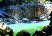
And the rivers flow here slowly and majestically. The largest and most majestic, of course, is the Danube (about 600 km across Serbian territory). The Danube has a lot of oxbows, bays, bays and swamps. In addition - the famous Djerdap gorge. Most of the border between Serbia and Romania runs along the river.

Although fishing is thriving on the Danube, the river is considered rather muddy by international standards. However, what can we say about the Volga or Kama !? The largest Danube tributary, the Sava, flows from the west, from Croatia and Slovenia, and very beautifully flows into the Danube right in Belgrade.
Many rivers are navigable. Game has survived in the forests, and hunting and related tourism flourish. There are many wild fruit trees such as plum and apple trees. And don't forget the mountains to the west and north, with pine forests and the cleanest air. There are as many as 5 national parks in Serbia!

Serbia climate continental and does not differ in softness. Especially in Vojvodina (Novi Sad). True, there are practically no severe frosts in winter and snow usually lies only in January and February. In the mountains (for example, in Zlatibor or Kopaonik), snow lies from November to April.
The main problem in Serbia is the wind. Cold "koshava" blowing from the east from October to April, with varying success, brings either rains or a blizzard. There is not much good in this. In Vojvodina, the "Severatz" comes out, blowing naturally from the north from Hungary. However, all this can be experienced. Is not it?

The Mediterranean climate in Serbia is not observed, due to the fact that the mountains interfere with the southern air masses. Moreover, sometimes the temperature in winter drops even below 20 degrees.
The main part of the country is located on the Balkan Peninsula. The geography of Serbia is characterized by mountainous landscapes. There are four mountain systems... The northern part, meanwhile, is represented by plains.
The mountains of Serbia are quite high, fifteen of them are two thousand meters high. Jaravitsa reaches two thousand six hundred meters. The republic has a number of navigable rivers such as the Sava, Tisza, Begei, and the Danube. The country has built canals connecting the main waterways. Numerous lakes, if they do not replace the seascape, are still wonderful place for relax. Vlasinskoe and Radonichenskoe lakes have a very picturesque view. Serbia has large waterfalls that originate in the mountains. Jelovarnik and Piel are over sixty meters high. Geography of Serbia differs in constancy and attracts with abrupt transitions from plains to mountain ranges, from waterfalls to lakes.
Serbia Time
It differs from Moscow by one hour. The country is annually transitioning to winter and summer regimes. The first time the clock is set on the last Sunday in March, and the second time on the last Sunday in October.

Serbia climate
The Balkan Peninsula is surrounded by three large seas. And, despite the fact that the country has no access to them, it directly depends on the offshoots. The presence of mountain systems also plays an important role. The country has three climatic zones: continental, moderate continental and mountainous. The first covers the territory of the north of Serbia, the second - the south, and the third covers the mountainous regions.
Serbia subject to winds, each of which has its own name. It rains most often in May or June. Summer in the country is invariably warm and well suited for relaxation. In winter, there is a lot of snow in the mountainous areas, which is very good for ski trails and attracting travelers to the country. Serbia Tourism develops and promises to reach the world level over time.

Serbia weather
The warmest month is July. The average temperature is thirty degrees with a plus sign. During snowy and cold winters, the thermometer drops to twenty degrees. Serbia weather pleases with fast springs and long warm autumn. Numerous tourists visit the country's mountain trails in winter for active recreation.

Serbia nature
In the flat part of Serbia, you can see the steppes, and in the mountainous regions there are mixed forests. The foothills are overgrown with oak forests, and beeches and firs settled a little higher. In addition to these trees, you can find spruce, ash, maple, chestnut and much more. Plum orchards and vineyards are cultivated in agricultural areas. The nature of Serbia is rich not only in vegetation, but also in animals. Largely the reason for this geography region.
The forest inhabitants are traditionally deer and roe deer. On the plain, wild boars and hares are at ease. White and black storks share the sky with birds of prey such as eagles and kites. The rivers are full of commercial fish. Cattle were introduced into the country as well as goats and sheep. At present, the government of the country takes care of the conservation of wild animals, arranging protected areas for them.
👁 Before you start ... where to book a hotel? In the world, not only Booking exists (🙈 we pay for a high percentage of hotels!). I have been using Rumguru for a long time
skyscanner
👁 And finally, the main thing. How to go on a trip without bothering? The answer is in the search form below! Purchase. This is such a thing that includes flights, accommodation, meals and a bunch of other goodies for good money 💰💰 Form - below !.
Really best hotel rates
Flora of Serbia is represented by such plant species as coniferous, mixed and deciduous forests. Also present are such tree species as maple, ash, chestnut, walnut, willow and poplar.
Roe deer, wild boars, bears, chamois and hares are typical representatives of the fauna of Serbia.
The avifauna is represented by kites, eagles, black and white storks, partridges, pheasants and other representatives.
Catfish, carp, perch, carp and trout are found in local rivers.
👁 Do we book the hotel as always on the booking? In the world, not only Booking exists (🙈 we pay for a high percentage of hotels!). I have been using Rumguru for a long time, it is really more profitable than 💰💰 Booking.
👁 And for tickets - to air sales, as an option. It has been known about him for a long time 🐷. But there is a better search engine - skyscanner - there are more flights, prices are lower! 🔥🔥.
👁 And finally, the main thing. How to go on a trip without bothering? Purchase. This is such a thing that includes flights, accommodation, meals and a bunch of other goodies for good money 💰💰.
Serbia in terms of area (88,361 sq. Km.) Ranks 113th in the world. In the north, Serbia borders with Hungary, in the northeast with Romania, in the east with Bulgaria, in the south with the former Yugoslav Macedonia, in the southwest with Albania and Montenegro, in the west with Croatia and Bosnia and Herzegovina. The length of its borders is 2,027 km (with Romania 476 km, with Bulgaria 318 km, with Macedonia 221 km, with Montenegro 203 km, with Albania 115 km, with Bosnia and Herzegovina 302 km, with Croatia 241 km, with Hungary 151 km). There are 6,167 registered settlements in Serbia, of which 207 are urban. Arable land occupies 19.194 km2, forests - 19.499 km2 (without Kosovo).
Extreme points - North: 46 ° 11` N. (near Hajdukovo), South: 41 ° 52` N (near Dragash in Kosovo), East: 23 ° 01` E (Senokos, near Dimitrovgrad), Western: 18 ° 51'E (near Bezdan in Vojvodina). 80 percent of Serbia is located on the Balkan Peninsula, 20 percent is the Pannonian Lowland. The length of the borders is 2,027 km (with Romania - 476 km, with Bulgaria - 318 km, with Macedonia - 221 km, with Montenegro - 203 km, with Albania - 115 km, with Bosnia and Herzegovina - 302 km, with Croatia - 241 km , with Hungary - 151 km).
Plains prevail in the north of Serbia. 15 mountains in Serbia are over 2,000 meters above sea level. There are 4 mountain systems in Serbia. The Dinaric Highlands covers a large area in the west, stretching from northwest to southeast. Stara Planina and the East Serbian Mountains are in the east, separated from the Dinaric Highlands by the Morava River. In the south, there are ancient mountains - part of the Rila-Rhodope system. The highest point in Serbia is Mount Jeravica (2656 meters)
Relief of Serbia
The relief of Serbia is varied. Vojvodina has fertile plains. In the southeast, there are ancient mountains. Central Serbia is dominated by hills and low mountains.
Mountains occupy most of Central Serbia and Kosovo. There are 4 mountain systems in Serbia. The Dinaric Highlands covers a large area in the west, stretching from northwest to southeast. Stara Planina and the East Serbian Mountains are in the east, separated from the Dinaric Highlands by the Morava River. In the south, there are ancient mountains - part of the Rila-Rhodope system. The highest point in Serbia is Mount Jeravica (2656 m)
Inland waters of Serbia
Most of Serbia (81.646 km2, 92.4%) belongs to the Danube basin, which in Serbia is 588 km long. 5% - to the pool Adriatic sea, 3% - to the Aegean Sea basin. The length of the Danube in Serbia is 588 km; the border with Romania and Croatia runs along it. The main tributaries of the Danube in Serbia are Tisza (flows from the north), Sava (from the west), Drina (from the south, the natural border with Bosnia and Herzegovina), Morava (from the south, completely in Serbia).
Serbia statistics
(as of 2012)
In addition to the Danube, navigable rivers are Sava (206 km), Tisza (168 km), Begei (75 km), partly navigable - Velika Morava (3 km out of 185 km) and Tamish (3 km out of 101 km). Other major rivers are West Morava (308 km), South Morava (295 km), Ibar (272 km), Drina (220 km) and Timok (202 km). Part of southern Serbia belongs to the basin of the Beli Dream and Radik rivers (4.771 km, 5.4%), which flow into the Adriatic. Basins of the Pchinya rivers. Lepenac and Dragovishtitsa belong to the Aegean Sea basin. Serbia also has a number of artificial canals that are used for flood protection, irrigation, etc. Their total length is 939.2 km, of which 385.9 km are used for navigation of vessels with a tonnage of up to 1000 tons. The largest canal system is the Danube-Tisza-Danube. The largest lake in Serbia is Lake Djerdap. The largest natural lake - White lake... Most big Island Serbia is located on the Danube near Kostolc. There are also waterfalls in Serbia, the largest is Jelovarnik (71 meters), it is located in the Kopaonik National Park.
The abundance of relatively unpolluted surface waters and many sources of underground natural mineral waters enables export and economic development... However, the widespread use and production of bottled water began only recently. Serbia has great geothermal potential.
Natural lakes in Serbia are small and rare. Most of them are located in Vojvodina. But there are many reservoirs in Serbia. The largest of them are Djerdap on the Danube, Perucac on the Drina.
Serbia climate
In Serbia - moderate continental, on the Adriatic coast - Mediterranean. In the central regions of the country it is always somewhat cooler than on the coast, and the influence of subalpine factors is more noticeable. In the seaside region, summers are usually long, hot (+ 23-25 \u200b\u200bC) and rather dry, winters are short and cool (+ 3-7 C). In mountainous regions, the summer is moderately warm (+ 19-25 C) and relatively cold (from +5 to -10 C), abundant in snow, winter. Precipitation falls from 500 to 1500 mm per year, mainly in the form of rain, in the mountains near the sea coast in some places it falls over 3000 mm.
The best time to visit the country is from May to September-October. Tourist season usually starts in April and lasts until November. The sea temperature for seven months ranges from +20 C to +26 C, so the swimming season is equal in duration to the tourist one.
Serbia is on the Balkan Peninsula surrounded by warm seas - Adriatic, Aegean and Black. North of Serbia is the European continent. Another important factor that determines the Serbian climate is relief. Serbia is dominated by a continental climate in the north, a temperate continental climate in the south and a mountainous climate in the mountainous regions. Winters in Serbia are short, cold and snowy, summers are warm. The coldest month is January, the warmest is July. The average temperature is 10.9 ° C. The average annual precipitation is 896 mm. Most of the rain falls in June and May.
The strongest winds are: Koshava (cold and dry wind in the north of the country), Severac (cold and dry north wind), Moravac (cold and dry north wind blowing in the Morava valley), South wind (warm and dry south wind blowing in the Morava valley). Southwestern wind (warm and humid, blowing from the Adriatic, mainly in the West of Serbia).
Flora and fauna of Serbia
Very rich in plant and animal world... Four-fifths of the forest area is deciduous and one-fifth is coniferous forests. Serbia is inhabited by bears, wild boars, wolves, foxes, hares, wild goats, fallow deer, mouflons, lynxes, deer, martens, chamois ... bird world: Of the 666 bird species found in Europe, 508 species live in Serbia, including eagles, falcons, pheasants, partridges, wild ducks, marsh snipe and other wading birds. Rivers, lakes, canals, ponds abound in different types of fish: carp, pike perch, sturgeon, catfish, sterlet, pike, trout, mackerel ...
Serbia population
Population - 7.82 million people (in 2008) (in 1991 - 9.79 million people); including: in Central Serbia - 5.82 million, in Vojvodina - 2 million. 52% of the population lives in cities.
During the disintegration of Yugoslavia in 1991-1995, several hundred thousand refugees from Croatia and Bosnia and Herzegovina arrived in Serbia. In 1999, there was a large wave of emigration of Albanians from Kosovo, and in 2000-2001 - the emigration of Kosovo Serbs. The population is dominated by Serbs (62 percent) and Albanians (17 percent). Serbia is also home to Montenegrins (5 percent), Hungarians (3 percent) and a number of national minorities. Before the outbreak of hostilities in 1999, Serbs constituted 85 percent of the population of Serbia proper, 54 percent in Vojvodina and 13 percent in Kosovo; Hungarians and Croats are numerous minorities in Vojvodina.
The official language of the country is Serbian. In Vojvodina, Hungarian, Slovak, Croatian, Romanian, Ukrainian and Ruthenian languages \u200b\u200bare also spoken. In Kosovo and Metohija, the official ones are Serbian and Albanian.
According to the 2002 census, without Kosovo: Orthodox Christians - 6,371,584 people. (85.0% of the population), Catholics - 410 976 people. (5.5% of the population), Muslims - 239 658 people. (3.2%), Protestants - 80,837 people. (1.1% of the population). Jehovah's Witnesses - 3,871 (0.05% of the population) as of 2009
Source - http://ru.wikipedia.org/
The Republic of Serbia borders on Macedonia in the south, Bulgaria and Romania in the east, Hungary in the north, Croatia and Bosnia and Herzegovina in the west, and Montenegro and Albania in the south-west.
Serbia is divided into two autonomous regions: Vojvodina and Kosovo.
The territory of the Autonomous Province of Kosovo and Metohija is controlled by the partially recognized Republic of Kosovo. (See Kosovo)
On February 17, 2008, unilaterally with the support of the United States and a number of other countries, the Albanian authorities formed in Kosovo unilaterally declared independence from Serbia, which was recognized by 69 UN member states. Russia, China, Serbia and others refused to recognize the sovereignty of Kosovo.
80% of Serbia's territory is located on the Balkan Peninsula, 20% is occupied by the Pannonian Lowland.
The Republic of Serbia (Serbian Republic of Srbiјa) is landlocked.
Energy supplies to Southern Europe are carried out through Vojvodina, and only through Vojvodina is through navigation possible on the Danube and the Tisza-Danube Canal.
Plains prevail in the north of Serbia. The further south the country is, the larger the mountains become.
Near the town of Pancevo, on an area of \u200b\u200b30 thousand hectares, Deliblat lies - the only sandy desert in Europe.
The icy lake on Fruska Gora arose during the 1999 NATO bombings, when the pumps of an abandoned quarry stopped pumping water and it filled the quarry. The lake with cold green water is surrounded by cliffs, but access to it has been prohibited since 2006 due to frequent landslides.
Djerdap is a gorge cut by the Danube with a length of 100 km, the height of the rocks in it is up to 800 m, the width of the Danube in this section is 147 m, the depth is 77 m.
In the region of Djerdap, there are the remains of an old Roman road, built by order of the Emperor Trajan in the 2nd century.
According to legend, Emperor Trajan broke through the Djerdap Gorge and, in his pursuit of gold in the Peck River, dried up the ancient Pannonian Sea.
In the Djerdap region, the Danube divides neighboring Romania with Serbia. The narrowed (150 m) channel of the Danube is called the Porţile de Fier (Iron Gate), which is associated with a huge hydroelectric power station built back in the 70s with the participation of the USSR, when the water level that rose sharply behind the dam (by 18 meters!) Flooded dozens of Danube villages in Yugoslavia and Romania.
The Danube at the Iron Gate is 90 meters deep, making it the deepest river in Europe.
The width of the Danube in the Belgrade region reaches a kilometer.
Kopaonik is the longest mountain range in Serbia, 120 km long and 50 km wide. There are a large number of thermal springs in the Kopaonik mountains (36 - 78 ° C). In the territory national park located highest waterfall Serbia Jelovarnik (71 m).
The Mlava River in eastern Serbia is famous for its dark green water.
Cicevac (10 km from Krusevac) is full of ponds, swamps and backwaters. Chichevac is famous for the Great Whirlpool, which is connected to the Morava River by a network of underground canals. The locals call him Crazy and say that he is bottomless.
The accumulation of bizarre earthen figures in the vicinity of Kursumlija, which nature creates and destroys by erosion, is called the "city of the devil". Javolya-Varosh (Devil's city) occupies 70 hectares.
Tara is a mountain in western Serbia, with flowering meadows and coniferous forests, in which trees of the relict species of red spruce, that is, Serbian spruce (Pancicheva omorika, Picea omorica), discovered by the biologist Pancic, grow.
In Serbia, in the vicinity of Bora, there are about 1000 caves, a small number of caves have been explored. Lazareva Cave near Bora is the longest in Serbia.
The southeastern part of Serbia is also home to the most deep cave - Pit on Dubashnitsa, 276 meters deep below ground level.
The entrance to the famous Resava cave is located in the depths of the Belyanitsa mountain, about 10 km west of Manasia. It was discovered only in 1962, because the vegetation hid it from the eyes of people. The cave has three levels and a total length of 2380 meters. An underground river flows at the lowest level.
In the sediments of two dozen caves in Serbia in the east of the Kosovo Basin, the fossil remains of fifty-five species of mammals were discovered, including lions, hyenas, mammoths, and bison, which migrated due to a sharp change in climate.
Ten species of centipedes and two species of zooplankton were discovered in Lazareva Cave. This cave is home to twenty-three species of bats out of twenty-seven found on the European continent.
Djerdap Gorge (on the border with Romania) - the largest gorge in Europe, it consists of four gorges and three basins. The most beautiful gorge is the Big Kazan, whose vertical sides rise up to 300 m above the Danube, and numerous whirlpools go down to 90 m in depth.
The highest mountain in Vojvodina is Mount Vrsac (641 m) in the southeast of Vojvodina.
The highest railway bridge Balkan is located in Kolasin, on the Belgrade - Bar line, the height of the overpass is 198 m.
The koshava wind carries cold air masses from the Iron Gate of the Danube to the Pannonian Plain at a speed of 60 km / h. Serbs say that "Koshava" blows for three days; if it does not stop, then a week; if it does not subside even then, it will rage for two weeks.
There are 300 types of mineral waters known in Serbia, 260 of which are actively used in the treatment of various diseases.
Serbia has over 1000 medical mineral springs... Remains of Roman baths testify to the first resorts in Serbia.
Resorts of Serbia: the oldest sulfurous Banja Koviljaca, the mineral Selters bath on Mount Kosmai, the therapeutic and mineral bath for diabetes Vrnjachka Banya, Soko Banya, Atomska Banya, Nishka Banya, etc.
At the foot of Mount Guchevo (779 m above sea level), on the banks of the Drina River, there is the Banja-Kovilyacha bathing resort, which is famous for its waters containing sulfur (19-28 degrees centigrade), iron (14-15 degrees centigrade) and radioactive waters (5, 9-6, 8 IE). The mud of the Banja-Koviljaca resort with sulfur content is kept for 2-3 years and then used for medical procedures.
This resort owes its name "Prolom Banya" to the rare, but powerful hurricanes that passed in these places and left only devastated land behind.
George Weifert in 1903 became the owner of the largest copper mine in Europe. The Mining and Metallurgy Museum in Bor has over 15,000 exhibits.
A new mineral, sodium lithium boron silicate hydroxide, is similar in composition to the fantastic mineral Kryptonite, which takes Superman's power. Kryptonite was discovered in one of the mines in Serbia.
Kopački-Rit is the remains of the ancient Pannonian Sea. After it dried up and disappeared, a swampy zone remained here at the confluence of the Drava with the Danube, fourteen kilometers north of the city of Osijek. In spring, when the snow melts and the water level rises in the rivers of the middle Danube, an average of about 30,000 birds gather here. Late autumnwhen the water subsides, huge masses of fish are set in motion.
Fruska Gora - a former island of the Pannonian Sea, and now National park with an area of \u200b\u200b500 sq.m. The most high peak - Red Chot (height 539 m above sea level).
Fruska Gora Park has one of the largest linden forests in Europe.
Zlatibor - mountain range south of Belgrade, plateau height 1000 m above sea level, 309 km from the Adriatic coast. Here grows the only species of conifers in the world, which have a special golden shade of the trunk.
Oaks grow on Zlatibor, which, according to scientists, cannot grow above six hundred meters above sea level.
Zlatibor is the only place in Serbia where the Mediterranean and Alpine climate mixes. It is sunny in Zlatibor, like on the sea coasts, and fresh, like in the Alpine mountains.
The territories near the cities of Presevo, Buyanovic, Vranje, and the Lustica Peninsula were contaminated with radiation in 1999, when NATO troops fired more than 50 thousand shells of depleted uranium at targets in Yugoslavia.
There are jackals on the Pelješac peninsula, the islands of Korcula and Mljet; the mongooses brought here live on Mljet.
In Obedska Bharu, entire colonies are formed by herons of all kinds: gray, small white, red, yellow and night heron.
In the mountainous regions of Bosnia, Herzegovina, Montenegro and Serbia, about 60 species of snails have survived.
On the eastern slopes along the Danube in the town of Strazhilovo, near Sremské Karlovci in the 3rd century AD. Roman Emperor Probus planted the first vineyards.
In Negotinskaya Krayne, about 1000 hectares are occupied by vineyards. Here grow varieties such as Bagrinya, Zatsinak, Prokupats, Vranats and Smederevka. Negotinska is known for its tamyanik variety.
Dositej Obradovic brought potatoes to Serbia for the first time in 1811.
Serbia is the world's largest exporter of raspberries. One third of all raspberries in the world are grown in Serbia. 95% of the best raspberries are harvested in Serbia.