place about. Sakhalin, Peninsula Krölon
time September-October 2013
First day: again south
In mid-September (2013), free days were issued: a hitch with orders, and nothing else was planned anymore. Everything, now I am exactly going to Cape Krylon! But Maxim persuaded to go to the thousandrd (1) of southern Sakhalin - Spamberg Mountain. Maxim just fell out of vacation, and it was necessary for him somehow with the benefit of spending time. I had to meet the expensive friend.
Let's go to the spamberg mountain. In the foothills and on the slopes of this mountain, four days were fired. Reached only the high mountain lake Mokhovo. They smashed the camp. The next day began to storm the top, but met the fierce resistance of the bamboo, and when a cedar stabeth came to the help with a bamboo with a sudden rain, we were capitulated. They were content with only the fact that they contemplated the vertex from the two-kilometer distance. But, by returning to the camp, we rode on someone once a long-long raft and comprehended the beauty of the lake Mokhovo (clouds over the head!).
Returned to the city on Friday. I was enough for a day and a half, and on Sunday I again put up on the journey. Now, for sure to Krylon! This time nothing kept: the fact is that, returning from the spamberg mountain, I contacted the next employer and found out that while I was swinging at the heights of southern Sakhalin, they were unsuccessfully tried to go to me so that I had a hurried order to arrive at them And put a signature in the short-term contract. Naturally, I was out of connection, and thus lost an order for a considerable amount of money. It was a reason to be upset, but, remembering that before sending to the mountain Spamberg, about the campaign on which I agreed in advance with Maxim, I had already had to refuse a sudden customer who had fallen, I realized that I am dealing with the system (2), and calmed down . This system of cunning is arranged: either you spin in it, getting consistently money, food and entertainment, and at the same time you are a dependent screw, an instrument and an executor of someone else's will; Either you are outside it, but at the same time we are chaotic, unstable, but, most importantly, a free lifestyle, and your life is full of unpredictability, interesting people and beautiful landscapes. In general, the blind system wants one of you: so that you can sit on the spot and waited for instructions, regulations and teams from it. The system is stupid, and there are ways to get around it. However, it has to sacrifice profit and comfort. What I felt on my own experience.
Since so, then walk, so walking: hastily gathered a backpack, I left 14.20 hours on the flight bus to Aniva. Outside the city I was stuck in a jeep (after all, the hitchhiking is a funny occupation!), And the driver Dima brought me to the village of Taranai, in terms of painting the advantages of kiting, which he fucked. Behind the village of the case with the hitchhiking went no matter: no one picked up. Thus, from the very taranny to Cape Krönon, I went on foot.
Having passed on the road a couple of kilometers, I decided to go to the shore of the sea, for the road walked farthes. I walked to the south, contemplating far forward by the peninsula Krölon and the illusory islands of the Tonino Aniva Peninsula, which shines on the other side of the aniva bay. By this, the pre-coast, I also walked south a month ago. The extreme points of Sakhalin, according to the Sakhalin scientist and traveler Andrei Clitin, will attract us to themselves, as the once ancient hunters have attracted, seeking to reach the edge of the Earth. I caught myself thinking that I was going for happiness. As far as this is true, I find out, at the end of the way, and while I feel the earthly happiness to go away with a backpack behind your back.
In general, the concept of an autonomous existence of a person was held by a long time ago: a tent, a sleeping bag, a sleeping rug, a necessary stock of products, matches, a gas burner with a gas cylinder (a new item in my hiking set; I bought it inexpensively in the store "Amateur"; in general in the specified The store has everything for travel, I recommend!), a headlamp flashlight, removable clothes - all this makes it possible to move in space and weighs only 12 - 15 kg. Of course, such a lifestyle implies certain inconveniences and quickly comes, but, nevertheless, romance provides the opportunity to truly "take everything from life."
Aniva Bay ... Beautiful, long-suffering, poisoned by Rygami (3) and other disgust. Driving away from themselves these asleep thoughts, try to think about positive. Still, Sakhalin is a unique place: wherever you are, he will be different everywhere. Sopgia and Tundra, Taiga and Mountains, Bay and Waterfalls - and all on one island!
I am going along the coast of the jeeps and passenger cars, resting people who start in the sea a network of fishermen playing in the sand of children wearing dogs, etc. Shores Zamuoroz. I hurry to go through the human bustle. I am dying. The guinea of \u200b\u200btwenty-five years old, the collective farm-tailed species is politely interested in my person. We speak. Participation admires my campaign. He lick his hand on farewell. Having passed a few hundred meters, I hear the shore: from an inflatable boat near the shore, the fisherman offers fish.
Is free! - he adds.
I refuse a smile, referring to the absence of a place in a backpack.
Dusk gradually thickened. You need to break the camp. Pleases the abundance of wood thrown ashore. Stay at a full-water river, a little at least to Cyrilova. Singing a tent, laying a fire. River - fishing mill. From there in my direction two bodies are sent in orange fishing jackets. One of them approaching the edge of the river water, shouts to me "Hey!" And waves with hand. I fell.
If you see that the network is set, ...! - the unconcernly threatening tirade is distributed.
What makes you think that I will put the network?! - I reply to him.
The elder is already a man gives positions and adds notes apologize to his speech:
You apologize, of course, that such a tone, but here recently two stayed. I look in the morning, the network was put and you caught two things. And here we have RUZ (4) stands, waiting for fish.
I decide to change the topic:
Water in drinking river?
And I ask a new question for the affirmative answer:
Sugar tomorrow in the morning give, and then in a hurry at home I forgot to take?
The fisherman turned out to be sureless.
Another most accustomed feature of this area was the presence of evil mosquitoes. A strange thing, in the taiga on the slopes of the spamberg mountain they were not, and here they insistently attack them! What an anomaly?! Autumn, cold already, it's time to sleep to them. No, active as in summer!
... and a newly tested on the opposite shore of the Nevelsky Strait, the village of Lazarev, the feeling, when sitting in the evening at the tent, I looked at my native Sakhalin shore and wondered if the sea calms down to calm down to be able to move through the strait. This feeling is a feeling of loneliness, left and at the same time this is awareness that you do not need anyone, except for loved ones who are not near, but which you love and wait.
Because of the mountains of the opposite shore, in the area of \u200b\u200bthe suburban and mountain of Junon, that on the side of the aniva bay, an orange flawed moon was floating. Circle Beauty: the lights of that coast, bright stars in the sky, the Milky Way ... Firewood Fun Fry. The Caean Firewood of the Spamberg Mountains did not really want to burn, and these directly rejoice in life.
I am made up.
Day Two: Full Freedom, Sea Tides and Assistance of legendar around the name of the Cartaw
Put at 6.50. Very cold. From three o'clock in the morning it did not sleep: the body was leaned from the cold. At dawn, however, it became more fun in the sense that contemplated the paint of life: mountains, bay, lights of ships and settlements, all this is in the rays of dawn. Firewood here and really gracious: flare out in a man, giving the joy of heat
Crossing the Rod River, I go to the mill. Fishermen are sitting on Zawalinka, among them - my yesterday's interlocutor. As promised, he gave sugar, even with interest - she would definitely pull on the shelf. Fishermen around me are animated: I brought into their monotonous reality (for all day to expect fishing fish!) Fresh air flow. As usual, they pound a bunch of tips on the road.
I go along the brilliant sun shore. "Absolute freedom!" - Sang, it is remembered, Romych is irrelevant from the Siberian "Survival Instructions". Here it is, full freedom! With everything, this is not just aimless tental world, but scientific travels. This definition brought the ideologue of Anton Krotov. After all, the journey - whether by passing, whether the hitchhiker, Lee hydrostop, is the aviastop, whether on the bike, on Kayak Lee is always expanding the horizons of knowledge. These are new lands, new people, and new impressions, and most importantly - new knowledge. With this position, the hitchhiking - and any any trip - good in the period from 18 to 30 years. The basis in the head and soul lays the capital! And, of course, invaluable life experience.
I come to the liquidated village of Kirillovo. Here, until recently, there was a border search, cordon, which controlled the territory of the reserve (Peninsula Krölon - Reserve). In 2005 or 2006, it was disbanded, and jeeps and other quad bikes were jeailed here, and now there is a passage yard.
I am welcomed by a rusty all-terrain vehicle, or, it is better to say, his framework. Monument to the past of the Soviet Army. In the distance lonely rushes observation tower.
There is nothing to guard, Sakhalin is now the zone of the free framing of world refrain, Lychimens and Baryg. Well, you can do, it is postmodern (5), the epoch when the world is ruled by petrodollar trades, telecons and fitlights. No state ideology; Instead of love for the Motherland, cheap pseudo-patriotism and the desire to dump abroad, for it is comfortable. How much I saw the disbanded and looted troops in Russia! It is not possible to quietly.
I turn the ving river Uryum. In general, the rivers of the Eastern Coast of Cruralon are full-flow. About this below.
Wit to the mill. Dog barks. It turns out a high, who has grown up with a beard of a man of fifty years. I asked him bread. He gave crushers - also well, even better: do not moldy. My new acquaintance is Vadim. He is from Krasnoyarsk. I came here on my car on Putin, but the fish this year was very small, and now he sadly prevents how much money he needs to return home. Bored, says, in his little granddaughter. It turns out, Vadim is a trucker, the whole country has been traveled! You look, even here, on the shores of the distant Russian island, far from the federal routes, discovered an eternal union-symbiosis friendship of motorways and truckers. For a piece of Vadim with a dog spent me a little.
I pass an interesting coast. Hidden, it consists of petrified sand (as it seemed to me, although I am not a geologist). In one place, this slope "paid" the head of some mutant. Miracles, and only!
Here I am satisfied with dinner: on the gas burner heating a canned pearl porridge.
I go to the Maximovka River. Here is a big mill. A man was released, so for fifty, in the leather jacket, alcoholic (there are such people whose elegance is supported in any conditions). Introduced himself by Sasha. He will catch the mill to spring. So it has been working for several years. He says, he likes it here, and when is at home, in Chekhov, he pulls him here. It's especially good in winter, he adds.
Not far from him another mill. His boy is guarded by his boyfriend. Go to visit each other.
And recently I go in the evening from him to myself. Dark, candle with a flashlight. I see - the bear follows me, I shouted, and drove it, and he walked everything for me to the house until the thicket turned.
Sasha drank me and fed with huge, delicious Oladias prepared by them based on coffee powder. Gave on the road of superstars, pancakes and ointment against mosquitoes. In general, I once again concluded that the abyss in our missing world will not be given to you: feed, we will seek and on the road of everything they nad (6).
So far, Sasha told that this year Putin was not. Personally, he earned on fishery in an anison of everything ... 650 rubles (!) For the whole season. I make an assumption about myself that one of the main reasons for a meager ride of fish is to overlap by Ruzami Sakhalin Rivers in previous years.
Sasha accompanied me along with a young playful cat sima.
She, like a dog, walks with me along the coast.
Nearby river Ulyanovka flows. From this place, my incessant struggle with the elements and metaphysical adventures on this initial peninsula began.
The river itself is not small, and then the tide of the sea began. Waves straight into the river enter. There was a breakdown, and immediately realized that the depth was not children. Slightly above the course - Japanese Bridge; I thought it would go on it, but he turned out to be destroyed. The exit from the situation found the following: With the help of the pole, the braid was spoiled by the sea, where it was possible to switch to the belt in the water, and, to break the Bag (7) on the shoulders, moved to the other side.
The sun, leaning towards the West, has rolled out for the high shore. Tide presses. I go on the stones - a strip of small boulders began. There is a broken TV.
Original: In the deaf places such an echo of civilization. Yes, even with a broken screen. Apparently, the fishermen were sitting (or bears?) We looked-watched and, not sterme scratching, that it was going on on the screen, broke it with stones and left the ravis. Imagination in such places works well. ABOUT! But the refrigerator. On the west coast of the Tonino Aniva Peninsula a month ago, I pretty met them; Now watch, and here come across!
Before each new cape, I go with a fading heart: something will open something behind him? ..
Again, Brod - River Kura. I turn this river on the throat in the water with a Bag's head - it is so deep. However, this is a tide, you can probably go to the tide and in the belt to pass it.
I went out on the spit. In meters of three hundred - fishing mill. The guy who met me, said that a little further - Uncle Sasha and Oleg Cartaw. Cartvy?! Ba, familiar surname!
And here, having passed two kilometers - just the beginning began to try out - I see: the mill is not met, and some arbor, houses, etc. At the mouth of the river (R.Colchozya), in an artificial dam lie the broken carcasses of Nerge, which I immediately did not like. Near the jeep. Fixed two.
Are you going to south? Come in sleep. There you will reach the maximum to Medvedevka, and that's it. So it's better to have a night, "says a brisk man, says me.
Yeah, here he is the son of the famous Father. However, the availability of Tsush Nerp does not allow me to fully trust these hospitable people:
I've seen I saw here, you will not be poachers?
The man slightly changed in his face, but, looking into my eyes, I found a suitable and tidy answer:
No, we are just a travelers, we separate and instress. - And, seeing my calm, added with the delusted addiction, - what are we to you poachers?! The reserve here, everything legally. I myself would shoot these poachers. Come in, do you need. Now we will dine.
Oleg Cartawa - St. Justice, as he has not recommended; The son of Fedor Leontievich Cartawa is the famous Okovenna, Senior Hengery of Krönon, who in his time he oversaw the peninsula. His grave is located on the Nachi River. In the same place, his wife was buried next to him. I read about Fedor Leontyevich in the story of one Sakhalin writer shortly before the campaign.
After Bati, no one did not become. And when in 2006, I was removed in Kirillovo, then at all came on Anarchy Crylon, "Oleg stated the sad fact.
This border shop seems to not so much protected the frontier from spies, saboteurs and a foreign invasion, as from our local barbarians.
Here the border guard is sitting, sees you are walking: I wanted - let you, did not want it - I sent it.
For dinner, Oleg told a lot of interesting things about his father. Fedor Leontievich, it turns out that she also became famous for eliminated on the peninsula of a huge bear-cannibal, who devoured himself like. According to Oleg, who heard all this from his parent, this monstrous bear chose a place where the river makes a turn: climbed over the three-meter breakdown and just lying, waiting for the victim. Heads the steps on the water and jumps in front of the stolen bear. Falls it, hides a carcass and further lies. Heads again the topot on the water, jump - and there is no worsted relative.
And this is somehow this bear-cannibal in his ambush, "says Oleg," hears: steps. Jump with a cliff, and before him is not a bear, but ... Fedor Leontievich.
Oleg with a sense of natural pride for his father continues:
Truck of this giant in the rolled form weighed 520 kg! At the VDHH, his skull was first place. And when they wanted to send to Europe (European competition), a snag was released: our intelligence swallowed that the skull of the trophy bear Ceausescu (8) was less. It was decided not to humiliate Ceausescu, - a trophy of some Fedor Leontievich, see whether, more than Trophy Chausheck! - And thus not spoil relations with Romania, and Batin Bear has not been exhibited to Europe. This is all the policy that it was empty!
Next to me at the table was sitting partner Oleg Sanya. Dared to soup and pelengas.
Eat everything, we have already founded during this time.
When a bear-cannibal was filled, he found five-six-six bear killed by him, "Oleg told Boyko in the continuation of the topic.
I do not like when they boast, he developed the thought - that, they say, the bear was killed with three hundred meters, etc. It would be tried closely as Fedor Leontievich, dealing with bears to have.
I thought even further: that our ancestors went to the bear with Rhotina and often won in an honest match. Now the hunting prow is lowered their bar as small arms improve. Everything is relative.
And you are not afraid of you go alone among the bears? - with a small fraction of irony looks at me by St. John's wort.
Yes, somehow there is no fear, the thing is habitual, - I answer the calm.
You have attacked a bear at least once. Not? But I was attacked ... you would speak differently.
It seems that the bear is a calm creature. I even heard that he was afraid of man. Just need to not provoke it ...
The gun spoon, Oleg grinned, throwing a look at me:
And who knows him that he has in his mind. Here we sit here with you, eat, and you suddenly take a knife and you will quit us all. Who knows you?! So and the bear.
Sitting in a gazebo against the background of the twilight bay and distant high shores, talked with Oleg and for life.
The wife needs to choose to yourself so that it was younger than eight years: that is, for example, you are forty years old, and she ... somewhere thirty two. Well, so that she has already grabbed in full in this life, would be offended from men and did not twitch more.
I strongly disagree with these views.
However, to give advice on life - the case is ungrateful, to each his own, - cheerfully summed up Oleg.
Come to this general conclusion, sleeping in a thickening darkness.
Judging by the words of Oleg Cartvy, from the barrier, the village of Kirillovo to his mill - 27 kilometers. Thus, in the day I made about 30 km.
Day Three: Based fishing rays, Sakhalin jungle and Cape Anastasia
We woke up at seven in the morning from the assertive and loud:
Sanya! Get up!
This Oleg woke his partner (I spent the night in the Sani house).
Get up-get up! It is necessary to collect things.
Today they turn and leave the mill. Before noon, when the tide begins, it is necessary to have time to collect Skarb and disassemble the houses and slip on the sump to the north. Tide at twelve begins. What is tides, especially in the mouth of the rivers, we already know.
The sky frowned. However, the forecast promised: the rain on Tuesday in the morning.
Fedor Leontyevich's motto was: "You can not do - do not promise, swung - Bay."
In such a parting word, Oleg with Sanya spent me on the road. Oleg gave me her mobile number.
I went out at 8.30 in the morning. Skipped rain. After a while, it became more insistent after some time, and the capital rain began, overnightly moved me to the thread.
Soon the buildings appeared - this is, after going about 8 km, I went to the shores of the Nachi River (it was there that the grave Fl. Martawn and his wife). On the north bank of the river - Stan. As I was told the day before, someone petrovich lives here.
The camp is huge. Knock on the door. He left the church small named Sergey. Petrovich himself was in the trailer. After some time, we have already had breakfast three. Petrovich is a bearded spotted, strong internally elderly man living in these territories since 1989. On the east coast of Krylon everyone knows him. In turn, he was personally familiar with F.L. Martaws.
Having treat me with a smoked duck with rice, Petrovich told about how two English women were overwhelmed on this floor, who sailed to Japan on the canoe. I immediately found out: Rather, one of them was Sarah Outen. She walked into the army and moved through Sakhalin to Japan: just from Krylon to vaccine through the strait of the lapere. I then worked in the authorities and dealt with this issue.
In the evening, I look, mooring the kayak. Two girls got out of her and smashed a tent on the shore, "Petrovich Pozmomocked member," I say to them: here the bears are roaming, I don't go to the toilet without a gun ... In general, I called them out to sleep inside.
According to Petrovich, in this place was the Japanese village with the school. Nothing amazing, with the Japanese all southern Sakhalin was built up and settled. In the foothills of the Sprumberg Mountains, we met a lot of considerable sizes - the Japanese were mastered. They, the Japanese, people economy.
After breakfast, I moved to Nachi, the currently not under the most windows of the dining room, in Petrovich Bolotniki, and, leaving them under Korjoy, on the beach, as it was agreed with Petrovich, went further, looking at the horse, grazing away. Horses on Sakhalin are prevailing pretty actively. The horse, the creature is noble and unpretentious and causes admiration.
After an almost 8-kilometer path, an Orthodox cross, crushing chapel hidden in wet trees, notice. I went to the Moguli River, on the shores of which the next standard is located.
Cow and rams graze around. Pins runs. I notice a woman belonging to the house. I hurry behind her, knocking on the door. The door opens, and the woman is watching about fifty years old, which lasted inside just that, and the man of Eastern nationality with a gang on his head. The phrase with which I was met, spoke of a lot:
Native you are my man!
This is Olga - the hostess of the house - expressed sympathy with my wet state. Alik immediately offered to change clothes. After inspecting the chapel on the hill, I ate three cups of hot borscht, listening to the story of these kind people. Olga - from the Altai Territory. Here the fourth year works the cap. Houses - husband and five children. Two years ago traveled to spend the family and since then it was not able to leave any more - everything was missing. Moreover, this year the fish almost did not. Alika, too, life left, and he is here the third year is no longer (!).
Here, in fact, not only the camp, but also the recreation center. Every weekend in the warm time of the year there are parties for wealthy people: discos, booins, etc.
Olga shows me on his digital camera photographs of their local life: fishing, livestock, working days. I remembered how in June of this year, when I was swayed on the road from Cape Died to the hot keys, crossing Northern Sakhalin, in the exhaust Turgobaders, that in a deaf taiga, I just show me a bomber house for meal at the laptop-beech photos. What is the similar situation! Looks like a whole type of women in the classification table of Russian women.
I draw attention to the presence of mosquitoes in this pretty cold season for them. Alik says, leading the exact data of his observations that they appeared on the coast on September 6, and Olga adds, explaining the reason for this that the summer was arid, roast, up to 30 degrees in the shadows, here mosquitoes, allegedly, and waited for favorable pores.
Favoring borscht, drunk hot coffee and warmed, I, despite the persistent offers of Alik, staying spending the night (although another day in the yard), put forward on. Having embracing for a farewell with my benefactors who spent me to the river, I turn the vydarod not filled with a marine tide of mighty.
I look at the gloomy sky with hope, from which water drops rapidly: I never want the sun to get a grocery traveler.
But still, our sunshine
It will appear saving.
Wreck people frowning
The forests will be burned.
And myriads have health
Above our heads
Dispel all the doubt
And off the fears of all.
The most difficult stage of the journey is to go on top of the cliffs of Hirano and Cabeyevka Cape. I was ready to morally to what it would be very difficult, but that it will be practically murderous, I did not even suspect. There is, of course, the passage along these rocky places is from below, but from the read memories of travelers and the heard tips of the experienced people, it is possible to pass on the edge of the sea. My comrade and a partner on the hike on the mountain Spamberg Maxim said that Cape Konabevka received his name because the horses were broken.
Having about 12 kg of Skarba by the shoulders, I make a decision to go on top.
I am drooping up to the alkalic island of a small rusted ship. There - the distribteels in which the old Japanese road hides, leading at the top of the conservation. However, I decide first to reach the near Rocky Misk and see it with my own eyes, what for him. Having passed on huge stones the first tens of meters, climbing the thoughts and see all the journey of boulders and blade-like rocks. I understand that with severe summament it is not worth a further. He, and so with his weight, constantly pulls down, would not fall ...
Pereobucha: Sneakers, which are good only in the conditions of the sea shore, honest in a backpack and put on sneakers and leaving the collaps.
At first, the trail, it seems, to see, but soon she is lost in the thickets. Handing with hand - Be what happens! - I am going to the mountain. A hostile bristle is bristingly bamboo, to pain acquaintances from the spamberg mountain. A week ago, he did not let us down on her top, now it hinders to bypass Krylon!
Finally freezing to thread. Circle birch and other deciduous trees and some coniferous. Clinging to trees, fighting with bamboo. There is nothing to lose - only forward! Suppress the animal fear of the unknown in these lonely places, polivated by rains and closed by bears. Native Sakhalin can not destroy, and the Lord will not give out. There is no turn. True, Alik with Olya is still not far away, and you can return at any time, but to return to them will be the capitulation. It is hard, but you have to go. I remember Maxim said that, compared with the Tonino-Anivan Peninsula, Krönon - children's toys. You're kidding, buddy, campaign to Cape Aniva was a fun promenade, and then there is a deal - the struggle for each meter.
I break into the ridge itself. Seen only sea. On the bamboo ridge, rising lower - go easier.
I go on the ridge further south. I do not go swimming, in direct and figurative sense. In direct - because everything is wet from the rain; In portable - because you have to work with your hands, as when swimming. About the chewed old Japanese road and I do not remember - he clearly overgrown with her losses. Just go on intuition. Periodically under the feet come across any ditch, cutting ridges. In places they are deep, and to overcome them, you have to go down in them. All this is both bamboo, ditch, and rain - can not cause despondency and ropot. Although what to rapid? On nature? Or on yourself, not sitting in place? I would buy a ticket somewhere in Thailand and I would go to have fun on the hot bourgeois beaches - and perfectly fit into the framework of the system, and the system would be satisfied with you. But no, it is necessary to climb where it is possible to convert; In the conditions where a person begins to be a person where he lives not on imposed patterns, but acts on the basis of the established natural circumstances! Then what to rapid?! Only forward and with the song! You look at what kind of beauty: below - rocks, west - mountain ridges. What to lose heart?! We must be glad that you take from life everything in the present sense of this expression. Won, just at the bottom appeared Capeevka. Beautiful unearthly!
I see the ridge smoothly begins to go down to the coast. In the rustling of joy, I decide to get off the ridge and start the descent early, and it was my big mistake. "I fall" to the left and make your way through bamboo. And on the slopes, as we already know, it is much more furious than on the ridge. I make my way to the bed stream and freely go down in the hope that he will lead me to the seashore. However, the slope breaks down sharply down, and seeing far away the noisy sea, I understand that I am just over the high rock. Hurried, oh, hurried with the descent!
With annoyance, climb on the line and pick up the left on the slope of the sang, right in the bamboo. The fact is that descending along the slope, overgrown with bamboo or cedar slannik, because you are going to send it, that is, "on wool", according to A. Clitin; But the climb is "against wool". I, in fact, decided to bypass the Peninsula Krölon from the side of the Tarana precisely because, as Maxim mentioned, the bamboo on the ridge over Konabiyevka is sprinkled in the direction of the south, which simplifies the move, for - "on wool".
With difficulty, the slope is hardly and starting the descent to begun. Liana is mixed up to bamboo. They intertwine and cling to the backpack or simply appear across the path, and it is impossible to oversail or break. It is incredibly hard to move, right to nausea - it is from overwork. The situation of nine years ago is repeated when the mountain jungle of Laos did not release me back. Some beetles that busted their hands were added to Lao Lajan and other rain vegetation, leaving not familiar before, grinding pain. Then I had no food or drinking with me, but the broken river flowed down at the bottom, less than a kilometer from me, and teased with my freshness. And just as I made my way through the jungle and went to the rocky cliffs. But then I was light and somewhat descended down the rock wall and trees.
Sakhalin jungle is not inferior to the jungle indochy. On the slopes of the spamberg mountain, making his way through the bamboo, I expressed the wish to get a machete, but Maxim said that in this case the machete would not help. Now I was again eager to keep the machete in my hand and cut my way to the sea. Chick everything around, with a swing! So soared this brown vegetation. On the coast will be salvation from this murderous beauty! There are stones and sand, there are streams and waves. There you can explore and relax, here you have to be in constant tension, and in physical and moral. To advance at least somehow, I make a desperate flip jumping forward and throw myself together with a backpack. And so - three times.
Again the stream of the stream and again he falls down the cliff.
Again, climb through the bristle of Sakhalin jungle, again I will turn out again. And now, finally, the third stream, whose channel leads to the sea!
Coming out on the coast, I look at the arch of Cabeiyevka Cape, which remained behind, in the north, and look upstairs. Indeed, murderous beauty: You can stay there forever in these thickets, go crazy and surrender to the power of nature. But it is better to get out of there with a winner and have never been afraid of anything: no elements, nor bears, no dashing people.
Without loss, it was not necessary: \u200b\u200ba pocket pocket was broken on his pants and arms. Then, in Laos, my pants turned into shorts, and the legs and spin are in the worn flesh. Still, native places are indulgent.
On the clock - six evenings.
... I go to Cape Anastasia. There was no time atlasovo. Petrovich said that from there to them - before the mill on Nachi - some man on the thickets over Konabiyevka got in two hours (!) To call for the rescue: they had something challenged there. I only spent more than three hours on the bypass of one conbeyevka.
I pass the waterfall, the lighthouse on the hill, I dreamed to Cape Anastasia. It is a sharp ledge into the sea and is crowned with two cliffs: one is huge in the form, as it seemed to me, the cylinder, the second thinner.
In the south, the walrus bay, Cape Krölon is visible with the buildings on him. A little higher - air defense balls (9). In Anastasia itself, the Stan, True, the fishermen have already been filmed, and there is no one. Around the construction. From the Japanese times of Carafato, infrastructure remained: Pier, Changing Fish Soldering, etc.
Mortals. I turn the fragile full-breed - the tide begins - the Anastasia River. Machine clothes and backpack. I fierce the fire (sea firewood, even raw from the rain, burn well!), SHOE STROITS, I cook dinner and make a hang. In the crude tent, scroll into memory saturated with mystical adventures and a murderous beauty day.
Contemplating the distant lights of Cape Krylon and the blinking of his lighthouse: it cuts over the rapid raise only the southern part of the night sky. Beautiful and monumental. The main thing, the conditional proximity of people warms the soul. In addition, in the bay of a walrus, about half the distance from me to Cape Krylon, threw anchor anchor for the night. Cape - kilometers 12 -15. Tomorrow to the dinner we must walk.
Fourth day: Cape Krilon, Japan and the West Coast
In the morning I woke up early: in six-half-and-half. However, drying wet on the eve of the clothes took a long time, and I was put forward only in the half-eleventh.
In the process of drying clothes, I regret it discovered that the little Japanese book of the stories of Acutagawa Ryunca again wet and finally collapsed from the fact that I did not store it in the way in the cellophane package. The new repair is repeatedly adhesive the book was no longer subject to, and I decided to burn. A worthy departure book care is to be honorable devoted fire on the edge of the world. The book of this great Japanese writer, who accompanied me during my travels around the country and in Sakhalin, disappeared triumphantly in the flame of the fire at Cape Anastasia.
Tale Akutagaba by sheets
Scattered under the onslaught of rains.
And only summaries with a guitar all dragged,
And the picture changes every day.
I am on the shore of the bay walrus. Sea without waves, which is rather unusual. On the shores are bottles from vodka and there are all the same household items: a refrigerator and two TVs. In the distance, the bay ships are furious. Over the water area there is some kind of rokot. It even thought that this was a merging at the bottom of the sea RietEg buzzing through the thickness of the water. After all, it was here, in the walrus bay, in 1987, according to eyewitnesses, the helicopter dropped one of these not known, radiating the death of the generators.
For a while, I am accompanied by a curious seal, floating in parallel to my move in the meters of ten from the shore. I go on the huge fresh tracks of the Kosolapoy. Footprints fold to the right to the hills. And immediately appear again - see, the bear was not alone. Recommended Egorkino (10):
Teddy Mishutka
Walked through the forest, the cones collected,
Immediately losing everything that found
Turned into a duoul
To someone remembered there
To someone looked there
To someone understood there
Enveling three rocky capes. Wit for a former all-terrain vehicle: only the chassis and pistons remained from it. Already felt intimacy of the military.I pass the last rocky cape - Cape Kostroma, and go out to the finish line - to Cape Krylon.
From the coast on the hill, where the buildings are located, the dirt road is raised by the "Ural".
About four hours of afternoon I was already on the southern point of Sakhalin. Departed by Cine dear heart Japan. Before the vaccine - about forty kilometers. Even some tower there will be seen. In the southwest, mountain risiri mountain japanese island With the same name.Miaz are located to the border shop, near which helicopter stands, flying there and back, while I walked the bay of the walrus; Ancient, but still operating lighthouse, meteorological station and a bunch of destroyed buildings.
The helicopter began to take off again.To my surprise, none of the military asked my documents and did not even become interested in my person. Although the borderzone ...
At the very edge of Cape, above the cliff - the grave of Soviet soldiers, who freed South Sakhalin in August 1945. Here every year, on May 9, Jeeppers come wreaths to impose.
Resting on the caulation, I go on the way back to the side of the lighthouse. I ask the woman where the meteorological station is: there is a case there. The meteorological station is located nearby, on the territory of the lighthouse, to which you need to climb a little.
In the courtyard runs the chickens and rubs the dog. At the entrance it costs a slightly smiling, the pretty girl Olya, to which I went for more than a year, and looks at me with curiosity.
- Hello! Olya? Hello from Yegor from Tomsk.
Hydra, I fited for the night in June last year during the highway in Russia. Egor - frostbitten car drift, traveler and bicycleavanturer. Arriving a couple of years ago in Kholmsk on the ferry and being for the first time on Sakhalin, he immediately went to Krylon (after that he got to Ohu). Here he met Olya, who came from his native Barnaul here, to the edge of the world. Last year, in myself in Tomsk, he told me about it and asked if you pass it hello to her.
Egor, she remembered, but I offered to drink tea, however, only an hour later, when her shift end. But I did not have time, and I was forced to crumble. That's right, I did or not, I refused, I do not know; Or maybe it was worth sacrificing time and find out what made this girl leave civilization and live on the edge of the earth? ..
So someone knows there
So someone believes there.
So someone remembers there.
So someone loves there.
So someone is there ...
... I go north, towards the house. Absoring the perceived delicious rose hips. Mount Risiri was transformed into the rays of the West Sun. In the north-west, Zasin the island of Merron. The hills of the Western, Tatar coast of Kryria are deprived of taiga - affects the effect of buoy winds. All this makes a local relief similar to Transbaikalia with the only difference that the impassable bamboo is growing on the local hills, and in the steppes of Transbaikalia, soft fragrant herbs. Another feature of the Wessenger Crimea coast is the absence of firewood. Normal fire do not ignite. On the shore is full of sea cabbage, in which you can fall by the ankle.
On coastal hills, something similar to the monument was glad. From afar, yes even on the background of a naked relief, it reminds something Buryat in the Trans-Baikal steppes. A concrete tube has a slightly alone near the forest. I climb on the military road to the hill and come to the monument made in a characteristic Japanese style. The grave of some notable samurai, in no way? At the base - a red plate, on the sides of which there are two huge sleeves with red stars. On the sign, the inscription that the soldier was killed here in 1990, which was from Armenia. Is this whole complex dedicated to the dead? .. (11)
After some time, the arrays of the Masov Zamiylov head and Kuznetsov appeared ahead.
At the sunset, I got to the remains of the stranded stranded during an incredible storm in 1945 by the Liberty vessel. The ship collapsed into three unequal parts. At sunset, all this symbolizes the transit of human civilization and the eternity of the Sun, this center of the Divine Universe. The inks of the evening creek were a silent symphony, solemn and unearthly.
At 19.45 h. Noticed by the river, on the grass, where it was possible to break the camp. According to Kostrovy and the remains of firewood, it was clear that someone was already here. At dusk, when I put a tent, I heard a distant noise of the car, and soon near the camp, a fishing "Niva" stopped on the shore, from which two and began to start the nem to the sea. I approached them. I got acquainted: Dima and Andrei from the village of True. In kilometers of five from me stood their camp, where their comrades were left.
In the morning, Dima and her father came after me and offered to throw up to Nevelsk. Especially since it is difficult to go to the shore in the coast on the coast, and on the bypass Taoreda road is dirty and dangerous because of bears. It was impractical to refuse, and we moved to the north on three cars. I was driving with Ivan and his hunting dog peach (decreasing from PERS), weekly whenever I saw a plowing duck into the window. Thank you, friends that did not leave the traveler!
... drove the mountain rug. I had to hear that this mountain was used by Aina as an impregnable military fortress. On the island, the war was once held between Nivhami and Aina, so it cannot be discarded this hypothesis. Dima lasyl once lasted on this mountain. The fact that the mountain has a move, testifies the rope hanging along the slope. With regret, I looked at the knob left by us. See, another time, I am destined to visit the top.
They got to Shebunino, and began asphalt.
After bombed Shebunino and the Mining Zavodsk, Nevelsk appeared with a steep megalopolis. They even have a "ruble" its own: Fucking cottages along the federal route. "The system itself creates its own counting poles" (Gi Debor). A civilization has begun, framed by colorful autumn hills.
And so ... the station is a minibus - Yuzhno-Sakhalinsk. We arrived.
1. Mountain is a height of more than 1000 meters above sea level.
2. The system is a set of existential, technical and bureaucratic conditions, stereotypes and human factors aimed at enslaving, plant and destruction of the individual; In other words, the matrix.
3. RITEG - Radioisotope thermoelectrogenerator. The name speaks for itself - a battery based on the use of strontium-90; Designed to feed beacons. Rygie was actively produced in Soviet years. After the expiration date, these radioactive batteries demanded careful and thorough disposal, but in the 80-90s. Their "utilization" was complete in the coastal waters of Sakhalin, the Kuril Islands and other regions of the Far East. Information on flooding sites (and their order 40) is carefully hidden, but the persistent crawls of the truth are detected by them from the space and the facts under the sort of those who were involved in this so-called "Recycling". The latter in turn, fearing responsibility and as a result - deprivation of their high positions, disgracefully unlock.
4. RUZ - fishery barrage. Another sophisticated invention of modern Russian civilization, aimed at the robbery of the people and the barbaric extermination of nature. Ruz is overlapped by the river and do not give salmon to come on spawning, motivating it by prevention of zeals. The fish that has fallen into the network is made and take off on trucks in an unknown direction. Something is mute here.
5. Postmodern is a modern epoch characterized by the fact that the mixture of styles come out in first place, the connection of the unsecast, the scope of services and all sorts of ravisters; Began at the end of the 20th century.
6. When I came to a friend in Primorye this summer, we went to his friends - a strong peasant, such a kulatsky family. There, so many glass cans of salty jams, canned, macaroni, army dribbies, and the like, you had a jeep, or at least a trolley for my further movement with all this provincial. Naturally, most of the obtained had to leave a friend at home. XVIII - XIX centuries. It was also reported that the October 1930 City Hall of the year Honto (now - G.Nelaelsk) at the site of the post established this monument to Kaizim Kinanto in honor of the Japanese Karafuto researchers. In addition, on the stories of local, the Soviet military unit was not far away, the tanks of which are still hidden in hid and are ready for hostilities.
Ministry of Education and Science of the Russian Federation
FGBOU VPO "Sakhalin State University"
Institute of Natural Sciences and Technosphere Safety
Department of Geography
Graduation qualifying work
"Nature Peninsula Krölon and its tourist opportunities"
Student IV. Course, 421 groups,
Direction: Koshelev Geography Viktor Eduardovich
Scientific adviser,
d.G., Professor
department of Geography P.F. Brovko
Yuzhno-Sakhalinsk.
2015
|
No. P.P. |
Name of sections, subsections |
P. |
|
Introduction |
||
|
Physico-geographical characteristics of Peninsula Krölon |
||
|
1.1 Geographical position |
||
|
1.3 climates |
||
|
1.6 animal world |
||
|
Objects of tourist activity on the peninsula Krylon |
||
|
2.1 Nature Monuments |
||
|
2.2 Historical objects |
||
|
Development of a water and motor route "Cape Krilon" |
||
|
3.1 Description of the area |
||
|
3.2 Description of the route |
||
|
Conclusion |
||
|
Applications |
Introduction
The relevance of the work is that the territory of the peninsula has a significant tourist potential. A large number of tourists arrive at the Peninsula Krönins. They are attracted by the unique nature of the peninsula, its historical and natural objects and an unforgettable atmosphere. . Since at this time, tourism on Sakhalin is trying to join - the topic is relevant.
An object: peninsula Krilon.
Thing: Nature Peninsula Krölon.
Purpose of work:
Consider and identify the tourist capabilities of the Peninsula of Krylon. To evaluate the natural conditions and resources of the peninsula for the development of tourism;
To achieve the goal, the following tasks solved:
1) studied by literary data features of the physico-geographical conditions of the Peninsula Krölon;
2) reviewed monuments;
3) developed a route.
The work consists of administration, the main part, including three chapters, conclusions, the list of sources used, applications
1 Physico-geographical characteristics of the study area (Peninsula Krylon)
- Geographical position
In the western part of Sakhalin Island, the Peninsula Krölon is located (Fig. 1). This island has quite large sizes. Its length is 90 km., And width from 20 and up to 40 km. From the southernmost point of the peninsula only 47 km. Up to Japan, namely to Hokkaido Island. The area is characterized by low relief with absolute heights of up to 500 m. The main orographic unit is a south-reed ridge. The dismemberment of the relief 200-500 m. The slopes of the spokes of the South-reed ridge are smooth or concave, the steepness of 10-45 degrees crossed through 1-2 km of the valleys of rivers and streams.
Fig. 1 - Map Scheme of the Peninsula Krölon.
1.2 Geological structure and relief
Upper-mounted sediments form an incorrect exit area with a width of up to 25 km and up to 70 km long. On this area, which is the most southern, within the main chalk field of Sakhalin, the Krasnoyarkovskaya Krasnoyarkovskaya retinue comes to the surface, and more ancient deposits are exposed in the nuclei of several gentle anticline structures. the tops of the Bykovskaya Sweet. The incision of these formations is well naked on the river Ulyanovka and its tributaries, as well as on the rivers of the Kura, Mighty and partly in the uryumu. A good incision is also observed on the hunchback.
Bykovsky retinue, or rather, its upper part is well revealed in the coastal exposures by r. Ulyanovka and her influx r. Branched. Here the thickness of the aurolithic and argillite is common. The power of the exposed part of the Sweet is about 300 m. Krasnoyarkovskaya Speat by r. Gorbosha begins a bundle of conglomerates, according to the lounge in the Bykovskaya retinue. The aleurolites with sandstone reservoirs with a capacity of about 315 m.
Stratigraphically, a higher part of the Krasnoyarkovskaya suite is composed of sandstones with conjunction of conglomerates with a capacity of up to 400 m. Neogene deposits. The holm retinue is represented by the thickness of tuff-mounted tuffogenic aleurolithic argillites and the aleurolites, which conclude the conversion of greenish-axes and gray tuffogen sandstones, tuffs and tuffs, rarely small-grained conglomerates with a tufogenic-sandy cement. Speed \u200b\u200bpower up to 800-1100 m. The nehel retinue is composed with greenish-axis and bluish-axes alternating finely medley tuffogenias and argillites, which differ from the rocks of the Kholmskaya suite brighter and better sorted of material. Ausin retinue. It is represented at the bottom (80-115 m) bluish-gray fine-grained aleuroliths, polyimic sandstones, sometimes on strike by turning into aleurolite. In the retinue there are concrete (0,1- 0.2 m) lime sandstones.
The upper part of the sweater is composed by polyimical aleurolites, upwards gradually substituting by the aneurolites with argillito-like light, gray and yellowish color, with numerous nodules (0.2-0.4 m). The total power of Sweet 110-400 m. The Liman Sweet in the lower part is represented by pythic and agglomerate tuffs with rare plates of tuffogenic sandstones and engraves. In the upper part of it, pelitic tuffs, agglomerates, coverings of the Andesites are locked. Power Sweets about 250 m. Intruzive formations are represented by the subvulkanic bodies Late Pleaspens Andesito basalt. Among the products of the first stage of this complex, Andesites and Andesito are marked basalts, less frequently, functions and Andesito dacitats. On average, Miocene prevailed the close-surface introductions of basalts, andesitazalt and routine. The depth of pouring them, obviously, did not exceed 0.5 km. Intrusive formations are represented directly on the m. Krölon, in the middle course of p. Mighty and upper current r. Gorbushi.
Neogene volcanogenic education. The most southern point of manifestation of non -ogenic volcanism on the territory of Sakhalin should be considered the southern tip of P-ov, Krönon, who have Latestone earls.
The bulk of volcanic formations has a capacity of up to 300 m, they are represented by hyaloclastites, tuffs, tuffs, vulcanic braces, conglomerates, gravites and sandstones. Effusion formations are most fully represented on the Eastern coast of P-Oov Krönon, pyrolatic and volcanic on the most southern tip of P-ov and in the area of \u200b\u200bthe m. Kuznetsova. For the latter, the widespread development of subvulcanic formations is also characteristic. Among Miocene. pliocene volcanogenic formations are most common andesites from the main, close to the Andest Basels, to very acidic, such as Andesito datsites.

Fig. 2 - relief of the Peninsula Krölon.
1.3 climates
The climate of the monsoon area with the features of the continental, due to the proximity of the mainland. Winter with frequent blizzards and bosenis continues from November to early April. Spring (April-May) is cold with changeable windy weather. Intensive melting of snow takes place in May, characterized by the alternation of periods of warm clear and cloudy cool weather with drizzling rains and fogs. Autumn in the first half of September is warm, dry, from mid-September to November is cold, windy. The average annual air temperature is 0.3 ° C. The warmer month is August with an average temperature of + 16.6 ° C. The coldest is January - 18.5 ° C. Frighteous period lasts 101- 164 days.
The amount of precipitation on average is 647 mm per year. The maximum amount of precipitation falls from July to October (317 mm). In the summer the winds of southern rumbes predominate, in the winter - northern. Sea water has a temperature of 15-16 ° C in August, in the winter period the northern part of the Tatar strait is covered with ice. Along the shore from the north to the south, the branch of a warm tsushimsky flow, having a speed of 5-10 cm / s. Emi-rises, height up to 2, 3 m, with a displacement by 40-45 minutes.
1.4 Sushi and coastal hydrology
Little river network 1.5- 2.0 km / km 2 . The largest rivers are on the eastern shore Ulyanovka, uryum, Naich, Kura, Tambovka. Mighty has a width of up to 56 m in the mouth, depth of 0.5-2 m, flow rate of 0.2-0.8 m / s. The bottom of the bottom is solid, rocky. The shores of the rivers of the rivers, reach the height of 2530 m. The floors of the rivers have a width to 1- 1.5 km. Western Coast Rivers (the largest Outona, pink salmon) have a width of 3-4 m, a depth of 0.3-1 m, it is overcome even in the assistive part. In the period of the summer and autumn season, the flood is not uncommon. The maximum is achieved in August, September as a result of the loss of monsoon rains. The climate of the Musson District, is under the influence of the branch of the warm Tsushim. The warmest Winter is the warmest within the island, the warmest summer. The number of days without the Sun per year to 80, the maximum in June - 14 days, at least in March- April, October - 3-5 days a month. Prevailing winds Western, oriental, northeastern. Air temperature: January 8-10 ° C; August +16 +18 ° C.
The number of days a year with fogs 20-30. The height of the snow cover is 40-50 cm, installed at the end of November early December, destroys by the end of April. The precipitation over the year falls 1000-1200 mm, of which the warm period accounts for 600-800 mm, the maximum amount of precipitation falls in August, September.
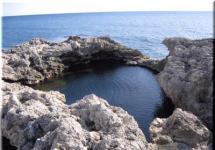
The coast is shallow. Along the shore there are surface, underwater and die stones. Near m. Anastasia Rock-remains with a height of up to 25 m. The rings are incorrect daily, in the aniva bay up to 1.6 m, in the Tatar Strait to 0.5 m.

Fig. 3 - Ulyanovka River.
1.5 soil and vegetable cover
The soils of the west coast are represented by borotherapy humorous reassembly soils. In the center of the northern part of mining acidic impregnated-multi-chumus opodoline soils. The rest of the territory is mountainous, forest, brown, acid nestoferous and weak-bellged. For the coast of the Northern and central parts Characterized sea terraces with a height of 5-60 m, sand beaches The width of 2-20 m. In the southern part of the peninsula, rocky cliffs appear with a height of 20-40 m, the beach is interrupted on the m. ConbeyEvka to m. Krönon, with the exception of the site p. Satinovka R. IRRA, stretches the strip of Valunov and the boulder, found out on the shore as a result of the shore deformation.
From vegetation, stone-meter-bambhouse forests, palpal and bambhouse thickets on the site of dark-haired forests with the participation of broad rocks are mainly common. In the central part in the ridge areas there were still fir-fir forests with the participation of broadening rocks. According to the valleys of the rivers Poaming vegetation, highlywood.

Fig. 4 - Spruce-fir forests.
Endemic types: Multi-Supil Coid (Sedum Pluricaule Kudo. ), Smolevka Sakhalinskaya (Silene Sachalinensis Fr. Schidt.) Common in the area of \u200b\u200bm. Kuznetsova.
1.6 animal world
Amphibians: Ordinary toad(Bufo bufo) Herbal frog(Rana Temporaria). Reptiles: Vilitary Lizard(Zootoca Vivipara). Birds: Solovy-Krasnicheka(Luscinia Calliope), Okhotsk cricket(Locustella Ochotensis), Red oatmeal(Emberiza Cioides) Collar oatmeal(Emberiza Fucata), Chinese Zelenushka(Carduelis Sinica), big ultimate (Trianing Nebularia), Silver Chaika(Larus Argentatus), Siza Seagull (Larus Canus), Pacific Chaika(Larus Schistisagus).

Fig. 5 - Solovy-Redish(Luscinia Calliope).
Mammals: Clawed Barozubka.(Sorex Unguiculatus), Zayak-Belyak (Lepus Timidus), Gray rat (Rattus Norvegicus), Retal dog(Nyctereutes Procyonoides), Brown Bear (Ursus Arktos).

Fig. 6 - Brown BearUrsus Arktos).
1.7 Historical and Geographical Essay
For a long time, the territory of the peninsula was the experiencing between Sakhalin and Hokkaido, i.e. He was part of the huge Sakhalin-Hokkaid Peninsula. As a result of repeated warming, cooling and climate change caused by the glacial era, he repeatedly changed his outlines until 12 thousand years ago did not separate from Hokkaido finally. It is at this time that the "obsidian trail" is a breakdown - the ones on which the migration of the oldest hunters for obsidian was carried out: the raw material for the manufacture of workers of labor and hunting.
The most ancient parking on the peninsula is a parking lot of 5 thousand years at m. Kuznetsova. This parking belongs to South Sakhalin culture. Residents of this culture were built by a quadrangular apparatus, used for the manufacture of tools of labor and hunting local rocks of Yashmoids, silicon breeds, which find finds on these sites. As a rule, they are confined to high terraces, because The sea level at the time was high enough.
The economy of ancient tribes was gradually formed. Along with the gathering and hunting, tribes who lived on the coastline were also engaged in sea gathering and hunting on the marine beast. Naturally, the traditions of fisheries developed. The culture of hunters, fishermen and sea hunters was formed finally by the middle of I thousand BC. and reached his heyday to V c. AD During this period, the parking lots are located along the shores and the mouths of the Peninsula rivers. Residents widely used the protective properties of the terrain, an example is the natural fortress on the m. Vinis. Being on the periphery, however, the residents of Sakhalin felt the impact of the strongest neighbors who had the state system by that time: states such as Fog, the Golden Empire, the Empire Yuan and Min, expanding their borders to the east, naturally stumbled on the island. The most tangible for residents of Sakhalin was the invasion of Manchurian detachments in 1286 and 1368. It was at that time that numerous settlements on Sakhalin were built, which called "Chasi".
Kiasi - monuments of historical times, these are earthworks intended for defense and habitat. Otherwise, we can say that this is a fort or strengthening. The distribution area of \u200b\u200bChasi covers the territory of Japan and Karafuto. The question of who used kids controversial, but generally the dominant opinion is that it was Aina. In the peninsula, Krylon are Chasi Siranusi (West Coast) and Thicia (East Coast). Chasi in Siranusi is located about 2.5 km to Northwest from the m. Krölon on the west coast, on the shore of the nameless stream, flowing into the Japanese sea 100 m to the west of the settlement. From the north-western and northeastern winds of the North-Western and northeastern winds, the town of Cape of the rock in the West and the sorts of the mountains ended in the east. The fortress occupies a very advantageous military-geographical position - located in the center of the sea communicative node. Within direct visibility, lying m. Soy, the island of Monerone and the punch. These circumstances, in the conditions of the coastal navigation, existing in the ancient times, did the Syranusi area with a convenient observation, trade and defensive point. At Cape, Krölon closed one of the 8th most important roads of Japan, connected about Kyushu with Primorye. The name of Siranusi from the Aynsky language is translated as "a place where a lot of rocks", "place exposed to the action of tides and sings."
This fortress was known since the days of the Japan's Faudal Government in 1192-1867. But it is still unknown who, when and for what purpose built it. According to the oral legend of the natives, Sirana-C was built by Prince Esuitsune, who directly participated in construction. According to other sources, Aina say that the fortress was built during the invasion of "Rabungur", in Ainski - "Rabun" -more, and Gur Group of people who arrived from the sea from the West. The Chinese belonged to Gur. This led to the emergence of 2 different hypotheses, but each of them testifies, at least that the confusion of Chiasi was not made by Aina. The Japanese archaeologist ITO Nobuo believes that from all the fortifications that have survived on Carafato, only Siranusi is surrounded by a square shaft, where there are gates in the center of each part, which is an earthen fortification made by Chinese type. Currently, anywhere will no longer see the strengthening with a similar design, except Siranusi. Probably, the arrangement was initially strengthened with shafts from four sides, but over time, by virtue of natural and anthropogenic factors, 2 trees lost. Currently, the settlement has numerous traces of economic activity of the last decades: during the construction of the helicopter platform and the laying of the road was destroyed by the northeastal shaft of the fortress, it happened in 1940-50s. The fortress-town is a unique historical monument. Products from China transit passed through these points to Japan. They were trading centers and the local population.
During the 20th century, the Japanese, after the union of the country under the authority of the emperor from the Tokugawa dynasty, begin to actively move to the north, ousting the Hokkaid Ainov to the south of Sakhalin. This caused hostility with Sakhalin kinds of Ainov, Nivkhov, orokov. The first Japanese expedition visited Sakhalin in 1635. She was sent by the head of Matsumae, who spread his influence on the whole island of Hokkaido, in order to study the lands lying north of his possessions. The expedition reached Cape Notoro (Krönon) and soon was forced to return back. The following year was sent to the Vassal of the genus Matsumae Comiti Sedzaeman. He spent on the island for more than a year and in 1637, following the southeastern coast of Sakhalin, reached the bay of patience.
Since the 1930s, the Japanese government begins to conduct self-insulation policies in order to strengthen the segun-ta. According to 1633-1639. first limited, and then categorically proceeded by the departure of Japanese subjects
outside the country. The construction of large ships suitable for long-haul swims and, finally, all Japanese ports were closed for foreign vessels. At first, such decrees were carried out unquestioned, but self-isolation policy did not stop the active activities of the Matsumaea clan in the north. In 1650, 1689, 1700. New expeditions were sent to Sakhalin from Hokkaido. And since 1679, seasonal settlements of Japanese fishermen appear in the extreme south of the island. And this was not considered as a breakdown of prohibitions, because The Japanese government considered all the Aynian lands as their own.
In the 90s of the XVIII century. Japanese trading factors appear on Sakhalin. The largest shopping center was the village of Siranusi. For the conclusion of trade transactions with the Japanese, Aina, Nivhi (Amur and Sakhalin), Manchurian and Chinese merchants came here. At the turn of the XVIIIXIX centuries. Japanese government officials and guard posts appear on the extreme Sakhalin.
In the late XVIII century. European researchers exhibit interest in Sakhalin and Kuriles. The expedition of the Dutchman M.G. Frieza Peninsula Krölon was adopted for the continuation of Hokkaido, the blame of this mistake was fog, frequent for this time of year. The error existed for almost 100 years, while in 1787. French navigator J.F. Lapruz during his expedition did not open the strait, named after himself, and did not describe the West Sakhalin coast.
I encountered in the north of Melie and considering the island of the peninsula, he descended to the south and rose to anchor parking near M. Maidel. During the parking, he took on board the inhabitants of the Krylonsky P-Oov, replenished the reserves of fresh water and unlocked a small group of researchers who climbed into the city of Krölon and examined the surroundings. In the south of Sakhalin, the French names appeared, preserved so far: Moneron, Krönon, de Langle.
Moving from the south to the north and from north to south, expanding the boundaries of their states, Japan and Russia faced completely and irrevocably at the beginning of the 4th century. The construction of military posts and temporary fishing settlements by the Japanese spawned a natural hostility, in which the locals turned out to be a third party between the hammer and an anvil. Crylon, due to its geographical proximity, was under the influence of Japan for a long time, while the entire territory of Sakhalin did not finally belong to Russia. This was achieved in difficult negotiations, as a result of which on April 25, 1875, the St. Petersburg Treaty was signed. Under the Treaty, Japan was inferior to Sakhalin in exchange for the Kuril Islands owned by Russia (north of Urup to Sochazu inclusive). A few months later, an additional article was signed in Tokyo, which envisaged the right of residents of the exchanged territories to remain at the permanent residence in their areas, while maintaining complete freedom of classes without any tax. These benefits did not apply to the indigenous population.
Despite the signed agreement, the Japanese continued to fish in close proximity to the shores, pester for repair work. In addition to few settlements in the north of the Peninsula, Krönon both in the Western and eastern BankHe was uninhabited in the cold season. When warming resumed fishing from Japanese poachers. And so went up to the Russian-Japanese War 1904-1905. Cape Krylon was quite dangerous Moz For vessels transported various goods in the Korsakovsky post. In particular, on May 17, 1887 near the m. Siranusi wrecked the steamer of the Voluntary Fleet "Kostroma", the next from the Korsakovsky post in Doue. Inaccurate marine maps It snatched on the stones and sunk on May 23. In this regard, in 1888, the Topographic Party under the leadership of S.A. was sent to Krylon Varyagina consisting of 22 people. The geodesic coordinates of the semi (Kuznetsov), Tsyia (Anastasia) and Krylon were identified, refined coastline And the depths in the strait of the lapere are simulated. In memory of the death of "Kostroma" on the shore, a small chapel was built from the wreckage of a vapor to the face of Nicholas and the inscription "Kostroma 1887".
Naturally, there was a need to build a lighthouse on Krylon for the safety of ships. Astronomical point on m. Krölon was defined in 1867 by Lieutenant Staritsky, and in 1883 the construction of a lighthouse was started. Works were carried out 35 days thirty peaks. During this time, a wooden tower with a height of 8.5 m, a house for a caretaker, a vegetable garden, and all this was discouraged by a fence. In addition, a powder cellar was built and the road to the shore was laid. The builder of the Mayak was Captain Kazarinov V.Z. The lighthouse was equipped with a luminaire with 15 argon lamps and a reflector, in addition, a 20-powder bell was supplied and a two-pound gun. The lighthouse light was visible at a distance of 15 miles. On June 30, 1883, the Lighthouse was consecrated by the bishop of the Corsakovsky post.
Martimian, specially arrived from Blagoveshchensk. In 1885, a 12-meter tower was built with refrunning, specially brought to the cape in order to establish it on the hazard stone. A steamer "Tunguz", who arrived in the installation of this tower, did not cope with the work, so the tower was dismantled and taken to the imperial harbor in Primorye, where they installed it at the entrance to the harbor. The most disturbing time of the end of the XIX century. For residents of the Krylonsky Lighthouse was 1885, when 40 refrunning faces ran from the Korsakovsky post. Most of them, the eastern shore was reached by the Krylonsky Lighthouse, where he loosened the food warehouse, captured the boat and fled to the sea to Japan. There were introduced by German sailors, but were exposed and sent back to Sakhalin. In essence, the Crylonian lighthouse, being the only settlement in the Far South-West Sakhalin, represented a rather attractive object for a runaway. In September 1885, the other group of Katorzhan fled from the Korsakov post and killed near M. Ventos of the senior warder and his assistant. In memory of this villainisk, the Cape was renamed in m. Kanbeeva.
Cape Kanbeeva sincecore has discouraged the glory of one of the most hard-to-reach places of the aniva coast. Aina, who fired near the cape on Nerpen and Syvucha, called him Vennniki -"Evil Demon." Japanese fishermen from the middle of the nineteenth century, the seasonal settlements arranging here, called his rocky cape and stone banks near him Randomari - "Stop on the way." Runny religion, coming to the village of Tona (Okhotsk), brutally killed 11 Ainov, including a 4-year-old child and elder. Then four convicts moved from Oz. Tunaycha to Oz. Chibisan, stole a boat and on it, going out to the Bay of Aniva, headed for Lighthouse Krönon. On October 3, in 20 versts from the lighthouse, they noticed the older warden of the Tym Prison of the Nobleman Kanbeeva, who with several refrigerated reinforcement a herd of bulls bought from the Lighthouse. By stating that they go to surrender, running joined to the ward. Overnast, one of them drove Kanbeeva and one exile. Caught subsequently the killer was sentenced to the death penalty. And the cape in memory of those events was renamed, but the new name was not immediately arrogant.
On August 7, 1894, construction of a capital building for a lighthouse on m. Krölon began. The construction was carried out by the Devnries of Shipulin and Yakovlev with the help of 25 Korean workers. Red bricks have been imported from Japan, Origorian pine from America. The lighthouse was supposed to be equipped with the Lighting Device of the Barbier Bernard. By August 1, 1896, all work was completed. The building was built and combined with residential premises, a new siren was installed for feeding signals in foggy weather, a new bell of 488 kg weighing. So he stayed to the present. Only residential premises were turned into household, the bell in 1980 was removed and is located in the military unit in Korsakov, and instead of him on the lighthouse, the reserve bell of Japanese production from the lighthouse on the m. The paddle, that on Kunashir.
At the end of the XIX century. The Far Eastern frontier of Russia was protected by the Siberian Flotilla, since 1897, based in Vladivostok. Ships carried the cruising service, performed a wide variety of instructions from hydrological research to postal and passenger traffic. One of these ships was the Sevuchi sea gunboat. In the summer of 1889, the Syvucha commander Captain of the 2nd rank of Kasherininov received from the head of the Squadron of the Pacific Ocean Nazimov not quite ordinary task: the boat was supposed to accompany the head of the South Ussuri Mining Expedition of the engineer D.L. Ivanova, who produced the study of the geological structure of the coast of the Tatar Strait and the Japanese Sea.
On August 16, Sivuch went to the strait of Laperose along the eastern shore of P-ov Krönon. According to D.L. Ivanova Coast was interesting in geological terms, so the ship went 3-4 km from the coast, making frequent stops. Taking this opportunity, sailors constantly produced depths. However, putting them on the card could not be by the big inaccuracies of the shore contour on it. D.L. Ivanov produced geological studies in Kuznetsovo Bay.
On September 22, 1895, the Klielon Lighthouse visited Admiral S.O. Makarov, where a rake was installed with fugstoke division to measure the oscillations of the water masses in the Laperose Strait. Even earlier, in 1893, a meteorological stage of 2 category I was constructed next to the lighthouse. At the end of 1896, a complete solar eclipse was observed from Lighthouse, a complete solar eclipse was experiencing a specially sent for this by an expedition under the direction of General Miraera E.V. Maidel.
Xx in. marked at the beginning of the Russian-Japanese war in 1904. The team of the Krylonian lighthouse was strengthened up to 15 people instead of 8. The telegraph line from Lighthouse Kröno to Korsakov was built on September 30, 1904, despite the fact that the issue of its construction rose back in 1893. There was a little sense from this line, because . Lighthouse caretaker, together with the team, often resided in a state of alcohol intoxication. The duties of the caretaker practically performed his 12-year-old daughter, engaged in warehouses and contentment of the team.
On April 25, P. Mordvinov, the head of the detachment of 40 warriors and the I understated officer arrived at Krölon. This detachment was repaired by the telegraph line on the site m. Krönon r. Uryum, as well as the destruction of Japanese crafts and kungas. Acting at your own risk, P. Mordvinov with a detachment destroyed a pirate base on about. MONERON. The searches of the squad the Japanese were not crowned with success. The return of the decade to Cape coincided with the beginning of hostilities on Sakhalin, for 2 days the defense of the beacon was prepared. However, on June 26, a Japanese landing squad, consisting of cruisers "Sum" and "Chiode" and the 4th Montarosians approached the lighthouse. Peter Mordvinov, seeing the numerical superiority of the Japanese, gave the order to retreat in full, leaving the lighthouse. The Lighthouse remained a caretaker and the sailor of a boral who tried to burn a lighthouse, but the caretaker forbade him to do this, fearing to be punished Japanese.
The detachment of the poderuk, making a 7-day transition, connected with the detachment of the Captain Dvirsky squad in p. Petropalovskoe. Having kept in the forests of a month and a half, on August 17, he was completely destroyed by the Japanese in the upper reaches. Hire. So was the end of the Krylonian detachment under the command of Peter Mordvinov, whom the Japanese themselves respected for feats, considering a worthy opponent.
Period 1905-1945 In the peninsula, Krönon was marked by the appearance of the first permanent settlements. The main type of settlement on the peninsula was similar to the Japanese Hokkaido settlement system. In the mouths of large rivers, as a rule, a large settlement was located, deep into the Peninsula on the valleys of rivers left the road with a chain of farms. The main occupation of the local population, which is mainly from Japanese immigrants, remained fisheries, but the logging (East Beach) and coal mining (West Bank) have already been added to it. In addition, the population was engaged in gloomy. During this period, at least 50 were created settlementsMost were farms. Large-scale settlement peninsula existed on both coasts, had post offices, schools, shops. Immediately after the seizure of South Sakhalin, the Japanese began to pierce south along the eastern shore road to the Krylonian lighthouse. The Lighthouse itself was repaired, a meteorological station with a thoughtful rainwater collection system was built next to it. The meteorological station began work in July 1909. In 1914, a lightary complex was built on M. Sony (Kuznetsov). On the east coast of the peninsula, apparently, at the same time built 2 towers in Kirillovo and on m. Anastasia. In August 1945, 2 Battalion 25 of the infantry regiment was stationed on the m. Klionno stationed. Soviet paratroopers, landed for the liberation of the south-western tip of Sakhalin, met violent resistance from the Japanese. Unfortunately, the names of the paratroopers' warriors are unknown, like their number resting in a mass grave at the southernmost point of Sakhalin. At the end of the war, the Lighthouse was renovated and commissioned. From 1945 to 1947 The population of the Peninsula Krölon was repatriated. In 1947, Japanese geographical names were replaced by Russians. Russian settlers settled the peninsula and settled in the same villages. Japanese farms were looted and turned into hunting houses, some of them burned out, the other gradually collapsed.
Central settlements have been preserved longer, but they were closed in 1963, 1964, 1965, 1978, 1982. The largest - atlasovo, crossroads, tail, "last" longer "lasted". Previously, Anastasia could be reached by flight bus, but now, when the upper road on the m. Kanbeeva is abandoned, you can walk or sea. Historians and archaeologists entertain the monuments of the ancient and medieval history, tourists and photographers - the beauty of the "Stone Garden" on the right bank of the river. Anastasia. The traditional name of Camingia, according to his behalf, the Japanese fishermen called seasonal fishing, standing at the end of the nineteenth century, and the village during the Governorate of Karafuto. The first Russian name was given by Lieutenant N.V. Rudanovsky during a trip to the southern Sakhalin. On January 14, 1854, Rudanovsky from Siranusi on skis crossed the Bay of Aniva. Products are over, they failed to replenish them in Siranusi, so the first cape who had to go around the mountains, he called hungry. Under this title, it is placed on a map compiled by a lieutenant.
On Russian maps of the XIHXXH century. The new and old name of the cape is also mentioned. In a number of sources, the name is the rocks of two brothers, which gave the name of the flowing river. During the reign of the first Soviet administration, a great job of renaming settlements was carried out by the Civilian Office. In one of the first options in the "Help for the renaming of settlements ..." p. Tsyia was renamed Anastasia. In the "Notes" column, the explanation is "but consonant, accepted by the sailors." Many fishing vessels did not have their own card, and enjoyed old Japanese. In 1947, the Executive Committee of the Anivian District Council of Workers' Deputies was renamed with. Tsyia in Atlasovo "In honor of the discoverer Sakhalin Atlasov." Under this name, the village existed before its abolition in March 1978. Now this name is located in the PRAINRASTAVA Valley. At present, on the peninsula, the same picture as 100 years ago: on m. Krölon operates the lighthouse and meteorological station, military and border units are stationed, fishing mills are scattered during Putin during Putin, the fishing mills are scattered. On the west shore south of SHebunino, there are 2 border posts "Crossroads" and "extreme", occupied not so much border guard, how much survival, on the eastern shore to the south of Kirillovo is located on m. Anastasia, the position of which is the hardest due to insolation . In 1948-51 The Peninsula existed the South Sakhalinsky reserve. Unfilled petition ended during the Stalinist transformation of nature. On March 14, 1972, the stormy and sad history of the reserve "Peninsula Krylon" begins. Here is a brief retelling of stories on documents that managed to find (see Appendix A, B).
2 Tourist Objects on Peninsula Krylon
2.1 Nature Monuments
The territory of the Peninsula Krölon is rich in tourist natural objects. Types of tourism are mostly aquatic and hiking. Historical and unique natural objects of the peninsula are especially popular.
Cape Krilon by law, it may be called the open-air museum. Students Professor Sakhgu A.A. Vasilevsky in three hundred meters from Cape Krönon discovered the parking lot of people living here seven thousand years ago. The shards of Zhurzhen's dishes are found (Zhurzheni - tribes who inhabited in the X-XV centuries. The territory of Manchuria, Central and Northeast China, North Korea and Primorsky Krai. Speak on Chjezhensky language of the Tunguso-Manchur group. The largest state of Zhugzheney existed from 1115-1234 .), Far Eastern Empire deceased from the warriors of Genghis Khan, about three kilometers from the cape, on the terrace at the bakery river, found the remains of the fortress known to the archaeologists as the Krylonskie settlement, or Siranusi. The construction of a lighthouse at Cape Krölon was instructed by the head of the hydrographic part of the ports of the Eastern Ocean Captain V.Z. Kazarinov. Construction began on May 13, 1883. Works in which 30 reforts were attended, 35 days continued. Wooden tower with a height of 8.5 m, a house for a caretaker, a barracks, a bath. The lighting apparatus with silver-plated reflectors was equipped with 15 argant lamps. For the production of foggy signals on the lighthouse, a two-tone alarm cannon and a 20-powder bell were installed. On June 24, trial lighting of the lighthouse was carried out: with good weather, the fire was visible for 15 miles.
In the early 90s of the XIX century, there was a need for the construction of new lighthouses and finished signs on Sakhalin. On the one hand, this was caused by the emergence of new improved light aircraft systems, and on the other hand, the deplorable state of Sakhalin beacons. In the main hydrographic management in St. Petersburg, the "Plan for the production of lighthouse work in the Eastern Ocean" was developed, designed for 1892-1897.
A contract was concluded with the French firm "Barbier Et Benard", established itself so brilliantly that England famous for his sea priorities purchased its lighting devices for lighthouses. They consisted of one keroseinocal burner (instead of 15 oily on old systems) and gave a beam of light by force in 150,000 candles instead of several hundred on old. The burner light focused in a lens with a diameter of up to 1.5 m, consisting of several rows of glass rings marked in a bronze frame.
Work on the construction of new lighthouses began in 1894. On August 7, the brick brought from Japan began the construction of a new Krylonian lighthouse. The solution to build a red brick beacon Engineer K.I. Laopold, who led the work, explained the features of the area: If you look at the lighthouse from the sea, it merges with the sky, so it was necessary to make it more distinguished.
By August 1, 1896, an installation and adjustment of the lighting device was completed on the Klionth Lighthouse. In the room located on the southernmost point of Cape, Krönon was mounted a new pneumatic siren with a kerosene engine manufactured by the English firm "Kanter, Harl and K". It was intended to feed "foggy signals" with a duration of 5 seconds with intervals of 100 s. Next to the siren building housed a special signal gun of the sample of 1867.
In the history of the Krylonsky lighthouse there were a lot of wonderful events, one of which was a visit to the Lighthouse with the famous Russian researcher and the navigator Admiral S.O. Makarov.
On September 22, 1895, a record was recorded in the Watchthe magazine of Krölonsky Lighthouse: "Kornilov cruiser arrived to the lighthouse. Having visited the Mayak counter-admiral Makarov ordered to establish a footbath. On the part side of the age-old brand. " The preserved remnants of the age-old brand today are the only evidence of visiting Sakhalin Sakhalin Island. Cape Krilon watched A.P. Czechs from the board of the "Baikal" during the Sakhalin Travel in 1890. On the territory of the Cape, you can meet the remains of the Japanese and Soviet fortifications (dots, the network of underground strokes, intended for the defense of the southern frontiers of the island), buildings from the Red Japanese brick of another royal building, here also there is a valid military and border part, the meteorological station is very original building (building with water intake of rainwater). This meteorological station began its work in July 1909, exercising meteorological and sea coastal observations

Fig. 7 - Cape Krylon.

Cape Vintis (the city of the rusher) is reminiscent of the cake with the walls that are obscured in all directions. Narrow alters connect it with the shore. The name is translated from the Ayn language as a "bad dwelling". Night, bad Ains called the capes who were dangerous to travel around the boat and had to go around the shore. For the trapezoidal shape, the cape is also called a knot. On his flat top (height 78 m) several archaeological sites were found. ancient man. You can climb on the top of the mountain only by its oriental, overgrown with a slope, using the rope located there.
Fig. 8 - Cape Vintis.
Cape Kuznetsova - State Zoological Monument of Nature of Regional Meaning, founded in 1986. The name of the Cape received in honor of the captain of the 1st Rank D.I. Kuznetsova who commanded the first detachment, sailing to the Far East in 1857 for the protection of Russian borders.
Cape is located on the south-west coast of the Peninsula Krylon. The relief of the monument is represented by a pollen plated surface and sea ripples. Since 1857, the detachments of the Pacific Courts were sent to the Far East. The first detachment commanded Captain D.I. Kuznetsov, in honor of which Cape was named. In the south, he ends with a rock, resembling a person's face in the profile. In the central part of the cape on his most end, the Lighthouse "Kuznetsova", built by the Japanese in 1914. Previously, the cape and the bay were called Sony that translated from Ainsky means columnar stones or reefs and reflects the features of this place. At Cape is a fan of a nerve, as well as a large colony of sea birds - cormorants, chums, cleansing.
The underwater world of Cape is very beautiful and interesting, in many ways similar to the island of Moneron. Cape represents the greatest value in ornithological terms: the main migration pathways of birds are held along the eastern and west coast. At almost brazed slopes of sea terraces nest cormorants, falcon, seagulls, kayra, hawk. The rarest species of birds listed in the Red Books of the Russian Federation and Sakhalin region: Japanese crane, horned broth, green dove, Japanese star, tanger, medium white Heron, Japanese white, red-legged hand, Sappsan Falcon, Quail Japanese, etc.
If you rise to Kuznetsovskoe plateau in good weather you can see Japan: High cone island-volcano risiri, the island of Ribun, Hokkaido Island.

Fig. 9 - Cape Kuznetsova.
Cape Waterfalls Zamiylova Head. Cape Zamiylova Head - Long and narrow, connected to a slightly stretched with a sandy jumper height of 25-29 m. At the lowest mark of this area there are two waterfalls with high 25 and 28 m (1.5 km north of the mouth of the Zamiylovka River).

Fig. 10 - Waterfall Cape Zamiylova Head.
Stone danger. The rock, located 14 km south-east of Cape Krönone - the foreskin of the Sakhalin Island - in the Laperus Strait. It is a small group of naked, deprived of the vegetation of stones. Length about 150 m, the width of about 50 m, the height of 7.9 m. For Europeans, she opened it in August 1787, the Laperose expedition, which was called dangerous (Fr. La DangereUSE), since she greatly hampered the movement of vessels on the strait of Laperose, What was aggravated by frequent fogs in the summer. To avoid a clash on the ships, sailors were exhibited, the responsibility of which was to listen to the ridge of the Silence, which are on the hazard stone. In 1913, a concrete tower was built on a rock with an autonomous lighthouse with a height of 18 m, a foggy bell was installed next to it.

Fig. 11 - Stone danger.
Some of the information about the monuments of this area is reflected in reports and field research as Sakhalin archaeologists. Many of them are published. For example, a great contribution to the study of monuments and the entire peninsula was made by S. M. Primezhin.
In this certificate, this information is maximally complemented and summarized. Works on the description of the monuments of archeology in the area and the search for new are due to the acute need to carry out security measures caused by the stormy economic development of the coast in last years. In addition to the traditional summer distant pastures of the state farm "Border", recently, seasonal fishing brigades are broken here on each river. Fully destroyed predominium plots on the rivers Bachinskaya, piggy bank, southern repair. Settlement southern repair. The settlement is 8 km south-west of P. Taranai. It is located on the caustic terrace of the right bankare. Southern repair. In a row, there are 5 kittlers of semi-flowed dwelling of square outlines in size from 5 to 10 m in the diameter, a depth of 0.5 m. The territory of the settlement has gripped with small birch, bamboo, grass and shrub. At the outcrops of the cultural layer, lifting material fragments of ceramics "find" -tole-free ceramic vessels with inner ears used by Aina South Sakhalin in the XII-XVI centuries. The settlement was first studied by scientific employees of the Archaeological Laboratory Yusgpy A.A. Vasilevsky and I.A. Samarin in 1992.
2.2 Historical objects
Fortification
2.5 km north-east of Cape Krölon found the remains of engineering and technical structure, most likely, which is a Japanese searchlight post or an artillery position. On the edge of the 20th terrace there is a lunetic, surrounded by a low shaft from three sides. From it perpendicular to the edge of the terrace there is a flat trench of 3 m wide. The trench of 75 m long ends with concrete shelter, from which two cameras are preserved. The northern chamber is a hangar with a gate, in which there was a mobile searchlight installation, southern warehouse or residential premises. The western part of the construction is collapsed, the remains of the hangar and domestic room with a stove are preserved.

Fig. 12 - fortification.
Shebunino Parking 1 (Miningii)
Located on the shores r. Shebunink near the mouth. Stone tools and ceramics of cultural culture of epidemnev, cracking and riddle.

Fig. 13 - Parking Shebunino 1.
Parking Ivanovka 1 (Muidomari)
Located on a 6-10-meter sandy sea terrace 3.5 km south of P. Shebunino on the shores of the stream with a waterfall. The monument opened Kimur Sinoku in 1932 in 1981 S.V. Gorbunov gathered lifting material here, and in 1988-1989. conducted an excavation, as a result of which from the excavation of 328 square meters. I received 92,000 artifacts and ecoctacks, including many wood and faunistic residues, wood products, bones, stone and ceramics such as Enouar, dated VII-VIII centuries. X.E. Wood products are of the greatest interest: bows, arrows, traps and self-tracking details, inhibitory drills for the extraction of fire, animal figures, mainly pigs, which speaks of the development of pig breeding.
3 Development of a water and motor route "Cape Krilon"
Thread route : Sebunino village - Cape Round - Cape Kuznetsova - Cape Krönon - Cape Anastasia - Cape Canbaevka - Village Kirillo.
District of the hike : The route passes through the territory of MO: "Nevelsky City District" and "Anivan City District".
Type of tourism: Water (pedestrian).
Season holding: June-September.
Duration: 3-4 days.
Length: 170 km.
The degree of complexity: 2 Category of complexity. TRAST, number and experience of participants. The recommended age of the participants from 16 years. For the safe passage of the route, the recommended number of the group is up to 15 people. To participate in the water campaign you need experience in passing routes 1-2 k.s.
Cost: 64,000 rubles.
3.1 Description of the area
On the map Sakhalin Island reminds Fish. The left tip of the "tailfold" is occupied by the Peninsula Krönon. Its length is 90 km, and width from 20 to 40 km. Due to the high cloudiness, the duration of solar activity on the island is an order of magnitude lower than on the mainland. But the Peninsula Krylon is the warmest place in the Sakhalin region. Periodically, residents of urban districts can rejoice in warm and even hot, sunny and dry fly. The coastal strip is rolled with wide spacing with thick grain grain and small mountain-type robusts, flowing into the Tatar Strait. The largest of them are Catcher, Nevelsky, Cossack. There are small mountain lakes, waterfalls, mineral springs.
For a long time, the territory of the peninsula was the experiencing between Sakhalin and Hokkaido, i.e. Krylon in the past was part of the huge Sakhalin-Hokkaid Peninsula. As a result of warming and cooling caused by glacial epochs, he repeatedly changed his outlines until 12 thousand years ago did not separate from Hokkaido finally. It is at this time that the "obsidian" trail "- paths, for which the migration of the oldest hunters for obsidian, raw materials for the manufacture of workers of labor and hunting was carried out.
The expedition of the Dutchman M.G. Frieza Peninsula Krölon was adopted for the continuation of Hokkaido, the blame of this mistake was fog, frequent for this time of year. The error existed for almost 100 years, until in 1787, the French navigator J.F. Laperuz during his expedition did not open the strait, called subsequently in honor of him, and did not describe the West Coast of Sakhalin. Faced in the north with a shallow water and, having considered the island of the peninsula, he went south and rose to anchor parking near Maja Madel. During this parking, he took on board the inhabitants of the Krylonian Peninsula, replenished the stocks of fresh water, directed a small group of researchers to the shore, who climbed into Mount Klion and examined the surroundings. In the south of Sakhalin, French names appeared, preserved to the present - Moneron, Krölon, de Langle.
For a long time, Krylon was under the influence of Japan for a long time, until the whole territory of Sakhalin did not belong to Russia. However, this did not interfere with the Japanese to make fishing in close proximity to the shores, pester to the shore, producing repair work there. In addition to the few settlements in the north of the peninsula, both in the Western and Eastern Bank, he was uninhabited during the cold season, a fishing from Japanese poachers resumed when warming was warming. So continued until the Russian-Japanese War of 1904-1905.
Peninsula Krylon is a fairly unique place in its beauty. The landscapes of the peninsula are rich in their history, as well as pleasantly surprise the diversity of fauna and flora. Here you can find rare plants and watch various animals and birds. In the peninsula, Krönon, the places of settlement of the former population of the Peninsula - Japanese and Ainov are partially preserved to this day. Port-bucket is unique and being a historical monument to Cape Canbeeva.
The most southernmost point of the peninsula is the conjunctional of Cape Krylon. The name was given by the Great French navigator Jean-Francois de Laperuz in honor of the French warlord Louis-Balbez de Krylon. From the north, the Cape is connected by a narrow, but high and climbing curtain with the Krylonian Peninsula, which in the West is washed by the Japanese Sea, in the east - the waters of the Bay of Aniva. From the south is the Strait of Laperose, separating Sakhalin Islands and Hokkaido. At Cape, the old Russian signal gun was preserved, a meteorological station is working, there are a lighthouse of the Pacific Fleet and the military unit.
The first temporary Lighthouse Krönon was built on May 13, 1883. The building of the lighthouse was a log wooden tower with a height of 8.5 meters. Then the barracks for the Lighthouse, Bath and other economic buildings were built. The lighting light unit consisted of 15 argant lamps refilled by oil, and was equipped with a silver placed reflector. Fire lighthouse gave a continuous white light. For feeding signals in the fog on the lighthouse there was a two-pound signal gun and a 20-powder bell.

Fig. 16 - First Temporary Lighthouse Crönge.
On August 7, 1894, construction began construction of a new lighthouse building next to the old building from the Red Brick brought from Japan. By August 1, 1896, the construction of a new lighthouse building was completed and a new lighting device of the French company was installed on the lighthouse. In the postwar years in 1980, the inhabitants of the Krylonian lighthouse, who lived in the May and Technical Building, moved to the newly built 8-apartment house. A 3-kilometer water supply was conducted to it, a pumping was built. Alteration was subjected to a lighthouse - a duct roof was dismantled. A new flat roof was flooded with Wara, but now it does not save, and the building is mercilessly flowing so that the contacts on the equipment are sometimes closed.
In the 1950s, on the most southern tip of Cape, Krigon stood a small monument, made of natural stone and delivered, on memoirs of old-timers, in 1945. By the decision of the Sakhalin Regional Executive Committee of March 9, 1971 No. 98, the monument was put on state security.
Part of the route passes along the territory of the zoological monument of the nature of the regional value "Cape Kuznetsov". The territory of the Monument of Nature is the only year-round roofing of silence and seals in the south of Sakhalin. The Valley of the Kuznetsovka River is the place of gravity of many rare plant species and the nesting site of rare bird species. Basic security objects: roofing of silence and seals; nesting places of rare bird species; Places of growing rare and endemic species of plants listed in the Red Books of the Russian Federation and the Sakhalin region.
Protection Mode: The water route does not pass through a specially protected natural area; In the event of a pedestrian campaign, it is necessary to familiarize themselves with the regime of the protection of the nature monument of the regional value "Cape Kuznetsov".
Description of the route
The route is of great popularity. Among Sakhalin tourists, he is interested in pedestroders, jejers and vodnikov tourists traveling on motor-sailing ships or marine kayaks. The route is replete with a large number of capes, difficult-scale clamping sites, complicated by the absence of settlements. This route is particularly interesting if watching the banks of the Krylonian Peninsula from the sea, traveling on small courts.
The route can be started from the village of Shebunino, where you can get in the vehicle by any passability. The first amazing place that the traveler sees from the sea is Cape Windis and the Mountain "Rusper", which is on the caution and is a rock with a flat vertex and steep almost with steep walls. From afar, the cape is similar to the island: when observed from the north and south, the trapezoidal, and from the West - Square. Around this cliff you can see many large stones of different shapes and species, crabs and nerves are found here. There were several archaeological sites of an ancient person on the flat top of the cape (height 78 m).
The name Cape Windis is translated from the Ayn language as a "bad dwelling". Night, bad capes called the cauters who were dangerous to travel around the boat and had to go around the shore. For the trapezoidal form, the mountain on the caulation is also called the "Running". You can climb on the top of the mountain only by her Eastern, overgrown with a slope, but the last 7-8 m to overcome without special equipment is quite difficult.
Next, on the route, another attraction is the zoological monument of Nature "Cape Kuznetsov". This place is not even the beauty of the shore. In the direction of the southwest for 2300 meters the strip stretches sheer cliffs with heights up to 50-60 meters. From geomorphological objects, giant "fingers", "Arches", "Gate" can be distinguished - all this in a picturesque disorder is scattered near the shore. The shores themselves are increasingly hanging over the surface of the water, forming huge wagenic niches. The vast zone of Benchu \u200b\u200bgoes into the strait of about 600-800 m, so the waves do not come to the shore in calm sunny weather. In the south, the cape ends with a rock resembling a person's face in profile.
Currently, Kuznetsovka River is located in the lower reaches of the Kuznetsovka River - as people are called the subsidiary farming of the Cape Kuznetsov enterprise. This closed place is fenced with cordon, followed by ecoposalia. There is a small church on the territory of the ecoposal. And indeed, who and what is not here there is no - on the shore of the sea horses, pigs, goats, rams, turkeys, ducks, geese. Found shelter and wild animals - dike, ostrises, Lisenok Yashka, Bear Mashka.
In the central part of Cousse Kuznetsova (the Japanese called him Sony), at the most tip of the Kuznetsovo Lighthouse, built by the Japanese in 1914. Its height above sea level is 78.5 m. Previously, the cape and the bay were called Sony that translated from Ainsky means the columnar stones or reefs and reflects the features of this place.
The southern tip of Case Kuznetsov goes into a two-kilometer beach, stretching in the western direction to the long and narrow cape Zamiylov head. Cape has a height of 87.5 m. At the top there is a trigopunk. The elongated Cape is surrounded from the north of the bay chambers, on which there are sandy beaches, from the south there is Cape Zamiylova's head.
Moving to the south, the route is approaching the long-awaited Cancer of Krylon - the southernmost point of the peninsula. This is one big Japanese rejection, which you can walk for weeks in search of military dollars, underground strokes, guns, trenches. In these places it is worth visiting the Lighthouse Crørigon with a height of more than 8 meters, which has a unique and long history, as well as a monument established on the Cape in honor of the deceased warriors in the liberation of southern Sakhalin in 1945. It is recommended to make a day at Cape to study local attractions. At Cape is a border shop, where you need to notice a visit. Also for the movement of small vessels requires a notification of the border service.
Further, the route will go on the other side of Sakhalin along the Bay of Aniva already in the northern direction through interesting and beautiful Capes Anastasia, Kanbeeva and ends at the mouth of the river Uryum (the old village of Kirillovo). Throughout this section, fishing mills are often found, and in the sea, the shutter nemod (care should be taken on small courts). From the river Uryum, you can travel by road to Yuzhno-Sakhalinsk.
In general, when leaving the route on a small vessel, it is necessary to take into account the risks associated with the weather, it changes very quickly in the area. Under the passage of Cape, Krönone needs to take into account the suloids and constant flow of the strait of the lap.
List of sightseeing and tourist attractions: Cape Windis, Cape Kuznetsova, Svoyuchi Cape Kuznetsov, Cape Krölon, p. Atlasov, Cape Canbeeva; Throughout the route, beautiful landscapes, the picturesque sea and hill are opening.
Check in and check out from the route: To the beginning of the route you can reach the motor transport of any passability to Sebunino village; Departure from the route passes from the mouth of the Uryum River (Cyrillovo).
Emergency entry options, departure or exit: At the site of the route from Sebunino to Cape, Krölon can be released from the route on the transport of increased passability. Special difficulty on the car causes the passage of Cape Kuznetsov and clamp in front of Krylon. It is also possible to depart by vehicles of high patency on the eastern plot of Krönon from the river Uryum to the Moguli River (special complexity - passing cars through the mouths of rivers). On the plot from Cape Krönon to the River Moguli, the way out of the route is possible only on foot (through Cape Kanabeva Disproversion) or water transport.
Places of parking and their description. Choose a good parking easily: large glads, a sufficient amount of firewood, clean water of small streams flowing into the sea will make it possible to comfortably comfortably equip the camp.
The most interesting and comfortable parking lots:
1. Cape Windis - the North side, there is a small stream, good glade, little firewood.
2. Cape Kuznetsova (Komoy Bay) is a beautiful cozy place closed from the wind, a lot of firewood, the water from small streams.
3. The back of the Bakery River (Disinces Before Cape Krylon) is a comfortable parking lot, good water, firewood on the beach.
4. Cape Anastasia is a comfortable bucket for sludge in bad weather, the territory is polluted by technogenic garbage, the fishing mill is often located.
Conclusion
The goal of the work was to considerse and identify the tourist capabilities of the Peninsula Krölon and the estimation of the natural conditions and resources of the peninsula for the development of tourism.
To achieve this goal, a number of tasks were delivered before work:
1. The geographical position of the peninsula determines its uniqueness. Peninsula Krylon is a fairly unique place in its beauty. The landscapes of the peninsula are rich in their history, as well as pleasantly surprise the diversity of fauna and flora. Here you can find rare plants and watch various animals and birds. In the peninsula, Krönon, the places of settlement of the former population of the Peninsula - Japanese and Ainov are partially preserved to this day. Port-bucket is unique and being a historical monument to Cape Canbeeva.
2. A large number of natural and historical monuments, some of them are difficult to access, in addition to their uniqueness, it even more attracts tourists.
3. Despite all the beauty of this place, the peninsula is far from a tourist place. There are no excursions and tours here, there is no tourist bases. It is determined by the fact that, near the semi-week, Krönon meet two currents. Cold from the Sea of \u200b\u200bOkhotsk and warm from the Tatar Strait, which ensures windiness and raininess. You can only get here by car or by your own move by organizing a campaign. In any case, unfavorable weather conditions do not stop those who decided to visit this unique peninsula.
List of sources used
1. High M.S. History of the Sakhalin region from ancient times to this day / Yuzhno-Sakhalinsk, 1995. With 64-78.
2. Gorbunov S.V. Zoomorphic figures of parking Ivanovka // Studies on the archeology of Sakhalin and the Kuril Islands. II. Abstracts of the conference. Yuzhno-Sakhalinsk, 1989. p. 14-15.
3. Gorbunov S.V. Catalog of archaeological collections of the Nevelsky historical and local history museum // Archaeological monuments of Sakhalin and Kuril Islands. Vol. 2. Yuzhnoshalinsk, 1996. 123.
4. Glovyovsky V.E. Catalog of the Museum of Society for the Study of the Amur Region // Notes of the Society for the Study of the Amur Region (Vladivostok Branch of the Amur City Department of the IRGO). 4.1, T. IX. Vladivostok, printing house "Commerce and Industrial Bulletin of the Far East." 1907, p. 121.
5. Ito Nobuo. Earth strengthening of Chinese type on Karafuto // Bulletin of the Sakhalin Museum. № 3, 1996. p. 36-41.
6. Klitin A.K. Opening Sakhalin again: with a backpack in Sakhalin and Kuril Islands. - Yuzhno-Sakhalinsk: Publisher "Sakhalin - Priamur Vedomosti", 2010. - with. 304.
7. Klitin A.K., Brovko P.F., Gorbunov A.O. Waterfalls. Series "Natural History of Sakhalin and Kuril Islands" / Yuzhno-Sakhalinsk: State Budgetary Institution of Culture "Sakhalin Regional Local Lore Museum", 2013. - with. 168.
8. Multimedia Encyclopedia "Reserved Territories" / Sakhalin Regional Public Organization Club "Boomerang", 2010 p. 131.
9. Niilozh T., Utagawa H. Archaeological monuments on southern Sakhalin. Sapporo, 1990 (in Japanese). from. 34-36.
10. Monuments I. memorial places Korsakovsky district / MU "Centralized Library System of the Korsakovsky District". - Korsakov, 2008-s. 56-84.
11. Embrella E. .L. , M.Yu. Lozova, S.V. Gorbunov. Alexandrovskoe coast Trillium.- Yuzhno-Sakhalinsk: Publishing House Kano, 2001. - s. 110 - 121.
12. Prevukhin S.M., M.Yu. Lozova, S.V. Gorbunov. Peninsula Krölon Trillium.- Yuzhno-Sakhalinsk: Publishing House Kano, 2001. - p. 93 - 110.
13. Pervukhina, M.Yu. Lozova. Narrow-collar steam locomotives of the ignevo mine // Bulletin of the Sakhalin Museum. No. 6. Yuzhno-Sakhalinsk, 1999. p. 350 -355.
14. Plotnikov N.V. Archaeological exploration in the Nevelsky district in 1990 // Local Education Bulletin, 1991. With 201-204.
15. Prokofiev M.M., Derjugin V.A. Gorbunov S.V. Ceramics of culture Satsonon and her finds on Sakhalin and Kuril Islands. Yuzhno-Sakhalinsk, 1990. With 187-190.
16. Sakhalin / Sakhalin Energy Invest Company LTD. - Vladivostok: Publishing House "Orange", 2013. p. 156.
17. Ryzhavsky G.Ya., Tashoyan F.V., according to Sakhalin and Kurilah. 1994. - with. 176.
18. Samarin I.A. Krylonsky detachment // Bulletin of the Sakhalin Museum. № 1, 1995. p. 3-18.
19. Samarin I.A. Cape Canbeeva // Bulletin of the Sakhalin Museum. No. 5, 1998. p. 26-39.
20. Samarin I.A. Cape Anastasia // Bulletin of the Sakhalin Museum. № 6, 1999. p. 43-65.
21. Samarin I.A., Schubina O.A. Results of the survey of monuments of history and archeology on the peninsula in the field season of 1996 // Local Lore Bulletin, 1997. No. 4. p. 19-58.
22. Samarin I.A. Sakhalin Beacons // Local Lore Bulletin. № 1, 1994. p. 5-8.
23. Samarin I.A. Sakhalin lighthouses and Kuril Islands, 2005 p. 10-13.
24. Samarin I.A. Monuments of the military glory of the Sakhalin region, 2000-s. 46-54.
25.Samarin I.A. "Sivuch" off the coast of Sakhalin // Local Lore Bulletin. № 1, 1996. p. 35-47.
26. Samarin I.A. , O.A. Shubina. The current state of Silanusi settlement // Bulletin of the Sakhalin Museum. No. 4, 1997. p. 56-72.
27. Svyatozar Demidovich Gallese-Bezuk / Toponymic Dictionary of the Sakhalin Region, Yuzhno-Sakhalinsk: Far Eastern Book Publishing House, Sakhalin Department, 1992. With. 34-46.
28. Hirokawa Esinaga, Yamada Goro. About the current state of the Earth Fortress Siranusi // Bulletin of the Sakhalin Museum. No. 4, 1997. p. 74-93.
29. Sharov S.S. Traveling through the native land: excursion routes and tours on Sakhalin Island: Tourist guide / Yuzhno-Sakhalinsk: Iroso Publishing House, 2014. - s. 356.
30. Shubin V.O., Shubina O.A. Parking of primitive man in southern Sakhalin // Research on the archeology of the Sakhalin region. Vladivostok, 1977. p. 62-102.
Applications
(a) Decision No. 329 of September 15, 1982, the Sakhalin Regional Council of People's Deputies:
Approve the situation; Extend the period for 10 years - with the aim of protecting and reproducing rare and valuable animals: Sableness, Otters issued for the acclimatization of Canadian beavers (by the time of the died), Orlanes, Ryabik, Naval and Waterfowl, Tymen, Sima, Gorbushi, and Protection Their habitats.
The reserve performs the functions of maintaining the integrity of natural communities, the preservation, reproduction and restoration of valuable in economic, scientific and cultural relations, as well as rare and disappearing wild animals.
The limitations of the following activities are established:
a) hunting and fisheries,
b) tourism and other forms of organized recreation of the population,
c) collection of mushrooms, berries, medicinal and decorative plants,
d) use of pesticides,
e) traffic outside roads.
It should be noted that all this time in the floodplains of spawning rivers was carried out a mouth of young cat. Every year their tribute was taken by bears-cattlemen, for which they were shooting. Here the huntsman of the Cartawa mined the bear, whose skull at the international exhibition of Trofeyev turned out to be larger than the trophy of the Chausheck himself.
Solving Sachouble Committee No. 391 dated December 23, 1987 "On a partial change in the Regulation on the GOOW" Peninsula Krönon "№329":
The fisher's restriction entered in 1982 contributed to an increase in the number of different types of fish living in the reservoirs of the reserve. Given the proposal of the Office of the Hunting Economy decided:
Paragraph 3.5. Regulations number 329 Next Supplement:
Amateur fishing is allowed on the territory of the reserve. For biological amelioration in rivers and division of weed fish, it is permitted as an exception to the use of networks for permissions issued by the management of hunting. The control is assigned to the merger. Chairman of the regional executive committee I. I. Kuropatko.
For reference - in the period preceding this decision, the Inspectorate of fisheries was made of violators to 36 major timers per day. From then on the peninsula, mass invasion began. The local district administration tried to get the process to his hands - introduced the entry fee. The reserve served, and now serves, the place of "royal" hunting and fishing. For example, during Putin's visit, Chernomyrdin was with him, who instead of boring excursions went to Tambovka and killed a bear. It is also a place of serious contractions for the influence between local fishering and hijaculation.
Service note "On the feasibility of preserving the status of the reserve" Cape Krilon ":
The number of rare fish, birds and wild animals, for which the reserve was allegedly created, to date reached a critical point of complete disappearance. The area on the line of the reserve practically does not receive any products and no income. Based on the above, I consider it inappropriate to further extend the status of the reserve "Cape Krölon", I propose to use these lands for the development of small enterprises and farms. Art. State Inspector Anivan Inspection Fishe Channel Aysin N. T. 1992
In the 90s, there is a rapid growth of fisheries. It is limited only to the inaccessibility of the area and the disadvantage of valuable objects. Multiple attempts to bring at least some order do not succeed. The most harmful spring fishery of the varieties. Local rivers are still well performed by the functions of the reproduction of pink salts - in odd years there is an overflow of spawning and messengers. Therefore, it is possible to withdraw the pink salmon from the rivers, since the fishery of the marine staples is ineffective here. At the same time, the calans of the Military Kongzhi, Krasnopherki and Taireya. Limited fishery of Largi and Laminaria is also underway.
b) the disposal of the administration of the Sakhalin region dated December 24, 2002
In accordance with paragraph "A" of Article 18 and articles 19 of the Law of the Sakhalin Region of 02.10.2000 No. 214 "On the development of specially protected territories of the Sakhalin region": cancel the status of the state hunting reserve of the regional value of the "Peninsula Krölon". I. P. Farhutdinov, Governor of the region.
Very easily managed to get rid of the problem territory. This wording was used: "The goals are fully implemented to stabilize the number of wild animals and birds, including those listed in the Red Book." None of the independent specialists confirmed this, and there was no ecological expertise. In fact, the reserve did not cope at least with the aim of guarding and reproducing Tymen and Sim. In the period from March 2002 several meetings of different levels on the problem of Krylon passed. A variant of the organization of a newly protected natural territory - a salmon reserve under the control of SakhalinskVod was proposed.
By order of the governor on the peninsula, Krönon was formed by the reserve:
At the request of deputies and administration of the Anivian District, at present, in the Department of Fisheries and the Committee of Natural Resources, work on the creation of a Bio-ichthiological reserve in the peninsula is in the peninsula.
In order to maintain in the territory of the Peninsula of the law and order, the preventive period of poaching, as well as taking into account the fire hazardous period and the upcoming salmon Putin, the governor of the region was signed on April 30, an order prescribed by departments of timber and fishing complexes to provide together with the regional hunting closure of free access to the river Uryum all legal and physical Persons who do not have on the hands of a special pass signed by all three regulatory services. Thus, environmental protection measures make it possible to preserve the relict forests and the maternity hospital of the salmon Aniva Bay. Press center of the administration of the Sakhalin region, 04/30/2003
Unfortunately, in the title of this message - a typical disinformation. At one time, the Sakhalinrybavod was truly the creation of an ichthyological reserve with a ban of salmon fishery. A wave of publications took place in the media about this - "Krylon did not die", "Krölon will live", "Clause for salmon". But at the decisive meeting, 28.04.2003, the head of the SRV Zatulyakin A.V. Refused the intention to take this territory under special protection. Governor Farhutdinov prescribed to hold Putin and return to consideration of the issue of the feasibility of the reserve in November 2003. Yes, I did not have time.
Day 1
All participants are found on the railway station. We sit on the bus and go to Aniva district to the mouth of R.URum. We will move the river, the depth of knee, places on the belt. For crossing it in the shoes that took for water transitions. After the transition, we are transferred and go through the forest dirt road. After that, we go on the coast in Kirillovo. Further, our path goes along the sand and pebble coast.
I will stop at R.Tambovka for lunch.
After a tambov, focusing on the sampling, pass the fit. During the low tide near the rocks, the shore is open and you can not go wet.
Camp smash at the mouth of R. Maximkina. Dutys prepare delicious dinner. We will meet each other near the fire.
Day kilometer: 21 km.
Day 2.
In the morning, duty preparing breakfast according to the layout and schedule of duty. After breakfast we are going and go out. On the way I will go to the chalk canyon, where 8 meter waterfall falls. And in the cliffs, the nests of the rifle are located.
On the r.Kura stand for lunch. At the mouth of the river there is a farming, and you can see grazing slosses on the seashore.
After lunch, we are waiting for the transition to R.Moguchi. Going along the sandy-pebble beach. Sometimes passing near the rocks along the stone trail, as if the rock of the glass on the ground, forming a path. An interesting rock will meet on the way, the people referred to as a dragon. Multicolored rocks are composed of a fruit dragon, with an open mouth and depressions for the eyes.
Another trip through R. Nike. A little more kilometers in the sand and ride the camping on R. Moguchi. Hot dinner. Overnight.
Day Milometer: 22 km
Day 3.
After breakfast we collect the camp and go out. Today the transition will be complicated. We will have to bypass M. Kanabeyev on bamboo. The movement will be very difficult. The passage of 5 km will take 4 hours.
Cape Kanbeeva is very beautiful. The mice itself is a stone arch, which leads the rock terrace of a meter width. Be sure to go radially for inspection and photos. Requires an understanding of security, because The depth of the sea near the cape immediately reaches 5 meters.
Further, the transition along the large-pebble coast of the replacement transition along the boulders, the journey of which reaches about 3 meters in height.
Today it will be completed on the abandoned mill of the Cape Anastasia (non-residential P. Atlasovo). In the sea opposite the cape cost two rocks, surrounded by an old destroyed Japanese pier. On the biggest cliff, the Japanese were installed by the Japanese, the Shinto Sacred Gate to the Temple, facing the east, towards the rising sun.
R. Anastasia proceeds near the place of the night. You can arrange posts, butt.
In 200 meters from the camp, the coast has a beautiful 20 meter waterfall.
Hot dinner. Overnight.
Milometer of the day: 12 km. 
Day 4.
Dae.
The day is designed to relax after the transition. Wash things, dry, wash and just relax. Relax at the Cape Anastasia with soft dawn and fiery sunsets. 
Day 5.
In the morning, after breakfast, we collect the camp and go out. Today, the way is kept to the Cape Krylon itself.
The path is beautiful, but has several rolls on boulders. Turning such fittings, care should be taken, not to hurry and help the participants. In some places, you may need assistance in transferring first backpacks, and after the following participants pass. Boys show activity and serve help hand. On the way, we are also waiting for many waterfalls, from small, to large, from dried to fine trickle to powerful water flows. At dinner stand on a house near the waterfall.
After lunch, there will be some kilometers and we are finally in the bay M. Krillon! We divide the camp and cook dinner. We also collect passports and the instructor goes to celebrate a group of border guards.
Attention! cellular On Krylon - Japanese, eats the whole balance without having to dial the number.
Tomorrow we are waiting for the day and excursion tours of the cape, in terms of glory, and military fortifications, the lighthouse and the monument, underground moves and cannons.
Day kilometer: 19 km. 

Day 6.
Dae. Day is devoted to familiarization with history extreme point Islands Sakhalin. The whole day is planned for radial outputs so that as many of the historical attractions associated with the period Russian-Japanese war as possible.
Today we are not in a hurry. We sleep soon. After a late breakfast, we will prepare a lunch snack and go to walk and inspect the sights of Krönon.
Bypass with the monument to the soldiers who died when the liberation of Sakhalin and South smoked. 7 paratroopers were buried in this fraternal grave. Next, let's go inspecting non-residential buildings, which built the Japanese and then the Russians, all stirred on a small piece of land. Poland, Poplase, and Hurry to Strong. After all, Cape Krylon is one big fortification, according to which you can walk for weeks in search of military bolsters, underground strokes, trenches, guns. On the way we will rise to a large plateau, overgrown with bamboo, where the guns hid in the thick high grass. A little bit, a command point visor can be seen, so we are already inside.
The walls and steps are laid out by the Japanese natural stone, the laying has been preserved so far as new.
We will rise to the top and in front of us the whole strait of the laperose as on the palm. We go further, here in the underground shelter there is a whole gun, all levers are still in working condition.
At the bottom of Laz, who goes underground, go down, and the whole underground world will open before us. Many rooms, lazes. Transitions, staircase and we again upstairs already on the other end of the peninsula again go down again, upstairs again and again at the other end, on the way there are empty boxes from under the shells, old beds, on the walls of various devices, sensors, counters, yeaaa, exactly You can walk here for weeks to consider and find all loopholes. We will crawl white and go back to the camp. In the camp, snacks and again we go to another walk in the cape. In good weather, you can see Japan from Krylon. And we go to the edge of the cape, and suddenly lucky and we will see Japan. At first, the island of the punch opens before the gaze, and then the island of Hokkaido. If there are binoculars, you can see windmills that are glowing with multi-colored lights.
We return to the camp to prepare dinner. And under the discussion of today, enjoy hot food and tasty tea with Barancas.
Daily kilometer of radial exits: 6 km. 
Day 7.
In the morning, after breakfast, we collect things, wear backpacks and again we go on the way to examine underground moves and "learn" combat technique. Let's go on a huge gun, and in the bamboo hid since the Soviet tank. Survey new lances, trenches, we will find Japanese washbasins that are preserved in excellent condition.
Next on the road to look at the remains of Siranui's post. The post was founded by the Japanese clan Matsumae from Hokkaido Island, presumably in the 1750s, in the 1850s, the post value began to decrease and the post in Siranusi was abolished on the story of the post ended. There is information that in 1925, 150 people lived in the village of Siranusi, there were 36 houses. Now at the site of the post you can find many objects of different times belonging to both Japanese and Russians, a pedestal from the Kaizhim Kinento monument, the sites from the Japanese post building, earth shafts, which were most likely defensive, concrete structures, firepoints 2- World War.
Above the post is the ruins of the crab factory and the coastal batteries from the Tank Tanks. By the way, the tanks are canned and are in excellent condition.
Next, the road passes through the sandy beach.
And on the horizon from the fog appears "Ghost Ship". Handsome, or rather, everything left from him. The ship is broken into three pieces. This is a dry cargo ship "meadows", which lies here for more than 65 years on shallow. Seagulls and cormorants chose the remains of the ship and staged a bird bazaar on it.
By the autumn of 1947, the steamer-cargo ship "Luga" was prepared for towing to Vladivostok, and then further to overhaul in Shanghai. Towing the "meadow" was commissioned a ship "Peter Tchaikovsky", but they missed time and towing began at the end of October. Pyotr Tchaikovsky and "Luga" were picked up by the Sperer Typhoon in the Laperus Strait. The towing was broken and "meadow" threw Krölon on the Peninsula between Maidel's capes and Zamiylov's head. Damage "Luga" were so great that the repair was inexpedient and they did not try to remove it, and he became a house for gulls and cormorants
Dining case and photo for memory. And again on the road.
Many bear traces will accompany us on the road. Previously, on the peninsula there was a reserve, hunting and fishing in these collapse was forbidden, so the bears were broken here. Let's pull out the twins and the corner, denoting that we are here.
For the night we become on R. Zamiraylovka. Hot dinner.
Day kilometer: 14km. 

Day 8.
In the morning after breakfast, we collect a camp, we wear lightweight backpacks and go out. Today, the way partially passes according to the pass, Ohibaya Cape Kuznetsova, since there are no negotiations. The road through the pass in good condition and will not be difficult for the transition.
Cape Kuznetsova is one of the natural monuments about. Sakhalin, he received his name in honor of the captain of the 1st rank of D. I. Kuznetsov who commanded the first detachment, sailing to the Far East in 1857 to protect Russian borders.
We go to the farm. Starting for lunch.
During the lunch, we go to look at the Japanese column with hieroglyphs. There are a lot of columns in Sakhalin, it is indicated above the sea level.
After lunch, we continue the way to Cape Windows, where we will break the camp. Dinner. Overnight.
Day kilometer: 17 km. 

Day 9.
Dae.
In the morning, after breakfast, we go to the city of Krivka.
Mountain, the rusher received its name because of his form Webid cake, she is on Cape Windis. Translated from the Aynsky language as the "bad dwelling". Cape is 35 km away. from pos. Shebunino, herself rusher towers above sea level at an altitude of about 78 m., It has an almost perfect round shape with a diameter of more than 100 m. Absolutely flat top of the rugs is known for the fact that the archaeological parking of an ancient person was found on it. There are versions that this natural building was used by Sakhalin Aboriginal as a fortress, where they were saved from the invasion of strangers, it can therefore be the name "bad housing".
Lifting to the knit is very cool, you can only get along the rope, which is tightened with good people. Overcoming fear, climb up the top and the dizzying view will open! Viden almost the entire southern reed ridge on the one hand, and on the other Cape Kuznetsov.
Lunch and dinner in the camp. Overnight. 

Day 10.
In the morning after breakfast, we collect a camp, wearing backpacks and go out.
Today we will go through the old abandoned village. Which is impressive by preserved houses on the seafront in the wilderness where there are no communication paths.
On the path of the next Brother R.Perputka. During the rain, the water levels strongly rises, which can create an obstacle. But we have already passed many rivers and bakers, and this river is not an obstacle!
We donate on the river and continue the way to R. Brycrynichka. The path passes through the sandy beach.
In the mouth of R. Buschichka, we divide the camp. Dinner. Overnight.
Day kilometer: 16 km. 
Day 11.
Breakfast. Fees on the road. Day of exit from the campaign. Last jerk. It is a pity to wither the beauty of Krylon. Many places of faint and unknown us remains behind. So there is a reason to return!
Shebunino will expect a bus that will take us in Yuzhno-Sakhalinsk.
Day kilometer: 22 km.
Day 12.
Spare day. In case of bad weather, tides and fatigue of participants. In the case of a good pace of the route, it will be used as an additional day or as an extra day for the distribution of kilometers by the participants.
Attention!Depending on the weather conditions, physical and psychological training of participants, conditions and speed of the route group, as well as for force majeure, the instructor can make changes to the chart. This decision takes only an instructor for the entire group.
An interesting hike according to one of the emergence of Russia. Active vacation on Sakhalin is a lot of nature, a good company and necessarily recovery!
Reminds fish. The left tip of the tailflower is occupied by Peninsula Krylon. From the east, it is washed by the waters of the Bay of Aniva, from the West - Tatar Strait, from the south - the strait of Laperose is separated from Japan.
The southern position of the peninsula, as well as the branch of a warm Tsushimsky flow near his west coast, determines the characteristics of the climate of this area. Crylon is the warmest part of Sakhalin. In the physico-geographical zoning, the Krylonian Peninsula is in the subzone of the Southern Darkness Taiga, enriched by representatives of more southern regions. Therefore, the species saturation of the plant and animal world is one of the highest on Sakhalin.
We are interested in the part of the peninsula facing the Bay of Aniva. In this bay, rivers flow: Uryum, Tambovka, Ulyanovka, Kura, Nija and Mighty - The general spawning area is about 600 thousand square meters, or almost a third of the full spawning bay river fund. The most massive kind of salmon - the pink salmon, will also spawn, the isolated population of the autumn kett is preserved. But the main value of this corner is one of the latter in the south of the island of Sakhalin Taima populations.
Peninsula and Cape Krölon were named so Laperuer (1787) in honor of the French general Louis De Krylon, famous for his courage. On May 14, 1805, the vessel of the head of the first Russian round-the-world expedition of Ivan Kruzenshtern "Nadezhda" threw anchor in the Bay of Aniva. Cruzenshtern familiarized himself with the life of Ainov, distributed gifts to them. Since then, the story more than once changed life here. From 1861 to 1904 On Sakhalin was Russian Katorga. The memory of this time remained on the map - Cape Kanbeeva is named so by the name of the supervisor killed here by rampant convicts. In 1905, Sakhalin captured the Japanese. Until now, there are contradictory evidence of their management on the island. In Crigon, there were quite a few villages, farms and fishing. After the liberation of South Sakhalin in 1945, a recruited workers, peasants from the western part of the country, were actively versed (at the place of the Motherland of the Migraigans were also called the villages - Ulyanovka, Tambovka). The villages from Krylon were reset only in the mid-60s. Natives of these places with nostalgia remember what kind of fish rich and the game.
In 1948-51 The Peninsula existed the South Sakhalinsky reserve. Unfilled petition ended during the Stalinist transformation of nature. On March 14, 1972, the stormy and sad history of the reserve "Peninsula Krylon" begins. I will try briefly retell it according to the documents that you managed to find:
1. From the Regulation on the State Hunting Reserve of the regional value of the "Peninsula Krölon":
Order date for 10 years, integrated mode. Precious composition of Okhotfauna - Bear, Fox, raccoon dog, American mink, hare, Ryabchik, Sable, waterfowl, black ondatra(By the way, the fucking is still convinced that this is a special kind! However, this is not the most terrible mistake) . The land area is 62 thousand hectares, including forests - 48, field - 4, aquatic - 10, the length of the rivers 120 km. The number of hurkers is 2.
In 1979 on r. Nice settled 20 Canadian beavers, they all died during the flood in August 1981
2. The decision of the Sakhalin Regional Council of People's Deputies:
Approve the situation; Extend the period for 10 years - with the aim of protecting and reproducing rare and valuable animals: Sables, Otters issued for the acclimatization of Canadian Bobrov(by the time of those killed!) , Orlanes, Ryabik, Sea and Waterfowl, Tymeya, Sima, Gorbushi, as well as their habitat environment.
The reserve performs the functions of maintaining the integrity of natural communities, the preservation, reproduction and restoration of valuable in economic, scientific and cultural relations, as well as rare and disappearing wild animals.
The limitations of the following activities are established:
but. hunting and fisheries
b. tourism and other forms of organized recreation of the population,
in. collection of mushrooms, berries, medicinal and ornamental plants,
the use of Yadohimikatov,
d. movement traffic outside roads.
It should notice that all this time in the floodplains of spawning rivers was carried out the pasta of young cat. Every year their tribute was taken by bears-cattlemen, for which they were shooting. Here the huntsman of the Cartawa mined the bear, whose skull at the international exhibition of Trofeyev turned out to be larger than the trophy of the Chausheck himself.
3. The solution of the Sakh Calipol Committee "On Partial Changes in the Regulation on Goz "Peninsula Krönon" № 000 ":
The fisher's restriction entered in 1982 contributed to an increase in the number of different types of fish living in the reservoirs of the reserve. Given the proposal of the Office of the Hunting Economy decided:
Make paragraph 3.5. Regulations number 000 Next Supplement:
- amateur fishing is allowed on the territory of the reserve. For biological amelioration in rivers and slab of weed fish(!) It is allowed in the form of exclusion use of networks on permissions issued by the management of hunting economy. The control is assigned to the merger. Chairman of the regional executive committee.
For reference - in the period preceding this decision, the Inspectorate of fisheries was made of violators to 36 major timers per day. From then on the peninsula, mass invasion began. The local district administration tried to get the process to his hands - introduced the entry fee. The reserve served, and now serves, the place of "royal" hunting and fishing. For example, during Putin's visit, Chernomyrdin was with him, who instead of boring excursions went to Tambovka and killed a bear. It is also a place of serious contractions for the influence between local fishering and hijaculation.
4. Office note "On the feasibility of preserving the status of the reserve" Cape Krilon ":
The number of rare fish, birds and wild animals, for which the reserve was allegedly created, to date reached a critical point of complete disappearance. The area on the line of the reserve practically does not receive any products and no income. Based on the above, I consider it inappropriate to further extend the status of the reserve "Cape Krölon", I propose to use these lands for the development of small enterprises and farms. Art. State School of Anivan Inspection Fisherman 1992
In the 90s, there is a rapid growth of fisheries. It is limited only to the inaccessibility of the area and the disadvantage of valuable objects. Multiple attempts to bring at least some order do not succeed. The most harmful spring fishery of the varieties. Local rivers are still well performed by the functions of the reproduction of pink salts - in odd years there is an overflow of spawning and messengers. Therefore, it is possible to withdraw the pink salmon from the rivers, since the fishery of the marine staples is ineffective here. At the same time, the calans of the Military Kongzhi, Krasnopherki and Taireya. Limited fishery of Largi and Laminaria is also underway.
5. Order of the administration of the Sakhalin region of 01.01.2001
In accordance with paragraph "A" of Article 18 and Articles 19 of the Law of the Sakhalin Region "On the development of specially protected territories of the Sakhalin region": cancel the status of the state hunting reserve of the regional value of the "Peninsula Krölon". , Governor of the region.
Very easily managed to get rid of the problem territory. This wording is used: "Fully fulfilled the goals for stabilizing the number of wild animals and birds, including those listed in the Red Book." None of the independent specialists confirmed this, and there was no ecological expertise. In fact, the reserve did not cope at least with the aim of guarding and reproducing Tymen and Sim. In the period from March 2002 several meetings of different levels on the problem of Krylon passed. A variant of the organization of a newly protected natural territory - a salmon reserve under the control of SakhalinskVod was proposed.
6. The order of the governor on the Peninsula, Krönon was formed by the reserve:
At the request of deputies and administration of the Anivian District, at present, in the Department of Fisheries and the Committee of Natural Resources, work on the creation of a Bio-ichthiological reserve in the peninsula is in the peninsula.
In order to maintain in the territory of the Peninsula of the law and order, the preventive period of poaching, as well as taking into account the fire hazardous period and the upcoming salmon Putin, the governor of the region was signed on April 30, an order prescribed by departments of timber and fishing complexes to provide together with the regional hunting closure of free access to the river Uryum all legal and physical Persons who do not have on the hands of a special pass signed by all three regulatory services. Thus, environmental protection measures make it possible to preserve the relict forests and the maternity hospital of the salmon Aniva Bay. Press center of the administration of the Sakhalin region, 04/30/2003
Unfortunately, in the title of this message - a typical disinformation. At one time, the Sakhalinrybavod was truly the creation of an ichthyological reserve with a ban of salmon fishery. A wave of publications took place in the media about this - "Krylon did not die", "Krölon will live", "Clause for salmon". But at the decisive meeting, 04/28/2003, the head of the SRV refused the intention to take this territory under special protection. Governor Farhutdinov prescribed to hold Putin and return to consideration of the issue of the feasibility of the reserve in November 2003. Yes, I did not have time.
The past years were shown without security showed the near future of the previously valuable territory, which will now quickly turn into an ordinary dull landscape with a rapid growth of poaching. Pressure on fishing stocks of fish and hunting animals will increase. The latter in the south of Sakhalin will completely disappear in the south of Sakhalin, degrade the reserves of pink salmon, Sims and Kets.
The history of the PAs "Peninsula Krylon" is the history of betrayal!
Historical conclusion Will Darante:
One of the lessons of history is that "nothing" is very often a good answer to the question "What to do?" And always a smart answer to the question "What to say?".
Sergey Makeev
Send your good work in the knowledge base is simple. Use the form below
Students, graduate students, young scientists who use the knowledge base in their studies and work will be very grateful to you.
In the 1950s, on the most southern tip of Cape, Krigon stood a small monument, made of natural stone and delivered, on memoirs of old-timers, in 1945. By the decision of the Sakhalin Regional Executive Committee of March 9, 1971 No. 98, the monument was put on state security.
Part of the route passes along the territory of the zoological monument of the nature of the regional value "Cape Kuznetsov". The territory of the Monument of Nature is the only year-round roofing of silence and seals in the south of Sakhalin. The Valley of the Kuznetsovka River is the place of gravity of many rare plant species and the nesting site of rare bird species. Basic security objects: roofing of silence and seals; nesting places of rare bird species; Places of growing rare and endemic species of plants listed in the Red Books of the Russian Federation and the Sakhalin Region
Protection Mode: Water route does not pass on a specially protected natural territory; In the event of a pedestrian campaign, it is necessary to familiarize themselves with the regime of the protection of the nature monument of the regional value "Cape Kuznetsov".
Description of the route
The route is of great popularity. Among Sakhalin tourists, he is interested in pedestroders, jejers and vodnikov tourists traveling on motor-sailing ships or marine kayaks. The route is replete with a large number of capes, difficult-scale clamping sites, complicated by the absence of settlements. This route is particularly interesting if watching the banks of the Krylonian Peninsula from the sea, traveling on small courts.
The route can be started from the village of Shebunino, where you can get in the vehicle by any passability. The first amazing place that the traveler sees from the sea is Cape Windis and the Mountain "Rusper", which is on the caution and is a rock with a flat vertex and steep almost with steep walls. From afar, the cape is similar to the island: when observed from the north and south, the trapezoidal, and from the West - Square. Around this cliff you can see many large stones of different shapes and species, crabs and nerves are found here. There were several archaeological sites of an ancient person on a flat top of the cape (height of 78 meters).
The name Cape Windis is translated from the Ayn language as a "bad dwelling". Night, bad capes called the cauters who were dangerous to travel around the boat and had to go around the shore. For the trapezoidal form, the mountain on the cape is also called the "Running". You can climb on the top of the mountain only by its Eastern, overgrown with a slope, but the last 7-8 meters overcome without special equipment is quite difficult.
Next, on the route, another attraction is the zoological monument of Nature "Cape Kuznetsov". This place is not even the beauty of the shore. In the direction of the southwest, for 2300 meters, a strip of sheer rocks with heights up to 50-60 meters stretches. From geomorphological objects, giant "fingers", "Arches", "Gate" can be distinguished - all this in a picturesque disorder is scattered near the shore. The shores themselves are increasingly hanging over the surface of the water, forming huge wagenic niches. Bench's extensive zone goes to a strait of about 600-800 meters, so the waves do not come to the shore in calm sunny weather. In the south, the cape ends with a rock resembling a person's face in profile.
Currently, Kuznetsovka River is located in the lower reaches of the Kuznetsovka River - as people are called the subsidiary farming of the Cape Kuznetsov enterprise. This closed place is fenced with cordon, followed by ecoposalia. There is a small church on the territory of the ecoposal. And indeed, who and what is not here there is no - on the shore of the sea horses, pigs, goats, rams, turkeys, ducks, geese. Found shelter and wild animals - dike, ostrises, Lisenok Yashka, Bear Mashka.
In the central part of Cousse Kuznetsova (the Japanese called him Sony), at the most tip of the Kuznetsovo Lighthouse, built by the Japanese in 1914. Its height above sea level 78.5 meters. Previously, the cape and the bay were called Sony that translated from Ainsky means columnar stones or reefs and reflects the features of this place.
The southern tip of Case Kuznetsov goes into a two-kilometer beach, stretching in the western direction to the long and narrow cape Zamiylov head. Cape has a height of 87.5 meters. At the top there is a trigopunk. The elongated Cape is surrounded from the north of the bay chambers, on which there are sandy beaches, from the south there is Cape Zamiylova's head.
Moving to the south, the route is approaching the long-awaited Cancer of Krylon - the southernmost point of the peninsula. This is one big Japanese rejection, which you can walk for weeks in search of military dollars, underground strokes, guns, trenches. In these places it is worth visiting the Lighthouse Crørigon with a height of more than 8 meters, which has a unique and long history, as well as a monument established on the Cape in honor of the deceased warriors in the liberation of southern Sakhalin in 1945. It is recommended to make a day at Cape to study local attractions. At Cape is a border shop, where you need to notice a visit. Also for the movement of small vessels requires a notification of the border service.
Further, the route will go on the other side of Sakhalin along the Bay of Aniva already in the northern direction through interesting and beautiful Capes Anastasia, Kanbeeva and ends at the mouth of the river Uryum (the old village of Kirillovo). Throughout this site, fishing mills are often found, and in the sea, the shutty nemod (care should be taken on small courts!). From the river Uryum, you can travel by road to Yuzhno-Sakhalinsk.
In general, when leaving the route on a small vessel, it is necessary to take into account the risks associated with the weather, it changes very quickly in the area. Under the passage of Cape, Krönone needs to take into account the suloids and constant flow of the strait of the lap.
List of sightseeing and objects of the tourist show: Cape Windis, Cape Kuznetsova, Svoyuchi Cape Kuznetsova, Cape Krölon, p. Atlasov, Cape Canbeeva; Throughout the route, beautiful landscapes, the picturesque sea and hill are opening.
Check-in and departure from the route: to the beginning of the route you can reach the motor transport to any passability to Sebunino village; Departure from the route passes from the mouth of the Uryum River (Cyrillovo).
Emergency entrance options, departure or exit: on the site of the route from the village of Shebunino to Cape Krölon can be exit from the route on the transport of increased passability. Special difficulty on the car causes the passage of Cape Kuznetsov and clamp in front of Krylon. It is also possible to depart by vehicles of high patency on the eastern plot of Krönon from the river Uryum to the Moguli River (special complexity - passing cars through the mouths of rivers). On the plot from Cape Krönon to the River Moguli, the way out of the route is possible only on foot (through Cape Kanabeva Disproversion) or water transport.
Places of parking and their description. Choose a good parking easily: large glads, a sufficient amount of firewood, clean water of small streams flowing into the sea will make it possible to comfortably comfortably equip the camp.
The most interesting and comfortable parking lots:
1. Cape Windis - the North side, there is a small stream, good glade, little firewood.
2. Cape Kuznetsova (Komoy Bay) is a beautiful cozy place closed from the wind, a lot of firewood, the water from small streams.
3. The back of the Bakery River (Disinces Before Cape Krylon) is a comfortable parking lot, good water, firewood on the beach.
4. Cape Anastasia is a comfortable bucket for sludge in bad weather, the territory is polluted by technogenic garbage, the fishing mill is often located.
Conclusion
The goal of the work is to consider and identify the tourist capabilities of the Peninsula Krölon and the estimation of the natural conditions and resources of the peninsula for the development of tourism.
To achieve this goal, a number of tasks were delivered before work:
1. The geographical position of the peninsula determines its uniqueness. Peninsula Krylon is a fairly unique place in its beauty. The landscapes of the peninsula are rich in their history, as well as pleasantly surprise the diversity of fauna and flora. Here you can find rare plants and watch various animals and birds. In the peninsula, Krönon, the places of settlement of the former population of the Peninsula - Japanese and Ainov are partially preserved to this day. Port-bucket is unique and being a historical monument to Cape Canbeeva.
2. A large number of natural and historical monuments, some of them are difficult to access, in addition to their uniqueness, it even more attracts tourists.
3. Despite all the beauty of this place, the peninsula is far from a tourist place. There are no excursions and tours here, there are no tourist bases here. It is determined by the fact that, near the semi-week, Krönon meet two currents. Cold from the Sea of \u200b\u200bOkhotsk and warm from the Tatar Strait, which ensures windiness and raininess. You can only get here by car or by your own move by organizing a campaign. In any case, unfavorable weather conditions do not stop those who decided to visit this unique peninsula.
Bibliography
1. High M.S. History of the Sakhalin region from ancient times to this day / Yuzhno-Sakhalinsk, 1995.
2. Gorbunov S.V. Zoomorphic figures of parking Ivanovka // Studies on the archeology of Sakhalin and the Kuril Islands. II. Abstracts of the conference. Yuzhno-Sakhalinsk, 1989. P. 14-15.
3. Gorbunov S.V. Catalog of archaeological collections of the Nevelsky historical and local history museum // Archaeological monuments of Sakhalin and Kuril Islands. Vol. 2. Yuzhnoshalinsk, 1996.
4. Glovyovsky V.E. Catalog of the Museum of Society for the Study of the Amur Region // Notes of the Society for the Study of the Amur Region (Vladivostok Branch of the Amur City Department of the IRGO). 4.1, T. IX. Vladivostok, printing house "Commerce and Industrial Bulletin of the Far East." 1907, p. 121.
5. Ito Nobuo. Earth strengthening of Chinese type on Karafuto // Bulletin of the Sakhalin Museum. № 3, 1996.
6. Klitin A.K. Opening Sakhalin again: with a backpack in Sakhalin and Kuril Islands. - Yuzhno-Sakhalinsk: Publisher "Sakhalin - Pria Amur Vedomosti", 2010. - 304 p.
7. Klitin A.K., Brovko P.F., Gorbunov A.O. Waterfalls. Series "Natural History of Sakhalin and Kuril Islands" / Yuzhno-Sakhalinsk: State Budgetary Institution of Culture "Sakhalin Regional Museum", 2013. - 168 p.
8. Multimedia Encyclopedia "Reserved Territories" / Sakhalin Regional Public Organization Club "Boomerang", 2010
9. Niilozh T., Utagawa H. Archaeological monuments on southern Sakhalin. Sapporo, 1990 (in Japanese).
10. Monuments and commemorative places of the Korsakovsky district / MU "Centralized Library System of the Korsakovsky District". - Korsakov, 2008
11. Pervukhina E.L. , M.Yu. Lozova, S.V. Gorbunov. Alexander Coast Trillium.- Yuzhno-Sakhalinsk: Publishing House Kano, 2001. - P. 110 - 121.
12. Prevukhin S.M., M.Yu. Lozova, S.V. Gorbunov. Peninsula Krölon Trillium.- Yuzhno-Sakhalinsk: Publishing House Kano, 2001. - P. 93 - 110.
13. Pervukhina, M.Yu. Lozova. Narrow-collar steam locomotives of the ignevo mine // Bulletin of the Sakhalin Museum. No. 6. Yuzhno-Sakhalinsk, 1999. P. 350 -355.
14. Plotnikov N.V. Archaeological intelligence in the Nevelsky district in 1990 // Local Lore Bulletin, 1991.
15. Prokofiev M.M., Derjugin V.A. Gorbunov S.V. Ceramics of culture Satsonon and her finds on Sakhalin and Kuril Islands. Yuzhno-Sakhalinsk, 1990.
16. Sakhalin / Sakhalin Energy Invest Company LTD. - Vladivostok: Orange Publishing House, 2013. 156 S.
17. Ryzhavsky G.Ya., Tashoyan F.V., according to Sakhalin and Kurilah. 1994. - 176 p.
18. Samarin I.A. Krylonsky detachment // Bulletin of the Sakhalin Museum. No. 1, 1995. P. 3-18.
19. Samarin I.A. Cape Canbeeva // Bulletin of the Sakhalin Museum. No. 5, 1998. P. 26-39.
20. Samarin I.A. Cape Anastasia // Bulletin of the Sakhalin Museum. № 6, 1999. P. 43-65.
21. Samarin I.A., Schubina O.A. Results of the survey of monuments of history and archeology on the peninsula in the field season of 1996 // Local Lore Bulletin, 1997. No. 4. S. 19-58.
22. Samarin I.A. Sakhalin Beacons // Local Lore Bulletin. № 1, 1994.
23. Samarin I.A. Sakhalin Lighthouses and Kuril Islands, 2005
24. Samarin I.A. Monuments of military glory of the Sakhalin region, 2000
25.Samarin I.A. "Sivuch" off the coast of Sakhalin // Local Lore Bulletin. № 1, 1996.
26. Samarin I.A. , O.A. Shubina. The current state of Silanusi settlement // Bulletin of the Sakhalin Museum. № 4, 1997.
27. Svyatozar Demidovich Galtsia Bezu / Toponymic Dictionary of the Sakhalin Region, Yuzhno-Sakhalinsk: Far Eastern Book Publishing House, Sakhalin Department, 1992
28. Hirokawa Esinaga, Yamada Goro. About the current state of the Earth Fortress Siranusi // Bulletin of the Sakhalin Museum. № 4, 1997.
29. Sharov S.S. Traveling through the native land: excursion routes and tours of Sakhalin Island: Tourist guide / Yuzhno-Sakhalinsk: Publishing House Iroso, 2014. - 356 p.
30. Shubin V.O., Shubina O.A. Parking of primitive man in southern Sakhalin // Research on the archeology of the Sakhalin region. Vladivostok, 1977. P. 62-102.
Applications
(a) Decision No. 329 of September 15, 1982, the Sakhalin Regional Council of People's Deputies:
Approve the situation; Extend the period for 10 years - with the aim of protecting and reproducing rare and valuable animals: Sables, Otters released for the acclimatization of Canadian beavers (by the time of those killed!), Orlanes, Ryabik, Naval and Waterfowl, Tyamen, Sima, Gorbushi, and also Protection of their habitat.
The reserve performs the functions of maintaining the integrity of natural communities, the preservation, reproduction and restoration of valuable in economic, scientific and cultural relations, as well as rare and disappearing wild animals.
The limitations of the following activities are established:
a) hunting and fisheries,
b) tourism and other forms of organized recreation of the population,
c) collection of mushrooms, berries, medicinal and decorative plants,
d) use of pesticides,
e) traffic outside roads.
It should be noted that all this time in the floodplains of spawning rivers was carried out a mouth of young cat. Every year their tribute was taken by bears-cattlemen, for which they were shooting. Here the huntsman of the Cartawa mined the bear, whose skull at the international exhibition of Trofeyev turned out to be larger than the trophy of the Chausheck himself.
Solving Sachouble Committee No. 391 dated December 23, 1987 "On a partial change in the Regulation on the GOOW" Peninsula Krönon "№329":
The fisher's restriction entered in 1982 contributed to an increase in the number of different types of fish living in the reservoirs of the reserve. Given the proposal of the Office of the Hunting Economy decided:
Paragraph 3.5. Regulations number 329 Next Supplement:
Amateur fishing is allowed on the territory of the reserve. For biological amelioration in rivers and division of weed fish, it is permitted as an exception to the use of networks for permissions issued by the management of hunting. The control is assigned to the merger. Chairman of the regional executive committee I. I. Kuropatko.
For reference - in the period preceding this decision, the Inspectorate of fisheries was made of violators to 36 major timers per day. From then on the peninsula, mass invasion began. The local district administration tried to get the process to his hands - introduced the entry fee. The reserve served, and now serves, the place of "royal" hunting and fishing. For example, during Putin's visit, Chernomyrdin was with him, who instead of boring excursions went to Tambovka and killed a bear. It is also a place of serious contractions for the influence between local fishering and hijaculation.
Service note "On the feasibility of preserving the status of the reserve" Cape Krilon ":
The number of rare fish, birds and wild animals, for which the reserve was allegedly created, to date reached a critical point of complete disappearance. The area on the line of the reserve practically does not receive any products and no income. Based on the above, I consider it inappropriate to further extend the status of the reserve "Cape Krölon", I propose to use these lands for the development of small enterprises and farms. Art. State Inspector Anivan Inspection Fishe Channel Aysin N. T. 1992
In the 90s, there is a rapid growth of fisheries. It is limited only to the inaccessibility of the area and the disadvantage of valuable objects. Multiple attempts to bring at least some order do not succeed. The most harmful spring fishery of the varieties. Local rivers are still well performed by the functions of the reproduction of pink salts - in odd years there is an overflow of spawning and messengers. Therefore, it is possible to withdraw the pink salmon from the rivers, since the fishery of the marine staples is ineffective here. At the same time, the calans of the Military Kongzhi, Krasnopherki and Taireya. Limited fishery of Largi and Laminaria is also underway.
b) the disposal of the administration of the Sakhalin region dated December 24, 2002
In accordance with paragraph "A" of Article 18 and articles 19 of the Law of the Sakhalin Region of 02.10.2000 No. 214 "On the development of specially protected territories of the Sakhalin region": cancel the status of the state hunting reserve of the regional value of the "Peninsula Krölon". I. P. Farhutdinov, Governor of the region.
Very easily managed to get rid of the problem territory. This wording was used: "The goals are fully implemented to stabilize the number of wild animals and birds, including those listed in the Red Book." None of the independent specialists confirmed this, and there was no ecological expertise. In fact, the reserve did not cope at least with the aim of guarding and reproducing Tymen and Sim. In the period from March 2002 several meetings of different levels on the problem of Krylon passed. A variant of the organization of a newly protected natural territory - a salmon reserve under the control of SakhalinskVod was proposed.
By order of the governor on the peninsula, Krönon was formed by the reserve:
At the request of deputies and administration of the Anivian District, at present, in the Department of Fisheries and the Committee of Natural Resources, work on the creation of a Bio-ichthiological reserve in the peninsula is in the peninsula.
In order to maintain in the territory of the Peninsula of the law and order, the preventive period of poaching, as well as taking into account the fire hazardous period and the upcoming salmon Putin, the governor of the region was signed on April 30, an order prescribed by departments of timber and fishing complexes to provide together with the regional hunting closure of free access to the river Uryum all legal and physical Persons who do not have on the hands of a special pass signed by all three regulatory services. Thus, environmental protection measures make it possible to preserve the relict forests and the maternity hospital of the salmon Aniva Bay. Press center of the administration of the Sakhalin region, 04/30/2003
Unfortunately, in the title of this message - a typical disinformation. At one time, the Sakhalinrybavod was truly the creation of an ichthyological reserve with a ban of salmon fishery. A wave of publications took place in the media about this - "Krylon did not die", "Krölon will live", "Clause for salmon". But at the decisive meeting, 28.04.2003, the head of the SRV Zatulyakin A.V. Refused the intention to take this territory under special protection. Governor Farhutdinov prescribed to hold Putin and return to consideration of the issue of the feasibility of the reserve in November 2003. Yes, I did not have time.
Posted on Allbest.ru.
Similar documents
Physico-geographical characteristics of the Peninsula Krölon, its climate, hydrology of sushi and coastal waters, soil-vegetation cover and animal world. Tourist activities in this area. Development of a water and motor route "Cape Krilon".
course work, added 19.07.2015
Characteristics of Sevastopol and Simferopol: geographical position, relief, climate, inner waters, soil and vegetable cover, animal world. The program of the ethnographic tour, accommodation and nutrition of tourists. Brief description of excursion objects.
coursework, added 24.03.2013
Geographical location, nature, relief, climate, vegetable and animal world of Spain, its socio-economic features. Development of the Tourist Industry of Spain. Spanish tour operators in the international tourist market. Resort potential of the country.
course work, added 10/19/2014
Characteristics of the Belokaltvinsky district of the Rostov region (geographical position, climate, relief, hydrology, soil, animal peace and vegetation), its ecological condition. Attractions of the Area, the features of the tourist infrastructure.
abstract, added 07/28/2015
Physico-geographical characteristics of Kamchatka. Ecotourism and specialized natural territories. Natural parks "Bystrinsky", "Klyuchevskaya" and "Nalychevo". Specific features of Camchatka's cognitive tourism. Seasonality travel peninsula.
coursework, added 03/02/2009
Natural recreational resources of the Taman Peninsula. Creating a folk-ethnographic tourist center. Development B. Temryuk district Civilized environmental, resort tourism. Natural and cultural attractions of the peninsula.
coursework, added 05/03/2015
Characteristics of the natural tourist resources of the Scandinavian Peninsula. Analysis of the geological structure and relief, climate, hydrological characteristics of the seas, flora and fauna. Cult structures, museums, monuments of nature and art.
coursework, added 04/05/2010
Physico-geographical characteristics of Canada. Features of the geological structure. Distribution of modern temperatures in Canada. Annual temperature amplitudes. Canada's river network. Flora and fauna. The history of tourism and recreation.
coursework, added 04/08/2012
Geographical position of Holland, official language, form of government, religion. A variety of land relief, favorable climate for tourists. Water resources, animal and vegetable world. Historical and cultural attractions of the country.
abstract, added 24.11.2010
Natural resources, climate, floral and animal world of Portugal. National parks and reserves. Cultural and historical recreational resources and tourist areas. UNESCO World Heritage Site. Socio-economic factor in the development of tourism.