Indonesia, Kalimantan, Indonesia
To show on the mapgeneral information
Included in the top three largest island on the planet, the island has a double name: "Kalimantan" (in Indonesian) or "Borneo" (in Malay).
Three states are located on this huge piece of land: Indonesia, Malaysia and Brunei. Therefore, traveling around the island of Kalimantan, you can see the sights of three countries.
The largest part of the island belongs to Indonesia and is divided into four Indonesian provinces, corresponding geographic location: South, West, East and Central Kalimantan.
The island is washed by four seas and is located in the center of the Malay Archipelago. To the south of the coast is Java. The Makassar Strait separates Kalimantan from the island of Sulawesi, and the South China Sea from the island of Sumatra.
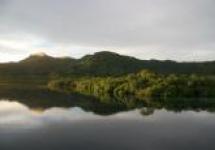
The main attraction of Indonesian Kalimantan is the extraordinarily beautiful nature of the subtropical jungle that grows along the main river Kapuas.
How to get to Kalimantan
Many Indonesian and international airlines fly to the airports of the island of Kalimantan. The main airports are located in the cities of Balikpapan, Banjarmasin and Pontianak. The flight from takes from one and a half to two hours, and from - about one and a half hours. The air ticket price is 480,000-595,000 ind. Rupees.
It is possible to move by sea between the islands of the state of Indonesia using a ferry, but this will take at least two days.
From Pontianak there are ferries to Jakarta (45 hours by sea) and to Semarang (48 hours). Ferries also depart from the port of Sampit to Surabaya (30 hours) and from the port of Kumai to Semarang (28 hours). The island of Sulawesi can be reached from the city port of Balikpapan (20-26 hours).
Major cities of Kalimantan
Banjarmasin
Banjarmasin, the administrative center of South Kalimantan, is interesting for its urban architecture and numerous canals. The symbol of the city is the Sabilal Mukhtadin Mosque with high minarets. Floating markets can often be seen on the Barito River and on the adjacent river channels. Not far from the city are the Diamond Mines, where precious stones are mined.
Pontianak
The capital of West Kalimantan, Pontianak, is often called the "city of the equator" because it is located on the equatorial line of the Earth. This is evidenced by the Monument installed on the central city square.
Among the important architectural objects of Pontianak are the Kadriakh Sultan Palace, the Abdurrahman Mosque, the Museum of Porcelain and Ceramics, the City Museum with an interesting exposition dedicated to the culture of local tribes (including the Dayak tribe).
Samarinda
Samarinda, the central city of the Indonesian province of East Kalimantan, is located in the Mahakam River Delta. The city is famous for its buildings on rafts and piles. It is also a major commercial port.
Balikpapan
Of port city Balikpapan regularly leave ferries and ships to the neighboring island of Sulawesi and beyond. There are several hotels and diving centers on the city beaches.
Sights of Kalimantan
The island of Kalimantan is kept away from the developing civilization. No ancients to be found here historical monuments and resort entertainment.
The indigenous people of the Dayaki Island stubbornly adhere to their traditions. Culture, customs and traditional crafts can be learned in the Dayak villages (in the western part of the island).
The splendor of tropical nature, the uniqueness and diversity of flora and fauna are revealed in numerous national parks (Kayan Mentarang, Sebangau, Tanjung Puting and others), scattered across the island of Kalimantan.
Kayan Mentarang National Park is a sanctuary for many species of birds, monkeys, predators and reptiles.
Gunung Palung Park, together with the Kebun Raya Sambas area, is a unique ecological area representing the world of flora and fauna from coastal waters and wetlands to relic mountain forest.
Entertainment in Kalimantan
Kalimantan Island attracts amateurs active rest... The vastness of the seas surrounding the island, with a rich and varied underwater world - beautiful place for fans of diving.
The turbulent rivers of Kalimantan promise an interesting boat and raft trip.
Connoisseurs of pristine nature and conquerors of the wild jungle will also find something to do here. 70% of the area of \u200b\u200bKalimantan is impenetrable jungle.
Kalimantan is the third largest island in the world and the only offshore island in three countries. States on Kalimantan: Indonesia, and Brunei. Another name for the island of Kalimantan is Borneo. The name originates from the Sultanate of Brunei, next to which the ships of Magellan anchored. Subsequently, Magellan's expedition extended this name to the entire island in the form of "Borneo" (the word means "ocean").
In contact with
Climatic features of the island of Kalimantan
 The area of \u200b\u200bthe island is 748,168 km². Capital - the city of Kota Kinabalu... The economy is dominated by oil and diamond production. Tourism brings a significant share of the profit to the state.
Kalimantan is in the equatorial climatic zone, all year round the climate here is warm and hot. The average temperature is from +27 ° С to +32 ° С, it is a little cooler on the territory of the Kelabit mountain plateau.
A lot of precipitation falls here every year - up to 3000 mm, and in the mountains - up to 5000 mm. Tropical showers do not prevent tourists from enjoying the beauty of the island, as they usually pass at night.
Tourism in the country
 The island can be divided into several geographic areas. The central region belongs to. Here the mountainous terrain is adjacent to forests, rugged jungles and swampy rivers.
Unfortunately, tourists cannot find near the inhabited territory beautiful landscapes and virgin forests, all this can be seen only in places where it is practically impossible to reach. Locals do not care much about their ecological heritage and have spoiled it. Therefore, tourists are recommended to visit the territory of the island belonging to Malaysia. The western part of the island is located in the equator zone. She is reputed to be the most virgin, little explored. There are few tourists here, mainly researchers and scientists come to the island.
Borneo ecoregions deserve special attention... There are swampy peatlands, which are a secluded ecoregion of the island, and lowland, mountain rain forests. The rainforests located on the Kalimantan plain are tropical broadleaf forests - a huge number of plant species and about 450 bird species.
In the central part of the island, there are mountain rain forests 1000 meters above sea level. Hiking tours are regularly organized here.
The main flow of tourists comes to Kalimantan for the sake of beach holiday and diving. Borneo resorts receive tourists all year round, but during the monsoon period there are few visitors. The inhabitants of the island represent different cultures, which is why the local cuisine is so diverse. Thai, Indonesian, Chinese and other cuisines of the world are presented in local cafes and restaurants. The dishes are quite varied, with bright decorations and lots of spices.
Local Attractions
An unforgettable Borneo experience is guaranteed. Wildlife, jungle, unique animal world - the main attractions of the island. Some representatives of flora and fauna live only here. In the forests you can see leopards, rhinos, elephants, nosed monkeys and other animals that you will not find anywhere else.
Famous places of Borneo:

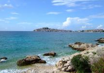
Borneo beaches
Throughout the year, the water in coastal waters reaches levels from +25 ° С to + 30 ° С. Almost all beaches are covered with fine white sand, the shores are buried in thickets of luxurious tropical greenery. There are no big waves here, the coral reefs protect the coast from them.
The island's coastline attracts diving enthusiasts from all over the world.
All tourists note that Borneo has amazing sunsets. The beaches here are great for a quiet and relaxing holiday.
From the territory of the Sabbah beaches on the horizon you can see many tiny islands, any tourist can get to them by motor boat or boat.
Most tourists prefer to rest on the Malay territory of the island. Malaysia is a Muslim country, it will be quite useful to get acquainted with some of the traditions of this people:

Do not ignore the signs prohibiting swimming, which are installed on some parts of the beach. There are many poisonous sea creatures off the coast of Borneo, you should not endanger your health.
Relief. Geological structure and minerals
Kalimantan, Borneo, an island in the Malay archipelago, the largest of the B. Sunda Islands. Pl. 734 thousand km 2 (the second largest on Earth after Greenland), with coastal islands - 746.5 thousand km 2; length from the south-west to S.-V. OK. 1100 km. It is washed by the South China, Sudu, Sulawesi, Yavan, Makassar and Karimata straits. Most of Kalimantan (about 540 thousand km 2) is the territory of Indonesia, in the north is the territory of Malaysia (Sarawak and Sabah) and the British colony of Brunei. Coast preim. low-lying, swampy, slightly dissected; good harbors are few. The sea is shallow along the western shores, along the east. the coast is in places a barrier of coral reefs. In the northwest - a section of the ancient pre-Mesozoic Sunda platform, in the south and east - the area of \u200b\u200bMesozoic and Alpine folding. The central part of Kalimantan - blocky mountains (2-3 thousand meters high), radially diverging to the outskirts. In the north - the highest point of Kalimantan, Kinabalu (4101 m). The mountains are composed mainly of granites, gneisses, and crystalline schists. Smooth peaks and steep slopes prevail. The mountains are surrounded by a strip of hilly plains that turn into flat swampy lowlands. Mineral resources in Kazakhstan include oil and coal, as well as ores of iron, manganese, chromium, molybdenum, copper, and other metals. Borneo is located at the equator; most of the island is covered with tropical rainforests, which in the higher areas turn into mountain moss forests, occupying a large area, and in the coastal lowlands they are replaced by freshwater swampy forests and mangrove thickets.
In the west and south, Borneo is washed by shallow seas no more than 60 m deep to the north and east of the island, the continental shelf is very narrow and the seabed drops steeply to a depth of 3,500 m.
Geological structure and minerals. Most of the island of Kalimantan belongs to the area of \u200b\u200bMesozoic tectogenesis. Tectonic activity persists, as evidenced by intense volcanic activity, increased seismicity (the presence of deep-focus earthquakes) and large gravity anomalies. In geol. The structure of Kalimantan includes metamorphic rocks, Paleozoic, Mesozoic and Paleogene-Neogene effusive-sedimentary deposits of various compositions, as well as anthropogenic volcanic formations. Intrusive rocks of felsic, basic, and ultrabasic composition are of Mesozoic, Cenozoic and, less often, Paleozoic age. The characteristic elements of the modern geological structure of the island of Kalimantan are island arcs and associated deep-sea oceanic trenches.
Corals developed strongly on the eastern edge of the platform, parallel to the eastern coast of Borneo and in the Makassar Strait, where there are powerful reefs, the size of which is similar to the Great Barrier Reef on the eastern edge of the Sahul Bank. These areas are favorable for corals, as they are washed by the warm equatorial current reaching the coast. The spread of coral structures in the west of the continental shelf is hindered by slight upward movements of water that form behind coastal currents.
In general, in the "Mediterranean seas" coral structures are less common, but more diverse in shape. In this zone, there are atolls, barrier and coastal reefs, located either above or below sea level, or in an inclined position to it, differently bordering the protruding islands.
This morphological diversity is explained by the location of these structures in the zone of constant and repeated displacement of geoanticlines that form island arcs.
Several theories exist to explain the formation of coral structures. They all proceed from the study of the conditions necessary for the life of polyps, which are typically coastal organisms. These theories explain the shape and size of the accumulation of coral skeletons by changing water levels. In the seas South-East Asia there are examples of coral formations supporting theories based on sea level changes or eustatic movements, especially characteristic of the Sunda Platform, as well as examples of coral structures associated with secular fluctuations of the earth's crust, which owe mainly their origin to the islands of the "Mediterranean seas", and and, finally, theories explaining coral structures by underwater tectonic phenomena.
Mineral resources: oil associated with Neogene sediments; coal in Paleogene-Neogene sediments (Sumatra and Kalimantan); yellow laterite ores (Kalimantan and Sulawesi); manganese (volcanic-sedimentary ores in Paleogene sediments in Java); tin ores (large deposits associated with Mesozoic granites on the islands of Banka, Belitung, Sinkep, etc.); aluminum (in laterite bauxite and bauxite-like rocks of Bintan Island, etc.); nickel (in the laterite iron ores of Sulawesi). Cave formations in Java contain phosphates.
Climate
On the island of Kalimanta, the climate is equatorial, on the rest of the peninsula, it is subequatorial monsoon. On the plains average monthly temperatures air fluctuates in the range of 25-28 ° C. During the day, the temperature rarely rises above + 32 ° C, and at night it drops to about + 21 ° C. The climate is temperate in the mountains, and cool at high altitudes.
The average annual precipitation on the plains is 1500–2500 mm in the peninsular part of the country and 3750 mm on the island of Kalimantan, rising to 4000–5000 mm in the mountains. Precipitation falls all year round, but as a result of the alternation of the northeastern and southwestern monsoons, they show seasonal variability (the wettest month is December, and the precipitation is less abundant from February to June). The climate is equatorial. The air temperature in the plains throughout the year is 25-27 0 C; the annual amount of precipitation is 2000-3500 mm (in the mountains up to 5000 mm), falling evenly throughout the year. East. the coast has a dry season (1 - 3 months). The river network is dense, the rivers are full-flowing throughout the year. The rivers Kapuas, Barito, Mahakam are navigable for several hundred kilometers from the mouths; on the plain, there are frequent changes in channels, swamping of the banks, in the estuaries - shoals and bars. The average monthly air temperature at sea level corresponds approximately to the average annual temperature of + 26-27 ° С.
Although not so high and more differentiated air temperature indicators are recorded in the upland regions of the island, its monthly values \u200b\u200bremain stable. Frosts occur at altitudes above 1500 m. The seasonal and spatial fluctuations in the amount of atmospheric precipitation are more significant, since the island of Sumatra is located in the zone of influence of monsoons. Most of the island receives precipitation from December to March when the western monsoon blows. From the center of origin, the western monsoon rushes over the expanses of the South China Sea towards northeastern Sumatra, northern Kalimantan and Sulawesi.
Then the air current, changing course, crosses the equator and invades from the northwest and west-northwest into the southern regions of Indonesia. The eastern monsoon, which blows from June or July to the end of September, originates in the arid inland regions of Australia. A warm but dehydrated air mass moves over the Lesser Sunda Islands and the eastern half of Java. Passing over the Indian Ocean, the monsoon begins to turn to the southwest, on the way it is abundantly saturated with moisture and rains heavy rains on the mountainous southwest coast of Sumatra.
Almost throughout the entire territory of Kalimantan, within 5 ° on both sides of the equator, an average of 1,800 to 3,500 mm of precipitation falls annually, in some mountainous regions - up to 6,100 mm per year. In general, more precipitation falls on west coast about. Kalimantan and in the mountainous regions of West Java, Kalimantan, Sulawesi and Papua. Although the distribution of precipitation is uneven by month and by region, none of them has a long dry period.
In such a monsoon-prone country with a difficult topography and peculiar configuration of islands, local weather anomalies inevitably arise. For example, the city of Palu, deep in a long and narrow bay in the west of Sulawesi, is located only 1 ° south of the equator, but in the rain shadow and therefore receives no more than 530 mm of precipitation annually. At the same time, the annual precipitation rate in the city of Padang, located at the same geographical latitude, but at the foot of the slope of the Barisan mountain range on the island, windward with respect to the southwestern monsoon. Sumatra is 4200–4500 mm.
Water resources. Soil resources
Climate and relief features favor the formation of a dense river network. Due to the abundance of atmospheric precipitation, the rivers are full-flowing almost all year round and play an important role in the irrigation system. In mountainous areas, rivers represent a potential source of electricity. At the same time, floods are frequent in the region, and rivers carry a significant amount of silty material, which complicates navigation and is deposited in the coastal zone. The largest rivers about. Kalimantan - r. Kapuas, or Kapuas Besar (1040 km, basin area - 97 thousand sq. Km) in West Kalimantan, Mahakam (715 km) in East Kalimantan, Martapura and Barito (650 km) in South Kalimantan. Most of the rivers originate in the central mountain range; on the plains, closer to the coast, they flow through vast swamps; the channels change frequently. Settlements are formed along many rivers, which also serve as transport arteries. Coastal zones swampy in the north. Most of them are of tectonic or volcanic origin. There are floodplain lakes teeming with fish. Other largest lakes: Djempang, Melintang and Semayyang - on the river. Mahakam, Kalimantan; and Loire, Centarum and Siavan - on the river. Kapuas, Kalimantan.
In the lowlands, runoff conditions are difficult due to the abundance of precipitation, low evaporation and dense vegetation cover. There, huge swampy areas are formed, which often impede the economic development of the area. Frequent floods caused by heavy rainfall also contribute to waterlogging. The level of the rivers of the island of Kalimantan almost does not change during the year. Most of the islands' rivers are short. The largest of them - Kapuas, flowing in Kalimantan - reaches 1040 km.
In the upper reaches of the rivers have large reserves of water energy, in the lower reaches they are used for irrigation and navigation. Most of the marshes are flooded every rainy season, while wide deltas and coastal strips up to 20 km wide are flooded twice a day during high tides. Although the rivers crossing the marshes are navigable for some extent (this depends on the shifting sandbanks), villages are rare and separated from each other by great distances. Some channels off the coast are extremely deep, probably by a tidal wave, for example the Kampar River. Navigable rivers form transport arteries running from east to west; in the interior of the island, near the foothills, they meet with a highway and a railway, stretching from the northwest to the southeast.
Soils. Strongly leached podzolized lateritic soils on a thick weathering crust predominate. With the exception of the arid southeast of the country, which is dominated by the reddish brown soils of dry savannahs, soils in the rest of the country tend to experience more or less lateization, characteristic of areas of very humid tropical climates. Such red-yellow ferralite soils of low-lying areas are quite suitable for the growth of dense tropical rainforests, as well as rubber plants and oil palms. IN coastal areas and in the plains, alluvial and tropical bog soils are especially widespread, and in mangrove forests, mangrove saline soils. The most fertile soils of the island of Kalimantan are of volcanic origin. On the prevailing acidic igneous rocks, soils of average quality are formed, more fertile soils are formed on rocks of average composition.
Such soils are found in the east and central part of Java, Bali, as well as on the Batak plateau in the vicinity of Lake. Toba in Sumatra. Thus, the most suitable soils for agricultural use were formed on volcanic rocks redeposited by watercourses, mainly in the valleys of the middle and lower reaches of rivers in east and center of Java, south Bali and northeast Sumatra. Fertile soils, formed directly on lavas of average composition, are found in many areas of the archipelago, but their areas are small. Mountainous regions are also characterized by mountain ferralite red-yellow soils, red soils and yellow soils. In Kalimantan, mainly red-yellow ferralite and alluvial soils are widespread, which, under the influence of heavy rainfall, are eroded and lose their fertility. In many areas, once fertile soils are depleted due to the continuous cultivation of the same crops. The soil and climatic conditions of Malaysia are very favorable for the development of dense tropical rainforests. Forests cover about 70% of the country's territory. Most of them are common in Kalimantan. The tropical rainforests are biodiverse.
Vegetation. Animal world
Vegetation.
More than 3/4 of the territory. K. is covered with forests; along the sea. shores - mangrove vegetation. On the plains and in the foothills there are tall multi-tiered tropical rainforests of palms, bamboos, pandanus, and multi-trunk ficuses. Until the exit. 1500 m - the most lush mountain forests of dipterocarp, sandalwood, ficus, rasamal. Trees are often intertwined with lianas, epiphytes, including abundant mosses. Above are evergreen oaks, laurels, rhododendrons, conifers (Bornean agathis). On the tops of the mountains, there are shrubs and forb meadows. In the south-east As a result of felling, shrubs and thickets of Alang-Alang and wild sugar cane dominate. Due to the hot and humid climate, the variety of relief, as well as geographic location Indonesia has a rich and varied floraincluding approx. 40 thousand species (only Java has about 10 thousand species). With the exception of Java and Bali, approximately 90% of the country's territory is covered with forests, which grows approx. 3 thousand species of trees. To a large extent, this is already a secondary forest (belukar), which is quite common in those parts
The accumulation of silt sediments on the coast creates conditions for the formation of mangrove swamps with evergreen thickets. A sandy seashore free of such sediments looks completely different, with a beach fringed with a variety of salt-tolerant flora, including graceful casuarins and coconut palms. In elevated areas at altitudes of 450-900 m, plants of the temperate zone prevail, and at altitudes of more than 1500-1850 m they are replaced by mountain gilea, or a mossy tropical forest with a predominance of evergreen (oak), broad-leaved (oak, beech, chestnut) and conifers (bornean agathis, podocarpus) breeds. This belt is also rich in orchids, ferns and mosses. On the mountain tops, above 2500–3000 m, mixed forests give way to thickets of bushes (mountain casuarina) and alpine meadows.
In flood-free places from sea level to an altitude of about 1500 m, the richest tropical rainforests with a complex system of tiers, with an endless number of lianas and epiphytes, are spread along the mountain slopes. The tallest trees, which include palms, ficuses, legumes, reach 60-70 m in height. Valuable fruit trees of the forests of Kalimantan - bread, mangosteen, mango, duryan - are widely cultivated not only on the islands of the Malay Archipelago, but also in other parts of the tropical belt.
Bananas, bamboos, pandanuses, giant ferns grow in the lower tiers. Orchids, mosses and lichens live on the trunks of fallen trees and on the soil. Numerous lianas, including the famous 200-300-meter rattan palm tree, entangle this already impenetrable thicket. During the rainy season (there are two of them, coinciding with the equinox periods), streams of water sometimes fall from the sky for whole weeks without interruption, accompanied by thunderstorms and squalls. The microclimate of the lower tier of the tropical forest is distinguished by a particular constancy and stability of its elements. The evergreen vegetation of the jungle is multi-tiered. The first tier is made up of single perennial giant trees up to 60 m high with a wide crown and a smooth trunk devoid of twigs.
The second tier is formed by trees up to 20-30 m high. The third tier is represented by 10-20-meter trees, mainly palms of various types. And finally, the fourth tier is a low undergrowth of bamboo, shrubby and herbaceous forms of ferns and lyes (evergreen spore herb).
There are two types of rainforest - primary and secondary. The primary tropical forest, despite the many arboreal forms, lianas and epiphytes, is quite passable. Dense thickets are found mainly along river banks, in clearings, in areas of felling and forest fires.
At the same time, the dense crowns of trees prevent the penetration of sunlight to the soil and its drying out. Only a tenth of the sunlight reaches the earth. Therefore, a damp twilight constantly reigns in the tropical forest, creating the impression of gloom and monotony.
For various reasons - fires, felling, etc. - huge areas of virgin rainforest have been replaced by secondary forests, representing a chaotic heap of trees, shrubs, vines, bamboo.
Animal world. Kalimantan has an extremely rich and varied fauna: elephants, large monkeys (orangutan, gibbons, nosed monkey), half-monkey fat loris, woolly wings, bats (fruit-eating bats, insectivorous bats), bears, two-horned rhinoceros, about 600 species. birds, among them hornbills, argus, parrots, etc. Excludes, rich in fauna of insects and other arthropods. A conventional line drawn by an English naturalist of the 19th century. AR Wallace along the outer edge of the Sunda continental shelf, east of Kalimantan and Java, corresponds to the approximate border of the Asian fauna in the west and the Australian fauna in the east. Accordingly, such large animals as an elephant, a rhinoceros (one-horned in Java and two-horned in Sumatra), a tiger and an orangutan live to the west of the designated border, and smaller monkeys are found to the east - on the islands of Sulawesi and Timor.
Many Asiatic species of birds, reptiles and insects (including butterflies) penetrate further east. As the distance to the east of this line increases, the number of Australian animal species increases, which is primarily noticeable in the province of Papua, which is characterized by marsupials.
The advance of civilization led to a significant decline in the populations of large mammals. Many animal species are endemic. For example, the Malay bear lives only in Sumatra and Kalimantan, the wild bull - in Java and Kalimantan, the dwarf bull anoa - in Sulawesi, the wild pig of babirus - in Sulawesi and Moluccas, the "nosed monkey" - in Kalimantan. Wild elephants are now found in Kalimantan and Sumatra. Kalimantan has more large mammals (tigers, panthers, rhinos, tapirs, orangutans) than any other island in Indonesia. Kalimantan is home to rhinos, tapirs, leopards and orangutans. There is a black gibbon monkey in Sumatra. In Java, in addition to the extremely rare tiger, the most famous local representative of large mammals is the wild bull, or banteng. Of the smaller mammals, the Tupai semi-monkeys are characteristic of Indonesia, and of the bats family, the Kalong flying fox (the largest bats with a wingspan of up to 1.5 m) and Kalelavar. Placental mammals, pangolins, covered with a scaly shell are of interest. In the eastern regions there are echidnas, some types of couscous and tree kangaroos, an anteater. In most parts of Kalimantan, snakes and crocodiles are widespread, and the small Komodo island, lying between the islands of Sumbawa and Flores, is home to a giant (up to three meters long) lizard - the Komodo monitor lizard.
Other species of lizards also live (agamas, geckos, iguanas, toke, etc.). Orangutan and Komodo monitor lizards are found only in Indonesia. The avifauna is unusually rich, represented especially widely on the islands of the southeast by such extremely exotic and variegated birds as the bird of paradise, peacock, hornbill, cassowary. Added to this is a truly endless variety of parrots of all sizes and the Manyar bird, which causes great damage to rice crops. Indonesia is replete with insects, including termites, ants, grasshoppers, and beetles.
The marine fauna of the coastal waters is very diverse. The seas are home to thousands of species of ornamental and commercial fish (anchovies, gobies, flying fish, sardines, mackerel, tuna). The coastal waters are full of sharks - from small to very large, dolphins, sea turtles and rays. There are sawfish, swordfish, barracuda, and others. Among the freshwater fish, there are various carp, catfish, and carps. The tropical forests of Kalimantan are inhabited by numerous animals that have adapted to the conditions of existence in a dense and shady forest. The lifestyle of most of them is somehow connected with trees, they climb trunks and branches, plan when jumping from tree to tree. Many animals nest in hollows, fallen decaying foliage, under tree roots. The forests of Kalimantan give shelter to the "forest man" - the orangutan, numerous gibbons and thin-bodied monkeys. Of the semi-monkeys, thick lorises are characteristic, the ghost tarsier (Tarsius spectrum) - small animals with huge bulging round eyes and highly developed limbs adapted for climbing trees. Various feline predators are widespread, including the tiger. The elephant, rhino, and black-backed tapir are rarely seen. Forest birds are diverse and richly represented. There are dozens of species of snakes, lizards, turtles.
The territory of Kalimantan belongs to the Indo-Malay zoogeographic region. In recent years, with the destruction of forests, the number of wild animals, especially large ones, has been reduced. Elephants, gaura bulls, Sumatran rhinoceros, tapirs are not numerous. Sambur and muntjac deer are widespread, there are many wild boars, and a bearded pig can be found in swampy forests. Among the predators in the forests are tiger, leopard, black panther, marten. There are many monkeys in the forests: orangutan, four types of gibbons, several types of macaques, lorises. There are lemurs, bats are numerous. In total, about 240 species of mammals are found in the forests. The richness of the avifauna of Malaysia is striking, with about 600 species belonging to 70 families. Its most prominent representatives are peacocks, wild chickens, pheasants, myna, white-eyed, woodpeckers, kingfishers, blackbirds, quails, parrots and parrots, wild pigeons, Malay crow and others. In Malaysia, there are 25 species of turtles (including the green sea turtle, which breeds offspring on the northern coast of Kalimantan), more than 100 species of lizards, 17 species of snakes (including the cobra, or spectacled snake, king cobra, reticulated python). Crocodiles, once abundant in river mouths, are now on the verge of extinction, and gavial is rarely found. The fauna of insects is especially numerous (about 150 thousand species, including 1000 species of butterflies).
Malaysia's coastal waters are home to hundreds of species of fish and over 1,000 species of shellfish. Mackerel, bonito, tuna, sardines, spearfish, sea bass, flying fish, swordfish, sailfish, moonfish, barracuda, sharks, rays, anchovies, mussels, octopuses, squids, crabs, lobsters, shrimps, and large animals - sperm whales, dugongs, dolphins, sea turtles.
It is divided into two large parts - Western (mainland) Malaysia ( Malaya) occupying the south peninsula Malacca and East Malaysia (Malay. Malaysia timur) occupying the north of the island Borneoalso known as Kalimantan. Borneo - the third largest island in the world, its territory is divided between three states at once: the south belongs to Indonesia, the south belongs to Malaysia, and between the two Malay states there is dwarf state - Brunei Darussalam.
Geographical location of Borneo
Isle Borneo is in the center Malay Archipelago in Southeast Asia. 
Malay part Borneo washed South China Sea , seas Sulu and Sulawesi (Celebes Sea).
The relief of East Malaysia is predominantly mountainous, it is here that highest point countries - mountain Kinabalu (4101 m), but a narrow strip of plains stretches along the coast.
States of East Malaysia
East Malaysia is administratively divided into states Sarawak (Sarawak) in the northwestern part Borneo and Sabah (Sabah) in the north-east. Besides them there is also a small island Labuan, constituting with the surrounding islets an independent federal territory, directly part of the Malay Federation since 1984.
Both Sabah and Sarawak joined Malaysia relatively late. Historically, Borneo (Kalimantan) was ruled by a Buddhist state Srivijaya with the capital on Sumatraafter the Javanese kingdom Majapahit, then - the Islamic sultanate of Brunei, later the territory of Borneo in various ways came under the control of European trade empires - East Indian companies Britain and Holland... After the collapse of the empires, the colonies began to gain independence and were torn apart by their neighbors. The Dutch part of Borneo became part of Indonesia, and on british territories - Sarawak and North Borneo (now Sabah) were claimed by both Indonesia and the Philippines, but Great Britain transferred them to Malaysia in 1963. Malaysia had serious diplomatic disagreements with Indonesia and the Philippines, it came to a complete break in relations, which were restored only in 1966.
Sabah

For its position south of the typhoon zone, the former British colony of North Borneo, Sabah is often referred to as "The Land below the Wind". State area 74.5 thousand km 2, length coastline 1440 km. The relief is mountainous, the territory is covered with forests. The capital of Sabakh, its financial, administrative and industrial center is the city Kota Kinabalu.
Tourists are attracted by climbing Kinabalu, river cruises and rafting, visiting tribes - bounty hunters, visiting national parks and the pride of Sabakh - the orangutan nursery.
Sabah is popular as a diving destination, in the waters of the state, off the islands Sipadan, Mabul, Kapalai, Xibuan and others are a number of world-class dive sites.
Sarawak
Sarawak is often called the "Land of the Rhino Bird." Its area is 124.5 thousand km 2, it is the largest state in Malaysia. The capital of Sarawak is Kuching.
Tourists can take excursions around the capital of the state, the place where the “white rajas” - the English kings of Sarawak ruled; ethnographic tours are popular, introducing the multinational cultural heritage state; visit crocodile farms and orangutan nurseries, Sunday market and caves Niach.
Hotels
Dear Sirs!
We do not always have time to publish on our website descriptions of all the hotels with which we work. For details, contact your manager by phone. +7 495 938-92-92
Geographical position
Kalimantan (Borneo) - the third largest island in the world; the only sea island divided between three states: Indonesia, Malaysia and Brunei.
Square - 743 330 km². The island is located in the center of the Malay Archipelago in Southeast Asia.
The Indonesian large part of the island is divided into four provinces (West Kalimantan, Central Kalimantan, South Kalimantan and East Kalimantan). The Malaysian part is divided into two states - Sabah and Sarawak.
Kalimantan is surrounded by the South China Sea, the Sulu Sea, the Sulawesi Sea, the Makassar Strait, the Java Sea and the Karimata Strait. To the west is the Malacca Peninsula and Sumatra Island. To the south is the island of Java. To the east is the island of Sulawesi. To the northwest are the islands belonging to the Philippines.
The highest point on the island is Mount Kinabalu in the Malay state of Sabah with a height of 4,095 m. In the same part of the island is the active volcano Bombalay.
How to get there
 The easiest way to get to Borneo island is by plane from Kuala Lumpur. And then there are 2 options.
1. Fly to the state of Sabah. Flight Kuala Lumpur - Kota Kinabalu. By time - 2.5 hours
2. Fly to the Sarawak Sultanate. We need a flight from Kuala Lumpur to Kuching. Time approximately 1.5 hours
Visa
To enter Indonesia, citizens of the Russian Federation for up to 30 days do not need a visa in advance to apply for a visa. The visa can be issued upon arrival at international airports, seaports and border checkpoints.
Climate
 The island has a tropical climate with very high rainfall throughout the year. The air temperature ranges from 29 ° С to 34 ° С, and the air humidity reaches 95-98%.
If you decide to visit this wild part of the planet, plan your trip from September to March, when the air temperature is slightly lower.
Population
 The population lives mainly on the coast and in cities.
In the interior, small towns and villages occupy territories along rivers. The population consists mainly of the Malays, Chinese and Dayak ethnic groups. The Chinese originally migrated from southeastern China. The majority of the population in Kalimantan is Muslim. About 15% of the Dayaks are Christian, and the religion was introduced by missionaries in the nineteenth century. There is a minority of Hindus in Central Kalimantan. In addition, the Punans live in Borneo, who sacrificed part of the nomadic life of hunter-gatherers. In some coastal areas, the Bajau are a "minor point", which have historically been associated with the sea and the nomadic life of the boat house In the northwest of Borneo, the Dayak ethnic group is represented by around 710,000 members.
Kalimantan has been the focus of a funded program to intensively relocate landless poor families from the islands of Java, Madura and Bali. In 2000, transmigrants made up 21% of the population of Central Kalimantan. In the 1990s, a military conflict broke out between some settlers and the indigenous population.
Nature
 The highest point on the island is Mount Kinabalu in the Malay state of Sabah, 4,095 meters above sea level. This makes Borneo the third tallest island in the world. The active volcano Bombalay is located in the same part of the island.
File 14036 The World Wildlife Fund divides the island into 7 different ecoregions. Rainforests cover most of the island of Borneo, covering an area of \u200b\u200b427,500 square kilometers. Other ecoregions are the Borneo Peatland Lowland Forests, the Kerang Sunda Forests, the Southwest Borneo Freshwater Marshes and the Sunda Shelf Mangrove Forests. The mountainous rainforests of Borneo in the central mountainous regions of the island are higher than 1,000 meters. Mount Kinabalu is home to numerous endemic mountain meadow alpine plants, including many orchids.
File 2307 Borneo is known for its rich biodiversity of flora and fauna. The island has about 15,000 species of flowering plants and 3,000 species of trees, 221 species of land mammals and 420 species of resident birds. Considering the massive deforestation in Borneo, which is the natural habitat of the endangered orangutans. Borneo's forests are home to many endemic animal species such as the Asian elephant, Sumatran rhinoceros, clouded leopard, and fruit bats. The island of Borneo is one of the most biologically diverse places on earth. World Wildlife Fund said 361 species of animals and plants in Borneo have been discovered since 1996, highlighting its unprecedented role in preserving biodiversity on the planet.
 The island is located in the humid equatorial zone and is densely covered with jungle. However, the procurement of firewood dramatically reduces the supply of wood. The jungle also suffers from forest fires during dry periods, especially severe fires occurred in 1997-1998, which could lead to an environmental disaster.
In addition, deforestation for oil palm plantations in last years acquired catastrophic proportions. Along with the felling of trees, the unique flora of Kalimantan and its fauna, deprived of their natural habitat, are being destroyed. Palm oil is obtained from the fruit of the oil palm, which is used in the cosmetic and food industries.
File 13991 Forest biodiversity continues to be destroyed further by the construction of hydropower plants and mining.
The island has rich oil fields, the production of which forms the basis of the economy of Brunei and is one of the fundamental articles of the Indonesian economy. In addition, diamonds are mined on the island.
Kalimantan is crossed by two rivers with the same name - Kapuas. One of them, in the province of West Kalimantan, is the most long river Indonesia (1143 km) and the longest island river in the world. Another, in the province of Central Kalimantan, is much shorter (about 600 km), a tributary of the Barito River.
Hotels, hotels, prices
 Kharisma Hotel 1 *
general description
The Kharisma Hotel is located in Banjarmasin making it one of the best hotels to stay at while in town. All 52 of the hotel's guestrooms are equipped with standard amenities to ensure your maximum comfort. Check-in after 14.00 check-out before 12.00
In hotel rooms
Room Service, Air Conditioned, Mini Bar, Cable / Satellite TV, TV, Desk, Shower
Hotel infrastructure
Parking, Concierge, Dry Cleaning, Laundry service
Sports and leisure
Restaurant, Garden, Coffee Shop / Cafeteria.