Underwater ruins at the bottom of Lake Titicaca (Bolivia)
Ancient megalithic structures appear to be fairly widespread at the bottom of Lake Titicaca in Bolivia.
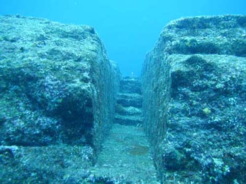
In the 60s of the XX century, scuba divers of the Argentine Swimming Federation managed to find at a distance of 250 m from the shore of Lake Titicaca a whole architectural ensemblestretching for more than a kilometer. First, the Argentine Avellaneda found an alley of stone slabs several hundred meters long, running parallel to the coast. Later, scuba divers stumbled upon walls as tall as a man's height. They were located at a distance of approximately 5 m from one another, and so on in 30 rows. The walls rested on a common foundation of huge stone blocks.
In 1980, the famous Bolivian explorer of pre-Columbian cultures, Hugo Boero Rojo, announced the discovery of ruins at a depth of 15 to 20 meters off the coast of Puerto Acosta, near the Peruvian border on the northeastern shore of Lake Titicaca. At a press conference, he stated: “We found a temple built of huge stone blocks, with no one knows where leading stone roads and stairs, the bases of which are hidden in lush thickets of seaweed”... Boero Rojo dated these monumental ruins to the time of Tiahuanaco's rise.
In early 2001, the Italian scientist Lorenzo Epis confirmed the presence at the bottom of the lake. Titicaca remains of the ancient city. In August 2000, an international archaeological expedition (according to other sources, a group of Italian divers and archaeologists) discovered ruins in Lake Titicaca at a depth of 30 m ancient temple 200 mx 49 m, a pavement, a 790 m long wall, terraces for growing crops and a stone sculpture of a human head reminiscent of the stone sculptures of the city of Tiahuanaco. According to local legends, the city of Wanaku is located at the bottom of the lake.
Described by G. Bellamy ancient coastline on the Altiplano plateau, is located below the Titicaca level (he considers it the most ancient), as well as the geological history of the plateau, which indicates that reservoirs existed on it at least until the beginning of the Quaternary period (2.6 or 1.8 million BC). years ago, according to different stratigraphic schemes), and most likely before the beginning of the Pliocene neogene period (5.3 million years ago), and maybe even earlier.
Lake Titicaca currently has a salinity of about 1%, it is home to the relict ocean seahorse Hippocampus, and Tiahuanaco has images of flying fish characteristic of tropical seas... That is, there are all the signs that Lake Titicaca is a relict, never dried up sea basin, which over its long history has turned from a salty sea bay or strait into an almost fresh lake. This means that the underwater city of Wanaku (and the ruins found at the bottom of the lake) could hardly have been built later than the end of the Neogene period (2.6 or 1.8 million years ago). Unless, of course, it was not built by the civilization of amphibious people. Although, as in all other cases, the dates of the construction of this complex are given from several thousand to 12-15 thousand years ago.
Underwater pyramids at the bottom of the Rock Lakes (USA)
Rock Lake is located 40 km east of Madison, Wisconsin, USA and is about 8 km long and 4-5 km wide; the bottom of the lake is muddy and therefore its waters are always muddy. A suspension of the finest silt falls off only during cold and clear days. It is believed that the lake was formed as a result of filling the basin with waters of retreating glaciers from 10 to 12 thousand years ago.
At the bottom of Lake Rock, under a 12-meter (according to other sources, 40-meter) water column, more than a dozen small pyramids (most often called the number 13) with flat tops were discovered. They are stacked in stone blocks weighing 2 to 5 tons, carefully fitted to each other. Such pyramids were previously known only in Mexico and Guatemala.
The pyramids are arranged in a crescent at the same distance from each other. Among them there are pyramids with trapezoids not very elongated horizontally at the base with sides up to 20 m long and pyramids with almost square bases with sides 9-10 m long.They rise above the muddy bottom of the lake to a height of 3 to 8 m. The main pyramid is located in the center of the lake and reaches 9-10 meters in height (according to other sources, in the center of Lake Rock are the ruins of an ancient observatory, strictly oriented to the cardinal points). But since the bottom of the lake is muddy, it is difficult to say what the exact height of these structures is. Different researchers estimate the age of the pyramids from 12 to 17 thousand years.
In addition to the pyramids at the bottom of Lake Rock, destroyed houses, the ruins of a large arch, stone embankments and breakwaters were found. A whole sunken city.
A Brief History of the Discovery and Exploration of the Rock Lake Pyramids
In April 1936, in clear weather, dentist Morgan, flying over the reservoir in his sports plane, accidentally looked down - and saw the outlines of three large objects under the water surface. Morgan sank - and his eyes saw the distinct silhouettes of pyramids with truncated tops!
After this incident was reported in the newspapers, researchers became interested in Rock Lake. In the 60s. XX century a team of scuba divers descended to the bottom of the lake. The young biologist W. Kennedy was able to examine a stone wall of a structure under water. Having circled it, the scientist was convinced that the building has a pyramidal shape. He took with him a trophy - a broken piece of masonry. However, when Kennedy tried to return to the pyramid with his comrades, they failed to find it.
A few years later, in the early autumn of 1968, another group of enthusiasts arrived at Lake Rock - 10 scuba divers led by M. Kutska from Chicago. Underwater archaeologists surveyed the entire reservoir in squares - and discovered the first pyramid! The structure was of the correct shape and had a rectangular base measuring 9x10 m. It was certainly a creation human hands... Later, the researchers found another building, slightly different in parameters from the first.
Curious details were found on the first pyramid: fragments of shells of mollusks and rather large bones. As we managed to find out, the Indian city of Atzlan once existed in these places. Its inhabitants widely used mollusk shells in everyday life and, according to the custom widespread in antiquity, ate their enemies. According to archaeological excavations, Atzlan was burnt. It has been suggested that the Atzlan aborigines had something to do with the sunken pyramids.
In 2002, an amateur scuba diver Charles Stock picked up a piece of gray stone from one of the stone platforms, on which, after drying in the sun, nodular Indian letters and clear hieroglyphs were squeezed out, as on wet clay.
Diver Richard Sayton discovered almost at the very top of one of the large pyramids a breach that could not be penetrated by a person in diving equipment. Saiton gave an oath of assurance that there was "An intermediate water lock, through which, very likely, there was a dry room equipped with a manhole through which one could get into the underground."
Underwater pyramids at the bottom of Lake Fuxian (China)
Another underwater pyramid was discovered by a group of scuba divers in 2001 at the bottom of the Chinese Lake Fuxian, located in southwestern China in the Yunnan province at an altitude of 1750 m above sea level. At the bottom of the lake, at a depth of 30 m (according to other sources, 40 m), there were the ruins of a huge five-step pyramid 19 m high with a base side length of 90 m.
The mysterious structure was built from massive stone slabs weighing several tons, which formed giant stone steps. The two upper steps of the pyramid, made of sandstone, were destroyed. And the rest of the ledges, built of limestone - a harder rock, are well preserved. No entrances or openings were found in the pyramid itself. Similar pyramids are known in Central and South America, in Mexico and Peru. Scuba divers reported the find to the Archaeological Center of Kunming University in Yunnan Province.
Experts from this center, led by archaeologist Li Kunshen, with the help of sonars, found that at the bottom of the lake there are more than thirty different objects, houses, roads, columns. The head of the archaeological center suggested that these objects are the creation of some ancient civilization. total area of the studied buildings was 2.5 sq. km. The previously discovered pyramid was located in the very center of the underwater complex.
For several months, scientists studied the underwater ruins at the bottom of Lake Fuxian. However, they managed to find only one artifact. A small earthen vessel from the Eastern Han dynasty, which ruled 25-220 BC. However, the age of the pyramid and other underwater objects is likely much older.
In addition to the central pyramid, at the bottom of Lake Fuxian there are at least 9 smaller pyramids and more than 30 other medium and small structures.
In 2010, research on Lake Fuxian (in the Russian press it is called Fushian Hu, perhaps this is another lake?) Were continued by a joint Sino-Russian expedition. From the Chinese side, the expedition was organized by the archaeological group of Kunming University, the Dive Disport diving center and the underwater archaeologist Bao Ling, from the Russian side - by divers Leonid Gavrilov and Yevgeny Spiridonov.
The following is information about these studies based on an article on the site http://www.ufo-com.net (original source), which does not always agree with the data published above.
The Chinese archaeologists did not have the opportunity to reach such a great depth (in one place of the article it is said that the pyramids are at a depth of 50 m, in another - at a depth of 200 m), and also to raise evidence of human activity from there, so they invited Russian divers.
Leonid Gavrilov told about some of the details of the expedition.
- The first observations of the city were made by archaeologist Li Kunshen (2001?), Teacher of Dr. Bao Ling. Then, through the diving center, they asked to find divers capable of diving to a depth of more than 50 m. There are no specialists of such qualifications and experience in Kunming. We conducted dives, taught our Chinese colleagues the minimum knowledge in this area, took photographs of the upper part of the pyramid, found new places for diving and research, examined the island in the middle of the lake, gave an expert opinion on further underwater research, conducted a mini ethnographic study of the area around the lake, took samples from the lake and pyramids for further study by geologists in Moscow.
With the help of sonars and a side-scan locator, kindly provided by Chinese specialists, we obtained three-dimensional echograms of this and other pyramids. The shape of the pyramids is close to the Mayan culture, the size of the blocks is from 3 to 5 m, rather, to the pyramids of the Egyptian plateau of Giza - these data are also confirmed by our Chinese colleagues, - said Leonid Gavrilov.
- What we found in a freshwater lake with pyramids over 40 m high is really amazing. This is a new wonder of the world - our common world heritage, preserved thanks to water, and absorbed by water.
The area of \u200b\u200bthe surveyed ruins at the bottom of the lake exceeds the size of the capital of the Eastern Han Dynasty. The city is not mentioned in any of the famous Chinese archives or ancient manuscripts. Missing chinese city Yalunwan was supposed to be made of wood and clay, but the structures found are classic megalithic structures, surpassing the Egyptian pyramids in complexity of execution and drawings.
They have been preserved almost in their original form, and have not been touched either by time or by man. The upper part of one of the three surveyed pyramids is located at a depth of about 54 m, the lower - at 97 m. The photographs of the processed stone blocks show drawings similar to the human ear.
As we expected, Lake Fushian Hu is of tectonic origin. The approximate, very approximate age of the once surface structures is from 5,000 to 12,000 BC. The lake has been explored for one percent of its area. It is up to 7 km wide, the length of the lake is more than 30 km, and the depth reaches 180 m.
Underwater pyramids at the bottom of Lake Kinneret (Israel)
In 2003, Israeli scientists discovered a massive round stone structure at a depth of 9 m in Lake Kinneret or the Sea of \u200b\u200bGalilee (Israel) using an echo sounder. It has the shape of a cone with a base diameter of over 70 m.
In 2012, the results of the first studies of this strange construction by scientists were published. Archaeologist Dani Nadel from the University of Haifa spoke about them in an article published in the International Journal of Marine Archeology.
The discovered underwater structure is an asymmetrical, fish-infested cone of basalt boulders located at depths of 1.5 to 13 m, approximately 500 m from the southwestern shore of the lake. The base of the dome is covered with sediments. According to D. Nadela, this stone structure was made by people from basalts located near the lake. Kinneret. He estimates the weight of the entire structure at 60,000 tons.
Yitzhak Paz, an archaeologist with the Israel Antiquities Society, who also participated in the research, suggested based on the history of sedimentation in the lake. Kinneret that this underwater structure is between 2,000 and 12,000 years old. The purpose of this design is still a mystery. It could be a burial place, a cult object, and even a structure in which fish were bred. However, Paz has no doubts that this stone cone was built on the ground.
Mysterious underwater structures elsewhere in the oceans and seas
Strange underwater structures of a round and pyramidal shape or resembling ruins, in some cases discovered during underwater seismic surveys, in others - clearly visible on images from Space, are also located at the southern tip of about. Bimini, off the coast of Florida North Carolina, Belize, Malta, France, the Baltic Sea, a lake in the south of Laos, and many other places. In most cases, scientists do not yet know exactly what they are. According to some researchers, once these round structures were burial mounds, according to others - rounded and pyramidal structures belong to pyramids, others see ruins of some sunken cities at the bottom of the oceans and seas.
The underwater anomaly stands apart Baltic Sea, which was studied by Swedish scientists in 2012.It is a stone block about 60 m wide, covered with lines and propped up by a stone cushion 8 m high.This megalith resembles the shape and structure of the Asuki stone megaliths in Japan and the Fuerte de Samaipata stone carvings in Bolivia.
Conclusion. Underwater megalithic structures - part of the underwater-underground-terrestrial megalithic complex, covering the whole world
The above data confirm the wide distribution of megalithic structures at the bottom of oceans, seas and lakes, which have much in common with the underground-terrestrial megalithic complex I have identified (in particular, Yonaguni, Ponape, Titicaca, etc.), as well as my proposed assignment to a single underwater - underground-terrestrial megalithic complex, which composes a significant part of the continents and the bottom of the oceans, seas and lakes.
The wide spread of the Complex on all continents and the bottom of the oceans and seas gives reason to take seriously the legends of the Hopi Indians, Aztecs and many other peoples, which tell that the remnants of the previous (which existed before the "creation" of our) world were flooded with water during its death from the flood. The development of thick soot deposits on the walls of many underground structures of Israel and Turkey testifies to fires raging on the surface of the Earth and in underground rooms, which also does not contradict ancient legends and, according to the scenario of global catastrophes on Earth and Mars I reconstructed (here, here and here), confirms the hypothesis that the underground-terrestrial megalithic complex existed before the global catastrophe that destroyed the previous world, which, according to the legends of different peoples, changed the world beyond recognition. It is for this reason that the Complex is widely developed not only on the continents, but also on the bottom of the oceans and seas.
The history of the creation of underwater structures goes back to ancient times. Since time immemorial, man has built piers, dams, artificial islands for taking out into the open sea lighthouses, defensive and economic structures. Nowadays, such hydraulic engineering facilities remain the most impressive in terms of complexity and volume of work performed. This includes dams of modern hydroelectric power plants, and the latest artificial harbors, and hidden in the water column sea transport tunnels, giant water intakes and outlets.
Although until recently such structures were erected mainly in shallow water, during their creation that vast experience of underwater technical work was acquired, without which the qualitative leap in underwater technology that is taking place before our eyes would have been impossible. Perhaps, the following is especially important here: if earlier sea structures were erected from the coast or near it, now they have moved away from the coast for hundreds of kilometers, and they began to be erected under conditions open sea *. This is mainly about the offshore construction of oil and gas fields.
* (Corresponds to the English term "off-shore" - remote from the shore.)
Initially, such structures were built according to the traditional "coastal" scheme. This is how pile cities appeared in the Caspian seafields, in the Mexican and Persian Gulfs. Such designs were found to be suitable only for relatively shallow areas. At depths of about 100 m, they were replaced by production and production platforms installed at a considerable distance from each other. They are now considered the most profitable both in terms of construction and in terms of service, since they allow drilling and production in the open sea.
Stationary offshore platforms are high-rise structures; most of them are submerged in the water column. Only the working platform, raised high above sea level, remains open for observation. It houses drilling equipment, power plants, living quarters, material warehouses, lifting equipment, helipads - everything that is necessary for uninterrupted operation during several months of bad weather.
There are two types of platforms: pile and gravity. The first ones are constructed mainly of steel and are fixed on seabed with the help of piles driven to a considerable depth into the ground. The latter, for the construction of which both steel structures and reinforced concrete are used, are held in the required position by gravity. The choice of the type of stationary platform is dictated by a combination of various factors. The main ones are depth, seismic activity of the bottom, weather conditions, economy.
Steel pile structures are preferred when the sea depth does not exceed 90 m and when it is possible to transport produced oil and gas through pipes. These structures are also considered more reliable in seismically hazardous areas. In this case, they are installed at much greater depths. An example is the Hondo-type platform installed by Exxon at a depth of 225 m in a seismically active area near California. This depth, at least twice, exceeded those on which similar structures were installed earlier. The structure of the platforms is made watertight (Fig. 1.8), its weight is 12 thousand tons, the height is 259.5 m. The size of the platform at the base is 51x70.5 m, in the upper part - 13.5x51 m. The platform has eight tubular supports with a diameter of 137 , 2 cm and tubular guides at the base with a diameter of 160 cm, designed for driving piles with a diameter of 122-137.2 cm to a depth of more than 100 m. The platform structure is a spatial truss made of pipes. Its main supports used 4,000 tons of sheet steel with a thickness of 1.91 cm at the top to 4.13 cm at the base. The transverse and tubular rods consumed 5,000 tons of steel. The material has been selected with a moderate yield point and sufficient ductility so that the structure can withstand the combined loads caused by the action of wind, waves, currents and earthquakes (the latter in the installation area create accelerations up to 0.5 g).
Figure: 1.8. Steel pile platform "Hondo"
Hondo platforms are made in the form of several sections that are connected and sealed afloat at the installation site. To facilitate this operation, conical guides are provided on the split parts. Parts of the supports are first connected by means of flanges with insulating gaskets, and then welded from the inside, for which special entrance hatches and lifting mechanisms are provided to provide welders access to the joints. After being connected afloat, the lower sections of the supports are flooded with water, the platform is transferred to a vertical position and installed in a predetermined place at the bottom. The ends of the supports enter the ground to the design depth, and piles are driven into it through the guide pipes, which are then cemented or welded underwater. The designers assume that such structures can be installed at great depths of the sea. Exxon plans, for example, to install a similar platform at a depth of 312 m in the Gulf of Mexico at the mouth of the Mississippi River. The platform, weighing 45 thousand tons, will rise 54 m above sea level.
Installation of platforms on piles on the open sea is very difficult. The main one is to give the foundation the design stability in the shortest possible time. In the North Sea, where such work can be carried out four to five months a year, the final commissioning of the platform sometimes takes one to two years. There are also operational difficulties, in particular, the provision of a permanent electrochemical protection of such a grandiose structure, constant monitoring of the condition of the supports and the power set.
It is very important to correctly determine the resource of such structures in terms of the fatigue strength of materials of structural elements and strictly observe the modes of their operation. The accidents that occurred in 1980 in the Norwegian sector of the North Sea, connected with the destruction of the bearing supports of two pile platforms during storms, are a tragic penalty for the violation of these regimes.
The advantages of gravity platforms are a significant reduction in installation time (instead of months - several days), greater safety of towing of these massive structures with good stability, simplification of commissioning operations due to the fact that almost all equipment can be installed on the working deck before towing. Technological advantages such as the properties of concrete to acquire strength over time and its corrosion resistance are also important. If a significant part of the cost of work on the creation of a pile structure falls on pile driving, then the cost of work on the installation of a gravity platform is only 10% of the total cost, and most of it is used for towing. Another advantage of gravity platforms is the ability, at no additional cost, to create tanks at their base for storing mining products, which makes such structures more multifunctional than piled ones, allows them to be installed in areas significantly remote from the coast, as well as where pipelines are laid through some or the reasons are difficult. The advantages are the cheapness and availability of such building materiallike concrete.
Unfortunately, these platforms are not without their drawbacks. These include the need to carefully level the seabed before installing the platform, sensitivity to seismic loads and potential build-up of hydrostatic pressure in cavities during installation, and shock loads when installing the platform to the bottom. The disadvantages include a large draft during towing (however, the same draft increases stability and makes it possible to continue transportation in the event of a storm). However, the advantages of reinforced concrete gravity platforms still exceed their disadvantages, otherwise, how can one explain the fact that in 1976 - 1977. during the construction of oil fields in the North Sea, the demand for them was twice as high as for steel platforms. The most common type of gravity platform is a structure with a cellular container as its base. The supports that support the working deck pass through it and are fixed in the foundation slab. Tank cells combined into several groups can serve as storage for liquid and gaseous products. In the process of construction, towing and installation, the cells act as pontoons of variable buoyancy.
The first platform of this type (Fig. 1.9) "Doris" was built and installed in 1973 in the North Sea at a depth of 70 m. The platform height is 90 m, dimensions in plan are 50x50 m, it took 80,000 m 3 of concrete to make it. A wave-damping wall is installed around the platform, absorbing up to 70% of the wave energy.

Figure: 1.9. Doris-type gravity platform
One of the characteristic structures of gravity concrete platforms is a platform developed by the designers of the Akergroup concern and called Condeep. Its foundation consists of 19 cylindrical oil storage sections, on conical concrete columns protruding from the water, rests a working steel platform with an area of \u200b\u200b4000 m 2, raised to a height of 30 m above sea level (Fig. 1.10).

Figure: 1.10. Gravity platform of the "Kondip" type
The construction of such a platform begins in dry dock or in a pit on the shore. First of all, the steel formwork and the reinforced concrete base are mounted and the height of the walls of the reinforced concrete sections is increased to 6-10 m. Then the work is carried out afloat, adjusting the draft with the help of ballast. The next stage of construction - the completion of the lower block and the beginning of the concreting of the columns - is carried out in shallow water, and work is completed in the deep-water area. Here, a working deck and equipment are installed on the columns, the weight of which can reach several tens of thousands of tons. The sequence of work on the construction of the gravity base is illustrated in Fig. 1.11.

Several types of gravity platforms have been developed that combine the advantages of a reinforced concrete underwater storage facility with those of a steel truss. These are the so-called hybrid platforms. Their distinctive feature is the possibility of simultaneous construction of the three main elements of the platform at different plants and the absence of difficulties associated with towing in shallow water areas, since these elements are a bottom block containing about 160 thousand tons of oil, a steel truss and a working deck mounted directly in sea \u200b\u200b- transported separately. Steel truss can be made in the form of a single monoblock or several columns.
All-metal gravity platforms have also been developed. One of them, designed by Teknomair (Italy), is designed to drill 32 wells at a depth of 250 m (Figure 1.12). The platform is a steel truss resting on the bottom with three containers located at the corners of the triangular base. The structure is assembled onshore and transported to the installation site afloat in an upright position. Several modifications of such a platform have been created for different areas of operation.

Figure: 1.12. All-metal gravity platform "Teknomair"
One of the world's largest offshore reinforced concrete platforms is being built for the Brent field, 160 km northeast of the Shetland Islands. Its mass is 300 thousand tons, of which 259 thousand tons are specially prepared concrete, 15 thousand tons - for reinforcing steel, about 3 thousand tons - for working decks. The sea depth in the installation area is 138 m, the working deck rises above the water surface by 30 m. At the base of the platform there is a 54 m high tank, divided into sections with an area of \u200b\u200b28 m 2. The base plate area is about 11 thousand m 2.
Drilling and operational equipment weighing 6,000 tons is located on the steel working deck. Above it is a platform for helicopters. The platform is intended for drilling 36 wells, and its capacity is capable of holding about 160 thousand tons of oil.
The structures described above resist the effects of waves and surface currents. Meanwhile, with increasing depths, the dimensions of the platforms increase, the natural vibration frequencies decrease, and to ensure strength, it is necessary to resort to more and more material-intensive structures. In this regard, the developers had the idea of \u200b\u200bcreating platforms that could deviate from the vertical position under the influence of adverse meteorological conditions on the sea surface. For example, Chicago Bridge & Iron engineers proposed a design for a deep-water tower-type installation equipped with a gimbal near the base and four floating tanks in the upper part. In appearance, the platform should be a four-sided metal truss, fixed to the seabed with forty piles driven through the legs of the tower, which are somewhat short of the foundation slab. The latter is made in the form of a torus with an outer diameter of 45 m and an inner diameter of 36 m. Pipes 9.1 m long and 1.37 m in inner diameter pass through the torus body (the piles will be driven through these pipes). The space between the piles and the guide pipes (pile diameter 1.22 m) is filled with concrete.
The platform is designed for drilling 40 wells at a depth of 412 m. It is completely assembled onshore in a dry dock and is towed horizontally to the installation site. To move the platform to a vertical position, it is enough to fill its ballast tank. In the future, it is planned to create platforms designed to work at depths of up to 600 m.
With increasing sea depth in the mining area, the construction of stationary platforms is becoming more labor and material intensive. Experts believe that 300 m is the limit beyond which purely subsea drilling and operating systems become profitable. This is especially true of stormy and freezing seas. About one hundred subsea installations have already been tested and partially used in the world. These are mainly experimental systems located at a depth of 50-100 m. There is experience in installing wellhead equipment at a depth of 120 m to operate a well together with a Kondip-type platform at the Beryl field (North Sea). Systems for working at depths of up to 900 m are under development.
The construction of such structures includes the installation at the bottom of a massive base with a working chamber containing a set of drilling equipment, a supply of pipes and tools. Drilling in the chamber is carried out at normal pressure; shift personnel are delivered from a special support vessel using a standard pressure chamber. In another embodiment, the subsea base is equipped with a device for introducing a drill from the surface and a remotely controlled valve (blowout preventer) to prevent the release of oil or gas. Upon completion of drilling, the well is connected to a common distribution system (manifold), which is controlled from the production base.
In addition to the bases and platforms, mention should be made of underwater storage facilities located at the bottom and in the water column. They are intended for the accumulation of oil and gas, including liquefied gas, and various products of oil refining. Such storages can be placed in the most convenient place from the point of view of operation. With sufficient depth in them, without special costs, it is possible to maintain a constant temperature - an important factor that reduces storage losses. These storage facilities are often equipped with dedicated floating docks (Fig. 1.13), from which giant tankers can load without danger of damaging the storage facilities. In some cases, it is necessary to equip operational bases with storage facilities with floating berths.

Oil and gas production is impossible without the construction of underwater pipelines, which should connect underwater wells and storage facilities, storage facilities with refineries and berths, etc. We need not only pipelines laid along the bottom, but also located in the water column. They are designed to connect both floating and bottom and floating structures. They can also be process pipelines that provide a continuous process for the production, liquefaction and storage of natural gas. In addition to gas and oil pipelines, water pipelines, deep-water outlets, and various auxiliary pipelines are being built.
Pipeline laying is one of the important elements of modern subsea technology. Suffice it to say that at least 20 thousand km of underwater pipelines are currently in operation in the world. Progress in the field of underwater pipe-laying is noticeable: 15 years ago there were no technical means for laying pipes at a depth of 50 m, and already in 1974 a pipeline was laid, connecting the island. Sicily with the mainland at a depth of 360 m. Experiments are under way to lay pipes at greater depths. It is very important to learn how to do this, since the increase in offshore oil and gas production is associated with the development of new depths. If the depths of the developed regions of the North Sea, which lies entirely in the shelf zone, do not exceed 140 m, then the region of the Arctic Archipelago is already at depths of about 180 m, and the Arctic deposits of Canada discovered in 1976 are hidden by a 300-meter water column. The deep-water regions of the Gulf of Mexico are also promising, where production is already proceeding from a depth of about 200 m. The main increase in Baku oil production is also expected from great depths. Probably the most cost-effective way to transport oil and gas from the shelf of our northern seas will also be pipeline.
In addition to the construction of pipelines, subsea oil and gas production requires various power devices, pumping stations and regulation of the parameters of the transported raw materials. But these tasks are not limited to underwater construction. Oil and gas is a prospect for the coming decades: if their development continues at the same high rate, these reserves will inevitably be depleted and humanity will switch to other sources of energy. It is likely that one of them will be kinetic energy stored in ocean currents, in waves, as well as thermal energy. In any case, this will be associated with the construction of underwater structures and various installations. Perhaps, over time, it will be economically justified to develop minerals in the thickness of the ocean floor, and not only to extract them, but also to process them, and, therefore, in the future, it will be necessary to build deep-water plants, entire industrial complexes.
Incredible facts
We know from ancient ancient manuscripts that people have always believed that new lands were rising from the depths of the oceans, and old ones can sink under waterby destroying entire civilizations.
The most famous underwater lands - the island of Atlantis, about which he wrote more 2.5 thousand years ago Plato. Over the past 100 years, with the development of technology and special techniques, including sonar, we have managed to stumble upon a very curious underwater anomalies.
Some strange objects such as Bimini roadcause a lot of controversy. Some of the anomalous sites are not so close to the surface, but are hidden at great depths.
Strange underwater structures
1. Mysterious structure in the Sea of \u200b\u200bGalilee
In 2003, scientists were quite surprised when they discovered a massive stone circular structure underwater. at a depth of 9 meters in Sea of \u200b\u200bGalilee (Israel)... This structure is composed of basaltic rocks, cone-shaped and twice the diameter of Stonehenge in the UK.

Only recently have the results of research on this strange design been published. Archaeologists say it has very similar features. with ancient communal burial groundsfound all over the world. Structures of this size have not been found before, so the researchers cannot say when this structure could have been built.

2. Mysterious underwater structures on Google maps
Strange circular structures seen in space images off the coast Florida, North Carolina and Belize... They were noticed by archaeologists and researchers of strange places in the pictures Google earth... Although similar anomalies have been seen in many other parts of the world, researchers do not yet know exactly what it is. Some believe that these circular structures could once have been burial mounds.


These structures are very similar to the stone structures found in Saudi Arabia ... They are probably better preserved under water than on land, and are dated about 8 millennium BC... The structures found in Saudi Arabia are about 9 thousand years old.
3. A strange structure in a Canadian lake
Divers discovered traces of the past of the ancient inhabitants of western Canada while participating in unique underwater project in 2005. They found a very curious stone structure at depth about 12 meters in lake McDonald, Ontario, Canada.

This structure consists of an elongated piece of stone weighing about 450 kilograms with an almost flat surface that rests on 7 stones the size of baseballs, which in turn sit on a slab weighing about a ton.

It was initially suggested that it was a natural structure, until geologists and archaeologists studied the images of the structure in more detail. It has been proven that this object was created by man.
Baltic UFO
4. Anomaly in the Baltic Sea
Anomaly of the Baltic Sea that was investigated in 2012, caused a lot of controversy and speculation. Someone has argued that this disk-shaped structure, which rests on the bottom of the sea, could be flooded nazi submarine, others put forward the version that it could be a sunken alien ship.

Although Swedish scientists have convinced the world that this just a piece of stonerather than UFOs, their research has raised many questions. First, this piece of stone does not have a layer of silt on top. Usually any stone that lies on the bottom of the ocean for a long time is covered with silt.

Moreover, this stone is about 60 metersappears to be covered in lines and propped up by a high pillow 8 meters high.
Mysterious lake
5. The mystery of Lake Baikal
Lake Baikal in the southern part of Siberia unique for many reasons. it the oldest, deepest and largest lake with fresh water on the planet. The thickness of the sediments at the bottom of this reservoir is 7 kilometers, and many species of fish that live in the waters of this lake are not found anywhere else.

A layer of ice can cover the surface of the lake until June. Cosmonauts International Space Station in April 2009 were very surprised when they saw a strange circular area of \u200b\u200bthinner ice near southern edge lakes. They also noticed a similar area at the other end of the lake over the underwater ridge that divides the lake.

While the origin of these strange circles remains a mystery, it has been suggested that in these areas warmer water comes to the surface... However, no hydrothermal activity has ever been observed in this zone before.
6. Stonehenge Lake Michigan
Although Stonehenge in the UK is one of the world's most famous ancient stone monuments, he is far from the only one... Similar stone structures have been found all over the world.

In 2007 while exploring the bottom lake Michigan using sonar, a group of underwater archaeologists discovered a series of stones lined up in a circle at a depth of 12 meters... An engraved design was found on one of the stones.

The image is similar in outline to mastodon, an animal that became extinct around 10 thousand years ago... The version of the ancient Stonehenge is quite plausible, because scientists have already found similar structures in the area.
Underwater cities
7. Underwater city off the island of Cuba
A series of underwater structures have been discovered off the coast cuba islands in 2001... Archaeologists, historians and hunters of Atlantis from all over the world are interested in these structures. Sonar images taken by a group of seabed researchers showed symmetrical and geometrically correct structures, which are located on an area of \u200b\u200babout 2 square kilometers at a depth from 600 to 750 meters.

Skeptics believe that these structures are too deepso that they can be human made. It is estimated that for structures to sink to this depth, at least 50 thousand years.

If conclusive evidence is found that structures are man-made, they can add a lot to our knowledge. about the ancient Maya and their ancestorswhose cities plunged into the depths of the ocean.
8. Japanese monument Yenaguni
Since the "Enaguni Monument" was discovered in 1987 off the coast of Japan, it is the subject of controversy between archaeologists and researchers of underwater secrets. Many argue that the area has natural landscapes have been changed by the hand of a manas in the case of the complex Sacsayhuaman in Peru.

If these assumptions are true, then the person changed the area approximately in the 10th millennium BC... Skeptics, on the other hand, believe that the entire structure is natural, and that the drawings and stone carvings are just natural scratches. However, looking at the photo, it is difficult to believe that these structures are just natural formations. Judge for yourself:

Bimini road
9. Bimini structures
During expeditions 2006 and 2007 with the help of side-scan sonar and seismoacoustic profiling, the landscapes of the deep regions to the west of bimini Islands.

A series of rectangular structures have been discovered at depth about 30 meters... All of these structures were lined up in the same direction in parallel lines. The researchers said the structures closely resemble those found in coast of Cuba.

Later, the mysterious structures were examined in more detail. About 50 stone pyramids ranging in size from 3 to 14 meters... Judging by the depth at which these structures are located, they should be at least 10 thousand years old.
10. Discoveries in the Bay of Cambay
In May 2001, the opening was announced ruins of an ancient city in Gulf of Cambay... This discovery was made using sonars. The ancient city was located on a flat area, living quarters were discovered, lined up in even rows, drainage systems, baths, barns and a fortress. The city belonged ancient Indian civilization.

Detailed studies of these places followed, artifacts were found. Among them are wood dated about 7 millennium BC, stones that looked like tools, fossilized bones, shards of dishes and even a tooth.
September 1, 2013, 21:54thanks to ancient ancient manuscripts, we know that people have always believed that new lands rise from the depths of the oceans, and old ones can sink under water, destroying entire civilizations.
The most famous underwater land is the island of Atlantis, about which Plato wrote about 2.5 thousand years ago. Marine archeology has only become academic in the last 50 years with the advent of research technology. Now more than 500 places with the remains of man-made structures have been discovered under water, many of which are from 3 to 10 thousand years old ... recent times, with the development of technology and special techniques, including sonar, it was possible to stumble upon very curious underwater anomalies.
Some strange objects like Bimini Road cause a lot of controversy. Some of the anomalous locations are not so close to the surface, but hidden at great depths.
1. Mysterious structure in the Sea of \u200b\u200bGalilee (Israel)
In 2003, scientists were quite surprised when they discovered a massive stone circular structure underwater at a depth of 9 meters in the Sea of \u200b\u200bGalilee (Israel). This structure is composed of basaltic rocks, cone-shaped and twice the diameter of Stonehenge in the UK.

Only recently have the results of research on this strange design been published. Archaeologists claim that it has very similar features to the ancient communal burial grounds found all over the world. Researchers believe that it can date back to more than 4 thousand years ago.

According to them, it was definitely created artificially and was possibly built on the ground, and then sank when the level of the Sea of \u200b\u200bGalilee rose.
2. Mysterious underwater structures on Google maps
Strange circular structures can be seen in space images off the coast of Florida, North Carolina and Belize. They were spotted by archaeologists and researchers of strange places in the images of Google Earth. Although similar anomalies have been seen in many other parts of the world, researchers do not yet know exactly what it is. Some believe that these circular structures could once have been burial mounds.

3. A strange structure in a Canadian lake
Divers discovered traces of the past of the ancient inhabitants of western Canada while participating in a unique underwater project in 2005. They found a very curious stone structure at a depth of about 12 meters in Lake MacDonald, Ontario, Canada.

This structure consists of an elongated piece of stone weighing about 450 kilograms with an almost flat surface, which rests on 7 stones the size of baseballs, which, in turn, rest on a slab weighing about a ton.

It was initially suggested that it was a natural structure, until geologists and archaeologists studied the images of the structure in more detail. It has been proven that this object was created by man. Such objects are well known to scientists, they are called seids and are objects of worship of the northern peoples. There are especially many of them in the Russian North, which will be discussed below.
Seydozero Secrets (Russia)
The sacred Sami Seydozero, located in the very center of the Kola Peninsula, at the very end of the 20th century became the focus of many researchers. It was here that the remains of the oldest civilization in the history of mankind were discovered.

Ancient artifacts discovered back in 1997 in the Lovozero tundra massif surrounding Seydozero were identified as the remains of ancient fortifications, landscape-type sanctuaries, religious and navigational (possibly even astronomical) objects.
Dense silt fills the bottom pit of the lake to a depth of 20 meters. It is almost impossible to see or find anything under such a "blanket". However, scientists decided to "comb" the lake using an echo sounder and GPR. The instruments showed that a fairly flat bottom in shallow water suddenly broke off and went to a depth of 20 or even 30 meters. In the lagoon, over which Mount Ninchurt hangs, first an echo sounder, and then a radar, recorded two deep wells. According to the readings of the instruments, one of the underwater manholes led away somewhere under Mount Ninchurt, possibly closing in with some of its internal voids.
Impressive stone slabs rise to the surface right in the middle of the lake. Where did they come from? Georadar recorded voids under the plates, as if they were covering some unknown underwater tunnel.
Near Seydozero, directly under the ancient glade, there is a vast underground void. Or maybe a cave? It began at a depth of 9 meters and went beyond the 30-meter mark - this was the limit for the instrument readings. The total length of the georadar profile of Seydozero is two kilometers, and it leads from the relict glade, where the Sami camp was once located, to the foot of Mount Ninchurt. So far, no one from the standpoint of geology can explain how a real underground passage leading towards the mountain was formed in the local rocks (where there should not be caves). The vast void under the clearing may be a karst gully, but under the bottom of the lake we clearly saw not a gully, but a real dungeon with a stone floor and a vault.
But for now, the caves and underground passages inaccessible for visual research, since they are below the level of the lake and are filled with sand, pebbles, peat and water.
Rock Lake Pyramids (USA)
According to experts, they were built no earlier than the last ice age - at least 12,000 years ago. Naturally, the question arises as to what civilization created them. The lake is located 40 km east of the city of Madison in Wisconsin, USA. The length of the reservoir reaches 8 km, and its width is 4 km. In 1836, Nathaniel Heyer discovered a small stone pyramid in the lake. She, like the South American pyramids, had a flat top. He gave her the name Atzalan.

Record holder for deep diving, scuba diver Max Jean Knowle, also became interested in the mystery of Rock Lake. In 1937 he crossed the lake in different places in a small boat and dragged a metal blank along the bottom on a strong cable. With the help of such a home-made "device" Knowle determined the location of underwater objects and made many dives to examine the stones that his "device" stumbled upon. Knowle, he said, found one pyramid roughly in the middle of the lake. He wrote in his diary:
“The structure has the shape of a truncated pyramid. At the top there is a small square platform with a side of 1.4 m. The side of the square base is 5.43 m, and the height of the pyramid is 8.83 m. The structure, obviously, consists of smooth stones connected by a building compound. The stones are covered with a thick greenish coating, which is easily scraped off, and then the smooth gray surface of the stones opens. "
In subsequent years, scuba divers made several dives to the bottom of the lake, confirming this finding. The diving magazine Skin Diver, in its January 1970 issue, wrote about the Rock Lake mystery: "These pyramids are absolutely incredible, impossible - they are too old and located in a place where no one could build them. Logically, they cannot exist, but history rarely obeys the correct logic."
What was found in the waters of Lake Rock - stone pyramids with cut off tops - until then, it was found only in Mexico and Guatemala. The next question is the construction time of the lake pyramids. A logical conclusion suggests itself: before the lake appeared in this place. But, as follows from the conclusions of geologists, the Rock Lake was formed 10 thousand years ago! What kind of civilization existed here at that time? After all, it was previously believed that ten thousand years ago there were only small tribes with a very primitive lifestyle on this territory. It is impossible even to admit that they were able to build such structures. So, in those distant times, not these (or not only these) tribes lived in these places, but some other, more developed people? However, no information about him has survived.
Stonehenge Lake Michigan
While Stonehenge in the UK is one of the world's most famous ancient stone monuments, it is far from the only one. Similar stone structures have been found all over the world.

In 2007, while exploring the bottom of Lake Michigan using sonar, a group of underwater archaeologists discovered a series of stones arranged in a circle at a depth of 12 meters. An engraved design was found on one of the stones.

The image is similar in outline to a mastodon, an animal that became extinct about 10 thousand years ago. The version of the ancient Stonehenge is quite plausible, because scientists have already found similar structures in the area.
Crimean megaliths at the bottom of the Black Sea
According to the theory of the Black Sea Flood, put forward in 1996 by geologists William Ryan and Walter Pitman of Columbia University in the United States, on the site of the Black Sea as early as the sixth millennium BC. e. there was a freshwater lake, on the shore of which, theoretically, settlements of ancient inhabitants could be located Northern Black Sea... Around 5600 BC. e. (according to some sources, in 3800 BC) the catastrophe "Dardanian flood" occurred, because of which the level of this lake rose by 100-150 meters and flooded vast territories. Scientists suggest that it was this disaster that became the source of the Flood legends.

However, there was no evidence that there were once antediluvian settlements on the shores of the freshwater lake. And only in 2007, Sevastopol divers for the first time announced that not far from the Shtormovoye village of the Saki region they came across some artificial caves with windows and steps. It was then that there was talk that a sunken cave city was found off the coast of Crimea. Moreover, at a depth of 10 to 14 meters, which fundamentally contradicted the statements of historians. Moreover, the earliest Crimean cave cities scientists date back to the Middle Ages, but since then no large-scale disasters have occurred.
An underwater expedition, two miles offshore in the Stormovoye area, actually discovered some artificial structures that outwardly very much resemble megalithic temples - massive columns and walls supporting multi-ton stone roofs. But the history of the construction of the Taurus megaliths really goes back millennia. Few people know that in the Crimea on land there are dolmens similar to the Caucasian ones, the so-called "Crimean boxes". And it is quite possible that a certain part of them after the sea disaster ended up on the seabed.
However, scientists are still skeptical about the discovery. Although it is no longer excluded that people could indeed once live in this area.
Underwater city off the island of Cuba
A series of underwater structures were discovered off the coast of Cuba in 2001. Archaeologists, historians and hunters of Atlantis from all over the world are interested in these structures. Sonar images taken by a team of seabed researchers showed symmetrical and geometrically regular structures that span an area of \u200b\u200babout 2 square kilometers at depths ranging from 600 to 750 meters.
Skeptics believe these structures are too deep to be human-made. It is estimated that it would take at least 50,000 years for the structures to sink to that depth.

If conclusive evidence is found that the structures are manmade, they can add a lot to our knowledge of ancient civilizations whose cities plunged into the depths of the ocean.
Japanese monument Yonaguni
Ever since the Yonaguni Monument was discovered in 1987 off the coast of Japan, it has been the subject of controversy between archaeologists and researchers of underwater secrets. Many argue that the natural landscapes in the area have been altered by human hand, as is the case with the Sacsayhuaman complex in Peru.
If these assumptions are true, then man changed the area around 10 millennium BC. Skeptics, on the other hand, believe that the entire structure is natural, and that the drawings and stone carvings are just natural scratches. However, looking at the photo, it is difficult to believe that these structures are just natural formations.

Bimini structures
During expeditions in 2006 and 2007, the landscapes of the deep regions west of the Bimini Islands were mapped using side-scan sonar and seismoacoustic profiling.
A series of rectangular structures called "Bimini Road" was discovered at a depth of about 30 meters. All of these structures were lined up in the same direction in parallel lines. The researchers said the structures closely resemble those found off the coast of Cuba.

Later, the mysterious structures were examined in more detail. Judging by the depth at which these structures are located, they should be at least 10 thousand years old.
Discoveries in the Bay of Cambay (India)
In May 2001, the discovery of the ruins of an ancient city in the Gulf of Cambay was announced. This discovery was made using sonars. The ancient city was located on a flat area, living quarters were discovered, lined up in even rows, drainage systems, baths, barns and a fortress. The city belonged to a previously unknown ancient civilization of Hindustan.

Detailed studies of these places followed, artifacts were found. Among them are wood dating from about 7 millennium BC, stones that looked like tools of labor, fossilized bones, shards of dishes and even a tooth.

Perhaps this city has existed since 9500 BC. If it really existed then, it is thousands of years older than the most ancient city in India - Varanasi.
Nan Madol
On pacific island Ponape, one of the islands of Micronesia, in the water are the ruins of an ancient city, which locals called Nan Madol, which means "On the lips of the High Leader."
The ruins of the city of Nan Madol are visible today in the form of small artificial islets, the number of which is about 82. At the base of these islets, the remains of rectangular buildings are visible, the walls of which are partially preserved in a fairly good condition. Some of the walls reach a height of 9 meters from the base. In general, chaos reigns on the ruins - giant "sticks" are scattered throughout the complex, which leaves an impression of destruction as a result of a powerful natural disaster.
In some places, you can see how the walls go deep into the sea water. In recent years, universities in Ohio State, Oregon State (USA) and Pacific Institute (Honolulu) have undertaken scuba diving expeditions to the ocean depths near Nan Madol. They discovered various elements of gigantic structures, such as huge stone columns, a system of tunnels, streets paved with huge rectangular blocks. Swimming among the sharks along the underwater streets of the sunken cyclopean city, they found giant columns, 20 to 30 meters high, the bases of which rest at a depth of about 60 meters. Drawings were also found on the underwater slabs - geometric figures such as circles and rectangles.

Archaeologists, who examined these pillars several years ago, got to their core and confirmed that they are also made of basalt and were installed here by someone at unknown times and with an unknown purpose. If you give free rein to fantasy, you can compare them with the remains of some huge gate. Or with two steles on the sides of the entrance to ancient city Nan Madol at a time when it was still entirely above sea level.
Structures at the bottom of Lake Titicaca (Bolivia)
Many ancient structures have survived on its shores, in particular, the impressive ruins of the mysterious "city of the gods" Tiahuanaco. Its established age is at least 15 thousand years.

Now the city is located at an altitude of almost 4000 meters, that is, at an altitude with very sparse vegetation and unsuitable for human habitation. However, the remains of a large port, seashells, images of flying fish and skeletons of fossil marine animals testify that this city was once on the seashore.
Geologists attribute the rise of the Andes to the period 60-70 million years ago, that is, to the time when man should not have existed on Earth yet. When researchers recently descended to the bottom of the lake, they discovered there the remains of buildings, walls made of huge boulders. These walls, running along the cobbled road, parallel to each other, stretch for more than a kilometer.

Of course, some of these ancient cities were washed away by floods, but others ended up at the bottom of the seas or oceans under the influence of tectonic shifts in the earth's crust. And, of course, these structures were originally built on land. But the Earth may have been geographically different from what we see it now.
So is our current humanity really the pinnacle of evolution, or is it just one of the same many peaks, in an endless series of cycles that originate in the distant, distant past?
Updated 01/09/13 22:51:
Rama Bridge
These images from space were taken by the NASA shuttle in 2000. Now they hang in Buddhist temples in India and Sri Lanka. Monks venerate them as sacred relics - because they confirm the veracity of the legends. According to some - a million years ago, others, 20 thousand - between India and Sri Lanka by the army under the leadership of the legendary king Rama, a bridge 50 km long was built.
According to Old English, Portuguese and Arabic nautical charts The bridge was pedestrianized until the end of the 15th century AD, but was destroyed by an earthquake.
Heinrich Schliemann found Troy using only the text of an ancient poem, and he confirmed that the epic was not only fiction, but sometimes historical truth. It is generally accepted that today, there is not a single artifact proving that the events described in the Ramayana actually happened ... But the 50 km long bridge itself is not a needle, it is itself a giant artifact, and it is described in the "Ramayana" exactly where we are rediscovering it now ...