Second Expedition of the Ministry of Defense of Russia and Russian Geographical Society on the island Matu Kurilskaya Ridge landed today in Aina and Double Bays. The detachment of the Pacific Fleet ships delivered more than 100 military personnel and civilian specialists and 30 units of technology.
Earlier in the Ministry of Defense reported on the plans to create on the matiu item of the basing of the ships of the Pacific Fleet and restore the airfield. Head of the Military Office of Russia Sergei Shoigu noted : "We assume to restore, and not only restore, but also actively exploit this island."
From June to September, the Expedition Center of the Ministry of Defense, the RGO and military sailors are planning to map the terrain, to explore the Volcano Peak Sarychev, hydrography and the terrification of the coastal bottom, to make the Atlas of the Sea inhabitants of the adjacent water area. Hydrogeologists, volcanologists, hydrobiologists, soils, submariners, search engines and archaeologists will work on the mat. Experts will analyze chemical composition Natural waters and potential soil fertility. This is a region of increased seismic activity, and volcanologists intend to reconstruct the activity of the Volcano Peak Sarychev for the last 100 thousand years to evaluate the volcanic danger of the territory to the perspective.
© Photo: Russian Geographical Society / Andrey Gorban

© Photo: Russian Geographical Society / Andrey Gorban
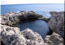
Lost in the ocean Matu Square of only 52 square kilometers is not in vain causes such close interest.
Strategic value
The Navy studies the possibility of creating ships on the smoke points. Far aviation has its own interest. Two expeditions on Matua are actually a full cycle of design and survey work, which must be fulfilled on the eve of the large-scale construction of a new naval base, more precisely, the point of logistical and technical support of the Pacific Fleet.
The first expedition examined Matua in May-July 2016. Experts conducted radiation and chemical intelligence, studied fortifications and other historical objects, fulfilled more than a thousand laboratory studies, made hundreds of measurements of the external environment, including the hydrography of bays and bays.
Matua is the island of the middle group of a large ridge of the Kuril Islands (in a straight line to Petropavlovsk-Kamchatsky - 670 kilometers, to Japanese Hokkaido - 740 kilometers). Administratively. During World War II was one of the largest Japanese naval databases. The root inhabitants of the island were Hunters - Aina, in 1875 they were replaced by Japanese military personnel. In 1945, Soviet border guards settled on the island, later - air defense units. In 2000, military facilities were molded on Matu, and the island became uninhabited for 15 years.
The island resembles a fortress in the middle of the ocean. Matuy reliably protected by impregnable rocks and high shores ,. Not bad Japanese dots, paved roads, three runways of the military airfield, as well as spacious underground structures of incomprehensible destination.
In the southwestern part of the Matua there is a convenient and relatively safe for the basing of the ships, covered by the winds with a small island of ax. It was here that the Japanese raid and berths were located. Since the 1930s, the island served as the Japanese bridgehead for further expansion in the direction of Kamchatka.
In August 1945, Soviet paratroopers found almost unarmed Japanese on Matu: 3,800 surrendered soldiers and officers turned out to be only 2000 rifles, and pilots, sailors and artillerymen simply disappeared (the garrison numbered 7.5 thousand military personnel). For comparison: Soviet troops seized on the island, Soviet troops seized more than 60 Japanese tanks. From interrogations of the commander of the Northern Group, General Tsumi Fusaki, it is known that the Matu's garrison did not obey him and managed directly from the bet on Hokkaido. The island had a special status and until this day keeps many secrets.
New fortress
Russia borders on the sea with 12 countries, and not all of them are friendly. Until recently, our Pacific neighbors - the United States practiced the military-political "deterrence" of Russia. And Japan claims to four Russian islands - ITUURUP, Kunashir, Shikotan and Habomai. And the strengthening of the Far Eastern frontier looks quite natural, where since 2015, a single coastal defense system is being created, necessary to control the pouring areas of the Kuril Islands and Bering Strait, covering the fleet deployment routes and increasing the combat stability of marine strategic nuclear forces. Steel Kuril Rud - Measure forced, but very efficient.
In Kurilla, the Okhotsk Sea is formed today almost completely cover the BRC (it is logical to assume the presence on the line of smoke and anti-aircraft missile systems C-400). New features of missile weapons allow you to create particularly protected areas of the sea (Anti-Access / Area-Denial), the most favorable for combat Patrol Patrol RPKSN - in four thousand miles from San Francisco and the positions of American strategic forces of ground-based in Wyoming, Montana and North Dakota .
Kuriles and Kamchatka should turn into an uncomplicated sea \u200b\u200bfortress Russia. And to realize this purpose, the small island of Matou is of great importance.
The second joint expedition of the Ministry of Defense and the Russian Geographical Society on the island of Matu was completed. Its participants - historians, archaeologists, environmentalists and hydrographs - told at the next meeting of the RGO about their amazing finds found on this small, but very mysterious island Kuril Ridge, Reports Corr. Ia sakhalinmedia.
The participants of the second joint expedition of the military and scientists at the Kuril Island of Mutua summed up their work. At the next meeting of the Sakhalin branch of the Russian Geographical Society, they made reports in which they told what new secrets is the island revealed for them and what discretions have given new questions.
Opened meeting chairman of the Department of RGO Sergey Ponomarev. He noted that cooperation with the Pacific Fleet gave new opportunities for studying the Kuril Islands.
"The expedition is most expensive - this is a transport delivery to the Kuril Islands. But the fact that Sergey Shoigu. He headed the Russian geographical society, allowed to organize these joint projects from the Ministry of Defense. The military is also sent to Matu with their research objectives. And take with you our scientists. We use this cooperation in their favor. Our studies concern history, archeology, ecology. Such multifunctionality helps a comprehensive study of the islands - both on land and in the sea, "said Ponomarev.

Meeting with members of the expedition to Matu. Photo: ia sakhalinmedia

Meeting with members of the expedition to Matu. Photo: ia sakhalinmedia

Meeting with members of the expedition to Matu. Photo: ia sakhalinmedia

Meeting with members of the expedition to Matu. Photo: ia sakhalinmedia

Meeting with members of the expedition to Matu. Photo: ia sakhalinmedia
He recalled that Matuie is very interesting from the point of view of local history island. He is in the middle of the Kuril ridge and was previously used by the Japanese as transshipment On the route from north to south, as well as a powerful naval base and airfield.
Historian-local history Igor Samarin During this expedition, last year's work continued. Its main task was to restore the scheme of Japanese long-term fire facilities on the island. Last year, such a card was drawn up, but, as it turned out, the island is still a lot of discoveries.
"This year quite by chance, our military colleagues discovered the exit of a ceramic pipe from the ground. Lose an improvised video camera into it - a smartphone with a flashlight, a room found there. At the depth of three meters it turned out to be a concrete structure, adjacent to the artillery freedation post. It turned out that there was a team office of fire control underground. From there, the teams to the tools were transferred from the help of electronics, "said Igor Samarin.
Also, one of the tasks of this year was the study of the Japanese team post on one of the heights of the island. A group of Samarina dutched this concrete structure and fell inside.
But the very interesting discovery Scientists did, studying small, not always obvious details. So, next to one of the soldier's barracks, we will find a lamp lamp. Igor Samarin explains: according to evidence of the Japanese military years of those years, the fleet sailors lived better infantry and they had the only one had electricity. So found Abazhur reinforced the confidence that the sailors lived in the barracks on the island.
"Many ordinary things were revelation. Here they found a beer bottle, the most ordinary, but on the bottom - the date of manufacture "18 S 8". For a knowledgeable person, this is simply - August 16 years, in the European Savenistee - 1941. Such bottles on the island found 25 pieces. They managed to determine the time when the bottles were supplied to the island. It turned out that the first supply of provisions began in 1938 and ended in 1943. And in 1944 the blockade began islands Matuy American submarines, "SAMARIN continued his report.
Scientists have not left without attention and Japanese kitchen piles near each earthquake. Among the waste were discovered bird bones. As it turned out, the Japanese were actively used in the food of local ax. They also ate mice - voles. Even a natural exchange was established - one mouse was worth two cigarettes. The skins of rodents were shipped to the metropolis for the manufacture of gloves from them.
In total, 86 items of the Japanese and Soviet period were brought from the island of historians - from children's booties and dishes before fuel barrels and handled stoves.
Also, scientists managed to reveal another riddle, which kept Matu Islands since the Second World War. For more than 70 years, the fate of the American submarine Herring, sinking two Japanese ship from Matua, was unknown and contradictory information was preserved about it. Hydrographers, headed by the captain of the Great Hydrographic Boat, Igor Tikhonov, fusked the entire Watercoat of Bay Double with the help of a multipath echo sounder. And the object, very similar to the submarine, was found in the area of \u200b\u200bCape Yurlov at a depth of 110 meters. What to do next with this discovery will determine the military.
In the framework of the expedition, researchers studied more ancient period of the history of the island. So, group archaeologist Olga Shubina I discovered on the island more than a hundred catlovanov from the ancient dwellings of the first inhabitants of the island. Most likely, they belonged to the ancient Ainam, live here 2.5 - 3 thousand years ago. Scientists spent excavations at the locations of the finds and identified the boundaries of archaeological monuments.
At the end of the meeting, the Chairman of the Sakhalin RGO Sergey Ponomarev said that scientists created a working group engaged in unification geographical names On the island of Matu.
"Many Matuities are still worn japanese names or "folk" Soviet. The group prepares a proposal for the official name of about three dozen bays, capes and heights, so that when making cards and schemes, we can use the same designations and understand each other, "Ponomarev said.
The other day on the tiny uninhabited island of Matu Kuril's ridge (about 52 square kilometers) began to work the second expedition of the Ministry of Defense of the Russian Federation. An impressive squad of warships and courts under the command arrived to the island from Vladivostok deputy Commander Tof Vice Admiral Andrei Ryabukhina. As part of the detachment of the BDK Admiral Nevelskoy, Kil-168 killeter and Sat-522 rescue tug. On their boards about hundreds of researchers and 30 units of engineering equipment to ensure various works.
Exactly a year ago, the first one expedition on the same "Admiral Nevelsky" has already visited Matu. And he also led her vice-admiral of Ryabukhin. Specialists conducted more than 1000 laboratory studies on physicochemical and biological indicators, more than 200 measurements of the external environment were made, radiation and chemical intelligence were carried out. Divers examined both tiny bays of this Sushi Kloch - Ain ( maximum depths up to 25 meters) and Yamato (depth of 9 meters). During the Second World War, it was through them that the seven-thousand Japanese garrison was supplied to the Mato, on which the largest and well-equipped military base of the imperial army was located. Most of its defensive structures were cut down in the surrounding rocks and served as a reliable shelter for personnel and combat seals.
But the main thing on the island was not numerous artillery dots and underground tunnels. The main importance was the largest military airfield at the time, which allowed the Japanese from these places to control the extensive part of the Pacific Ocean and the Sea of \u200b\u200bOcean, as well as most of the islands of the Kuril ridge. Three concerned and heated thermal underground sources of the runway (GDP) in length in 1200 meters each did an airfield almost all-weather. Nevertheless, in 1945, the Japanese 41rd separate mixed regiment was defended here (in three thousand soldiers and officers, the rest of the garrison was already evacuated by the rest of the garrison) surrendered to the Soviet paratroopers without a single shot.
Despite the fact that after World War II, the island remained almost delubful and the Soviet authorities, almost nothing was used, as it turned out, that airfield and today in good condition. In any case, Russian military helicopters since the summer of 2016 are already sitting at him. Is it capable of the island's airfield after small restoration work, also planes? And if yes, what types of? This, too, last year found out the expedition of Vice Admiral of Ryabukhin.
The goal of such an unprecedented activity of the Far Eastern seafarers is not a secret. For the first time about it in May 2016, at the military council of the Eastern Military District announced colonel-General Sergey Surovikin: The possibility of accommodation on the island of the new base of the Pacific Fleet on the island is studied. Moreover, on June 29, when the work of the first expedition was still in full swing, a certain unnamed source in the Ministry of Defense of the Russian Federation stated RIA Novosti that construction of base objects on Matu It will be started at a rabid pace - until the end of 2016. However, contrary to these plans while there is nothing there. Why?
It is known at least about one unexpected problem with which the TOO command faced: fresh water. When the Japanese garrison stood here, the water on Matu was clearly plenty. This is evidenced by huge concrete tanks, preserved in the rocks. As well as an extensive network of ceramic pipes, which stretches from them to defensive structures. While the pipes, understandable things, are empty. How to fill the cunning Japanese plumbing again, our engineers did not find out today. According to Vice Admiral of Ryabukhin, "We still do not understand exactly what and where I went and from where it flows out." In the meantime, this is a secret, it is impossible to start a construction site. Tankers and vessels-Aquarius of her needs in the lifeful moisture not satisfy.
But all this, apparently, temporary difficulties and new base On this island, our fleet will still ever receive. It seems to be important to try to understand why she is for us? And in general, what will it be for the base?
What can be said for sure today - for warships and auxiliary vessels there can be only temporary moorings. The reasons are not only that the bays of Ain and Yamato nature are too open and not enough protected from the ocean winds and storms. Although they are marked as possible places of anchor parking.
The main problem for creating a full-fledged ship-based location, obviously represents matu Vulcan Sarychev high 1446 meters high. His strong eruptions over the past century happened four times, in 1928, 1930, 1946, 1976, one eruption occurred in 2009. Then the two flux of hot lava crawled into the ocean, froze and increased the area of \u200b\u200bthe island immediately to one and a half square kilometers. No wonder in the language of those who had once in these parts of the people of Ainov Matuy - "Little Burning Pill".
But the volcano is not the only problem for Matu. This is a region of increased seismic activity. Regular mighty earthquakes cause destructive tsunami. Let's say that the most powerful in the history of modern smoked the Simushir earthquake, which happened on November 15, 2006, wrapped a gigantic wave on the island, which reached the height of 20 meters. What apparently is comparable to the consequences of the close underwater nuclear explosion. What would remain in this case from the berths and our ships on Matu?
Thus, the new item of ship basing Tof on Matu We will build hardly. Then in the name of what cheese bor? Restat a military airfield? Taking into account the three wonderful WFP built by the Japanese, their return to life, obviously, will not require great effort. But the length of each, as mentioned, 1200 meters, width - 80 meters. To plant even a helicopter regiment of this more than enough. For SU-27, Su-35 and MiG-29 fighters, too. But, let's say, for heavy bombers Tu-22M3 will be not enough, the strips will have to lengthen almost twice. But after all, it was in landing here the Russian long-distance aviation see the main meaning of the new military base on Mosti, most Russian military experts. Because in this case, within reach of our heavy bombers, the Pacific Coast of the United States will be. So, not only the "strategy" Tu-95ms and Tu-160 will be able to fly to patrolling the "state" front. The circle of potential threats to the Americans from Russia will be much wider.
On this account is full of optimism former commander-in-chief Air force RF General Army Peter Daenekin: "As for the airfield on Matu, then he is currently not enough to ensure heavy aircraft flights. But in the future everything will be done so that this airfield turns into an aviation base. "
The only question is whether this relief will allow terrain? After all, at least one lane for Tu-22M3 will have to lengthen more than twice as much as - up to 3-3.5 km. With the maximum length of the island at 11 kilometers and a 6.4 kilometer width, this may be a problem. Especially if you consider that a significant part of the territory is the volcano Sarychev. Surely and on the solution of this problem today, the expedition of Vice-Admiral of Ryabukhin is beating.
Meanwhile, even if the Russian long-range aviation will not be able to "plant" on Matuy, and it will be limited to fighters, a lot of meaning in a new island database will still be. Because the boundaries of our air cover opportunities of the atomic underwater rocket cruisers of strategic appointments, including new Boreev, in Vilyuchinsk (Kamchatka) will also be decently spread.
After all, today the task of a fighter cover of the Kamchatka is placed mainly on the 865th separate aircraft that flies on MiG-31 interceptors. The regiment is based on the aerodrome of Elizovo near Petropavlovsky-Kamchatsky. And Matua is about 700 kilometers south-west of the aircraft parking lots of the 865th separate shelf. Accordingly, in this direction to the center of the Pacific Ocean, the far boundary of the potential interception of the enemy air attack will be shifted. Winning in time and space for us in case of a sudden attack more than impressive.
There is nothing to say that the same thing on Matua will surely be done with the complexes of anti-religious winged rockets "Bastion", "Ball", as well as anti-aircraft missile systems S-400 "Triumph". Since last year, such a weapon is already deployed in Kamchatka, which immediately caused a completely understandable sharp response in the United States and Japan. There were concerned about the fact that in the Peninsula, Russia creates another "A2 / AD access limiting zone, as such areas are called in the Pentagon.
It was still believed that "A2 / AD zones" we have already been created in Kaliningrad, Crimea, under St. Petersburg, Murmansk, Yerevan and in Syrian Tartus. But all this in the North-West, Western and southwest directions. Now it was the turn of the Russian Far East. To the previous list of overseas strategists, it is necessary to plus and Kamchatka. However, if we manage to quickly turn into the fortress. And the island of Matuy, even the defense of the base of Russian atomic rocket cruisers will become deep-elapted. And to close to the peninsula will not work with impunity.
Reveal all the secrets of the Kuril Island Matu
One of the priority projects of the Russian geographic society today is an expedition to the island of Mutu. Despite several months of painstaking work on his study, many are still a lot of riddles. Fully tunnels and underground structures have not been studied. It is necessary to find out where the dishes of the Japanese imperial family and empty fuel barrels appeared on the matius, and a lot of things have to be.
The other day, TASS reported that several detachments of scientists from Vladivostok, Moscow, Kamchatka, from Sakhalin, will work as part of an expedition to Matu, which will be held from June to September.
Currently, the development of a detailed plan for surveys of the Kuril Islands was completed at the headquarters of the Pacific, the personnel and the necessary technique for survey work as part of the expedition to Matu Island in 2017. This year the composition of the expedition will significantly expand. On the island of Matuet, several detachments of hydrogeologists, volcanologists, hydrobiologists, landscapes, soils, submariners, search engines and archaeologists from Vladivostok, Moscow, Kamchatka and Sakhalin, said the head of the information support department of the press service of the Eastern Military District (VVO) on Pacific Fleet (Tof) Captain 2 rank Vladimir Matveyev.
According to him, now psychologists of TOOF are completing the professional psychological selection of future expeditionary participating servicemen who pass special tests and programs to establish the degree of stress resistance and the level of performance in extreme conditions, the psychological compatibility of future participants in the expedition and evaluate the moral and business qualities of military personnel.
Matua is the island of the middle group of a large ridge of the Kuril Islands. Length about 11 km, 6.4 km width. During World War II, it was located one of Japan's largest naval databases. In 1945, the island departed the USSR, and japanese base It was turned into Soviet. The island has a lot of fortification structures, mines, grotts, two runways that are heated thermal sourcestherefore can be used round year. In 2000, the base was conserved and Matu Island officially became uninhabited.
In 2016, the first joint research expedition of the Ministry of Defense of the Russian Federation and the Russian Geographical Society on Matua, participation in which was taken by the military personnel of the Eastern Military District and the Pacific Fleet. In total, more than 200 people were involved in the expedition. The Island Defense is the island as a possible point of basing the forces of the Pacific Fleet. Then the Matua discovered a branched network of tunnels, as well as the Japanese light fighter Mitsubishi Zero, released in 1942.
The second research expedition to Matu will take place from June to September 2017, it is planned to collect materials for the preparation of the atlas-determinant of the marine inhabitants of the Matua and neighboring islands. Also, researchers have to create a reconstruction of the activities of the Volcanana Peak Sarychev in Late Pleistocene, including historical eruptions, and mapping the island. In addition, it is planned to take into account the types of marine hydrobionts, compare the biots of adjacent waters to assess the state of biodiversity and to identify possible ways of migration and interpenetration of elements of flora and fauna in the northern part of the Pacific Ocean.
In September last year, the correspondent tvzvezda.ru was visited by Alexander Stepanov. We present an excerpt from his report "The Mystery of the Matuy Island: when japanese fortress will be the Russian base. "

Matu's island from a bird's height seems to be a small spot - 11 kilometers in length and six and a half in the width, two thirds of the island area occupies a valuable - Sarychev peak. The island is not at all adapted for life. Harsh climatic conditions: in summer, constant winds, rain. Sunny days once or two and turned around. Here even in June on the slope of the snow whiten snow. Snow cap yearly decorates and peak Sarychev. This volcano is glorified by what is one of the most active acting volcanoes of the region. Norov at the peak of Sarychev cool - you won't call him sleeping. Eruption, though short-term, but frequent and strong.
Despite all the natural cataclysms, the Japanese during the Second World War turned out the island into an impregnable fortress, where there were underground tunnels, and the airfield, and even the railway. The garrison on the island exceeded three thousand people. Generally, the Kuril Islands were used by the Japanese as a strategic barrier to exit from the Sea of \u200b\u200bOkhotsk in Pacific Ocean. Here we built a whole network of various military defensive fortifications.
To get to the island of air, you need a fair share of luck. The so-called windows are small lumets - open over the island very rarely, and people sometimes have to sit at the airfield for a few days to get into it that opened a short window. The nearest airfield from which you can go to Matu is located on the island of ITUURUP. It is about 500 kilometers. And if suddenly the weather over Matu is spoiled after the "turntable" almost flew to the island, then return to the base accounts for fuel residues. As helicopters say, "with adventures".
When adjusting to the island it is clear that it is exposed by coastal fortifications. Trenches, originating the very edge of the water. Dys and dzotes, swept in numerous hits of the island, look empty braces towards the sea. It is noticeable that the island really resembles a fortress, rising straight from the sea. In mid-June, about seven degrees of heat and penetrating the wind. It is necessary to warm in the winter: jackets, sweaters, shoes with high berets. Here, since May, the Expedition of the Ministry of Defense of the Russian Federation, the Russian Geographical Society, the Eastern Military District and the Pacific Fleet under the leadership of the Departure of Tof Vice Admiral Andrei Vladimirovich Ryabukhin.
Despite the fact that since September 1945, the island has switched to the USSR, no studies have been not spent on it. The current expedition is designed to solve the mysters of the very lowest island of Kuril Rud. And there are a lot of secrets here. There are three main tasks in front of the researchers: to study the military-historical component of the islands, to study the volcanic activity of Matu and understand how to develop military infrastructure on the island.
The RGU's scientific group is engaged on the island of routine, but very necessary work - makes up the map of the island: landscape, geological and soil. Selected samples of soils and plants. The second group is looking for artifacts that remained from the Japanese. So, in June, search engines raised the wing of the Japanese aircraft release of 1942 and brought him to the camp. Also found objects that can tell about life japanese soldiers: ammunition, dishes, clothes, household items. Members of the expedition even climbed the peak of Sarychev, where two flags were omnted - Russian Federation And the Andreev flag of the Navy.
The rise to the volcano is not just a waters of flags, the participants of the expedition tried to understand what parties there is an eruption with a train. From the height clearly seen where the island changed its structure, geography, where new beaches appeared. It was found out like Japanese barriers, including anti-extended outflows, blocked the path of the dirt that went towards the Japanese barracks. I am interested in one of the leaders of the expedition, the actual member of the RGO Andrei Ivanov, is it true Matua is an island-riddler, where the secrets of Imperial Japan are kept, or this is the suspicion of reporters.
"On the riddles, journalists love to ask questions," the scientist smiles. - Of course, it is still difficult to thoroughly study what remained from the Japanese, to understand where myths, and where reality. We managed to find out that the legends that there is underground city, built by them at the end of World War II, have a soil. We found quite a lot of entrances that lead under the ground, they all blown up or roasted. One such entry we excavated and found numerous underground moves, warehouses that were connected to the above-ground system of trenches and trenches with special strokes. This is not a legend, it is actually. "
At the same time, the main goal of the expedition is not to guess Japanese rebuses, but make a comprehensive assessment of the territory in order to understand how suitable it is for development, whether the villages and tsunami do not new infrastructure Islands. Also, the expedition is interested in how the Japanese garrison has solved life support, because, as it turned out, there are no sources of water on the island.

The head of the expedition, the Depcommer Tof Andrei Ryabukhin, told the Army Standard that the Japanese used exclusively with melt water, which formed by melting of snow on the volcano. Therefore, there are many old Japanese filters for water purification, which invented the chief of the 731th detachment in Manchuria Siro Issi (Japanese doctor who conducted inhuman experiments on people and developed bacteriological weapons). They assumed two types of cleaning, coarse and thin. Rough with the help of brushes removed from the water all the dirt and garbage. During thin through ceramic filters under pressure, water was drunk, then she was on trenches in special containers.
Part of the system was carried out in the area mining systemAnd part of the Japanese staged near the lakes, which were formed during the melting period. Near them pumping stations were installed. By the way, due to the fact that there were many rats on the island, which also used water, here they found strong antibiotics, which were literally risen underground hospitals. Tablets prevented a defeat of personnel. At the same time, the participants of the expedition argue that the production of bacteriological weapons on the island was not. After all, if something went wrong, then the Japanese garrisons in Kurili would have killed themselves.
The island was needed primarily as a huge base of storing and ensuring the safety of the extended communication line, which was held from the "big" Japan to the islands of Paramushir and Schisha, where large garrisons were. Only submarines and surface boats of Americans were represented by the safety of this route. Since the aviation of the Allies could not actively bomb the islands due to the flight range, the main focus was made to protect against the fleet. Therefore, on the island built a large airfield with two strips, where fighter aircraft and bombers were based.
Also on the island could be up to ten thousand people, so that, if necessary, strengthen the Japanese garrisons on northern Islands Schisha and Paramushir. I ask Ryabukhin: did the expedition manage to understand how the defense of the island was built?
"We found out the system of communications and fortification of the Japanese, understood how the defense structure of the Matuy was built - he says. - A feature of the island's structure is a large number of splashes - long gorges in which they concentrated their warehouses. A road system was developed on the island. It was a serpentine type and led there, where there were separate garrisons. Next to the garrison, a warehouse and barracks were equipped, as well as positions for defense - trenches, dots. While we can only assume how the delivery was carried out on the position of products and ammunition. It is already clear that on the mati were developed automobile transport and railway. "
Of course, the search engine itself has not yet found the railway, there are only her traces. One can only guess where it passed - these are tunnels, punched underground and, as artery crossing the island. The numerous finds are also evidenced by numerous finds: rusted trolleys, fragments of rails. In addition, brass or bronze pipelines for supplying fuel were laid around the island.
Search engines find the characteristic fittings and pumping parts, but the container where the fuel was stored until they were found. In addition, the expedition found out how the Japanese built their barracks. They were collapsible and consisted of a metal frame and wood. The tree also were trimmed with all the dots on the island.
The airfield of the Japanese is now in a rather deplorable state, he suffered a lot from aviation raids and natural cataclysms. Now there are several helicopter platforms. However, in the future, its restoration is possible. Of course, the main question: Do we need this block of land, absolutely unsuitable for normal life?
"Since last year, the Okhotsk Sea has become our inland sea, "Says Andrey Ryabukhin. - This is our sea. And here, so let's say a lot of open doors. And everyone wants to enter them. But with what intentions in these doors are included - good or not very, you will not immediately understand. To securely protect our territories, you need to make efforts, then not to regret that they did nothing. The loopholes are still there, and they must be eliminated, including the creation of Russian bases. So far it is planned that the Tof division will be located on the island, which will ensure the protection of state interests. "
At the same time, Vice Admiral believes that it makes no sense to restore the Japanese infrastructure on the island.
"Now, in modern conditions, deepen underground, build the city and railways expensive and inappropriate. - he continues. - Again, all underground communications that we open, very dilapidated. They crumble, dilapidated. The structure of the soil here is peculiar, including rocks very fragile. The fact that the Japanese was nailed here, for the time it was very relevant, now there is no longer. "
Conclusions about whether Matu is needed by armed forces, whether the base will appear there, will be made this year. And there is a high probability that our troops will still be located on Matua.
The second large-scale expedition of the Ministry of Defense and the Russian Geographical Society will go to the Kuril Island of Matua in 2017. On Wednesday, September 14, said the commander of the Pacific Fleet Admiral Sergey Avakianz at a meeting of the Media Club.
The Japanese began to master the island since the 1930s and gave him exclusively military significance. "The island served as a bridgehead for further expansion and capture of the Kamchatka Peninsula. Was created unique system Underground structures connected by a unified system of tunnels. Underground structures are a separate topic that requires a deep study, "said Admiral Sergey Avakianz.
According to him, underground facilities are divided into two types: fortification and structures of incomprehensible purpose are rectangular, square and round shape, length of up to 150 meters.
"It was originally the assumption that it was warehouse, but everything was taken out of them. And if it were storage facilities, then there would be no material trails. Moreover, it was found that the high-voltage cable is suitable for these premises, and the power supply system Allowed to give up to 3 thousand volts there. Naturally, it is an excessive stress for warehouses. But it is obvious that some work was carried out in these structures, "the head of the TASS expedition quotes.
Admiral also reported that the same high-voltage cable was found on the slope of the Sarychev volcano. "Vulcan alive, volcano is still breathing. Every 25 years occur powerful eruptions. Detected residues old roadleading to Zhero Volcano. The characteristic entrances to underground structures from the water surface are visible from the helicopter. We need serious deep-water studies of the northern and north-western part of the volcano, "said Avakianz.
He noted that during the expedition, dishes were discovered with symbols characteristic of the imperial family - stars, that is, the island attended the highest military-political leadership of Japan during the war, and garrison attached exceptional attention.
"If the Japanese garrisons fought fiercely, to the last soldier, the island of Matua capitulated last time, but capitulated without a fight. The garrison consisted of 7.5 thousand people and, not characteristic of the Japanese army, no resistance had no resistance." Told the commander. "We concluded that the garrison fulfilled his main task - removed all traces and all the facts that could bring to the disclosure of the true nature of the activity on this island," he continued.
According to Admiral, the expedition studied the volcanic activity of the island and discovered the remains of an ancient paleowalkan numbering several million years. "Thereby requires confirmation version that the peninsula of Kamchatka, the islands of the Kuril ridge and Japanese Islands They were a solid sushi strip, "said Avakianz.
The commander of the Pacific Fleet believes that further study requires the island of Toporova, which is supposedly associated with Matu underground tunnels. "With permission and at the direction of the President of the RGO in 2017, we hold a second expedition with the involvement of a wide range of specialists from the Academy of Sciences, RGO and Moscow state University. Requires further study of fauna, flora of this island, volcanic activity, water supply system, underground structures, including underwater. And, in addition, it is necessary to conduct archaeological studies, "concluded Admiral.
Command of the Eastern Military District The possibility of prospective basing forces of the Pacific Fleet on the island of Matu.