Even those citizens who have never got out of Russia have heard that abroad for travel on roads, as well as for the use of bridges and tunnels, you have to fork out. Now in our renewed Russia, smart businessmen have begun to collect money for travel on the roads. A striking example of this is the M4 highway ("Don"). Paid sites appeared on it in 1998. Now there are over 530 km of them on this road, and in the near future there will be almost two times more. How, apart from payment, are these sites different from alternative free ones? Are there any benefits to using them? How can drivers who do not want to lay out their hard-earned money can get to the destination without paying anything? Let's figure it out.
History reference
The route, which is now causing so much controversy, leads from Moscow to Novorossiysk through such big cities, like Krasnodar. Its length is 1543.7 km. Part of this route from Moscow to Rostov-on-Don was once called Route 5 and was built in the late sixties of the last century. During this period, the road was two-lane, with a width of only 7 meters. During the years of perestroika, the construction of its understudy began, on which no traffic lights were installed, that is, they tried to make it a high-speed one. In 1990, 18.4 km were commissioned, including two sections in the Domodedovo area. Until 2000, the development of the M4 highway actively continued, as a result of which the road became 500 km longer and stretched to Dzhugba, plus a piece of the Sukhum highway to Novorossiysk entered it, and 135 km of backup sections with a roadbed of up to 8 lanes appeared. They were built in the Moscow and Tula regions with funds from the state budget. At that time, no money was charged for traveling on the M4.
Paid sites
As a result of road construction manipulations, the M4 highway has significantly increased its capacity and has become more convenient. Paid sites began to appear on it since 1998. The first was only 20 km long and skirted the village of Khlevnoye. This part of the road was opened with pathos, as it became the first toll road in all of Russia. reconstruction with the construction of bypass sections was carried out with enviable activity. The result was two paid sites at once:
1. At 225.6-260 kilometers (35 km bypass of the city of Bogoroditsk). Now from the Moscow Ring Road to it, almost the entire section of the highway is paid (with the exception of a small piece 14 km long from the intersection of the M4 with the road to Uzlovaya to the intersection with the road to the village of Chornaya Gryaz).
2. At 287.8-321.3 kilometers (34 km detour of the town of Efremov).
Now, car drivers pay from 35 rubles here, depending on the time of day and class of car, and truck drivers - from 240 rubles.

Avtodor innovations
In 2010, the Avtodor company became the manager of the Don highway, which has a very positive attitude to the toll for drivers.
First of all, the company's specialists analyzed the condition of the road and started repairing it, simultaneously building new bypass tracks. As a result, it has become better, but also more M4. Paid sites have appeared on the following kilometers since 2010:
330.8-414.7 (bypassing the village of Yarkino and the city of Yelets).
416.9-464 (bypassing Zadonsk).
Bypassing the glorious city of Voronezh, several paid sections with a total length of 141 km were built. They begin at 492 km and end at 633 km, skirting Voronezh, Novaya Usman and Rogachevka. The free inserts are very short here, so that three payment points are set up almost one after the other.
paid sites (2016)
The Avtodor company is going to further shorten the sections of the road on the Don highway, which can be traveled for free. So, in 2016, two new sections with a total length of 190 km became paid. The first one starts at 21 km (just outside the Moscow Ring Road) and lasts 72 km. The second starts from this road bench and stretches for another 118 km. You have to pay for crossing the barrier twice, the first time - from 50 to 140 rubles, the second time - from 80 to 450 rubles. In total, by 2020 Avtodor intends to pay 892 km. Now their length is 531 km. Some drivers are interested in what Avtodor employees will do if they drive up to the toll collection point and say that money was accidentally forgotten at home. The answer will not please - such drivers will be forced to go back, but no one will raise the coveted barrier for them.

How many paid sections on the M4 highway ("Don")
2 in Moscow;
2 in Tula;
2 in Lipetsk;
3 in Voronezh.
In addition, in the Lipetsk region there are 5 toll exits to the highway.
In general, the fare from Moscow to Rostov-on-Don will now have to be paid for a passenger car from 510 rubles, and for trucks - from 2660 rubles one way, but it is quite possible that prices will change.

Road quality
Drivers, simultaneously with the question of how many paid sections on the M4 highway, are interested in the question of what they have to pay for. There are 8 lanes on the road from the Moscow Ring Road to the exit to the Vidnoye village. Further, to Saratov - 6 lanes, and after - 4 lanes. As the drivers testify, the quality of the roadway is good, but the speed on toll sections is allowed no more than 110 km / h. Unequipped toilets, gas stations, cafes are installed along the road. In addition, there are points where you can call a tow truck, a tanker or a repair crew. The disadvantage of toll roads (except for the price) is the queues at the payment points, and the transponder does not always help out, since there is no perfect system for its use yet.
The free road has mainly 4-5 lanes (3 or 2 in one direction, 2 in the other), in some sections there are only 2 of them (one to the south and one to the north). The quality of the track is satisfactory throughout the entire length, because the road services are also engaged in repair work here. Along the road, as well as on the paid M4, there are cafes, gas stations, and unequipped toilets. You can drive along this highway at a speed of 90 km / h. The inconvenience is created by large-sized trucks, which are abundant here. On average, the loss of time when bypassing the toll road is about half an hour.

How to get around from MKAD to Kashira
Recall that the M4 highway starts from the point where the Moscow Ring Road intersects with Lipetskaya Street. Paid sections are open from the 21st km, but so far Avtodor has blocked the road with barriers and installed the first payment point only at 62nd km. Therefore, from the Moscow Ring Road to the intersection with the A107 (this is the 51st km of the M4 highway), you can go for nothing. Also, the exits in the direction of Vidnoye (at the 22nd and 24th kilometers), exits in the direction of Domodedovo (this is at the 31st, then at the 34th and 46th kilometers) and the exit to A107 are not yet paid. Those who follow further from the Moscow Ring Road can travel for free along the Kashirskoye highway to the village of Sitne-Shchelkanovo. Further, at the fork, the road will go towards Stupino. Here, at the crossroads in front of the railway, you need to turn onto Pobedy Avenue, return along it to Kashirskoye highway and follow to the final destination. The disadvantage of this route is the rather heavy load on the Kashirskoye highway and, as a result, frequent traffic jams. This road is currently undergoing reconstruction, so if it is left free it would be a good option.

How to bypass the paid M4, following to Bogoroditsk and Efremov
There are several variants of detours to toll sections on the M4 highway. So, following to Bogoroditsk and further, you can use the route indicated above. This means that you need to go along the Kashirskoye highway to Stupino, turn there onto Pobedy Avenue, return without stopping in Kashira, follow to the fork in front of the village of Zendikovo, take it to the Voronezh highway, or continue along Kashirskoye to the P22 highway, which leads further and further from the M4 ... In the Venev area, this distance is approximately 30 km. To get to Bogoroditsk by this route, you will have to wander along country roads, the quality of which is far from satisfactory, and besides, "wind" extra kilometers.
Some drivers advise to go to Bogoroditsk and nearby settlements for free along the Simferopol highway (M2). The condition of the road surface here is excellent, the speed can be reached up to 90 km / h. After Tula, you need to turn onto the road leading to Bolokhovo and follow it to Black Gryaz. There will be an exit to the free section M4. The difference will be several kidometers. Those who need to go to Efremov can, following the same M2, without going past Tula, Shchekino and turn right at the crossroads in the village of Lukino. From there, an almost straight road will lead to Efremov.

How to bypass the M4 on the way to Voronezh
The shortest distance from the capital to Voronezh is 516 km. It is difficult to avoid every toll road on this long journey. The M4 highway from the Moscow Ring Road to Voronezh runs past Bogoroditsk and Efremov. Above, we described how you can get to these settlements for free. Despite some difference in mileage, many drivers choose Simferopol highway, which is quite pleasant to travel along. The number of lanes on this section fluctuates between 2 and 4, the condition of the road is good, there are many gas stations and cafes along the highway. Follow it further the village. Lukino is unreasonable, since in order to return to M4, you will have to make a solid detour. If you follow this route until the 321st km (the end of the Efremov bypass route, the difference in kilometers will be only about 7 km (about 307 km along the M2 and about 300 km along the M4). Then you can drive 9 km along the free section of the Don When you reach the exit to the toll road, do not turn onto it, but continue along the railway track, bypass Yarkino, cross the Sukhoi Kolodets stream, the railway track, go around Yelets on its outskirts, the Bystraya Sosna river, get closer again from the M4, drive through Zadonsk, Khlevnoe, the free section of the M4 and, without leaving the toll section, turn onto the road to Voronezh.The difference in kilometers along this route is very small, but the roadbed is much worse than on the toll road. The second inconvenience is traffic jams. in Zadonsk and the loss of time to travel through Khlevnoye and Voronezh.
How to bypass the M4 on the way to Rostov
A detour of toll sections on the M4 ("Don") highway ends in the Voronezh region, at the 633th kilometer. Further south, you can drive safely. A new section is currently being designed toll track bypassing the city of Pavlovsk, but so far it is not. To get on the free M4 from Voronezh, you need to pass 3 more paid sections. Two of them - through Novaya Usman 'and Rogachevka - can be passed without difficulty. As a result, the last 89 km remain. It will not work to bypass them with small losses. If you turn left after Rogachevka onto Р298, you will have to make a big detour. There are no convenient turns to the right. Therefore, the detour should be started from Voronezh. There are two options here - to the left along the road 193 or to the right in the direction of the Liski village. Both of these options are inconvenient due to the large excess mileage and poor-quality roads.
Traffic jams on the M4 Don are now displayed on an online map and show the situation on the road in real time. This feature becomes especially useful when you start summer vacations, when tens of thousands of tourists from Russia, Belarus and Ukraine rush by car towards the south and the Black Sea.
The Don highway will be in a state of local permanent road construction work for several more years, incl. I strongly recommend that you monitor the situation on the road, otherwise there is a high probability of spending from 5 to 20 hours for the whole trip on useless idle time in traffic jams, especially in Rostov region and Krasnodar Territory.
The data collected in the article is relevant for 2020, and as it becomes available new information the article will be supplemented and corrected.
Traffic jams on the M4 Don highway on the online map now
Online map of traffic jams on the Don highway allows you to estimate the scale of the traffic jam, see the current speed of traffic in specific location and understand exactly where to turn off the road in order to go around a large cluster of cars and not stand idle under the scorching sun, practically motionless, for several exhausting hours.
The maps are interactive and allow you to navigate the entire area, as well as zoom in and out using the mouse scroll or the "+" and "-" buttons on the left side.
Yandex traffic jams
A map with Yandex traffic jams in online mode shows the operational situation on the roads today and over the next week. The information is updated every 4 minutes and is automatically corrected on the diagram without requiring any action from you.
 Above the problem area in the upper right corner, the degree of its workload in points and the time of the last check are displayed.
If you click on the gear, a window with a slider will appear, with which you can predict the likelihood of an increase in traffic for the next hour. Under the slider there is an option to check the "Traffic events" checkbox - in this case, the map will immediately display all the places where repair work is taking place, an accident has occurred, or the passage is closed.
The "Statistics" tab accumulates information about traffic jams by days of the week for the past 2 months. By selecting the desired day and moving the slider to the desired time of day, we will see a highly likely simulated traffic situation that should be expected in the near future.
By clicking in the upper left corner on the button in the form of a black arrow, you will move to your current location.
Traffic jam avoidance scheme
Below we will consider the most problematic sections of the M4 highway, where in holiday season the formation of lingering traffic jams is observed. In addition to traffic congestion routes, added online maps with the current situation on the roads.
The village of Losevo is located on M4 "Don" in the Pavlovsky district of the Voronezh region. Below is a detailed description of how to get around the traffic jam in Losevo from and to Moscow.
Method 1 - any direction
Residents of Voronezh and the region have studied the bypass routes best of all and, in their opinion and experience, today the undisputed leader is the Sredny Ikorets - Liski - urban-type settlement (not to be confused with the neighboring village) Kamenka - Pavlovsk. The bypass road is good, it takes 1 hour and adds an extra 90 km.
If you go in the direction of Moscow, then, before reaching Verkhny Mamon, you can leave the toll road a little earlier and adhere to the following settlements: Derezovka - Novaya Kalitva - Rossosh - Liski.
Vladimirovka - Gran - Pokrovka - Losevo - frankly not the most best routepassing through villages with a rather poor asphalt surface and through fields with forests on a rolled dirt road (10-12 km) with deep puddles. But, despite this, vacationers travel here and do it often. In dry weather, Astra, Mazda 5 and 2110-level puzoterkas pass without problems. Only 50 km, hook 25 km, time - 1 hour.

M4 - Berezki - Poddubny - Losevo - the road is generally tolerant, without gravel roads and marches across the field. In Poddubny, the asphalt is good, and outside, as usual in the village.

Video with alternative routes
There is a playlist under the video player where you can choose the appropriate way to get around.
Bypass traffic jam in the Kamensk-Shakhtinsky (Kalinovka) area
The city of Kamensk-Shakhtinsky and the Kalinovka farm in the Rostov region in the summer become another obstacle for tourists who want to get to warmer climes or return to your favorite job.
But it doesn’t matter, I’ll tell you how to painlessly bypass the traffic jam in the Kamensk-Shakhtinsk area.
Option 1 - to the South
In Kamensk-Shakhtinsk itself we turn right in front of the junction from the M4 highway to st. Heroes of the Pioneers, after about 3 km we run into another interchange, where you need to call on it from back side, to go to the left through the railway track, immediately to the right and go around the park along the street. Likhovskoy, on the circle we keep the main (straight) on the street. Profile, we pass the next circle, to the right onto the A-250 highway, soon it will bend sharply by ~ 45 degrees, leading to the street. Marine.
After about 5 km, do not miss the turn to the Volchinsky farm, then Svetly, past the Uglerodovsky urban-type settlement through the railway track, we drive through the Likhovskoy microdistrict on the street. Pushkin, at the end to the right and, slightly wagging, this road will take you back to the Don highway after ~ 8.5 km. The total mileage is 55 km, the time is 1 hour.
In the village of Molodezhny we turn off the M4 and keep along the railway tracks, pass the railway station Bozhkovka, after 1 km to the left, past the village of Topolevy, through the village of Bozhkovka and x. Volodarsky. The hook is 40 km, it takes ~ 40-50 minutes, the coverage is ok, with a few exceptions, but that's okay.
Avoiding traffic jams in Rostov-on-Don
In the Rostov region, toll sections of the M4 Don highway will be built for a long time, so there is no full-fledged ring road yet, and in the summer the approach to Rostov is catastrophically overloaded with transit vehicles of tourists. In order not to waste precious vacation time breathing the exhaust gases of hundreds of smoking cars, use the suggested recommendations.
Traffic jams in Rostov now on Yandex map
We leave the M4 to Novocherkassk-Bolshoi Log-Aksai.

Direction to Moscow - we leave the Don highway near Vodyanoy Balka.

Moving towards the capital, if you passed the stationary traffic police post and entered the Tsukerov Balka, you will have to move onto a well-rolled field road. Local "businessmen" offer escort to uninformed travelers for 500 rubles.

If the final (intermediate) point of travel is planned in the Anapa area, i.e. it can be the Kerch crossing and Gelendzhik, then the traffic jams of Rostov-on-Don can be bypassed from the other side of the city and keep the way to the sea along the Azov highway.
It will look like this: on the M-4 "Don", after Krasniy Kolos, before reaching the village of Rassvet, we turn right to Krasny Crimea, through the Leninavan farm past Koisug we get to the Novoaleksandrovka farm. We continue to drive past the dacha non-profit partnership (DNT) Michurinets-3, through Peshkovo to the villages of Starominskaya and Staroderevyankovskaya (Kanevskaya). The further path to the South is described below under the "Scheme 2" spoiler.

How to get around the traffic jam in Timashevsk?
Through Timashevsk, a dense stream of vacationers' cars travels towards the Kerch ferry, but the city greets guests with serious congestion due to the railway tracks passing there.
Today's state of affairs on the roads
In order not to get into a traffic collapse on the road to the sea, use the proposed roundabout scheme.
Moving from Bryukhovetskaya on the roundabout in front of Timashevsky, ignore the turn to the right and continue straight (to Krasnodar). We are looking for a turn to the city on the street. 50 years of October, we drive to st. Shevchenko, where we again leave to the right until the intersection with st. Brothers Stepanovs, at this intersection we turn left towards st. Profile. We cross the railway crossing and go left to the street. Victory or Voroshilov.

The described option, although it saves you from certain troubles, is still not without some disadvantages due to driving around the city.
This route assumes to completely exclude Timashevsk and go past it: the Don highway - the village of Kanevskaya - Bryukhovetskaya - Novodzherelievskaya - Grechanaya Balka - Slavyansk in the Kuban.
We leave Kanevskaya behind and in Pereyaslavskaya we leave for Bryukhovetskaya, through the Pody farm we reach the village of Novodzherelievskaya and through Rogovskaya we get to Grechanaya Balka. Then there will be the villages of Novonikolaevskaya, after it Starodzherelievskaya, Poltava and at the end of Slavyansk-on-Kuban. I would like to draw your attention to the fact that it is forbidden for transit vehicles to go through it, so we use the ring road. The hook turns out to be only 15 km, but no unnecessary unplanned long stops.

Video bypassing Timashevsk according to scheme 2
Dzhubga - traffic jams and their detour
Krasnodar Krai is famous for its epic cork during the holiday season Hot key - Defanovka - Dzhubga. But on this section of the M4 Don highway, tourists go to rest in Gelendzhik, Tuapse, Sochi, Adler and Abkhazia. In order not to waste your nerves and irreplaceable hours of the long-awaited vacation, I suggest that you familiarize yourself with an alternative route to the sea, passing through the Shahumyan pass.
Current online congestion level
I'll clarify right away that for the most part there is no asphalt surface, and you have to drive on a normal gravel road with an average speed of 20-40 km / h, everything about everything takes 25-30 minutes. In rainy weather with low ground clearance, it is better not to meddle on the pass, and in dry weather, lowered cars with a ground clearance of 10 cm pass quietly.
I describe the direction towards the sea: before reaching Goryachiy Klyuch, we leave the M4 highway to the villages of Saratovskaya and Kubanskaya, pass Apsheronsk and Khadyzhensk, fly over Shaumyan and find ourselves in Tuapse.

How to get along the M4 Don without wasting time?
To minimize the likelihood of getting stuck in traffic jams for a long time, try to follow simple tips based on the experiences of tourists who are personally "lucky" to survive all this torment.
- The car must have a navigator with up-to-date maps and a speedcam - this way you will avoid confusion when driving over rough terrain, and you will be warned in advance about approaching stationary traffic police posts, video cameras and current speed limits.
- Mobile Internet will allow you to track upcoming problem areas online and build bypass maneuvers in advance.
- Carry out a thorough pre-train preparation of the car: check the level of freon and top up if necessary; make sure that the radiator does not leak, otherwise you will very soon be left without an air conditioner; change the antifreeze or make sure of its quality, otherwise there is a chance to get up at the wrong time with an open smoking hood on the very heat; pads and brake discs must repeatedly withstand the serpentine test; before the trip, change the oil and all filters in a circle; do not take risks with bald tires; remember if it's time to change the alternator belt, timing belt and pump; stock up on a few spare low and high beam bulbs; make it a rule to refuel when the tank is empty by 40-50% at empty branded gas stations or purchase a canister, because there are terrible queues at many gas stations; install an application on your smartphone with traffic rules of the Russian Federation and valid fines for constructive communication with traffic cops; buy caffeine pills at the pharmacy to increase wakefulness by 2 hours and not fall asleep while driving; take a look at the expiration date of the fire extinguisher and the first aid kit; have plenty of water and enough food in the cabin.
- will reduce their cost and allow faster passage of checkpoints.
- Plan ahead to be in Losevo at night, roughly between 10pm and 7am, or late afternoon if it is a weekday (Monday-Thursday). This recommendation is also relevant for Goryachiy Klyuch - Dzhubga.
- Settle up for the night in well-lit, safe crowded places or motels - avoid spending the night in a dark deserted field or on the side of the road where there is a busy traffic flow within a meter.
- Initially, remember that you will not be able to avoid all traffic jams, so throw in a few hours for the planned trip time and accept the upcoming inconveniences as something inevitable, but not fatal.
- Help other travelers with your tips 😇 and leave them below in the comments.
(function (w, d, n, s, t) (w [n] \u003d w [n] ||; w [n] .push (function () (Ya.Context.AdvManager.render ((blockId: "RA -142249-1 ", renderTo:" yandex_rtb_R-A-142249-1 ", async: true));)); t \u003d d.getElementsByTagName (" script "); s \u003d d.createElement (" script "); s .type \u003d "text / javascript"; s.src \u003d "//an.yandex.ru/system/context.js"; s.async \u003d true; t.parentNode.insertBefore (s, t);)) (this , this.document, "yandexContextAsyncCallbacks");
Usually people are in a hurry along the tracks and don't really stop. Unless just refuel the car, have a snack, buy water or something else vital ...
What if you are in no hurry? Or hurry, but not too much? ..

M4-Don highway in Rostov region, 781st kilometer
So, let's imagine that you are driving along the M4-Don highway ... well, let's say, from Moscow to Novorossiysk. And you have some time. And now you enter the Rostov region. And you want not just to drive it from end to end (by the way, several hundred kilometers, if absolutely 342 kilometers), but also to see something interesting ...

M4-Don highway in the Rostov region, 837th kilometer
The route leads to the Rostov region from the Voronezh region (the last relatively large settlement among the neighbors is the village of Verkhniy Mamon).

Verkhniy Mamon is also the Voronezh region, also the Dyadin farm - and we are in the Rostov region
In the Rostov region, the Don highway follows the following route: Millerovo (leaving this city to the west of the highway), Kamensk-Shakhtinsky (passing through it along the edge), Krasny Sulin (leaving it to the west), Shakhty (leaving them to the east), through Aksai, past Rostov -on-Don along the bypass road, across the bridge over the Don River, and goes south, past Bataysk and the village of Samara (leaving them to the west) to the Krasnodar Territory.

M4-Don highway, legend in the Wikipedia version. We have more details 🙂
Interesting fact: Do you know that in the Rostov region, the city of Rostov-on-Don, the border between Europe and Asia runs along the Don River? Rostov-on-Don is located in Europe. And Bataysk is in Asia. Thus, you can travel from Europe to Asia along the Don federal highway.
The magic of numbers and distances
Steppes, steppes, steppes ... Somewhere on the Internet I came across the opinion that the most boring part of the M4-Don highway is the Rostov region. Do not believe such statements!
Yes, our landscapes are somewhat monotonous (although after traveling through Kalmykia, I'm not so sure of this anymore). Of course, you will not see any mountains, seas, or rocks from the road. But you will see waste heaps, hills, rivers, small forest belts, in the summer - cheerful fields of sunflowers ...

Sunflower fields along the track
And if you pay a little attention to the M4-Don highway in the Rostov region, it will become much more interesting ...
When entering our area from the north side, I always think about the magic of numbers. The Rostov region begins at the 777th kilometer from Moscow.
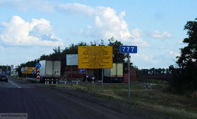
777th kilometer - the Rostov region begins here
Three lucky numbers (by the way, there is a Lukoil gas station on the 777th km of the highway).

And if you also remember that the license plate of the region is 61 (in numerology it will be 6 + 1), then in the end the same seven. This explains a lot, doesn't it? The track in the Rostov region is the happiest! I'm kidding, of course. But, as you know, in every joke ...

Sign on the border of the Rostov region
The M4-Don highway, passing through the Rostov region, crosses 8 districts: Chertkovsky, Millerovsky, Tarasovsky, Kamensky, Krasnosulinsky, Oktyabrsky, Aksaysky and Azovsky. And in almost each of them, not far from the track, and sometimes on it itself, there is something interesting.
Here we go? And you yourself decide where to turn off, where to stop, and where not ...
Chertkovsky district
And we will start in order, as we go, from the north of the region. The Don highway begins in the Rostov region in the Chertkovsky district (of course, if you go from the direction of Moscow).

And right after the Voronezh region we cross the border line between the regions and find ourselves in the Chertkovsky region.

Chertkovsky district
No wonder he, apparently, is so called: there is an invisible line between the lands. In the north of the district - with the Voronezh region, in the west - with Ukraine. But seriously, the district is named after the military chieftain Mikhail Ivanovich Chertkov.

If, immediately after entering the Rostov Region, you leave the road to the left (just after the 778th kilometer, the photo of which is above), towards the Kazanskaya village (65 kilometers from here), then there is a lot of interesting things.

Interchange on Kazanskaya
For example, the underground monastery of the village of Migulinskaya (Verkhnedonskaya district). But this is too far for those who are just driving along the highway and do not intend to spend several days in our region.
779th kilometer - resting place near the Nagibin farm in Chertkovsky district. Here you can gain strength before exploring the large and interesting Rostov region.
801st kilometer. Here: traffic police, turn to Chertkovo, cafe, roadside motel.

Interchange at Chertkovo
District center - village Chertkovo... Turn right after the 801st kilometer. And then another 30 kilometers to the village itself.
What is this village remarkable for? It has a street of Friendship of Nations, along which the border between Russia and Ukraine runs. Yes, yes, the houses on one side of the street are on Russian territory, and on the other, they are already Ukrainian. The street with the same name, but already - the village of Melovoe, Luhansk region. Can you imagine how many times a day you can go abroad?
But if you are not interested in jokes of this kind, then in the Chertkovsky district there are other significant, historical sights.

M4-Don highway in Chertkovsky district
For example, the square from "Quiet Don" in the village of Mankovo-Kalitvenskoye. It was on this square that Grigory Melekhov arrived for military training. And to this day, the Maidan in front of the church has been preserved here, where the Cossack circle gathered.
Also in this village, on Sovetskaya Street, you can see the grave of the writer Yevgeny Petrov, co-author of Ilya Ilf on "The Twelve Chairs" and "The Golden Calf".
If you have time, keep in mind that there are also natural attractions. The most important of them is the Zhuravsky reserve, which spreads over 12 thousand hectares.
Millerovsky district and Tarasovsky district
Here is the Millerovsky district. It is located in the northwest of the region, and borders Ukraine for 70 kilometers.

At the 854th kilometer - Bashneft filling station.
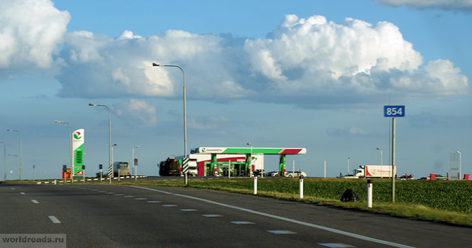
Refueling "Bashneft" at the 854th kilometer
The entire section of the route in the Rostov region has been landscaped. The bus stops are illuminated at night with solar-powered lanterns. There are toilets near the stops.

At the 855th kilometer there is a junction to the village of Veshenskaya. There - state Museum-Reserve of M.A.Sholokhov... From the junction to Veshenskaya - 142 kilometers, to the Sholokhov Museum - 144 kilometers. The museum is located in the Sholokhovsky district, in the village of Veshenskaya at the address: Sholokhov Street, 103. But the Sholokhov Museum-Reserve is a separate topic.

Interchange on Veshenskaya
860th kilometer - junction at Millerovo... It is only 4 kilometers from the highway. The city of Millerovo itself is small and industrial. It is notable for the fact that it is the most northern city Rostov region, and the whole South federal district... Stands on the Glubokaya River. It bears the name of the Russian German Ivan Miller. In our case, Millerovo is also notable for the fact that it is located exactly in the middle of the path along the M4 highway (if you take it all, and not just a segment in the Rostov region).
In addition to the places associated with the name of the great writer Sholokhov, there are other attractions in the Millerovsky district. For example, Voloshinskaya mountain - a favorite training place for local hang gliders. It is located near the village of Voloshino.
There is still Fominsky reserve, on the territory of which there are 176 kurgans (23 of them are archeological monuments).
After the 878th kilometer, there is the Tarasovsky district.

There used to be huge traffic jams in front of Tarasovka, and here you could get stuck for a long time. Now they have made a bypass road, and this section of the road has become comfortable for drivers.

To Tarasovsky 39 kilometers
It seems that about the Tarasovsky district is all that I can tell you. To be honest, I don't know much about the regions in the north of the region. But for sure, there are no attractions right next to the highway.

To Tarasovsky 11 kilometers

Another 202 kilometers to Rostov-on-Don
Well, how do you like the beginning of the M4-Don highway in the Rostov region?
And a big request to everyone who knows these regions well - write your additions in the comments! Maybe I forgot something or overlooked on the way ...
All materials from the Roads of the World website are copyrighted. Please do not take articles and photographs without the permission of the author and the site administration.
© Galina Shefer, Roads of the World website, 2014. Copying of text and photos is prohibited. All rights reserved.
——————-
Similar entries:
(function (w, d, n, s, t) (w [n] \u003d w [n] ||; w [n] .push (function () (Ya.Context.AdvManager.render ((blockId: "RA -142249-2 ", renderTo:" yandex_rtb_R-A-142249-2 ", async: true));)); t \u003d d.getElementsByTagName (" script "); s \u003d d.createElement (" script "); s .type \u003d "text / javascript"; s.src \u003d "//an.yandex.ru/system/context.js"; s.async \u003d true; t.parentNode.insertBefore (s, t);)) (this , this.document, "yandexContextAsyncCallbacks");Every time, returning from travels to the sea, I write about what the road was, in what condition is the route on this moment time that has changed since the last time. I pay attention to gas stations, and places of rest and snacks, and hotels for overnight stay. I will not change this tradition now. Before proceeding to the story about the rest, I will show how we drove along the M4 "Don" highway to the sea, I will briefly talk about the most important thing.
Our trip south by car took place in June 2016. All the way I collected receipts from gas stations, toll points at toll stations, cafes, and more. How much it costs, payment time ... Such things are quickly forgotten. You will not have time to reach your destination, you have already forgotten everything. After all, the main thing in a trip is not numbers, but emotions.
In this article I will show you highway M4,
will do accents on paid sites (quantity, fare, location), I'll tell you where we refueled, where we ate, where we spent the night. I am constantly asked about this. So it is relevant.
I will conclude the article with a story about hotels on the Don highway, where you can stay overnight on the way to the south. It is based on the statistics of the most popular hotels among travelers, which I have as a booking partner.
Here's a plan. So let's go!
First, I'll show our path in photos. So I will introduce you to the track and its condition. You will know what to expect. :)

Moscow. MKAD

M4 highway appears on the signs

Rebuild and turn

M4 is not a road, but a runway :)


IN Tula region M4 is somewhat florid ...

Tula gingerbreads are sold along the road in the Tula region

Toll roads are good because they have emergency commissioners, assistants to motorists.

On paid sites there are electronic boards for announcements (including with the phone of the emergency commissioner, information about the speed and air temperature).


M4 highway in Lipetsk region

Stele "Lipetsk region"

We enter the Voronezh region

The weather turned bad before our eyes, it started to rain ...

and then it sprang up like a bucket ...

Toll collection point near Voronezh

We go round Voronezh

The M4 has not yet been completed. Some areas are being repaired ...

Another area to be repaired


Chalk mountains of the Voronezh region


820th kilometer of the Don highway


One of the hotels on the M4 highway - "Bike" in Kamensk-Shakhtinsky

Hotel "Pharaoh" at 937 km.

We pass the hotel "Meridian-South" in Krasniy Kolos (1040 km. M4)

Motel "Eurasia" in Aksai

Rostov-on-Don

Entry to Krasnodar Territory


The hospitable Kuban greeted us with rains and dullness

Chapel, monument, museum in honor of the Kushchevskaya attack (events of August 2, 1942)


At this turn, we turned off the Don highway and drove to Anapa.
Toll road sections on the M4 highway
I heard on TV that in August 2016, the eighth toll section of the M4 highway opened. Judging by our experience, there were already nine of them as of June 2016. In my "piggy bank" 7 checks + 1 check we forgot to take + 1 section we drove on a free road.
Yes, Kostya decided to be an explorer and find out what these free bypass roads are. Alternative, as they are called. I was categorically against - there are a thousand kilometers ahead, I have no time for experiments. As a result, we toured only the first paid section from Moscow. The detour is quite good. Although two-strip, but the canvas is normal.

The road quality on this bypass is normal.
The next time we drove off the road at the sign "free travel", we immediately returned back - the normal road ended ... Kostya did not want to experiment anymore, fortunately ...

Exit to the free road around Efremov
Paid plots М4
Moscow region.
1 / The first paid section that we have traveled: 21 - 93 km. Price: 50 rubles. at night (on way back)

Signpost for a free detour of the toll section
2/93 - 211 km. Launched later than we drove. We passed it without payment.

Points of collection before their opening
Tula region.
4 / M4 "Don" bypassing the town of Bogoroditsk. 225.6 - 260 km. The toll collection point is 228 km. passed at 8.56. Fare: 60 rubles.

5 / M4 bypass of Efremov. 287.8 - 323.3 km. Collection point at 322 km. passed at 10.29. Price: 60 rubles.


Lipetsk region.
6 / M4 bypass of the town of Yelets. 330.8 - 414.7 km. The collection point is 339 km. passed at 10.43. Price: 120 rubles.


7 / M4 bypassing the city of Zadonsk and with. Khlevnoe. 414 - 464 km. We passed the toll collection point for 416 km at 11.40. Price: 80 rubles.


Voronezh region.
8 / M4 bypass of Voronezh. 492.7 - 517 km. Toll collection point at 515 km. passed at 12.54. Price: 35 rubles.


9 / M4 PVP-545 km. 544 - 588.7 km. 545 km passed at 13:18. Price: 70 rubles.


10 / M4 PVP-620 km. 588.7 - 633 km. 620 km. passed at 14.12. Price: 60 rubles.


Total: at the moment there are 10 paid sections on the M4. We passed at eight. We paid about 550 rubles.
Gas station on M4
Back in Moscow m we refueled at a Shell gas station (41 liters for RUB 1,680). The gasoline was bad. The car was constantly deaf. There was one more time during the whole 3.5-week trip when we refueled in the Shell, and the problem was the same. Here's your favorite gas station ...
The rest of the time, on the way south, we refueled at Lukoil, and everything was fine:
- Gas station "Lukoil" at 720 km. in the Voronezh region 38 liters. - 1,437 rubles.
- Gas station "Lukoil" in st. Kushchevskaya 28 y. - 1 119 rubles.

New complex "Lukoil" in Kushchevskaya (1145 km, on the right) consists of a hotel, shopping center, restaurant, service station and gas station.
In total, on the way to the south, we refueled for 4,240 rubles. (rounding up). This gasoline was enough for us to get from Moscow to Anapa, drive there for a week and then get to Gelendzhik.
In Gelendzhik, they refueled again at Lukoil (43 liters for 1,705 rubles). And the next time was already in Sochi a week later ...
M4 toilets
Brick toilets of the "hole in the floor" type are often found along the highway - and free-standing, most often near stops public transport and in large recreational areas.

These toilets are mostly dirty. In order not to drag all this into the car later, I recommend choosing gas stations for sanitary stops. In any case, the toilets there are much cleaner, and you can wash your hands and drink coffee in a cafe.
Coming from Moscow, stop somewhere at a large gas station in the Moscow region (Shell, Gazpromneft, etc.). In the Tula region with gas stations where there are toilets, a huge problem, in Lipetsk, in general, too. Skip the Moscow region, then wait for the Voronezh region. By the way, the same goes for way back... To Tula and Lipetsk region don't count too much! To the woods too. This is not the right track.
Where to eat on the M4
We have a tradition - we always stop at a new generation Lukoil gas station in the Voronezh region, 720 km away. (there are gas stations on both sides of the track!). These are not just gas stations - this is modern complexes, where there is a cafe, toilets, a store, children's playgrounds (both indoors and outdoors), etc.

Hotels on the M4 highway
There are plenty of hotels on the M4 highway. These are simple motels for truckers, and more or less decent hotels. What advice can you give to those who haven't bothered about where to spend the night on the way to the sea? Better to avoid cheap motels right off the road. Choose hotels that are at least slightly remote from the highway and have a closed area. An example of such a remote hotel is "Rose of the Winds" (practically on the border of the Voronezh and Rostov regions).

If you are not an extreme by nature, book your hotel room in advance. Not sure when you will arrive at the hotel? It doesn't matter at all. You know the day. Check-in - at any time of the day.

Analyzed the statistics of bookings by city and hotel. Most often, the following cities and towns are chosen to stop overnight on the way south (M4 highway):
- Voronezh,
- Millerovo,
- Mines,
- Red ear,
- Kovalevka,
- Aksai,
- Rostov-on-Don,
- Mayakovsky,
- Kushchevskaya.
The choice depends on where people started from. It is more convenient for Muscovites to stay in Rostov and in the vicinity of it. Petersburgers - in Voronezh. Tulyaks - in the Krasnodar Territory. There are, of course, personal preferences, but everything is individual here.
Now the most popular hotels in May, June and July 2016. The list is very different from what I would recommend to you. I suspect that the majority of hotels are popular due to economic preferences (the same "Alpha" in Rostov) and less - due to comfort and coziness (for example, the Rodina hotel in Mayakovsky). What you choose - decide for yourself.
We always stay overnight. We do not take risks, we do not strain. Riding without rest is not about us. It's not about us going into the unknown, looking for where to stay for the night along the way. We stay overnight in pre-booked hotels that provide a relaxing stay and good food.
We never force ourselves. We get up at a comfortable time and drive at a calm speed. And we get pleasure from the process of driving. Yes, the path is not short. About 1,600 kilometers. But on a highway like the M4, it's not scary at all. Excellent track, God forbid, that there were more of these!
Updated 07.06. Views 1590 Comments 56
The entire path of 1500 km took us 3 days and on the way we stopped in for a day, it was almost on the way. In principle, this path from Moscow to Gelendzhik / Sochi / Anapa can be covered in a day (18-25 hours), but I am not a fan of such long journeys in one sitting, especially at night and when there is no one to replace you, the risk is unjustified. Driving for 500 km is the most, the driver does not lose concentration.
If you want to quickly and without stopping, then it's better by plane (via /), indeed, faster and at the same time much safer. Moreover, when it comes to a vacation of a couple of weeks.
Route Moscow-Gelendzhik / Sochi
If you go with two nights, then the most optimal stops will be in the Voronezh region and in Rostov-on-Don. Thus, the path will be divided into 3 sections of 500 km. On the one hand, these cities are full of housing on the same (follow the link for my detailed post about the service and the $ 32 bonus), on the other hand, entering and leaving the city takes time, so to save time it would be better to stop at inside the city, and in roadside hotels on the highway.
If you are not in a hurry, then a normal one-room apartment on the outskirts can be easily rented for 1500-2000 rubles (I recommend an apartment), and a comparable hotel will cost twice as much.
Alternatively, plan a route with only one overnight stay, for example, leave Moscow in the afternoon, get to Voronezh in the evening, spend the night in front of him at the hotel, and from early morning move on straight to the sea. Or to plan a single overnight stay in front of Rostov, where the highway passes through several settlements where there are motels and private accommodation.
Picky travelers can generally spend the night in a tent in forest belts, and "truckers" drive for 18-25 hours without rest and overnight. I personally do not want to take risks, so I try not to make long runs, as I get tired and lose concentration, especially at night. Yes, I could drive those 1,500 km in one sitting, but I don't see the point.

If the ultimate goal is Sochi, then driving through the Tuapse-Sochi section is not pleasant without a preliminary break, there are serpentines, traffic jams, and this segment can take a decent amount of time, 2-3 times more than usual (when compared with flat sections). Ideally, drive through it early or early in the morning, while there are still few cars, or at night. My average speed turned out to be 45 km / h, there were sections with one-way traffic (repairs), plus, although trucks are sometimes allowed to pass on uphills, in general, it was still impossible to go fast. Only closer to Sochi and after that normal speed. In settlements (and they are there) there is often a limit of 40 km / h, on the highway 70 km / h.
In Gelendzhik, I usually go through Dzhubga, I like it more, a calm road, but there is an option to go through Novorossiysk. It is better to go to Anapa, leaving the M4 highway after 100 kilometers after Rostov to the village of Kanevskaya, and then drive through Timashevsk, Slavyansk-on-Kuban, adhering to the Temryuk direction, but the road there is so-so. After Slavyansk it will be necessary to go to Anapa.
Travel time
As I wrote above, it all depends on how much you want to spend the night on the road and whether you want to at all. We all went to the sea together, so we spent 2 nights, in the end the road took 3 daylight hours at a calm pace.
I rode back alone (the family flew away by plane) from Adler to Moscow. I got there in 26 hours, of which about 5 I slept in the car near the gas station. That is, the road itself took 21 hours. Quite quickly, I count. Somewhere for 20-25 hours and it is worth counting, without taking into account the long stops for sleep.
Route M4
Stripes and coverage
I have already traveled many times on the road to the Black Sea. The track is slowly but changing for the better.
- First of all, we almost made two lanes in each direction from Moscow to Goryachiy Klyuch. Almost, because, unfortunately, there are still sections with one lane. For example, in the Voronezh region near the villages of Losevo - Pavlovsk - Verkhniy Mamon, a section with a length of about 100 km.
- In the Rostov region, the metal separator with an oncoming line periodically disappears, the markings disappear, irregularities, cracks and so on appear (it was already driving in the dark, it was completely inconvenient), however, as in the Voronezh region. In fact, the best piece of M4 is between Moscow and Voronezh, in theory, it should be like this all along. Will wait:)
- After Goryachiy Klyuch to Dzhubga, one-lane traffic with a periodic lane for overtaking. She appears there quite often.
- From Dzhubga to Tuapse, about the same scheme, only a small serpentine and a third lane are quite rare. There is also one lane from Dzhubga to Gelejik, but there is almost no serpentine, so the section is passed quickly.
- There is a concrete serpentine from Tuapse to Sochi and there is almost no opportunity to overtake.
- From Rostov to Anapa, there is a one-strip with a bunch of trucks and old KAMAZ trucks, and only after turning from the Temryuk highway to Anapa, they disappear. We tried to use the navigator to drive bypass roads (we went from Rostov to Azov and further to bypass cities), but there is a bad road in places, the distance is generally longer, but plus that there are few cars. Whether they won or not, I don't know.
Fines and cameras
There are a lot of cameras along the road, so it's not a problem to run into a fine if you don't comply with the speed limit. But it is for the better, we will all be more alive. Everywhere I was moving at a maximum speed of +15 to the permitted speed, that is, basically 115-125 km / h.
For the whole trip there and back, I usually get 1-2 fines of 500 rubles (with a discount of 250 rubles). Apparently, somewhere I think and start to go faster. Really the route disposes to this.
Paid sites
In total, there are now 13 toll sections on the highway, most of which are between Moscow and Voronezh. Visually, they differ little from other sections of the track, I did not notice any serious differences. The speed limit on toll sections is 110-130 km / h (mostly 110), on free ones with a sign "Motorway" also 110.
At a price: 30-210 rubles per site. All the way to all paid sections in 2019 costs 1520 rubles during the day and 850 rubles at night. Nightly rates are cheaper. Remember, in some areas it is necessary to show a check when leaving, so do not throw it away.

Rest en route and refueling
We mostly stayed at Lukoil because there is a civil toilet, a minimarket, a playground and tables outside for snacks. At least in the first half of M4, Lukoil gas stations are equipped just like that, then they go smaller and without such a set. On the map, just in case, I marked a very large Luikoil after Voronezh, where you can eat normally and stand in the shade. In previous Lukoils, cafes only had coffee / tea and buns, but here you can find dishes.

Lukoil is great - many gas stations have playgrounds and tables for snacks

Mandatory stop for a nap. Holds a toy with your chin, also required

Right next to the Osetrovsky bridgehead, beautiful place with a difficult history

Around the Russian open spaces ... In the background M4
The map is loading, please wait ...
The territory of this gas station was very large and many stood at the far end of it, where there is a shadow and benches with tables. So, in order not to go anywhere, people immediately relieved themselves behind the partition, from which there was a wild stench, the heat. I was not even surprised by the laziness to walk 100 meters to the toilet, but the fact that the stench did not bother anyone, people there quietly sat and ate. Hmm.
If someone doesn't know, there are also parking lots along the way. But they are, to put it mildly, not very pleasant: a lot of garbage and toilets so filthy to death. Moreover, if the parking lot has some kind of infrastructure, for example, illegal cafes, then there is much more shit. Therefore, it is better to stop to rest, either at gas stations, or just along the way in a forest belt, or at parking lots where there is no cafe.
And still such a nuance, it is better to go to the toilet ONLY at gas stations.

Parking with infrastructure, that is, with cafes

Cafes can look like this, completely unpresentable

Toilets in parking lots are a sad sight

The toilets at bus stops are cleaner, but don't flatter yourself

There is a lot of rubbish at the stops

Instead of parking on the M4, you can just stop somewhere along the side of the road

And at the same time enjoy the sunset, hammering in the trash

One more sunset at last
Trip impressions
The most top impressions are still the toilets with their parking lots and smoking trucks, in this regard, unfortunately, nothing has changed in 5 years. From a pleasant thing - the road has become better, and the open spaces around have not disappeared anywhere.
After Rostov-on-Don, I got sick of a single-lane road, but this is more relevant for those who go to Anapa, Temryuk, that is, leaves the M-4 to the right.
We drove this last segment for a very long time, solid trucks (apparently going just to Port Caucasus). The trucks are killed, not only are you dragging 50-60 km / h after it, but also in clouds of smoke, no cabin filters will save you. What if I had asthma? And it's hard to overtake, the stream is continuous. First, they exceed the permitted load, loading goods 2-3 times more in weight, so that the car cannot crawl up the hill and is killed, and then they buy a state maintenance coupon, although this is no longer a car, but a steam locomotive, and they drive on.

Smoking wagons on the road, the closer to the south, the more of them, every second

The road to Anapa, covered with waves in places
For some reason, Megafon catches pretty badly along the way. You stop at a gas station for a child to eat, you want to check your mail at the same time, post a photo, and the Internet is almost dead. Surprisingly, I tested the SIM card on the last trip, it really works better.
Radio is everywhere for an amateur, either Russian retro or chanson. You need to take CDs or a USB flash drive with you. And by the way, not every radio tape recorder will steadily pick up a signal at such distances from large cities.
Yandex.Navigator takes the shortest route, even if it is a primer, there is no choice there "fast" or "short". And, if a navigator is not particularly needed for a trip on the M4 (there is nowhere to get lost there), then it is better to use normal navigators to inspect any surroundings off the highway.
A short sketch of what a toilet looks like on the most modern highway in Russia, on the M4.
Life hack # 1 - how to buy good insurance
It is unrealistically difficult to choose insurance now, therefore, to help all travelers. To do this, I constantly monitor forums, study insurance contracts and use insurance myself.