The Europeans discovered Sakhalin in the 17th century. The first to visit the island in 1640 were the Cossacks led by the ataman and explorer Ivan Moskvitin. Three years later, the expedition of the Dutch navigator Martin de Vries went there. However, Freese mistakenly considered Sakhalin a peninsula connected to Hokkaido. Disputes over whether it connects with the mainland or other islands continued until the middle of the 19th century. In 1849, Admiral Gennady Nevelskoy passed the strait between the island and the mainland on the Baikal warship. Sakhalin was marked on the maps as an island, and the strait was later named Nevelskoy.
In 1869, those who were sentenced to hard labor - most often life imprisonment - began to be exiled here. Initially, prisons for them were built only in the northern part of the island, but then settlements appeared in the south. Gradually convicts became the main part of the Sakhalin population.
At the end of the 19th century, Anton Chekhov came to the island. He got acquainted with the life of convicts, wrote down petitions and memories of Sakhalin residents, conducted a population census here. Later, the writer published a fiction and journalistic book "Sakhalin Island", in which he described in detail local nature, the way of life of the indigenous people and exiles, included fragments of documents, statistics, records of scientists and travelers who had visited the island before. An entire museum in Yuzhno-Sakhalinsk is dedicated to this book: its exposition includes exhibits related to the life and work of Chekhov (including his personal belongings). Several settlements of the Sakhalin Region are named after the writer. Monuments to Chekhov have been erected in several towns on the island, and in Yuzhno-Sakhalinsk the Literary and Art Museum of A.P. Chekhov's "Sakhalin Island".
The indigenous population of Sakhalin is the Nivkh and the Ainu. However, today they make up less than 1% of all inhabitants of the island. In addition to Russians, Koreans, Ukrainians, Tatars live in the Sakhalin region.
Historical and cultural monuments of Sakhalin
Sakhalin crossed several times from Russia to Japan and back, and many monuments of Japanese culture have been preserved on the island. One of them is the building of the Local History Museum in Yuzhno-Sakhalinsk. It was built in the traditional Japanese style in 1937. The modern exposition of the museum includes more than 170 thousand exhibits: these include samples of flora and fauna, household items of the indigenous inhabitants of the island, historical documents, ancient weapons.
Another monument of Japanese architecture is the ritual torii gate made of white marble near the village of Vzmorie. Previously, the Tomarioru Jinja Temple was located behind them, but it has not survived to this day.
At the beginning of the 20th century, the Japanese built the Yuzhno-Sakhalinsk - Polyakovo railway line on the island. Today it is not used for its intended purpose and has become a historical monument. The Devil's Bridge - the highest in the Sakhalin Region - opens beautiful view on the vicinity of the railway.
Island nature
The flora and fauna of Sakhalin is poorer than on the mainland, however, dense forests grow here and there are animals and plants listed in the Red Book. In addition, scientists have recorded a phenomenon that is characteristic only for this region: herbaceous plants on Sakhalin often grow to gigantic sizes. Nettles, buckwheat, bear pipes and other herbs can reach 3-5 meters in height.
Various species of birds nest on Lake Tunaicha, and on Seal Island near Sakhalin there is a large seal rookery and huge bird colonies. In the vicinity of high point Islands - Vajda Mountains - karst caves are located. From the top of the Zhdanko ridge, a view of picturesque surroundings... At Cape Velikan, you can see natural arches, grottoes and pillars that arose under the influence of wind and salty sea water. There is an active mud volcano on Sakhalin, as well as mineral and thermal springs.
Sakhalin has not always been separated from the mainland. At the dawn of civilization, the water level in the world's oceans was steadily decreasing, as a result of which the so-called "bridges" appeared in the strait. Presumably, it was through them that the first people moved here (about 300 thousand years ago). During the Middle Ages, the main inhabitants of Sakhalin were the Nivkhs and Ainu, small peoples who constantly migrated between the island and the Asian part of the mainland. Later, the Tungus-speaking tribes were added to them. The very name "Sakhalin" appeared due to a geographical error. By an oversight, the Manchu name of the Amur River - Sakhallian-Ulla - was correlated with the territory of the island. By the way, the literal translation of the word is “Rocks of the Black River”.
Until about the 1850s, China ruled Sakhalin Island. At the same time, the territory did not officially belong to the Celestial Empire. In 1855, the governments of Japan and Russia signed the Shimoda Treaty, according to which both states declared Sakhalin a joint possession. However, after 20 years, Russia annexed the island, paying off Japan for it with the northern Kurils. However, the joy of expanding the holdings was short-lived. After losing the Russo-Japanese campaign, the southern part of the island again moved to the Land of the Rising Sun. The fate of Sakhalin was finally decided only after the Second World War, when Russia completely regained the island, and with it the previously lost Kuriles.

Economy and population

A little less than 500 thousand people live on Sakhalin, about 200 thousand of whom are residents of the regional center, Yuzhno-Sakhalinsk. The overwhelming majority of the population is Russian, although among the local inhabitants you can find both Koreans and people from the former Soviet republics. But the representatives of indigenous peoples are extremely small here: only 1% of the total.
The region's economy is unevenly developed, due to which the standard of living of the population in different parts Sakhalin is different. For example, the northern part of the island, including Yuzhno-Sakhalinsk, subsists on oil extraction, while the remote and western regions, where production stopped during the collapse of the Soviet Union, are literally forced to struggle for existence. Ultimately, unemployment and low living standards led to the fact that most of the inhabitants of the Sakhalin periphery turned to poachers. Illegal shooting of wild animals, the extraction of red caviar by barbaric methods slowly but surely cause irreparable damage to the nature of the great island ...
Climate and nature
Going on a trip to Sakhalin, it is better to prepare in advance for weather surprises. Since the climate of the island is moderately monsoon, the weather here is not stable. Local snowy and frosty winters are actively "helped" by atmospheric whirlwinds bringing with them strong storms. Spring is long and cold here, but summer is relatively warm, but short and often rainy. Another weather problem in Sakhalin is frequent and unpredictable cyclones, bringing with them devastating typhoons and floods.


Sakhalin is an island with a unique ecosystem that was formed in a certain isolation. The terrain is formed by small mountains, low mountains and, to a lesser extent, low-lying plains, with 2/3 of the territory occupied by taiga. By the way, there is no shortage of fresh water on Sakhalin: 17 rivers and over 16 thousand lakes provide an abundance of life-giving moisture to the island's flora and fauna. Despite the fact that the flora and fauna of Sakhalin is somewhat poorer in comparison with the mainland or the nearest Japanese island of Hokkaido, it has something to surprise wildlife lovers. About 136 species of animals and almost 133 species of local plants are included in the Red Book. In addition, here you can find endemic (growing or living only in a specific place) representatives of the animal and plant world.

Sakhalin has become a truly paradise for fans of fishing and hunting. The abundance of fish and game in local forests and waters is difficult to describe in words. The Sakhalin taiga is also rich in mushrooms and berries. To collect a tasty "tribute", you do not have to go deep into the impenetrable jungle. Lingonberries, blueberries, cranberries, redberries can be found here almost under every bush. However, going to the other end of the country exclusively for the gifts of the forest is not entirely reasonable, especially since the natural resources of the island are not limited to berry fields and fishing grounds. There are also thermal springs, bathing in which can relieve chronic diseases, and fabulous caves filled with stalactite crystals, and parking places ancient man... True, it is worth noting that most of the local entertainment is suitable for those who are easy-going and ready to show at least minimal physical activity. Rafting, windsurfing, riding alpine skiing and snowboarding, kayaking, mountaineering and paragliding, descent into mountain caves and unforgettable cycling - this is not a complete list of activities that Sakhalin is ready to offer supporters of an active lifestyle.

Sakhalin landmarks

The main and most valuable attraction of Sakhalin is its amazing nature. It is customary to go here not for high-quality European service and glossy sights, but for the delightful atmosphere of complete unity with nature, active rest and an amazing feeling of complete freedom.
Nature reserves
The most convenient and correct way to get acquainted with the wildlife of Sakhalin Island are local reserves, the most interesting of which is the Vostochny State Nature Reserve. You can get here only with a special permit issued by the Department of Forests, but the red tape with a pass is more than worth the impressions of the visit. It is here that you can meet such a rare phenomenon for the island as the dark coniferous taiga, see how pink salmon, chum salmon and coho salmon go to spawn and take pictures of clumsy sea lions resting on the coastal rocks. To get acquainted with the Sakhalin wild grouse and reindeer, it is better to go to the "Nogliki" nature reserve. Reindeer races are held here in autumn, so if your visit to the island coincides with the fall season, do not miss the opportunity to attend this unusual event. Well, it is most interesting to watch bird colonies in the Poronaysky reserve, which occupied the eastern part of Sakhalin and the Patience Peninsula.


Volcanoes
Infernal vents filled with lava splashing in all directions are not about Sakhalin volcanoes. Here, craters erupt ... land mixed with water. Pugachevsky and Yuzhno-Sakhalinsky mud volcanoes even look nontrivial. Regular circles, devoid of vegetation and dotted with miniature "pores" of craters, resemble space landscapes from a fantastic blockbuster. By the way, the last major ejection from the Yuzhno-Sakhalin volcano occurred in 2011, as a result of which a new mud field was formed in its vicinity.
Thermal springs

Sakhalin nature not only pleases the eye, but also heals the body. If you happen to be on the island, be sure to swim in the Sinegorsk mineral springs, because water with such a unique composition is found only on Sakhalin and Adler. Today, there are 4 mineral wells in the Sinegorskoye field, the water from which is used for drinking, as well as the treatment of diseases of the cardiovascular and musculoskeletal systems.
In the northeast of Sakhalin Island, in the Nogliki District, there is another unusual place - Daginsky thermal springs, which are funnel-shaped depressions in the silty soil. Healing water with a high content of alkali and silicic acid and a temperature of up to +40 ... + 45 ° C helps in the treatment of infertility and joint diseases. Once on the adjacent territory there was a hydropathic establishment, but then the place gradually fell into desolation. Today, only a modest dressing house reminds of the former glory of the natural resort. However, the springs did not become less healing from this, and the place is still as popular both among the local population and among tourists.
Lakes
One of the largest lakes on Sakhalin Island is Tunaicha. Located in the vicinity of the village of Okhotskoye, this beautiful reservoir is famous for the fact that it is home to about 29 species of fish. In addition, Sakhalin salmon comes to Tunaichu for spawning. Officially, industrial fishing is prohibited here, but from August to September, amateurs are allowed to sit on the shores of the lake with a fishing rod.
Those who like more secluded places should book a tour to the South Kamyshovy ridge, where the fabulous lakes of the Spamberg Mountains are lost on a picturesque plateau. 18 pristine bodies of water, born as a result of rock falls, have their own, partially isolated ecosystem. The plateau section is also known for the fact that numerous springs and waterfalls of the Sakhalin Region originate from here. Here you can also find the main waterfall of the island - Shuisky.

Caves

Sakhalin is one of the most successful places for novice speleologists. You should start exploring the local caves from Mount Vajda. There are plenty of fantastic multi-level dungeons decorated with bizarre dripstone formations. The intricate network of wells, underground passages and Vaida halls is assigned an average level of difficulty, so during a speleotour you will hardly have to complain about the mediocrity and monotony of the excursion. No less impressions will bring a trip to the cave of "Bear Tragedies". The gloomy stone hall, which has become a kind of graveyard of bear remains, is etched into memory for a long time. Once upon a time, during archaeological excavations, objects of ancient worship were found here, as well as tools of labor of the first people.
Moneron Island is located 43 km from Sakhalin, in the Tatar Strait. Today these lands are empty, although the first settlers appeared here in the first millennium BC. For some time the island belonged to the Japanese, who seriously worsened its ecology, destroying most of the coniferous forests. A reminder of this era is the lighthouse that remained here in memory of the Japanese colonization. Today Moneron has the status of a natural park and is actively visited by travelers. The island is home to about 37 species of plants listed in the Red Book, but among tourists Moneron is better known as a place of bird "colonies", as well as rookeries of sea lions and seals.
For hunters and fishermen

There are several recreation centers at the disposal of tourists coming to Sakhalin to sit with a fishing rod and shoot local game. As a rule, these are houses hotel type, located in especially picturesque and at the same time inaccessible places of the island. It is often necessary to get to them by special equipment, but for real adventure seekers this is by no means an obstacle. "Upper", "Moguchi", "Lower" - each of the bases offers a similar range of services, including fishing, hunting, Russian bath and other "brutal" pleasures. You can also get hold of hunting trophies in special farms. For example, the hunting family farm "Geeva" in the village. Nogliki invites its guests to "go" to see a bear or an elk. In 50 km from Yuzhno-Sakhalinsk there is the Okhotsk farm, where anyone can shoot hares and ducks, and also try to catch chum salmon, pink salmon or taimen.
For skiers
On the outskirts of Yuzhno-Sakhalinsk, the main ski slope of the island is located - tourist complex "Mountain air". You can relax here with the whole family and at any time of the year, however, the base gathers the maximum number of guests in the winter months. Skiing, snowboarding, tubing - each sport has its own type of equipped trails with a total length of about 10 km. On the territory of the complex there is a rental of sports equipment, in addition, all the slopes of the camp site are equipped with special lifts. In summer, it is customary to come here to fly a paraglider or rent a bike for walking around the area.
Remnant Frog on Sakhalin IslandMineral springs, volcanoes, ski slopes - all this is certainly interesting, but not entirely original. If you are one of those who crave unusual sights, welcome to the Krasnogorsk Yew Forest. Such a green massif, entirely consisting of century-old yew trees, is not found in any other corner of the planet. You can get a lot of positive emotions and just as many spectacular photos on Tyuleniy Island, which has the largest rookery of marine mammals. Fans of anomalous places covered with mystical legends should look into the Frog outlier. Well, you can taste the delicious gifts of Sakhalin nature at the Uspenovsky cranberries. A vast treeless space, completely covered with a berry carpet, will appear to you in your dreams for a long time.

Museums
Despite the fact that Sakhalin is considered to be the land of nature tourism, some cultural entertainment is also available here. Connoisseurs of painting will be interested in visiting the exposition of the art museum, which is located on Lenin Street in Yuzhno-Sakhalinsk. You can get acquainted with the history, as well as the flora and fauna of the island in the local history museum, located in a picturesque Japanese house on Kommunistichesky Prospekt. If you come with children, be sure to take the time to visit the zoo and botanical park, where you can see rare and endangered species of local animals. An interesting and informative excursion is also offered to its guests by the Museum of the History of the Sakhalin Railway, which contains the rarest examples of railway equipment.
How to get there

You can get to Sakhalin relatively quickly and comfortably by plane. The Russian company Aeroflot operates several direct flights from Moscow to Yuzhno-Sakhalinsk. A standard flight usually takes from 8 to 9 hours. An option for those who are not looking for easy routes is the Vanino-Kholmsk ferry crossing. To get to the port of Vanino ( Khabarovsk region), you must purchase a train ticket in advance on the route: Moscow-Khabarovsk or Moscow-Vladivostok (the trip lasts from 5 to 6 days). It is better to get from the Khabarovsk railway station to Vanino by taxi. The final stage of the journey is boarding a ferry and a 14-hour sailing across the Tatarsky Strait.
And 141 ° and 145 ° east longitude. The island stretches from north to south for 850 km. The width of the island is at most 183 kilometers and at least 24 kilometers.
The closest distance from the island to the mainland is near the mouth, between the capes of Lazarev and Pogobi. Here between the lands 7 km. The southern end of Sakhalin is about 300 km from the mainland coast. If you count in parallel. The smallest width of the La Perouse Strait separating Sakhalin from Iesso is about 40 km. Between Sakhalin and the mainland there is, the continuation of which is, in its narrowest part, near the mouth of the Amur River, the name of the Nevelskoy Strait. The width of the strait coincides with its depth. From Cape to Cape Mary, the depths are so shallow that three famous sailors: La Perouse and Brauton tried to penetrate this strait from in. They came to the conclusion that Sakhalin is a peninsula. Subsequently, the fairway was found by Nevelskoy, but it turned out to be passable only for vessels with a draft no deeper than 23 feet (1 foot \u003d 30.5 cm). To the south of Cape Lazarev, the depths increase rapidly.
The water in the North is warmer than in Okhotsk. Which in its properties is close to the polar seas. The main reason for the low Sea of \u200b\u200bOkhotsk lies in the masses of ice that originated in the Gizhiginsky and Peizhinsky bays. Almost round summer ice is kept at the northern end of Sakhalin. This ice is carried by the fast Sakhalin current, washing the northern part of the island and the northern half of its eastern coast, up to the latitudes of middle Sakhalin. The effect of low temperatures in the Sea of \u200b\u200bOkhotsk does not extend to the North Sea of \u200b\u200bJapan, as Sakhalin hinders this. In addition, the current from the Amur blocks the access of ice from the Sea of \u200b\u200bOkhotsk to the Tatar and La Peruz Strait. Through these, only the surface layers of both seas are connected, it does not contribute to the cooling of the Sea of \u200b\u200bJapan for the reason that the warm Japanese Sea approaches it. One branch of the current turns into the Sea of \u200b\u200bOkhotsk, and the other rises along the western coast of Sakhalin and has a beneficial effect on this part of the island.
The physical properties of the seas surrounding Sakhalin determine the difference in the climates of different parts of the island. Its northern part, coming close to the mainland, is climatically influenced by it. Strong cooling during the winter, when the Nevelskoy Strait freezes completely, causes strong north and north-west winds on Sakhalin.
Under the influence of winds, winters in the northern part of the island are characterized by continental severity. Freezing of mercury is common here. Summer in the northern part of the island is dominated by blowing from the cold Sea of \u200b\u200bOkhotsk, which greatly reduce the summer temperature. Thus, in climatic terms, Northern and Middle Sakhalin are placed in unfavorable conditions: these parts of the island have severe continental winters and cold seaside summers. Winter in the northern part of the average temperature approaches the winter of the coast in or the southern part of the island. Summer is like coastal summer, although the northern end of Sakhalin lies at approximately the latitude of Simbirsk. At the Tymi estuary, on east coast islands and in Douai, almost at the latitude of Saratov, occurs. The further south you go from Douai, the milder the climate becomes. It takes on a marine character. The difference in the climate of the western coast of the island and the opposite coast of the mainland is growing. The difference is that the winter cold on Sakhalin is less significant than on the corresponding latitude of the coast Eastern Siberia... Winter and summer in the southern part of the island resemble the same seasons in the Arkhangelsk and Olonets regions in terms of average temperature. Despite the fact that the southern end of Sakhalin is located at the latitude of Odessa and Astrakhan. In addition to the low temperature of winter and summer, Sakhalin also differs in that spring is much colder than autumn. This happens even inside the island, but especially in its south.
Despite the insignificant width of Sakhalin, there is a big difference in the climate of its eastern and western shores. This is precisely the manifestation of the various influence of the seas washing the island. On the eastern coast, washed by the cold, where even in June there are floating ice, at the latitude of the Tymi river mouth, the climate is much more severe. Winter and summer are colder here than at the corresponding latitude of the western coast. This is because the influence of the cold Sea of \u200b\u200bOkhotsk, due to the mountainous nature of the island and the meridional location of the ridges that retard the wind, is not transmitted to the western coast.

Sakhalin Island (photo by Vladislav Petrushko)
Throughout Sakhalin it is quite significant. Winter is characterized by an abundance of snow, and summer by frequent rains. The thickness reaches two meters. In Kusunnai, up to 150 rainy days are observed during the year, of which 60 are rainy and 90 are snowy. In summer they are frequent, there are more of them on the east than on the west coast. The surface of Sakhalin is almost entirely mountainous, and only between the ridges are lowlands, along which rather large rivers flow. The western shore from the southern tip of Cape Crillon is composed of an almost solid stone wall. It rises up to 100, 200 feet in places. There is not a single significant bay, and there are no islands. An exception is Monneron Island, located near the southern end of Sakhalin. Thus, the western coast is preserved up to Cape Ouanda, located opposite De-Kastri Bay. To the north of this cape stretches a flat sandy coast, which stretches along the entire Amur estuary. In the Sea of \u200b\u200bOkhotsk, near the northern tip of Sakhalin, the coast becomes mountainous again. On the east coast, there is a similar change of steep and flat shores. This is observed at approximately the same latitudes. There are two bays here: Nyisky and Terpeniya Bay.
In those places where the coast is low, there are many lakes, separated from the sea by low isthmuses and connected to it by channels. These ducts, as well as the mouth big riversare the only places where small vessels can dock.
Sakhalin Island is a place extraordinary beauty, vibrant nature and peculiar climate. Snow lies until the end of April, but the warmth of spring appears already in February. Summer unfolds at the end of June and pleases all September. Soft colorful autumn spells, and winter drives you crazy with countless winds and huge levels of snow.
Sakhalin is washed by the Sea of \u200b\u200bOkhotsk and the Sea of \u200b\u200bJapan, it is separated from the mainland by the Tatar Strait, 17 large rivers run across the island, and there are more than 16 thousand lakes. The huge number of fungi, plants and animals found on the island are rare and protected. The relief of the island is composed of medium-high mountains, low mountains and low-lying plains. The mountains, according to the tradition of the Far East, are called hills, the beauty of which is unforgettable all year round, especially in the numerous passes.
Sakhalin Island: photos
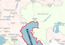
Sakhalin Island: where is it
It is washed by the waters of the Sea of \u200b\u200bOkhotsk and the Sea of \u200b\u200bJapan. It is separated from the mainland by the Tatar Strait, the width of which at its narrowest point (the Nevelskoy Strait) is 7.3 km, in the south of about. Hokkaido (Japan) is separated by the La Perouse Strait. Stretched meridionally from Cape Crillon in the south to Cape Elizabeth in the north. The length is 948 km, with an average width of about 100 km, on the isthmuses of Sakhalin it narrows: on Okhinskoye up to 6 km, on Poyask up to 27 km. The area is 76.4 thousand km2.
Sakhalin Island on the world map

Sakhalin Island: how to get there
There are two main ways to get to the island - air and water. As for the air: there are four passenger airports on Sakhalin: in Yuzhno-Sakhalinsk, Shakhtersk, Zonal and Okha. Of these there are regular flights to different cities on the mainland, including Moscow, Khabarovsk, Komsomolsk-on-Amur, Blagoveshchensk, Vladivostok, Sovetskaya Gavan, as well as to various cities in China, South Korea and Japan.
Two airlines fly from Moscow to Yuzhno-Sakhalinsk: from Sheremetyevo - Aeroflot, from Domodedovo - Transaero. Local airline that flies to different cities Of the Far East, - "Sakhalin air routes".
There are no flights from the village of Zonalnoe and the city of Shakhtersk to Yuzhno-Sakhalinsk, but from them you can fly to Sovetskaya Gavan and Khabarovsk. This can be done with the help of the Amur Airlines.
You can get from Vanino (Khabarovsk Territory) to Kholmsk (Sakhalin Region) by water. These ferries are daily and all year round. They run without a clear schedule, and the price grows every year, significantly outstripping inflation, plus it jumps depending on the season (more expensive in summer, cheaper in winter).
Sakhalin Island: video
Flight over Sakhalin
Painting of Sakhalin - the sunny island on Earth
Located in the far east of Russia, the Sakhalin Region includes islands, which is clearly visible on the map. The region includes Sakhalin Island and the Kuril Island Ridge.
Sakhalin is at east coast The Eurasian continent. Its area is 76.6 thousand km 2. The island is elongated in the north-south direction, about 950 km long.
From a geological point of view, Sakhalin is the northwestern part of the Pacific Ring of Fire, which also includes the Kuriles and the Japanese Islands. The island formations included in the "ring of fire" are characterized by earthquakes, often destructive, as well as volcanic eruptions. There are volcanoes on Sakhalin - mud volcanoes that are not dangerous for people.
It is believed that the name of the island originated from the name of the Amur on an old map. The name "Sakhalyan-Ulla", belonging to the river and mistakenly attributed to the island, was fixed thanks to later maps, where the island was called Sakhalin.
For the inhabitants of Japan, there is another name - Karafuto Island. The island is surrounded by the Okhotsk and Japanese seas. Between the island and the mainland there are 2 straits - Tatarsky and Nevelsky.
The Nevelskoy Strait is narrow, less than 7.5 km wide, and is covered with ice in winter. The Sea of \u200b\u200bOkhotsk and the Sea of \u200b\u200bJapan is connected by the La Perouse Strait, which separates the territory of Russia - Cape Krillon in the south of Sakhalin, from the northern japanese island Hokkaido. The strait is deep, on average 20-40 m, and wide (even in the narrowest part of 43 km), which makes it convenient for navigation.
The relief of Sakhalin emphasizes its shape. Mountain ranges stretched along the coasts, between them are low-lying areas. The northern part of the island is more low-lying, the southern part is predominantly mountainous with steep, rocky shores.
The coastline is indented, there are many small bays of round, elongated and bizarre shape. Some of the bays are separated from the sea by coastal ledges or islands.
How to get to Sakhalin
Sakhalin on the map of Russia gives an idea of \u200b\u200bthe distance to it. The fastest way to get there is by plane. There are 2 options: fly to Yuzhno-Sakhalinsk or Vladivostok.
Most convenient way getting to the island is a non-stop flight from Moscow to Yuzhno-Sakhalinsk airport. The flight takes about 8.5 hours. Modern liners are equipped with individual audio and video systems, each passenger has access to information about the flight. Travelers are provided with hot meals served twice. The time difference with Moscow is 8 hours.
If you were unable to purchase a ticket for a direct flight, you can fly to international airport in Vladivostok, then by plane 2 hours to Yuzhno-Sakhalinsk. 
Those wishing to see the country "from edge to edge" can be offered a train ride on the route Moscow - Vladivostok. There are 2 options: the branded train "Russia" and the luxury tourist class "Imperial Russia". The duration of the trip is at least 7 days. Then from Vladivostok in 2 hours by plane to Yuzhno-Sakhalinsk.
A more difficult option to get to Sakhalin is by ferry. The ferry crossing connects the mainland port of Vanino and the island port of Kholmsk. A regular bus runs between Kholmsk and Yuzhno-Sakhalinsk. You can get to Vanino by personal transport, but the road is of poor quality.
You can get to Vanino by train from Khabarovsk - 1 day, from Vladivostok - 2 days. The journey by ferry takes about 12 hours. If desired, personal transport is loaded onto the ferry upon prior reservation of a place for it. There is a gas station in Kholmsk, the A-392 highway will lead to Yuzhno-Sakhalinsk in an hour.
List of districts of the Sakhalin region with cities
Sakhalin on the map of Russia shows the ratio of its area and the total area of \u200b\u200bthe Kuril Islands. Sakhalin area is much larger than total area Smoked. The regional center is the city of Yuzhno-Sakhalinsk.
Sakhalin regions:

Kuril regions:
- Kuril;
- North Kuril;
- South Kuril.
The names of the district centers correspond to the names of the districts.
Climate features in different parts of the island
Sakhalin on the map of climatic zones of Russia is located in the monsoon climate of temperate latitudes. However, the climate in different areas is different. This is due to his geographic location (meridional elongation and location between seas with different characteristics), proximity to the huge continent and relief.
The proximity to Eurasia explains the general monsoon nature of the island's climate - the direction of winds in winter is north and northwest, in summer time southern and southeastern. The elongation of the island explains the difference in the amount of heat received by its northern and southern regions - it is colder on the northern shores than in the south. 
The cold East Sakhalin Current runs along the coast of the Sea of \u200b\u200bOkhotsk; the coast of the Sea of \u200b\u200bJapan is influenced by the warm Tsushima Current. Mountain ranges change the movement of air masses and protect river valleys from the invasion of cold. A feature of the island is the seasonal temperature shift. Here February is the coldest month, August is the warmest month.
The most comfortable area for summer tourism is the Susunai Valley of southern Sakhalin, which opens with a wide part into the Salmon Bay, located in an intermountain basin.
In the valley, moderately cold, rather humid winters with an average January temperature of -8 о С, humid, not very hot summers from +15 to + 20 о С. Summer precipitation prevails in August, in winter snow drifts reach 0.5 - 1.0 m However, snow does not hold everywhere, so skiers are better off choosing other areas.
The Tymovskaya valley of central Sakhalin is the most freezing place, as it is located between mountain ranges that prevent the penetration of moist sea masses that soften the frosts. The average February temperature is -26 o C, the minimum is -54 o C. Summer is hot, sometimes the temperature rises to + 30-38 o C, but at times frosts are possible.
Besides the special areas, there are the typical climatic characteristics of the entire island, as well as its north and south. Summers are humid and cool, fogs and rains are common, but the northern regions are warmer less.
The winter is snowy with snowstorms. Snow avalanches descend in the mountains, in some places the depth of the snow reaches 8 m. In the north, winter conditions are observed from the last days of October, in the south, winter comes later for a month and a half. 
The specificity of Sakhalin is typhoons coming from the Pacific Ocean. In summer - strong winds reaching hurricane speeds, and heavy rains, with possible floods, landslides and mud flows, destruction in settlements. In winter - snowstorms for several days, snow drifts up to 2 m, wire breaks, disruption of transport.
Inland waters
Sakhalin on the map of Russia is a region with a dense river network. However, most of the rivers belong to small rivers, mainly mountain ones. There are only two rivers on the island with a length of more than 300 km, several more with a length of 120-130 km.
There are more than 16 thousand lakes on the island.
The largest are of the lagoon type. Small lakes are represented by oxbow lakes, thermokarst and dammed lakes in the highlands.
 Lake Nevskoe on Sakhalin
 | Rivers | Lakes |
| Burrow | Nevskoe |
| The darkness | Tunaicha |
| Lutoga | Besse |
| Langeri | Ayinskoe |
| Rukutama |
Of these, the first 4 rivers flow into various bays of the Sea of \u200b\u200bOkhotsk, the last one into Lake Nevskoye.
Features of the flora and fauna of Sakhalin
Due to the peculiarities of the Sakhalin climate, the flora of the island requires separate consideration for each climatic region.
For the northern part, where plains and many wetlands prevail, mosses and lichens are ubiquitous. On rare meadows there are herbs and sedges. The taiga massifs consist mainly of larches and cedars. Firs and spruces appear to the south; dwarf cedar dominates the mountain slopes. 
The flora of southern Sakhalin is the most interesting. Northern taiga and southern species coexist here. Spruces and larches are entwined with vines of wild grapes and lemongrass. Shrubs of hydrangea and rhododendrons among yews and yellow maples.
Dwarf cedar grows next to cork, cherry blossom and weigela. The hollows are surrounded by ferns. Impenetrable thickets of Kuril bamboo are frequent in the undergrowth. In the river valleys common willows and alders are common for the middle zone, oaks and ash trees come across. The fauna of Sakhalin is not rich.
These are mainly taiga representatives:

Wild reindeer are still preserved in the north. There are many birds on Sakhalin, some stop here for rest on the way if they fly from afar. Indigenous species are common for the taiga and forests of Russia. On some secluded lakes, white swans hatch their chicks in summer. In the forests of southern Sakhalin, birds and butterflies are found, typical of the more southern region - the Hokkaido Islands.
The world's largest fur seal rookery is registered on Tyuleniy Island.
Minerals
The mineral resources of the island are very diverse. The main one is oil and gas deposits. Thanks to this, a unique production facility for liquefying gas is located on Sakhalin, which, along with oil, is successfully exported.
High quality bituminous coal is actively mined and used locally. Deposits of gold and germanium are important. At present, a rich deposit of chromite ores has been discovered. Large-scale construction has been launched on Sakhalin, so the extraction of limestone for cement production is also a priority.
In addition, there are many small occurrences of non-ferrous metals, but they are not yet developed. The region is characterized by valuable mineralized and hot underground waters, since the island is located in the Pacific Ring of Fire.
sights
Sakhalin on the map of Russia is far from major citiesand this is a good reason for excursion route... In Yuzhno-Sakhalinsk there is interesting placesaccessible to the public, as they are located in the central part of the city. You can get there by city buses.
Sports and Tourism Complex "Mountain Air"
From a special platform on Mount Bolshevik, you can see the city and the hills surrounding it. You can walk or climb with cable car.  It operates all year round, its beginning on Victory Square. At night, the complex shines with illumination lights.
Bear Museum
The museum contains exhibits that characterize the life and culture of the 18th-21st centuries. Numerous toys in the shape of bears, as well as products of famous Russian creative centers, attract attention.
Various workshops, a garden with live butterflies, and a planetarium are open for visitors. The museum is located on the 6th floor of the City Mall. You can get by bus from any area of \u200b\u200bthe city, including the airport and train Station.
Memorial to the soldiers who died during the battles of 1945 on the territory of Sakhalin and the Kuril Islands. This is an extensive complex with military equipment, sculptures, and busts of Heroes of the USSR.  The dead are named on the wall of memory. An eternal flame burns in their honor. In 2018, the guns and tanks of the memorial, damaged by the bad weather, were restored. The complex is located on Glory Square in the city center.
Sakhalin Regional Museum of Local Lore
Located on Kommunistichesky Prospekt in the building of the former Japanese Museum. A park with a fountain is set up on the territory of the museum complex, interesting exhibits are installed. Free admission. Internal exhibitions tell about the history and nature, culture of indigenous peoples, modern development of the region. The Department of Paleontology introduces the organisms that inhabited the region millions of years ago.
Sakhalin Zoo and Botanical Park
The zoo-botanical park occupies a vast territory on Detskaya street. As the name suggests, it is a botanical park with a zoo. Among the plants there are local wild plants, cultivated species, lianas, herbs, mushrooms. 
The zoo contains mammals, birds, it is interesting to visit the exatarium. You can touch animals in the petting zoo. In the zoo there is an opportunity to see the representatives listed in the "Red Book".
Chekhov Peak
The Susunaisky mountains are not very high, only 2 peaks rise above 1 thousand meters. These are the peaks of Pushkin and Chekhov. The height of Chekhov peak is 1045 m, Pushkin peak is slightly higher. Chekhov Peak is located near Yuzhno-Sakhalinsk. The ascent is not the most difficult, but appropriate footwear is required. You can climb to the top along a path where dangerous areas are marked, ropes are stretched, some stones are painted.
Plants and birds from the Red Book are found in some places. Although this is a favorite vacation spot for many townspeople, there are still sections of untouched landscapes. During the Japanese occupation of the island, a small temple was built on the highest site, the remains of which are still visible.
While climbing to the top, you can get acquainted with plants typical of Sakhalin: dwarf cedar and Kuril bamboo, rhododendrons and dwarf birches. A beautiful panorama opens from the top - hills, lakes, bays and Yuzhno-Sakhalinsk. It is easy to get from the city to the foot by car or on foot from the Yuri Gagarin park. You can buy a guided tour for 10 hours - from 9 to 19 hours.
Cape Giant
The natural monument Cape Velikan is a huge remnant of dense rock, cut by the wind for many thousands of years. But he is not the only one here, the entire coast to Cape Ptichiy looks like a museum of bizarre stone figures. A forest area descends almost to the water itself. Tourists can see bird colonies, seal rookeries, summer spawning movements of pink salmon. 
Fans of car trips should not rush to the shore in early spring, as part of the route runs along the coastal strip. A bulldozer makes the track more comfortable, which clears it at the start tourist season... If you wish, you can join the excursion, which is designed for 10 hours and starts in Yuzhno-Sakhalinsk.
Korsakov Sea Trade Port
The small town of Korsakov is located in Aniva Bay. The many berths, harbor cranes, and clean territory convey the development and importance of the harbor. Tankers and dry cargo vessels, small passenger ships and container ships.
Suitable for berths and cruise liners... The port provides communication between the island and the Kuril Islands and Japan. To see the panorama of the city and the port, you can climb observation deck... The road to Korsakov does not take much time: about 1 hour by regular bus or train, less than 1 hour by personal car.
The main lighthouse in Kholmsk
The small port city of Kholmsk is located on the southwestern coast of Sakhalin. There are 5 lighthouses in the city, some of them are Japanese, some are Soviet. The main lighthouse began operating in 1958. 
It is a striped tower made of reinforced concrete, rising 67 m above sea level, although its height is 29 m. The lighthouse performs 2 tasks - it acts as a light and radio beacon. The light signal comes on every night regardless of the season.
A regular bus leaves from Yuzhno-Sakhalinsk to Kholmsk every hour. By car, you can drive along the highway in 1.5-2 hours. There is a dirt road from the city to the lighthouse, but in winter time it is not cleared.
Yacht club "Vodnik" in the city of Kholmsk
The yacht club on Sovetskaya Street has existed since 1969 and unites children and adult sailboat enthusiasts. Club members participate in competitions, go sailing. Guys can get professional training to work on yachts of different types.
Quiet Bay
IN Quiet Bay only seagulls and waves running ashore make noise. From the wind, the bay is closed by rocks, cut by the wind. You can walk along the shore, look into the grottoes. Fishing, underwater world, beauty of coastal plants also attract amateurs. Fans of hiking in the mountains can climb the Zhdanko ridge, look into the distance, at the sea, and take interesting photos. 
Tikhaya Bay got its name from Ivan Kruzenshtern, a famous Russian sailor, but in winter there are strong winds and blizzards. Therefore, a winter visit to the bay can only appeal to professional rock climbers and athletes. You can get here by car or train from the Yuzhno-Sakhalinsk railway station... The train journey will take no more than 3 hours, the further journey is on foot.
Moneron Island
The island is located near the southwestern coast of Sakhalin and is a national natural marine park... This is a specially protected area with the possibility of educational tourism, so before the trip you need to familiarize yourself with the rules for visitors.
It is a small island, towering 440 m above the sea, an ancient volcano that has already collapsed. The main advantage of the protected area is the unique combination of landscapes in a small area. The relative inaccessibility for most tourists makes the tasks of the park staff easier.
Picturesque mountains, alpine meadows, gorges with steep walls, waterfalls, stone sculptures, small caves - all this can be seen on Moneron. A board trail has been laid especially for tourists, there are houses for visitors to the island, routes to the main attractions have been developed.
Around the island in summer, the sea is warm, the water is clear, so underwater photography is especially successful here. Of particular interest is the unique sea lion rookery, to which a special route has been laid.
They get here only by boat from the Nevelskoy port, which is not always possible due to the weather. For reliability, you can buy a tour for 2 days from Yuzhno-Sakhalinsk. Then there will be no need to worry about transport and excursions.
Rocks "Three Brothers"
In order to get to the rocks, you need to take a train in Yuzhno-Sakhalinsk, get to Tymovskoye station, change to a bus there and get to the first capital of Sakhalin, Aleksandrovsk-Sakhalinsky. 
Further - by taxi or on foot along the coast. Having decided to move around the island in a private car, you need to follow the highway. The final destination of the route is Cape Jonquier. It is here that natural monument "Three brothers". These are three rocks, similar to each other, but different in size. As brothers - senior, middle, junior. The picturesque group is placed on the coat of arms and flag of the city.
Fossil lovers can add samples of coal, ancient shells and plants to their collections.
On the shore you can see a lighthouse that has existed since the end of the 19th century, now dilapidated. Another interesting object is a tunnel through the rock, built at the same time, for a horse-drawn railway.
It was never used, as it was flooded at high tide, but you can still walk on it. At the exit from the tunnel, another group of three rocks is visible - "Three Sisters". They are smaller and less showy than "brothers".
Thermal springs
There are many thermal springs, since the island is located in the zone of active volcanoes. However, only 2 groups of all are used.

Supporters of organized treatment can purchase a ticket to the Dagi-Oasis sanatorium complex in the small village of Goryachy Klyuchi. Those who are used to living in hotels will be satisfied hotel room in the village of Nogliki. You can get here by train from Yuzhno-Sakhalinsk, then by car along an asphalt road.
- Not far from Yuzhno-Sakhalinsk there are Sinegorsk sources. Their composition is unique as they contain arsenic. The sanatorium has a staff of highly qualified specialists to assist vacationers. The sanatorium is located in the village of Sanatornoye, which is easily accessible by bus or car from Yuzhno-Sakhalinsk.
Ski resorts
In winter, the capital of the island offers the following options for vacationers:

It is important for tourists to determine the travel dates in advance. Although Sakhalin does not look very impressive on the map of winter tourism in Russia, winter months from the first days of December to the last days of April are suitable for skiers. Sanatoriums operate regardless of the season. Sightseeing is best postponed for the summer.
Article design: Mila Friedan
Video about Sakhalin
What is life on Sakhalin Island: